
Master road list - Berrien County Road Commission
Berrien County Road Commission
Road jurisdiction list
Road Name
12th Street
14th Street
14th Street
15th Street
18th Street
19th Street
1st Street
20th Street
21st Street
2nd Street
Aalfs Road
Aalfs Road
Abbey Lane
Able Road
Acorn Drive
Acorn Drive
Acorn Path
Adams Drive
Adams Road
Adams Street
Adams Street
Adams Street
Adams Street
Adams Street
Advance Way
Agard Avenue
Airport Drive
Airport Road
Alanar Court
Alberta Street
Alex Path
Algonquian Trail
Alice Avenue
Alice Court
Allen Drive
Allerton Drive
Alley
Alley
Alley
alleys
Allouez Drive
Alma Avenue
Alma Avenue
Alma Avenue
Alma Street
Alpine Court
Alpine Ridge
Amberjam Way
Ames Street
P=Primary Road
L=Local Road
S-Subdivision
* = Private
NM=Not Maintained
Location
Bell Rd to Lawndale
Thirteenth St to 14th Street
Apple Ln to Dewberry Ave
Apple Ln to Dewberry Ave
Broadway to end (North)
Br-60 to end (North)
Tower Hill Road to end (East)
Miller Dr to BR-60
Bertrand Rd to end (South)
Tower Hill to Middle Street
Little Glendora Rd to end (South)
Little Glendora Rd to end (North)
US-12 to Summerhill Lane
Wagner Road to Boyle Lake Road
Roosevelt to N. Cedar Trail
Valley View Dr to E. Valley View Dr
Red Arrow Hwy to end (West)
Washington Ave to end (East)
US-12 to Buffalo Road
Ridgeway to end
Central Ave to McCray
Park Street to end (South)
Bertrand Road to State Line
Betrand Rd to Madaline
Marquette Woods Road to end (South)
BH city limits to McKann St
M-140 to end (East)
Lake Street to Terminal Road
Manorwood Circle to end (North)
Burkett Avenue to Cook Avenue
Cleveland Avenue to end (East)
Indian Trail to end (South)
Lakeshore Road to Gowdy Pkwy
Lewis Dr to end (NE)
Empire Avenue to end
Fulkerson Rd to Parkview
Paw Paw Avenue to Campbell
Tyler to 20th Street
Shady Dr to end (North)
between Territorial and Highland
West River Road to Champlain Dr
East and West of McCord
Lakeshore Road to Streed Court
Townline Road to end (South)
Interlochen to end (Southeast)
S. Roosevelt Rd to end (West)
John Beers Road to Pawnee Path
Hinchman Rd to Suncrest Breeze
Emerson Avenue to end
Length
527'
Private
779'
591'
1884'
2551'
710'
1846'
1090'
Private
0.48
0.50
Private
1.25
1100'
567'
Private
1273'
1.00
940'
1320'
985'
1.03
850'
1223'
1324'
1164'
1.01
294'
Private
Private
833'
Private
250'
660'
563'
316'
3532'
120'
15787'
880'
300'
Private
710'
550'
432'
2835'
3013'
201'
BCRC Foreman
43
N/A
43
43
43
43
44
43
43
N/A
43
44
N/A
43
44
44
N/A
44
43
56
56
56
43
43
44
56
56
43
56
N/A
N/A
44
N/A
43
56
43
56
43
56
56
43
56
N/A
56
56
44
44
44
56
Township Type
Niles
S
Niles
*
Niles
S
Niles
S
Niles
S
Niles
S
Chikaming
S
Niles
S
Niles
S
Chikaming
*
Buchanan
L
Buchanan
L
N. Buffalo
*
Buchanan
L
Lincoln
S
St. Joseph
S
Chikaming
*
Lincoln
S
Galien
L
Benton
S
Hagar
S
Hagar
S
Niles
L
Niles
S
Lincoln
S
Benton
S
Watervliet
S
Niles
L
Benton
S
Benton
*
Lincoln
*
Chikaming
S
N. Buffalo
*
Niles
S
Benton
S
Niles
S
Benton
S
Niles
S
Watervliet
S
Benton
S
Bertrand
S
Benton
S
Chikaming
*
Sodus
S
Coloma
S
Lincoln
S
Lincoln
S
Oronoko
S
Benton
S
02/03/2015
Berrien County Road Commission
Road jurisdiction list
Road Name
Amy Court
Amy Drive
Amy Drive
Anderson Circle
Anderson Road
Andrews Road
Andrews Road
Angling Road
Angling Road
Anita Lane
Ann Court
Ann Drive
Anna Drive
Anna Lane
Ansley Drive
Anthony Drive
Appian Way
Apple Avenue
Apple Lane
Apple Lane
Applewood Drive
Arbor
Arbor Avenue
Arbor Ridge
Arbor Street
Arcadia Drive
Arent Court
Arent Road
Arlington Drive
Arlington Lane
Arlington Street
Armstrong Court
Arnold Court
Arnt Boulevard
Arrow Lane
Arrowhead Drive
Arrowhead Trail
Arrowood Curve
Ash
Ash Court
Ash Drive
Ash Road
Ash Street
Ashley Lane
Ashwood Drive
Ashwood Drive
Aspen Street
Atherton Drive
Augsburg Path
P=Primary Road
L=Local Road
S-Subdivision
* = Private
NM=Not Maintained
Location
Amy Drive to end (North)
Russell Road to Marlen Dr
Boyer Road to end (West)
Stevensville-Baroda Rd to end (South)
M-63 to Clanton Lane
North Main Street to Broceus School Rd
Buffalo Road to Olive Branch Road
Carmody Rd to Hill Ave
Hennesey Road to Ryno Road
Circle Drive to end (Southwest)
Rockey Weed Rd to Rockey Weed Rd
Cleveland Ave to Lynn Dr
Wilson Road to Victoria Ct
M-139 to Lauren Lane
M-63 to Lincoln Ave
Cleveland Ave to Crestview
Kephart Ln to end (East)
Lakeshore Road to Lakeview Ave
Marquette Dr to Kissman Dr
Thirteenth St to end (East)
Miners Road to end (North)
Marquette Dr to Prospect Dr
Pier Road to Eastern Avenue
Enterprise Way to end
Maiden Ln to Royalcrest Dr
Cleveland Avenue to Knox St
Mountain Road to I-94
Napier Ave to dead end
Sawyer Road to end (South & West)
Turfway Park to end (East & South)
Maiden Lane to Lonesome Pine Trl
Thirteenth St to end (West)
M-51 to end (East)
M-140 to end (East)
Red Arrow Hwy to end (East)
Tudor Rd to Chapin Ln
Landings Ln to end (NW)
Forest Point Road to Echo Road
Marquette Dr to Riviera Drive
Ash Dr to Dogwood Dr
Maple Dr to Oak Dr
Springbrook to Beech
Riverside Street to end (West)
M-63 (Niles Road) to end (Northeast)
S. Donna Dr to Clearwood
Sherwood Dr to N. Sierra Way
California Rd to John St
Coloma Road to Boyer Road
Lutheran Path to end (North)
Length
596'
919'
1108'
2136'
0.16
1.03
1.01
1.10
1.89
Private
662'
1595'
496'
1512'
3142'
2266'
820'
Private
585'
1315'
1319'
Private
721'
1025'
1012'
1157'
0.22
1.83
2076'
Private
662'
Private
382'
1335'
Private
1168'
685'
1206'
Private
864'
1152'
Private
335'
Private
315'
315'
330'
1616'
Private
BCRC Foreman
56
44
56
44
56
43
43
56
56
N/A
44
44
44
44
44
44
44
N/A
43 (44W)
43
44
N/A
56
56
44
44
56
56
44
N/A
44
N/A
42
56
N/A
44
44
56
N/A
43
43
N/A
56
N/A
44
44
44
56
N/A
Township Type
Coloma
S
Baroda
S
Coloma
S
Lincoln
S
Hagar
L
Buchanan
L
Galien
L
Bainbridge
L
Coloma
L
Chikaming
*
Lincoln
S
St. Joseph
S
Lincoln
S
Royalton
S
St. Joseph
S
St. Joseph
S
Oronoko
S
N. Buffalo
*
N. Buffalo
S
Niles
S
Royalton
S
N. Buffalo
*
Hagar
S
Benton
S
St. Joseph
S
Lincoln
S
Coloma
L
Bainbridge
L
Chikaming
S
Niles
*
St. Joseph
S
Niles
*
Niles
S
Watervliet
S
Lincoln
*
Oronoko
S
Royalton
S
Benton
S
N. Buffalo
*
N. Buffalo
S
N. Buffalo
S
Hagar
*
Hagar
S
St. Joseph
*
Lincoln
S
Lincoln
S
Weesaw
S
Coloma
S
Royalton
*
02/03/2015
Berrien County Road Commission
Road jurisdiction list
Road Name
August Drive
Augusta Street
Autumn Ridge
Avery Road
Avery Road
Avery Road
Avery Road
Bacon School Road
Bailey Road
Bainbridge Center Rd
Bakertown Road
Bakertown Road
Bakertown Road
Bal Moral Lane
Baldanza Avenue
Baldwin Avenue
Baldwin Avenue
Baldwin Avenue
Baldwin Avenue
Baldwin Drive
Baldwin Road
Baldwin Road
Barbara Ann Drive
Barbara Drive
Barbara Street
Barbara's Way
Bass Island Park Rd
Basswood Drive
Basswood Road
Basswood Road
Batchelder Court
Batten Road
Batten Road
Bay View Drive
Beach Path
Bear Cave Road
Beaver Dam Road
Beaver Dam Road
Beaver Drive
Becht Road
Beech
Beech Avenue
Beech Court
Beech Lane
Beech Street
Beech Street
Beechnut Drive
Beechwood Circle
Beechwood Circle
P=Primary Road
L=Local Road
S-Subdivision
* = Private
NM=Not Maintained
Location
Russell Rd to Fairplain Ave
Paw Paw Lake Road to Beech Ave
Dickenson Road to end (E & S)
Elm Valley Road to Warren Woods Rd
US-12 to Kruger Road
Olive Branch Road to US-12
Kruger Road to Elm Valley Road
Marquette Woods Road to Linden Drive
M-140 to end (North)
Meadowbrook to Carmody Road
US-12 to Buffalo Road
US-12 to Chamberlain Road
Chamberlain to W. Front Street
Country Club to Gleneagle Ln
Red Arrow Hwy to Taylor
Gregory Rd to E. Main Street
Orchard Blvd to Hillside Drive
Rea Ave to Peach Street
Forest Park Ln to end (East)
20th St to 20th St
Bridgman City Limits to Browntown Rd
Browntown Road to Sawyer Road
Cleveland Avenue to Ivy Drive
N & S of Roberts (East of Cleveland)
Wells Avenue to end
Swan's Way to end (East)
Marl Road to end
Marquette Drive to Elmwood Dr
US-12 to Elm Valley Road
US-12 to State line
Townline Ave to Gordon Drive
Dayton Road to Boyle Lake Road
Gardner Road to end (East)
Paw Paw Ave to Wil-O-Paw Drive
Oak Drive to Pine Drive
Red Bud Trail to end
Olive Branch Road to Spring Creek Rd
Buffalo Road to Olive Branch Road
E. Main Street to end
Paw Paw Avenue to Van Rd (48th Ave)
Hickory to Hillview
Paw Paw Lk Rd to Paw Paw Lk Rd
Maple Lane to Elm Drive
Elm Valley Road to end (North)
Pine Street to Maple Street
Cedar Ave to Hickory
Marquette Woods Rd to Joining Rd
Forest Beach Rd to Beechwood Circle
Glen Road to Glen Road
Length
1272'
485'
Private
1.00
1.01
2.06
1.05
2.28
4.47
5.41
0.61
0.57
1.03
505'
494'
1180'
Private
Private
2612'
3460'
2.00
0.98
609'
331'
573'
Private
Private
Private
1.90
2.89
Private
1.00
0.21
1222'
Private
Private
0.52
1.00
543'
4.02
Private
1596'
294'
Private
Private
328'
1548'
2930'
635'
BCRC Foreman
56
56
N/A
44
43
43
43
44
42
56
43
43
43
43
56
56
N/A
N/A
56
43
44
44
44
44
56
N/A
N/A
N/A
43
43
N/A
43
43
56
N/A
N/A
43
43
42
56
N/A
56
42
N/A
N/A
56
44
56
56
Township Type
St. Joseph
S
Coloma
S
Royalton
*
Chikaming
L
Galien
P
Galien
L
Three Oaks
L
Royalton
L
Pipestone
L
Bainbridge
L
Bertrand
L
Bertrand
P
Buchanan
P
Niles
S
Benton
S
Benton
S
Chikaming
*
Chikaming
*
Watervliet
S
Niles
S
Lake
L
Weesaw
L
Lincoln
S
Lincoln
S
Benton
S
Chikaming
*
Bainbridge
*
N. Buffalo
*
Three Oaks
L
Three Oaks P
N. Buffalo
*
Bertrand
L
Galien
L
Coloma
S
Chikaming
*
Buchanan
*
Galien
L
Galien
P
Berrien
S
Coloma
L
Hagar
*
Coloma
S
Berrien
S
Chikaming
*
Buchanan
*
Hagar
S
Royalton
S
Watervliet
S
Benton
S
02/03/2015
Berrien County Road Commission
Road jurisdiction list
Road Name
Beechwood Court
Beechwood Drive
Beechwood Place
Beechwood Terrace
Beeson Road
Behner Court
Behner Road
Behner Road
Bell Avenue
Bell Avenue
Bell Avenue
Bell circle
Bell Road
Bell Road
Bell Road
Bellwood Avenue
Belmont Lane
Belton Street
Benjamin Street
Benson Road
Benson Terrace
Benton Center Road
Benton Center Road
Benton Center Road
Benton Street
Berg Avenue
Berg Avenue
Berky Avenue
Berrien Avenue
Berrien Avenue
Berrien Street
Berrien Street
Berris Street
Berris Street
Berry Street
Bert Street
Bertram Road
Bertrand Road
Bertrand Road
Bertrand Road
Bessemer Road
Beth Street
Betty Mae Ave
Beveridge Avenue
Beverly Court
Biastock Road
Bicknell Street
Big Oak Lane
Birch Avenue
P=Primary Road
L=Local Road
S-Subdivision
* = Private
NM=Not Maintained
Location
Lakewood Trail to end
M-63 to M-63
Forest Beach Rd to Shore Ln
Rembert to Forest
Third St to Cedar Point Dr
US-12 to end (North)
US-12 to end (South)
Maudlin Road to end (North)
Higman Park to Ridgeway
Hazel to end
East Road to end (North)
Stevensville-Baroda Rd to end (East)
Bond Street to Third Street
Third Street to 17th Street
17th Street to County Line
Woods Avenue to end (North)
Keeneland Dr to end (East)
Third Street to end (East)
Russell Rd to end (East)
Paw Paw Avenue to M-63
Paw Paw Lake Road to end
Meadowbrook Road to end
Red Arrow Hwy to Duncan/Schmuhl Rd
Napier Avenue to Red Arrow Hwy
North Branch Rd to Eighth Street
N. Pike Road to end
Euclid Avenue to Gestner Dr
Paw Paw Lake Rd to end (Northwest)
Napier Avenue to end
Tower Hill to end (East)
Red Arrow Hwy to Lakeshore Road
W. of California Rd to end (East)
Third St to Mason St
Brick St to Madison
Old 31 to Diane Dr
Red Arrow Hwy to Taylor
Bond St to Adams St
Red Bud Trail to State Line
Red Bud Trail to Twp line
Twp line to County Line
Red Arrow Hwy to Coloma Road
Elizabeth Street to Joseph Street
Grove to Hillview
Britain to Roberts Ave
McIntosh to Laurel
Territorial to North Branch Rd
Fulkerson Rd to Wightman
Harbert Road to end (North)
Beechwood Drive to Hagar Place
Length
Private
0.93
not open
494'
3223'
0.16
0.37
0.32
425'
480'
Private
1900'
0.51
1.02
0.51
310'
Private
Private
634'
0.80
788'
0.17
0.82
3.93
Private
357'
846'
Private
972'
Private
0.29
1365'
400'
400'
1200'
494'
400'
1.98
4.74
2.09
1.76
302'
Private
800'
1115'
1.52
1325'
Private
1383'
BCRC Foreman
N/A
56
56
56
43
43
43
43
56
56
N/A
44
43
43
43
56
N/A
N/A
56
56
56
56
56
56
N/A
56
56
N/A
56
N/A
44
44
43
43
42
56
43
43
43
43
56
42
N/A
56
56
56
43
N/A
56
Township Type
Berrien
*
Hagar
L
Watervliet
S
Benton
S
Niles
S
N. Buffalo
L
N. Buffalo
L
N. Buffalo
L
Benton
S
Benton
S
Chikaming
*
Lincoln
S
Niles
L
Niles
P
Niles
P
Coloma
S
Niles
*
Niles
*
St. Joseph
S
Benton
L
Coloma
S
Benton
L
Benton
L
Benton
P
Benton
*
Benton
S
Benton
S
Coloma
*
Benton
S
Chikaming
*
Chikaming
L
Weesaw
S
Niles
S
Niles
S
Berrien
S
Benton
S
Niles
S
Bertrand
L
Bertrand
P
Niles
P
Hagar
L
Niles
S
Chikaming
*
Benton
S
Benton
S
Bainbridge
L
Niles
S
Chikaming
*
Hagar
S
02/03/2015
Berrien County Road Commission
Road jurisdiction list
Road Name
Birch Court
Birch Drive
Birchwood Drive
Birchwood Street
Birdie Avenue
Bishop Street
Black Lake Road
Blackberry Lane
Blackhawk Court
Blackhawk Drive
Blackhawk Trail
Blackhawk Trail
Blackwell Drive
Blaine Avenue
Blarney Court
Blatchford Road
Blenheim Road
Blossom Lane
Blossom Lane
Blue Creek Road
Blue Creek Terrace
Blue Ridge Path
Blue Ridge Road
Blue Star Highway
Bluebird Lane
Bluff Avenue
Bluff Court
Bluff Court
Bluff Creek Terrace
Bluff Road
Bluff Street
Bluff Street
Bluff View Drive
Bluffwood Terrace
Blum Street
Boardwalk
Boca Raton Lane
Bonanza Drive
Bond Street
Bond Street
Bonnie Avenue
Bonnie Drive
Boruchow Avenue
Boulder Ridge
Bowers Lane
Boyer Road
Boyer Road
Boyle Lake Road
Boyle Lake Road
P=Primary Road
L=Local Road
S-Subdivision
* = Private
NM=Not Maintained
Location
Spruce Lane to Juniper Drive
Magnolia Dr to Myes Ct
Prairie Road to Columbine
Puetz Road to end (West)
Highland Avenue to Dave
Donald Adkins Dr to McKann St
Hochberger Road to County Line Road
Boyer Road to end (West)
Longhorn Trail to end
Lakeside Road to end (East)
Blackhawk Trl bridge to end (North)
Napier Ave to Blackhawk Trail (private)
Holloway Drive to end (South and West)
Britain Avenue to Francis
Shillelagh to end (SW)
Paw Paw Lake Rd to N. Watervliet Rd
Windermere Dr to Windermere Dr
Quince Dr to Concord Rd (S. of Highland)
Marquette Dr to Kissman Dr
Territorial Road to Townline Road
Territorial to end (North)
Ridge Road to end (East)
Shortridge to Landward
Hagar Shore Road to County Line
Blackberry Lane to Blackberry Lane
M-63 to end (West)
Searles Ave to end (South)
Parker Ave to end (NE)
Territorial to end (North)
Thomas Road to end (North)
Francis to end (South)
Lake Ave to Terrace Ave
Pioneer Rd to Pioneer Ct
Dozer Road to M-63
Lakewood Drive to Lakewood Drive
Bacon School Road to end (East)
Country Club to Pinehurst
Echo Ridge to Joni Lane
Bertrand Road to Fort Street
Bertrand Rd to end (South)
Sawyer Road to Spaulding Avenue
S. Roosevelt Rd to end (West)
N & S of Syrkin Blvd
Lincoln Avenue to end (South)
Naomi Road to end (South)
North Branch to Carmody
Carmody Road to Coloma Road
Batten Road to Galien-Buchanan Road
Galien-Buchanan Road to Glendora Rd
Length
330'
602'
Private
720'
969'
660'
5.12
Private
362'
Private
Private
1793'
Private
1049'
275'
1.00
1058'
Private
483'
3.93
Private
Private
1268'
1.20
Private
Private
171'
943'
Private
Private
1854'
213'
2856'
3840'
1012'
Private
316'
1433'
2.68
1170'
Private
693'
Private
653'
570'
1.99
2.00
0.76
5.16
BCRC Foreman
44
42
N/A
44
56
56
42
N/A
44
N/A
N/A
56
N/A
56
43
56
44
N/A
43 (44W)
56
N/A
N/A
56
56
N/A
N/A
56
56
N/A
N/A
42
56
44
44
56
N/A
43
44
43
43
N/A
44
N/A
44
42
56
56
43
43
Township Type
Lincoln
S
Berrien
S
Chikaming
*
Lincoln
S
Benton
S
Benton
S
Pipestone
L
Coloma
*
Lincoln
S
Chikaming
*
St. Joseph
*
St. Joseph
S
Chikaming
*
Benton
S
Niles
S
Watervliet
L
Lincoln
S
Benton
*
N. Buffalo
S
Benton
L
Benton
*
Lincoln
*
Benton
S
Hagar
P
Coloma
*
Benton
*
St. Joseph
S
St. Joseph
S
Benton
*
Chikaming
*
Niles
S
Watervliet
S
Oronoko
S
St. Joseph
S
Coloma
S
Royalton
*
Niles
S
Lincoln
S
Niles
L
Niles
S
Chikaming
*
Lincoln
S
N. Buffalo
*
Lincoln
S
Sodus
S
Bainbridge
L
Coloma
L
Bertrand
L
Buchanan
L
02/03/2015
Berrien County Road Commission
Road jurisdiction list
Road Name
Boynton Avenue
Bradford Road
Brandywine Street
Brenda Road
Brenner Street
Brentwood Drive
Briar Road
Briarcliff Drive
Briarwood Drive
Briarwood Street
Brice Road
Brick Street
Brick Street
Bridgman Avenue
Bridgman Avenue
Bridle Path
Bridle Path
Bridlewood Trail
Bristol Terrace
Britain Avenue
Britain Avenue
Britain Avenue
Broadmoor Drive
Broadway Avenue
Broadway Avenue
Broadway Street
Broceus School Road
Broderick Road
Brook Court
Brook Point Lane
Brookfield Drive
Brookpark Drive
Brooks Street
Brookside Drive
Brookwood Drive
Brown Road
Brown School Road
Browning Drive
Browntown Road
Browntown Road
Browntown Road
Browntown Road
Brownway
Bruce Avenue
Brunden Place
Brunn Avenue
Buckhorn Street
Buena Vista Drive
Buena Vista Drive
P=Primary Road
L=Local Road
S-Subdivision
* = Private
NM=Not Maintained
Location
Britain Avenue to Lillian Street
Colfax Ave to N. Ottawa
M-51 to Thirteenth
Russell Rd to Commonwealth Rd
N & S of Syrkin Blvd
Washington Ave to end (West)
Portage Road to West River Road
Outer Dr to Valleyview Dr
Redwood Dr to Hedgewood Dr
Maplewood St to Redwood St
Wells Avenue to Baldwin
Ontario St to Sorin
Ontario St to Berris
Highland Avenue to Dave
E. Main Street to Red Arrow Hwy
Longmeadow Lane to end (East)
Meadow Grove to Carriage Ln
Long Lake road to Steeplechase Ln
Essex Court to end
Twp line to Park Road
Twp line to Paul Avenue
BH city limits to Paul Avenue
Napier Ave to Lormar Ave
BH city limits to Napier Avenue
Napier Avenue to Nickerson Avenue
18th St to 19th St
Madron Lake Road to Miller Road
Maple Lane to Riverside Road
Lonesome Pine Trl to end (North)
Demorrow Road to Echo Ridge
Maiden Lane to Lincoln Ave
Royal Queens Rd to Crownpoint Dr
Third St to Brick St
Niles-Buchanan Road to Woodside Dr
Niles-Buchanan Road to end
East Road to Lakeshore Road
Cleveland Avenue to Shoreham Village
Glenlord Road to Emerson Rd
Cleveland Avenue to Hills Road
Holden Road to Cleveland Avenue
Red Arrow Hwy to Tower Hill
Red Arrow Hwy to Holden Road
Jamesway to Fairplain Ave
M-51 to Bluff
Paw Paw Lake Road to end (West)
M-63 to Lydia Dr
Washington Ave to Wilshire Ter
100' S. of McCord
Paw Paw Lake Rd to Wil-O-Paw Drive
Length
436'
2163'
620'
647'
Private
1389'
1.53
1088'
670'
780'
813'
1140'
800'
1059'
2066'
Private
327'
1692'
Private
0.98
0.51
4.26
915'
0.52
3145'
567'
1.99
0.60
350'
1540'
1330'
330'
660'
1047'
1000'
0.72
0.27
1148'
2.07
1.00
0.65
4.28
2605'
778'
Private
1109'
935'
100'
890'
BCRC Foreman
56
56
43
56
N/A
44
43
44
44
56
56
43
43
56
56
N/A
44
42
N/A
56
56
56
56
56
56
43
43
56
44
44
44
44
43
43
43
44
44
44
44
44
44
44
56
42
N/A
44
44
56
56
Township Type
Benton
S
St. Joseph
S
Niles
S
St. Joseph
S
N. Buffalo
*
Lincoln
S
Bertrand
L
St. Joseph
S
Lincoln
S
Hagar
S
Benton
S
Niles
S
Niles
S
Benton
S
Benton
S
Niles
*
St. Joseph
S
Berrien
S
St. Joseph
*
Bainbridge
L
Benton
L
Benton
P
St. Joseph
S
Benton
P
Benton
S
Niles
S
Buchanan
L
Hagar
L
St. Joseph
S
Lincoln
S
Lincoln
S
Lincoln
S
Niles
S
Buchanan
S
Buchanan
S
Chikaming
L
St. Joseph
L
Lincoln
S
Baroda
L
Baroda
P
Lake
L
Lake
P
St. Joseph
S
Niles
S
Coloma
*
St. Joseph
S
Lincoln
S
Benton
S
Coloma
S
02/03/2015
Berrien County Road Commission
Road jurisdiction list
Road Name
Buffalo Road
Buffalo Road
Buffalo Road
Buffalo Road
Bundy Road
Bundy Road
Burgoyne Road
Burgoyne Road
Burgoyne Road
Burkett Avenue
Burkett Avenue
Burridge Road
Burrus Road
Burton Road
Burton Street
Butler Road
Butterfield Road
Butterfly Lane
Butternut Street
California Road
California Road
California Road
California Street
Calvary Road
Calvert Lane
Camelot Court
Camp Madron Road
Camp Road
Camp Warren
Campbell Avenue
Campbell Drive
Campbell Drive
Canterbury Road
Cardinal Court
Cardinal Drive
Cardinal Lane
Carey Mission Drive
Caribou Trail
Carley Lane
Carlisle Drive
Carlton Avenue
Carmody Road
Carmody Road
Carmody Road
Carmody Road
Carol Avenue
Carol Drive
Carol Lane
Carolyn Drive
P=Primary Road
L=Local Road
S-Subdivision
* = Private
NM=Not Maintained
Location
Mayflower Road to Twp line
Cleveland Avenue to Avery Road
Twp line to Cleveland Avenue
Hampton Road to Beaver Dam Road
Coloma Road to Twp line
Twp Line to Riverside Road
Madron Lake Road to Glendora Road
Glendora Road to Twp line
Lemon Creek Rd to Twp line
Townline Road to end (North)
Townline Road to Park St
Third Street to end (West)
Dayton Road to end
M-51 to County Line
Territorial to Highland
N. Pike Road to Wells Avenue
Elm Valley to Mayfair
US-31 to Rose Lane
E. Main Street to end
Red Arrow Hwy to Bridgman City Limits
Bridgman City Limits to Browntown Rd
Browntown Road to Glendora Road
Locke Road to end (West)
Territorial to end (South)
Fair Oaks to Thirteenth St
Cleveland Avenue to end
Madron Lake Road to end
Walton Road to E. Riverside Road
M-63 to end (West)
Madeline Ave to Alley
N. Watervliet Rd to end (NW)
Forest Beach Rd to Huntoon Ave
Elm Valley to Mayfair
Cardinal Dr to end (North)
Washington Ave to Lupin Dr
Union Pier Road to end (North)
Niles-Buchanan Road to Lykins Ln
Alpine Ridge to Alpine Ridge
Valley Ln to McLin Rd
Bacon School Rd to end
Pipestone Road to Hubbard
Hennesey Road to Carter Rd (Twp line)
Carter Road to Roslin Road
Hennesey Road to M-140
M-140 to County Line Road
Joan Dr to Jenny Ln
Columbus to Stanley
Roosevelt Road to E. Alice
Benson Road to end (South)
Length
7.32
3.33
2.26
1.00
0.70
1.46
1.11
1.00
4.05
Private
1869'
Private
0.55
0.64
1958'
938'
662'
1402'
818'
0.37
2.50
1.90
Private
Private
350'
Private
0.33
0.75
400'
335'
310'
not open
721'
300'
2129'
Private
1783'
800'
786'
1851'
599'
3.02
0.50
1.00
1.98
891'
298'
1050'
1167'
BCRC Foreman
43
43
43
43
56
56
43
44
44
N/A
56
N/A
43
42
56
56
44
44
56
44
44
44
N/A
N/A
43
N/A
43
42
56
56
56
56
44
44
44
N/A
43
44
44
44
56
56
56
56
56
42
56
44
56
Township Type
Bertrand
L
Galien
L
Galien
L
Galien
P
Coloma
L
Hagar
L
Buchanan
L
Buchanan
L
Oronoko
L
Benton
*
Sodus
S
Niles
*
Bertrand
L
Niles
L
Benton
S
Benton
S
Chikaming
S
Royalton
S
Benton
S
Lake
P
Lake
P
Weesaw
P
Chikaming
*
Benton
*
Niles
S
St. Joseph
*
Buchanan
L
Niles
L
Hagar
S
Benton
S
Watervliet
S
Watervliet
S
Chikaming
S
Lincoln
S
Lincoln
S
Chikaming
*
Niles
S
Lincoln
S
St. Joseph
S
Royalton
S
Benton
S
Coloma
L
Hagar
L
Watervliet
L
Watervliet
P
Niles
S
Benton
S
Lincoln
S
Benton
S
02/03/2015
Berrien County Road Commission
Road jurisdiction list
Road Name
Carolyn Street
Carolyn Street
Carolyn Street
Carpenter Road
Carpet Street
Carriage Lane
Carrie Lane
Carter Road
Case Street
Cass Street
Castle Court
Castner Drive
Catalpa
Catalpa Drive
Catherine Circle
Catherman Avenue
Cayuga Road
Cedar Avenue
Cedar Avenue
Cedar Avenue
Cedar Lane
Cedar Lane
Cedar Point Drive
Cedar Street
Celina Avenue
Center Avenue
Center Drive
Center Street
Center Street
Centerfield Drive
Central Avenue
Central Avenue
Central Avenue
Central Avenue
Chabot Road
Chalet on the Lake
Chamberlain Road
Chamberlain Road
Chamberlain Road
Champlain Drive
Chaparral Road
Chapel Road
Chapelgate Avenue
Chapin Lane
Charles Drive
Charles Street
Charles Trail
Charlestown Drive
Charmil Avenue
P=Primary Road
L=Local Road
S-Subdivision
* = Private
NM=Not Maintained
Location
Roosevelt to Van Buren
Wilson St to end (East)
Hagar Place to Jefferson St
Kaiser Road to Warren Woods Road
Welch Dr to end (North)
Meadow Grove to Bridle
Tucker Dr to Vinewood Dr
Carmody Road to Red Arrow Hwy
Red Arrow Hwy to end (South)
17th St to 19th St
Wilshire Ter to Wilshire Ter
Range Line Road to end
E & W of Tulip
Evergreen to Ash
White Pines to end (East)
Woodland to end
Miami Rd to Learning Ln
Wilson to Pershing
Cherry Avenue to end
W. Bundy to Elm Street
Jericho Road to Meadow Ln
River Road to end (East)
Bond St to end (W & N)
17th St to 19th St
Trebor Rd to end (South)
Red Arrow Hwy to Lakeshore Road
Holmes Dr to Woodland Dr
Deans Hill Road to Elm Street
Paw Paw Lake Rd to end
Kimber Ln to end (South)
Lakewood Drive to Lakewood Drive
Riverside Road to W. Hagar Shore Rd
Paw Paw Avenue to end (North)
Beechwood Circle to end (South)
Broderick Road to N. Chabot Road
Notre Dame Avenue to end (West)
Bakertown Road to Rynearson Road
Rynerson Road to US-31
Weiser road to US-31
Joliet to Allouez Dr
Tanglewood Trl to end (North)
M-140 to County Line
Copp Road to Chevy Chase
Tudor Road to end (East)
W. Alice to E. Alice
Highland Avenue to end
June Trace to Maple Ln
Williamsburg Dr to Norfolk
Paulmar Ave to Charmil Path
Length
1235'
1415'
1770'
1.00
497'
450'
1446'
0.44
Private
1293'
964'
1252'
Private
600'
515'
711'
1210'
380'
480'
735'
1112'
633'
1947'
1293'
476'
0.25
977'
380'
274'
843'
1531'
1.77
0.12
550'
1.01
Private
2.42
1.17
0.31
1100'
558'
2.59
873'
0.20
900'
1323'
367'
562'
426'
BCRC Foreman
56
56
56
44
44
44
44
56
N/A
43
44
42
N/A
43
44
56
56
56
56
56
44
42
43
43
44
44
43
42
56
44
56
56
56
56
56
N/A
43
43
43
43
44
42
43
44
44
56
44
44
44
Township Type
Hagar
S
Hagar
S
Hagar
S
Weesaw
L
Lincoln
S
St. Joseph
S
St. Joseph
S
Coloma
L
Watervliet
*
Niles
S
Lincoln
S
Berrien
S
Chikaming
*
N. Buffalo
S
Lincoln
S
Benton
S
St. Joseph
S
Hagar
S
Hagar
S
Hagar
S
Lake
S
Sodus
S
Niles
S
Niles
S
St. Joseph
S
Chikaming
L
Niles
S
Berrien
S
Coloma
S
Oronoko
S
Coloma
S
Hagar
L
Watervliet
L
Watervliet
S
Hagar
L
Lincoln
*
Buchanan
L
Niles
L
Niles
L
Bertrand
S
Royalton
S
Berrien
L
Bertrand
S
Oronoko
L
Lincoln
S
Benton
S
St. Joseph
S
Lincoln
S
Lincoln
S
02/03/2015
Berrien County Road Commission
Road jurisdiction list
Road Name
Charmil Path
Chase Lane
Cherokee Drive
Cherokee Trail
Cherry Avenue
Cherry Beach Road
Cherry Drive
Cherry Lane
Cherry Lane
Cherry Street
Cherry Street
Cherry Street
Chestnut
Chestnut Avenue
Chestnut Path
Chestnut Street
Chestnut Street
Chevy Chase Street
Chicago Avenue
Chicago Avenue
Chicago Avenue
Chicago Road
Chicago Road
Chikaming Street
Chippewa Road
Chippewa Street
Christiana Court
Christiana Drive
Chruch Street
Church Street
Church Street
Churchill Lane
Cinema Way
Circle Court
Circle Drive
Circle Drive
Circle Drive
Circle Ridge Drive
Clanton Lane
Clardelle Avenue
Claredon Place
Clark Avenue
Clark Street
Clark Street
Clarys Court
Clawson Road
Clawson Road
Clay Drive
Clay Street
P=Primary Road
L=Local Road
S-Subdivision
* = Private
NM=Not Maintained
Location
Charmil Ave to end (West)
Old Field Road to end (North)
Interlochen to end
Seneca Rd to Seneca Rd
Beechwood Drive to Hagar Place
Red Arrow Hwy to end
Baldwin Road to Woodridge Dr
Orchard Drive to end (North)
Thirteenth Street to end (East)
Interlochen to Clark
Meadow Ln to Kephart Ln
Red Arrow Hwy to Elm Street
Prairie Road to end (West)
Beechwood Drive to Hagar Place
Roosevelt Road to end (East)
Chicago to Highland
Red Arrow Hwy to Elm Street
Woodland to end
Territorial to Magarette
Michigan Ave to end (East)
Notre Dame Ave to Michigan Ave
Bertrand Road to US-31
US-31 to US-12
Red Arrow Hwy to Tower Hill
Colfax Ave to Miami Rd
Adrews Road to Buch. City Limits
Youngren Road to end (North)
Niles-Buchanan Rd to Platt St
Hinchman Rd to Scottdale Rd
State Line Road to Gary Street
Ontario St to Gary St
Keeneland Dr to end (East)
Mall Drive to end
Meadow Wood Dr to end (Southwest)
Plaza Drive to end
Red Arrow Hwy to Gottlieb Grove
Vineland Rd to Circle Dr
Woodland Dr to Woodland Dr
M-63 to Anderson Road
Colfax Avenue to Columbus
Kephart Ln to end (SE)
Pipestone Road to Hubbard
Little Paw Paw Lake to end (South)
M-51 to end (East)
N. Wolcott to Red Arrow Hwy
Sommer Road to Black Lake Road
E. Eureka Road to Old M-62
County Line Road to end (West)
US-12 to New Buffalo City limits
Length
Private
Private
498'
1005'
2190'
0.33
680'
165'
Private
636'
740'
393'
Private
1283'
Private
1304'
393'
742'
2540'
Private
712'
3.33
0.97
Private
3600'
1064'
Private
2709'
634'
Private
725'
Private
2099'
366'
1426'
Private
826'
2320'
0.09
1923'
786'
599'
634'
1681'
Private
2.97
1.20
Private
0.07
BCRC Foreman
N/A
N/A
56
56
56
44
44
44
N/A
56
44
56
N/A
56
N/A
56
56
43
56
N/A
44
43
43
N/A
56
43
N/A
43
44
N/A
43
N/A
56
43 (44W)
56
N/A
44
43
56
56
44
56
56
42
N/A
42
42
N/A
43
Township Type
Lincoln
*
N. Buffalo
*
Coloma
S
St. Joseph
S
Hagar
S
Chikaming
L
Lake
S
Lincoln
S
Niles
*
Coloma
S
Oronoko
S
Watervliet
S
Chikaming
*
Hagar
S
Lincoln
*
Benton
S
Watervliet
S
Bertrand
S
Benton
S
Lincoln
*
Lincoln
S
Bertrand
L
Bertrand
L
Chikaming
*
St. Joseph
S
Buchanan
S
Chikaming
*
Niles
S
Oronoko
S
Niles
*
Niles
S
Niles
*
Benton
S
N. Buffalo
S
Benton
S
Chikaming
*
St. Joseph
S
Niles
S
Hagar
L
Benton
S
Oronoko
S
Benton
S
Coloma
S
Niles
S
Chikaming
*
Pipestone
L
Pipestone
L
Watervliet
*
N. Buffalo
L
02/03/2015
Berrien County Road Commission
Road jurisdiction list
Road Name
Clearbrook Drive
Clearwood Drive
Clemens Avenue
Cleveland Avenue
Cleveland Avenue
Cleveland Avenue
Cleveland Avenue
Cleveland Avenue
Cleveland Avenue
Cleveland Avenue
Clinton Road
Closson Drive
Clymer Road
Clymer Road
Codi Street
Colfax Avenue
College Avenue
College Street
Collins Avenue
Coloma North Road
Coloma Road
Coloma Road
Colonial Drive
Colton Drive
Columbia Avenue
Columbine Drive
Columbus Avenue
Columbus Avenue
Comiskey Road
Commonwealth Road
Commonwealth Road
Community Hall Road
Concord Drive
Concord Drive
Concord Ridge Boulevard
Concord Road
Concord Road
Congress Street
Connell Court
Cook Avenue
Cook Avenue
Cook Place
Coolidge Avenue
Copp Road
Cora Court
Cornellia Street
Cornerstone Place
Cottage
Cottage Lane
P=Primary Road
L=Local Road
S-Subdivision
* = Private
NM=Not Maintained
Location
Echo Ridge to Joni Lane
Cleveland Ave to Orchard Dr
Royalton Heights Rd to Lincoln Ave
Linco Road to Browntown Road
Galien-Buchanan Rd to Galien Village
Galien Village Limits to State Line
Maiden Lane to Linco Road
Hilltop Road to Maiden Lane
Glendora Road to Galien-Buchanan Rd
Browtown Road to Glendora Road
Wells Avenue to end
Paw Paw Avenue to end
Hagar Shore Road to Van Road
Little Paw Paw Lake Rd to Hagar Shore
Jeffrey Court to end (South)
BH city limits to Nickerson Avenue
BR-31 to end (North)
State Line Rd to end (North)
Paw Paw Avenue to North Shore Rd
Paw Paw Lake Road to Van Road
Coloma City Limits to Bundy Road
M-63 to Bundy Road
Paw Paw Avenue to end (East)
Garr Road to end (East)
M-140 to County Line Road
Birchwood Drive to end (West)
Napier Avenue to Pearl
BH city limits to end
Longhorn Trail to end
Napier Ave to Hoover Ave
Hoover Ave to Brenda Rd
Union Pier Road to Lakeshore Rd
Range Line Road to end
Fox Crossing to end (East)
Marquette Woods Rd to Knollwood Dr
Highland Avenue to end
East and West of High Point Dr
Silsbee St to Bertrand Rd
M-139 to Indiana
Townline Road to end (North)
Townline Road to end (South)
Red Arrow Hwy to end (West)
East and West of Herr Court
Bertrand Road to State Line
Lake Road to end (North)
Chicago to Highland
N. Crystal Avenue to end
Lawton Avenue to Forest Glen Road
Lakeshore Rd to Community Hall Rd
Length
1600'
1307'
2052'
5.95
0.21
2.60
4.50
2.07
5.05
0.97
1638'
946'
0.92
0.99
Private
1.00
0.24
1633'
0.49
3.41
1.44
3.67
1183'
Private
2.00
Private
1147'
332'
1349'
1326'
2227'
1.36
3290'
168'
1070'
Private
655'
850'
445'
Private
330'
Private
453'
0.90
Private
1304'
1150'
575'
Private
BCRC Foreman
44
44
44
44
43
43
44
44
43
44
56
56
56
56
N/A
56
44
43
56
56
56
56
56
N/A
42
N/A
56
56
44
56
56
43
42
44
44
N/A
56
43
56
N/A
56
N/A
56
43
N/A
56
56
56
N/A
Township Type
Lincoln
S
Lincoln
S
St. Joseph
S
Baroda
P
Galien
P
Galien
P
Lincoln
P
St. Joseph
P
Weesaw
P
Weesaw
P
Benton
S
Benton
S
Coloma
L
Coloma
P
N. Buffalo
*
Benton
P
Oronoko
L
Niles
S
Benton
L
Coloma
P
Coloma
P
Hagar
P
Hagar
S
Oronoko
*
Pipestone
P
Chikaming
*
Benton
S
Benton
S
Lincoln
S
St. Joseph
S
St. Joseph
S
N. Buffalo
L
Berrien
S
Lincoln
S
Royalton
S
Benton
*
Benton
S
Niles
S
Benton
S
Benton
*
Sodus
S
Lake
*
Benton
S
Bertrand
L
Coloma
*
Benton
S
Benton
S
Benton
S
N. Buffalo
*
02/03/2015
Berrien County Road Commission
Road jurisdiction list
Road Name
Cottonwood Lane
Council Circle
Council Court
Country Aire Drive
Country Club Drive
Country Knoll Place
Country Lane
Country Lane
County Line Road
County Line Road
County Line Road
County Line Road
County Line Road
Courtney Street
Cove Path
Coveney Road
Coveney Road
Coveney Road
Crackerjack Lane
Craig Street
Cranbrook Road
Crawford Drive
Creek Lane
Creek Road
Creek View
Crescent Lane
Crest Drive
Crest Haven Boulevard
Crestview Drive
Crestview Drive
Cribbs Avenue
Cross Creek
Crownpoint Road
Crystal Avenue
Crystal Court
Cupid Lane
Curran Road
Curtis Drive
Cushing Road
Cygnet Lake Drive
Dale Avenue
Dallas Court
Damico Court
Damon Drive
Dan Smith Road
Dana Drive
Daniel Boone Trail
Daniel Street
Danneffel Road
P=Primary Road
L=Local Road
S-Subdivision
* = Private
NM=Not Maintained
Location
Harbert Road to end (North)
Mocassin Trail to end (NE)
Crystal Avenue to end
Paw Paw Lake Road to Walnut Ave
Thirteenth St to end (East)
Washington Avenue to end (West)
Sawyer Road to end (North)
Strawberry Street to end (West)
Napier Avenue to Meadowbrook Rd
Napier to Territorial
Territorial to Carmody Rd
Columbia Avenue to Meadowbrook Rd
Carmody Road to Red Arrow Hwy
Miners Road to end (South)
M-63 to Lakeshore Avenue
Wagner Road to Glendora Road
Glendora Road to Freehling Road
Mt Tabor Road to Freehling Road
Lakeshore Road to end (West
Walton Road to Joseph Street
Knox Ave to end (East)
N. Pike Road to Wells Avenue
Old 31 to end
Pucker Street to Twp line
Echo Ridge to Brook Point Ln
Ferndale Blvd to Fourteenth St
Hillside to Hill
Amberjam Way to Garr Road
Sawyer Road to end (South)
Maiden Ln to S. Valley View Dr
Britain to Wabash
Oak Drive to Pine Drive
Jericho Road to Brookpark Drive
Napier Avenue to Red Arrow Hwy
Crystal Avenue to end
Beechwood Circle to end (East)
Red Bud Trail to Dayton Road
Paw Paw Ave to Wil-O-Paw Drive
Clawson Road to Coutny Line
N/S of Trumpeter Bay Drive
Russell Rd to Fairplain Ave
Southfork Dr to end (West)
Riverside Road to end
Riverside Road to end (North)
Hennesey Road to County Line Road
Garr Road to end (West)
Old 31 to Pokagon Road
Riverside Rd to Jay St
M-140 to Countyline Road
Length
Private
320'
Private
Private
2566'
1232'
Private
Private
0.97
1.61
3.22
2.51
2.68
915'
Private
1.96
1.00
1.75
Private
1061'
433'
938'
Private
2.43
730'
989'
246'
1982'
Private
1615'
662'
Private
880'
2.42
Private
175'
4.06
1516'
1.00
Private
1290'
240'
579'
935'
3.00
Private
1.23
807'
2.02
BCRC Foreman
N/A
44
N/A
N/A
43
44
N/A
N/A
42
56
56
42
56
44
N/A
43
44
44
N/A
42
44
56
N/A
42
44
43
42
44
N/A
44
56
N/A
44
56
N/A
56
43
56
42
N/A
56
44
56
56
56
N/A
42
42
56
Township Type
Chikaming
*
Oronoko
S
Benton
*
Coloma
*
Niles
S
Lincoln
S
Chikaming
*
N. Buffalo
*
Bainbridge
L
Bainbridge
L
Bainbridge
P
Pipestone
L
Watervliet
P
Royalton
S
Hagar
*
Buchanan
L
Buchanan
L
Oronoko
L
Chikaming
*
Niles
S
St. Joseph
S
Benton
S
Berrien
*
Niles
L
Lincoln
S
Niles
S
Berrien
S
Oronoko
S
Chikaming
*
St. Joseph
S
Benton
S
Chikaming
*
Lincoln
S
Benton
P
Benton
*
Watervliet
S
Bertrand
L
Coloma
S
Pipestone
L
Benton
*
St. Joseph
S
Lincoln
S
Benton
S
Hagar
S
Watervliet
L
Oronoko
*
Berrien
L
Niles
S
Bainbridge
L
02/03/2015
Berrien County Road Commission
Road jurisdiction list
Road Name
Dara Street
Date Road
Davar Avenue
Dave Avenue
David Street
Davis Road
Davis Street
Dayton Dells Road
Dayton Road
De Witt Ave
Deadwood Avenue
Deans Hill Road
Deans Hill Road
Dearborn Street
Deer Meadow Lane
Deer Path
Deerfield Street
Deerwood Trail
Defay Road
Defield Road
Del Norte
Delaware Avenue
Dell Street
Delsing Road
Delta Avenue
Delta Avenue
Demorrow Road
Denman Lane
Dennis Street
Denton Drive
Depot Street
Derby Circle
Derfla Drive
Derry Drive
Desmond Court
Desmond Street
Destiny Way
Detroit Street
Dewberry Avenue
Dewey Avenue
Dewey Avenue
Dexter Avenue
Diamond Drive
Diane Drive
Dickinson Court
Dickinson Drive
Dickinson Road
Dillenbeck Lane
Diller Road
P=Primary Road
L=Local Road
S-Subdivision
* = Private
NM=Not Maintained
Location
Elizabeth Street to Janice Street
Linco Road to Browntown Road
Fair Avenue to end
Birdie Ave to Bridgman Ave
Riverside Rd to Jay St
Glendora Road to Hills Road
Third St to end (East)
US-12 to end (North)
Galien-Buchanan Road to State Line
M-51 to Twelfth St
Paw Paw Lake Road to Woodward
Old 31 to Hochberger
Hochberger to Pucker Street
Jefferson to Washington
Long Lake Road to Pheasant/Whitetail
Wildflower Way to end (West)
Washington Ave to Wilshire Ter
Marquette Woods Road to end (South)
Jericho Road to Red Arrow Hwy
Coloma City Limits to Hagar Shore Road
S. Sierra Way to El Dorado
Colfax Avenue to Union Avenue
Arlington to Arbor
Broadway to Kublick
Mizpah Park to The Midway
N & S of Derfla Drive
Village Limits to Stevensville-Baroda Rd
Greenbrush Road to end
John Beers Road to end (North)
Kipling Ct to Emerson Rd
Dayton Road to end
Centerfield Drive to end (East)
Bacon School Rd to end (East)
Shannon Way to end (East & West)
Desmond Street to end
Washington Ave to Desmon Ct
Wilson Road to north end
Wee-Chik Rd to end (North)
14th St to 15th St
Napier Avenue to Townline Road
Townline Road to end (South)
Territorial to Gregory Rd
Colonial Drive to end (North)
Old 31 to Berry Street
Dickinson Drive to North/South cul-de-sac
Dickinson Road to Dickinson Court
US-31 to end (East)
Linwood Drive to end (South)
M-139 to Twp line
Length
690'
6.01
530'
1003'
768'
1.09
565'
Private
4.09
811'
670'
1.35
3.37
802'
860'
Private
1066'
1438'
0.47
2.32
330'
3952'
330'
763'
305'
316'
0.60
?
1286'
660'
2002'
755'
3963'
857'
185'
1290'
Private
495'
655'
1.18
330'
555'
317'
750'
909'
1428'
0.68
Private
0.16
BCRC Foreman
42
44
56
56
42
44
43
N/A
43
43
56
42
42
56
42
N/A
44
44
44
56
44
56
44
56
56
44
44
44
44
44
43
44
44
44
44
44
N/A
44
43
56
56
56
56
42
44
44
44
N/A
56
Township Type
Niles
S
Lake
L
Benton
S
Benton
S
Niles
S
Buchanan
L
Niles
S
Bertrand
*
Bertrand
P
Niles
S
Coloma
S
Berrien
P
Berrien
P
Hagar
S
Berrien
S
Niles
*
Lincoln
S
Lincoln
S
Lincoln
L
Coloma
L
Lincoln
S
Benton
S
St. Joseph
S
Benton
S
Hagar
S
Royalton
S
Lincoln
L
Chikaming
S
Lincoln
S
Lincoln
S
Bertrand
S
Oronoko
S
Royalton
S
Royalton
S
Lincoln
S
Lincoln
S
N. Buffalo
*
Weesaw
S
Niles
S
Benton
L
Sodus
S
Benton
S
Hagar
S
Berrien
S
Royalton
S
Royalton
S
Royalton
L
Chikaming
*
Benton
L
02/03/2015
Berrien County Road Commission
Road jurisdiction list
Road Name
Diller Road
Dingman Avenue
Dixie Drive
Dobie Drive
Doda Street
Dogwood Drive
Dogwood drive
Dogwood Street
Dogwood Trail
Dohm Road
Dominick Drive
Donald Adkins Drive
Donald Adkins Drive
Donald Street
Donner Road
Doty Road
Douglas Avenue
Douglas Street
Douglas Terrace
Dover Lane
Downey Drive
Downing Avenue
Downing Avenue
Dozer Drive
Dozer Drive
Dreamcatcher Road
Drew Drive
Drexel Place
Driftwood Path
Duncan Road
Dune
Dune Lane
Dune Path
Dune Road
Duneridge Path
Dunes Road
Dunes Valley Path
Dunham Avenue
Dunham Lane
Dunham Path
Dunsenbury Street
Dutch Lane
Dutch Lane
Dwight Boyer Road
E. Algonquin Drive
E. Alice Drive
E. Alice Street
E. Bonny Bruce Drive
E. Bundy Road
P=Primary Road
L=Local Road
S-Subdivision
* = Private
NM=Not Maintained
Location
Twp line to end (East)
Turner Road to end (North)
Empire Avenue to end
Tanglewood Trl to Tanglewood Trl
St. James Street to St. Thomas Street
Grand Beach Rd to Ridgeview
Maplewood to Kephart Ln
Riverside Street to end (West)
Stonecreek Dr to end (South)
Naomi Road to end (North)
Riverside Road to end (Northwest)
Broadway Avenue to Jennings
Union Avenue to Milton
John Beers Road to end (North)
Three Oaks Road to Philllips Road
Blatchford Road to High Street
Woodland to Wilson
Baldwin to end
Paw Paw Avenue to end (North)
Camelot Court to Essex Court
Jakway Ave to Russell Rd
Pipestone Road to end (S. of Napier)
Pipestone Road to end (North)
M-63 (Niles Road) to end (Northeast)
Dozer Rd to end (North)
McCormick Trail to end
Valley View Dr to Valley View Dr
Oak Lane to end (North)
Ridge Road to end (West)
Benton Center Road to end (East)
Main to end (West)
Oak Lane to end (Southh)
M-63 to end (West)
Birchwood Drive to end (North)
Ridge Road to end (West)
Browntown Road to Grove Avenue
Ridge Road to end (West)
Grand Mere Rd to Dunham Path
Lake Street to Pine Street
Dunham Avenue to end (North)
Parkside Ln to Lykins Ln
River Road to West Side Drive
Pipestone Road to end (West)
N. Watervliet Road to County Line Road
Pipestone Road to W. Algonquin Dr
Migiel Lane to end
Carol Ln to Charles Drive
S. Bonny Bruce to end (North)
Central Avenue to I-196
Length
0.62
Private
1324'
2025'
265'
2892'
1722'
190'
Private
0.66
Private
1850'
992'
1286'
1.30
0.30
338'
195'
1010'
Private
1345'
1885'
676'
0.39
1200'
381'
1103'
668'
Private
0.47
Private
415'
Private
Private
Private
Private
Private
1538'
512'
Private
915'
0.91
0.45
1.25
950'
Private
330'
500'
0.39
BCRC Foreman
56
N/A
56
44
56
43
44
56
N/A
42
N/A
56
56
44
43
56
56
43
56
N/A
56
56
56
44
44
44
43
44
N/A
56
N/A
44
N/A
N/A
N/A
N/A
N/A
44
44
N/A
43
42
42
56
56
N/A
44
44
56
Township Type
Sodus
L
Chikaming
*
Benton
S
Royalton
S
Benton
S
N. Buffalo
S
Oronoko
S
Hagar
S
Bertrand
*
Sodus
L
Hagar
*
Benton
S
Benton
S
Lincoln
S
Three Oaks
L
Watervliet
L
Benton
S
Niles
S
Coloma
S
St. Joseph
*
St. Joseph
S
Benton
S
Benton
S
St. Joseph
L
St. Joseph
S
Lincoln
S
Niles
S
Lincoln
S
Lincoln
*
Hagar
L
Chikaming
*
Lincoln
S
Hagar
*
Chikaming
*
Lincoln
*
Chikaming
*
Lincoln
*
Lincoln
S
Lincoln
S
Lincoln
*
Niles
S
Sodus
L
Sodus
L
Watervliet
L
Sodus
S
Chikaming
*
Lincoln
S
Lincoln
S
Hagar
L
02/03/2015
Berrien County Road Commission
Road jurisdiction list
Road Name
E. Center Street
E. Chestnut Avenue
E. Clear Lake Rd
E. Donna Drive
E. Euclid Avenue
E. Eureka Road
E. Hiawatha Lane
E. Lake Lane
E. Locke Road
E. Main Street
E. Main Street
E. Main Street
E. Main Street
E. Main Street
E. Nickerson Avenue
E. Ogden Avenue
E. Park Lane
E. River Road
E. Thar Road
E. Trillium Circle
E. Valleyview Drive
Eagle Lane
Eaman Road
Eaman Road
Earl Street
East Geyer Road
East Riverside Road
East Riverside Road
East Road
East Street
East Winn Road
East Winn Road
East Wolcott Avenue
Eastern Avenue
Eastern Avenue
Eastfield Drive
Eastland Avenue
Eastman Avenue
Eastview Drive
Easy Lane
Easy Street
Easy Street
Eau Claire Road
Echo Hill
Echo Ridge
Echo Road
Echo Valley Drive
Ecker Place
Ed-Berth Drive
P=Primary Road
L=Local Road
S-Subdivision
* = Private
NM=Not Maintained
Location
Coloma City Limits to Red Arrow Hwy
Hagar Place to end (East)
Elm Valley Road to end
S. Donna Dr to N. Donna Dr
Red Arrow Highway to Benton Center Rd
M-140 to Brush Lake Road
John Beers Road to Minnie Ha-Ha Dr
Tower Hill to end (East)
Locke Road to end (East)
Benton Center to end
Euclid Avenue to Vernon St
Urbandale Ave to Bridgman Ave
Silverbrook Ave to Cass County Line
Village Limits to M-140
Pipestone Road to end (NW)
Ogden Ave to W. Ogden Ave
Maple Lane to W. Park Lane
Range Line Road to Mead Road
Bundy Road to Thar Road
Symphony Ln to end (East)
Briarcliff to N. Valley View
Wildflower Way to end (North)
Riverside Road to Zoschke Road
Zoschke Road to M-63
Bertrand Rd to end (South)
Walton Rd to Riverside Rd
Twp line to Smith Road
Smith Road to end
Three Oaks Road to Lakeside Road
Bertrand Rd to end (South)
Walton Road to US-31
BR-31 to Walton Road
Red Arrow Hwy to end
Colfax Avenue to Broadway Avenue
N & S of Arbor Avenue
Fulkerson Rd to Westfield
Crystal to John McCoy Sr Drive
Britain Avenue to Francis
Philip Rd to Southworth Dr
Harbert Road to end (North)
Benton Center Rd to end
Charles Trl to end (S & W)
Hochberger to Eau Claire Village limits
Oak Grove Avenue to end (East)
John Beers Road to Joni Lane
Forest Point Road to end
Philip Road to end (East)
Pier Road to M-63
Lubke Road to end (West)
Length
0.21
190'
1.19
268'
2.53
2.02
1150'
Private
Private
0.36
0.64
0.44
0.75
0.72
0.30
1044'
1278'
3.15
0.24
215'
739'
Private
0.12
1.47
1074'
1258'
1.01
1756'
3.00
1142'
1.06
0.78
0.46
1266'
1049'
590'
1958'
1049'
387'
Private
660'
636'
1.60
Private
3890'
1335'
3115'
470'
400'
BCRC Foreman
56
56
43
44
56
42
44
N/A
N/A
56
56
56
43
42
56
56
56
42
56
44
44
N/A
56
56
43
42
42
42
44
43
42
42
44
56
56
43
56
56
43
N/A
56
44
42
N/A
44
56
43
56
43
Township Type
Coloma
P
Hagar
S
Buchanan
L
Lincoln
S
Benton
L
Pipestone
L
Lincoln
S
Chikaming
*
Chikaming
*
Benton
L
Benton
L
Benton
L
Niles
P
Pipestone
P
Sodus
L
Benton
S
Hagar
S
Buchanan
L
Hagar
L
St. Joseph
S
St. Joseph
S
Niles
*
Benton
L
Hagar
L
Niles
S
Niles
S
Niles
L
Niles
S
Chikaming
L
Niles
S
Niles
L
Niles
P
Chikaming
L
Benton
S
Hagar
S
Niles
S
Benton
S
Benton
S
Niles
S
Chikaming
*
Benton
S
St. Joseph
S
Berrien
P
Chikaming
*
Lincoln
S
Benton
S
Niles
S
Hagar
S
N. Buffalo
S
02/03/2015
Berrien County Road Commission
Road jurisdiction list
Road Name
Edelweiss Court
Eden Court
Edgecumbe Avenue
Edgewood Court
Edgewood Drive
Edison Avenue
Edison Drive
Edith Street
Edson Avenue
Edward Drive
Edward Street
Edwards Road
Egret Court
Eidson Road
Eighth Street
El Camino
El Dorado Blvd.
El Dorado Drive
Elizabeth Avenue
Elizabeth Drive
Elizabeth Drive
Elizabeth Street
Ellen Road
Ellen Road
Elm Court
Elm Drive
Elm Drive
Elm Drive East
Elm Drive West
Elm Street
Elm Street
Elm Street
Elm Street
Elm Street
Elm Terrace
Elm Valley Road
Elm Valley Road
Elm Valley Road
Elm Valley Road
Elmside Road
Elmwood Drive
Eloise Drive
Eloise Drive
Elvern Drive
Emerald Drive
Emerald Drive
Emerald Forest Lane
Emerson Avenue
Emerson Road
P=Primary Road
L=Local Road
S-Subdivision
* = Private
NM=Not Maintained
Location
Red Bud Trail to end
Lewis Dr to end (NW)
Waukonda to BH city limits
US-31 to end (North)
Woodside Dr to Tulip Tree
Paw Paw Lake Road to end (North)
Knox St to Fulton St
Highland Avenue to end
Taylor to Hatch
Greg Dr to end (East)
Main St to Miller Dr
Hillandale Road to Sodus Pkwy
Doty Road to Huron Lane
John Beers Road to Rockey Weed Rd
Benton to Territorial
Santa Maria Dr to end (South)
US-12 to end (Southeast)
Cleveland Ave to end (West)
Stratton Road to end
Glenlord Road to Leonora Dr
University Blvd to Rose Dr
Jeffery Ln to Beth Street
Empire Avenue to 220' West of Crystal
220' West of Crystal Avenue
Dogwood Dr to end (SW)
Lake Chapin Road to Beech
Red Arrow Hwy to Peachtree Lane
Lake Ave to end (North)
Lake Ave to end (North)
Railroad to M-140
W. Clear Lake Road to Lakeview Ave
M-63 to Cherry St
W. of Chestnut to E. of Cherry
Glendora Rd to Smith
Napier Ave to Lynwood Dr
Bakertown Road to Boyle Lake Road
Twp line to Lakeside Road
Cleveland Avenue to Twp line
Boyle Lake Road to Cleveland Avenue
Colfax to Ogden Avenue
Basswood Dr to end
Colfax Avenue to Broadway Avenue
Smyers Drive to Waverly Drive
Colfax Avenue to Columbus
M-51 to Fulkerson
Fulkerson Rd to Floral
Morris Drive to end (East)
Empire Avenue to end
Denton Dr to Browning Dr
Length
450'
253'
843'
0.37
670'
350'
826'
270'
653'
990'
1184'
0.69
Private
1.00
Private
165'
1289'
1310'
544'
1425'
810'
2148'
Private
220'
190'
470'
Private
280'
410'
1221'
Private
258'
1313'
330'
2430'
3.62
5.12
3.98
2.01
2915'
Private
1299'
1904'
1926'
1299'
590'
Private
1218'
332'
BCRC Foreman
44
43
56
44
43
56
44
56
56
44
43
42
N/A
44
N/A
44
43
44
56
44
44
42
N/A
56
43
42
N/A
56
56
42
N/A
56
56
43
56
43
44
43
43
56
N/A
56
56
56
43
43
N/A
56
44
Township Type
Oronoko
S
Niles
S
Benton
S
Oronoko
L
Buchanan
S
Coloma
S
Lincoln
S
Benton
S
Benton
S
Lincoln
S
Niles
S
Sodus
L
Watervliet
*
Royalton
L
Benton
*
Lincoln
S
N. Buffalo
S
Lincoln
S
Benton
S
Lincoln
S
Oronoko
S
Niles
S
Benton
*
Benton
S
N. Buffalo
S
Berrien
S
Chikaming
*
Watervliet
S
Watervliet
S
Berrien
S
Buchanan
*
Hagar
S
Watervliet
S
Weesaw
S
St. Joseph
S
Buchanan
L
Chikaming
L
Weesaw
L
Weesaw
L
Benton
S
N. Buffalo
*
Benton
S
Benton
S
Benton
S
Niles
S
Niles
S
Niles
*
Benton
S
Lincoln
S
02/03/2015
Berrien County Road Commission
Road jurisdiction list
Road Name
Emery Avenue
Emery Avenue
Emery Terrace
Empire Avenue
Empire Avenue
Empire Avenue
End O' Woods Drive
Enders Avenue
Enterprise Way
Erie Drive
Erie Street
Erie Street
Erin Drive
Essex Court
Estates Court
Estates Court S.
Estates Drive
Estates Drive N.
Estates Place
Estates Place N.
Esther Avenue
Etta Street
Euclid Avenue
Eureka Avenue
Eureka Avenue
Evans Road
Evans Road
Evanston Street
Evanston Street
Evelyn Court
Evergreen Drive
Evergreen Lane
Evergreen Lane
Evergreen Road
Evergreen Street
Fair Oaks (N, S, E, W)
Fair Oaks Street
Fairfield Drive
Fairfield Lane
Fairland Road
Fairlawn Road
Fairplain Avenue
Fairplain Drive
Fairview Drive
Fairview Lane
Fairview Road
Fairview Road
Fairway Lane
Farina Road
P=Primary Road
L=Local Road
S-Subdivision
* = Private
NM=Not Maintained
Location
Colfax Avenue to Emery Terrace
Broadway Avenue to Milton Street
Emery Avenue to end
Twp line to M-140
Crystal Avenue to Twp line
BH city limits to Crystal Avenue
Roslin Road to end
Collins Ave to Madeline Ave
Paw Paw Avenue to M-63
Huron to end
John Street to Indiana Street
Ohio Street to end (South)
Blarney Court to end (North)
Dover Lane to Bristol Terrace
Estates Dr to end (North)
Estates Dr to end (South)
Washington Ave to end (West)
Estates Dr to end (North)
Estates Dr to end (South)
Estates Dr to end (North)
Euclid Avenue to Villa Court
North Shore Rd to Pollard
Britain Avenue to Red Arrow Hwy
Britain Avenue to South end
Britain to M-139
Hipps Hollow Road to Twp line
Pipestone Road to Twp line
M-63 to Van Buren St
Wilson St to Harrison St
E. Wolcott Road to end (South)
Oak Dr to Michiana Village Limits
Harbert Road to end (North)
M-63 to Coloma Road
Park Ln to Kings Rd
Berry St to Diane Dr
Fulkerson to Fair Oaks
Broderick Rd to Broderick Rd
Thirteenth St to Westfield
Mulberry Ln to Silverbrook Ln
Old 31 to M140
Lincoln Ave to Trail Ln
Napier Avenue to Jakway Avenue
M-139 to Mall Drive
Marral Dr to Roncy Rd
Beechwood Circle to end (NE)
Meadowbrook to Twp line
Watson Road to Twp line
N. Sunset Dr to S. Sunset Dr
Kinst Road to end (East)
Length BCRC Foreman
B. Harbor
N/A
B. Harbor
N/A
Private
N/A
4.00
56
4.01
56
1.01
56
Private
N/A
718'
56
0.95
56
590'
43
2054'
56
320'
56
549'
43
Private
N/A
395'
44
429'
44
1383'
44
345'
44
431'
44
310'
44
538'
56
Private
N/A
1.63
56
1029'
56
320'
56
0.34
42
1.48
42
2045'
56
745'
56
Private
N/A
1480'
43
Private
N/A
0.62
56
738'
43
900'
42
1800'
43
1096'
56
1112'
43
331'
44
1.73
42
1553'
44
0.76
56
0.58
56
517'
56
not open
56
0.49
42
1.00
42
666'
44
0.20
43
Township Type
Benton
*
Benton
*
Benton
*
Bainbridge
L
Benton
L
Benton
P
Benton
*
Benton
S
Benton
P
Buchanan
S
Hagar
S
Hagar
S
Niles
S
St. Joseph
*
St. Joseph
S
St. Joseph
S
St. Joseph
S
St. Joseph
S
St. Joseph
S
St. Joseph
S
Benton
S
Benton
*
Benton
P
Benton
S
Benton
S
Berrien
L
Pipestone
L
Hagar
S
Hagar
S
Chikaming
*
N. Buffalo
S
Chikaming
*
Hagar
L
Niles
S
Berrien
S
Niles
S
Hagar
S
Niles
S
Lincoln
S
Berrien
L
St. Joseph
S
St. Joseph
L
Benton
P
St. Joseph
S
Watervliet
S
Bainbridge
L
Pipestone
L
Lake
S
N. Buffalo
L
02/03/2015
Berrien County Road Commission
Road jurisdiction list
Road Name
Farmer Avenue
Farnan Road
Fedde Avenue
Fedore Road
Felton Avenue
Felton Avenue
Ferguson Road
Ferguson Street
Ferndale Boulevard
Ferry Street
Fetke Drive
Field Drive
Field Tree Road
Fifteenth Street
Fifteenth Street
Fifteenth Street
Fifth Street
Fifth Street
Fifth Street
Fikes Road
First Avenue
First Lane
First Street
First Street
First Street
First Street
First Street
First Street
First Street
First Street
Fisk Road
Fleisher Lane
Flora Lane
Floral Court
Floral Drive
Floral Drive
Floral Lane
Florance Avenue
Florence Avenue
Flower Street
Flynn Road
Flynn Road
Forest Avenue
Forest Avenue
Forest Avenue
Forest Beach Road
Forest Brook Drive
Forest Glen Road
Forest Grove Blvd
P=Primary Road
L=Local Road
S-Subdivision
* = Private
NM=Not Maintained
Location
Vishto St to end
Stickles Road to end (South)
US-12 to Park View Dr
Madron Lake Road to Miller Road
Highland Avenue to Dave
E. Main Street to Territorial
M-139 to Somerleyton Road
Johnson Road to end (West)
South St to North St
17th St to 19th St
Bacon School Rd to end (W & N)
Valley Ln to McLin Rd
Blue Creek Rd to Blue Creek Rd
Fort Street to US-12
Bell Road to US-12
Bell Road to end (South)
Paw Paw St to Territorial
Oak Grove Ave to Woodlawn Ave
Alice Ave to Smith Ave
Riverside Road to W. Bundy Road
Wil-o-Paw Drive to Shore Drive
Union Pier Road to end (South)
Territorial to end
Oak Grove Avenue to end (West)
Marquette Road to Bell Ave
Lake Drive to end (South)
Riverside Road to end (East)
Glenlord Road to Short St
Alice Ave to end (North)
BR-31 to end (South)
Lombard St to Broadmoor Dr
Hinchman Road to end (South)
Laurel Dr to end (SW)
Emerald Drive to end (North)
Fulkerson Rd to Emerald Dr
Fulkerson to end (North)
Red Arrow Hwy to end (East and West)
Thirteenth St to Seventeenth St
Forest Beach Rd to Huntoon Ave
Paw Paw Avenue to Summer Street
Elm Valley Road to Browntown Road
US-12 to Elm Valley Road
Waukonda to Beechwood Terr
Orchard Avenue to Greenbrush Road
N. Watervliet Rd to Lake Ave
Paw Paw Avenue to M-140
Lincoln Avenue to Boulder Ridge
Lakeview Avenue to Rocky Gap Road
US-12 to Chase Lane
Length
1500'
Private
1903'
1.33
1059'
1204'
0.18
725'
2261'
1293'
2050'
710'
1626'
0.66
0.20
2640'
Private
Private
Private
1.74
716'
Private
347'
Private
Private
NM
0.10
629'
Private
Private
926'
0.27
500'
210'
590'
783'
0.44
2650'
928'
313'
5.06
2.00
408'
1152'
376'
1.55
1269'
925'
Private
BCRC Foreman
56
N/A
43
43
56
56
56
56
43
43
44
44
56
43
43
43
N/A
N/A
N/A
56
56
N/A
56
N/A
N/A
56
56
44
N/A
N/A
56
44
44
43
43
43
44
43
56
56
44
43
56
44
56
56
44
56
N/A
Township Type
Benton
S
Three Oaks
*
N. Buffalo
S
Buchanan
L
Benton
S
Benton
S
Benton
L
Coloma
S
Niles
S
Niles
S
Royalton
S
St. Joseph
S
Benton
S
Niles
L
Niles
L
Niles
S
Benton
*
Chikaming
*
N. Buffalo
*
Hagar
L
Coloma
S
N. Buffalo
*
Benton
S
Chikaming
*
Chikaming
*
Coloma
S
Hagar
L
Lincoln
S
N. Buffalo
*
Oronoko
*
St. Joseph
S
Oronoko
L
Royalton
S
Niles
S
Niles
S
Niles
S
Lake
L
Niles
S
Watervliet
S
Benton
S
Chikaming
L
Three Oaks
L
Benton
S
Chikaming
S
Watervliet
S
Watervliet
P
Lincoln
S
Benton
S
N. Buffalo
*
02/03/2015
Berrien County Road Commission
Road jurisdiction list
Road Name
Forest Hills Lane
Forest Lawn Road
Forest Park Avenue
Forest Point Road
Forest Trail
Fort Road
Foster Lane
Foster Street
Foundation Drive
Fountain Lane
Fourteenth Street
Fourteenth Street
Fourteenth Street
Fourteenth Street
Fourth Lane
Fourth Street
Fourth Street
Fourth Street
Fourth Street
Fourth Street
Fourth Street
Fourth Street
Fox Crossing
Fox Ridge Trail
Fox Run
Francis Avenue
Francis Street
Frank Court
Franklin Road
Franklin Road
Franklin Road
Franklin Street
Frederick Street
Fredonia Circle
Freehling Road
Friar Tuck Drive
Fricke Street
Friday Road
Friday Road
Front Street
Front Street
Fruitwood Drive
Fruzyna Avenue
Fulkerson Road
Fulkerson Road
Fullerton Road
Fulton Street
Gail Drive
Gaines Drive
P=Primary Road
L=Local Road
S-Subdivision
* = Private
NM=Not Maintained
Location
Washington Ave to end (E & S)
Lakeside Road to Three Oaks Road
Watervliet City Limits to Shore Ln
Territorial to Arrowood
Indian Trail to Hillside Drive
Rocky Gap Road to Sylvan Drive
Moorland to end
Wunderlich to end (Northwest)
Mayflower Road to Chicago Road
Willow Creek Path to Echo Ridge
Bell Rd to Greendale
Fulerson Rd to Fairfield
Country Club to Oakdale
Fulkerson Rd to end (South)
Union Pier Road to end (South)
Paw Paw St to Benton
Territorial to South St
Territorial to end
Madron Lake Road to Buch. City Limits
Oak Park Ave to Hillside Ave
Randall Ave to Smith Ave
BR-31 to Griggs Dr
Maiden Lane to end (South)
Bacon School Rd to Trails End Path
Parkridge Trail to end
Blaine to Eastman
M-51 to Bluff
Reinhardt Dr to end (East)
Pucker Street to Brush Lake Rd
US-12 to Buffalo Road
Lakeshore Road to end (West)
Jefferson Drive to end
Highland Avenue to end
Defay Road to end (South)
Hills Road to Coveney Road
Robinhood to Knottingham Ln
Hunter Dr to W. Delaware Ave
North Branch to Carmody
Coloma City Limits to Carmody Road
Bakertown Road to Buch. City Limits
Lake Drive to Helen
Washington Ave to Woodland Ln
E & W of South Road (S of US-12)
M-51 to Twenty-First Street
Third Street to M-51
Joni Lane to McCormick Trail
Maiden Lane to Edison Dr
Elizabeth Dr to Leonora Dr
Greenley Avenue to Glencoe
Length
1684'
3.10
2163'
0.37
Private
1137'
514'
560'
2915'
750'
1053'
1270'
1490'
2622'
Private
Private
350'
350'
0.48
Private
Private
2950'
1322'
1846'
Private
675'
382'
673'
1.27
0.60
Private
709'
650'
517'
1.50
341'
556'
1.35
1.51
0.13
961'
1375'
1181'
1.29
0.22
321'
628'
620'
626'
BCRC Foreman
44
43
56
56
N/A
56
43
43
43
44
43
43
43
43
N/A
N/A
56
56
43
N/A
N/A
44
44
44
N/A
56
42
44
42
43
N/A
44
56
44
44
44
56
56
56
43
56
44
43
43
43
44
44
44
56
Township Type
St. Joseph
S
Three Oaks P
Watervliet
S
Benton
L
Chikaming
*
Benton
S
Buchanan
S
N. Buffalo
S
Bertrand
S
Lincoln
S
Niles
S
Niles
S
Niles
S
Niles
S
N. Buffalo
*
Benton
*
Benton
S
Benton
S
Buchanan
L
Chikaming
*
N. Buffalo
*
Oronoko
S
Lincoln
S
Royalton
S
Berrien
*
Benton
S
Niles
S
Lincoln
S
Berrien
L
Bertrand
L
Chikaming
*
Lincoln
S
Benton
S
Lincoln
S
Oronoko
L
Lincoln
S
St. Joseph
S
Bainbridge
P
Coloma
P
Buchanan
P
Coloma
S
Lincoln
S
N. Buffalo
S
Niles
L
Niles
P
Lincoln
S
Lincoln
S
Lincoln
S
Benton
S
02/03/2015
Berrien County Road Commission
Road jurisdiction list
Road Name
Galien Buchanan Rd
Galien-Buchanan Rd
Gandy Lane
Garden Acres Road
Garden Drive
Garden Trace
Gardner Road
Gardner Road
Gardner Road
Garfield Street
Garfield Street
Garland
Garnsey Street
Garr Road
Garr Road
Garr Road
Garr Road
Garvey Lane
Gary Avenue
Gary Court
Gast Road
Gast Road
Gateway Lane
Geiger Road
Genco Street
George Avenue
George Street
Gerald Street
Gestner Drive
Geyer Road
Gilpin Road
Ginny Lane
Gitchegumee Drive
Glassman Road
Glen Drive
Glen Haven Road
Glen Road
Glencoe Drive
Glendale Avenue
Glendora Road
Glendora Road
Glendora Road
Gleneagle Lane
Glenford Lane
Glenlord Road
Glenlord Road
Glenlord Road
Glenorchard Drive
Glenview Drive
P=Primary Road
L=Local Road
S-Subdivision
* = Private
NM=Not Maintained
Location
Boyle Lake Road to Bakertown Road
Cleveland Road to Boyle Lake Road
Tower Hill Road to end (West)
Sawyer Road to end (North)
Basswood Dr to end
Concord Ridge Blvd to end
US-12 to Galien-Buchanan Road
Galien-Buchanan Rd to Glendora Rd
Browntown Road to Glendora Road
Hagar Shore Road to end (South)
Carolyn Street to end (North)
BR-31 to Timberland
Adams to end of road
Glendora Road to Little Glendora Road
Little Glendora Road to Twp line
Linco Road to Snow Road
Snow Road to Twp line
M-63 to end (West and North)
Russell Rd to Fairplain Ave
Church St to end (East)
Browntown Road to Shawnee Road
Livinston Road to Bridgman City Limits
Red Bud Trail to Prairieview Lane
Walton Rd to Jenny Ln
Johnson Road to Golf Road
BR-31 to Timberland
Main St to Miller Dr
Hunter Dr to W. Delaware Ave
Berg Ave to Willam Ave
Range Line Road to US-31
Avery Road to end (West)
Lauer Road to end (East)
Golden Crest to W. Hiawatha Dr
Kruger Road to end (North)
Kublick to Ogden
Maiden Lane to Jewell Road
Lakeview Ave to Lake Bluff Ct
Gaines to end
Grove Avenue to Roger Avenue
Hills Road to Garr Road
Cleveland Avenue to California Road
Hills Road to Cleveland Avenue
Fifteenth St to Bal Moral Ln
M-51 to end (West)
Red Arrow Hwy (BL-94) to end (West)
Red Arrow Hwy (BL-94) to Twp line
Twp line to M-63
Glenlord Rd to Washington Ave
Glenlord Road to Fruitwood Dr
Length
3.84
2.00
Private
850'
Private
293'
1.01
5.10
0.99
225'
235'
Private
not open
0.37
0.75
4.40
1.59
Private
1292'
741'
3.00
1.01
1477'
1130'
NM
3755'
1024'
513'
384'
1.04
0.11
Private
665'
0.63
650'
1955'
270'
346'
1384'
3.31
4.02
2.01
221'
Private
0.62
2.52
1.31
568'
580'
BCRC Foreman
43
43
N/A
44
N/A
44
43
43
44
56
56
N/A
43
43
44
44
44
N/A
56
43
44
44
43
42
56
44
43
56
56
42
43
N/A
44
43
56
44
56
56
56
43
43
43
43
N/A
44
44
44
44
44
Township Type
Buchanan
P
Weesaw
P
Chikaming
*
Chikaming
S
N. Buffalo
*
Royalton
S
Galien
L
Weesaw
L
Weesaw
L
Hagar
S
Hagar
S
Oronoko
*
Niles
S
Buchanan
P
Buchanan
P
Oronoko
L
Oronoko
P
Hagar
*
St. Joseph
S
Niles
S
Lake
L
Lake
L
Bertrand
S
Niles
S
Coloma
S
Oronoko
S
Niles
S
St. Joseph
S
Benton
S
Niles
L
Three Oaks
L
Oronoko
*
Lincoln
S
N. Buffalo
L
Benton
S
Lincoln
S
Benton
S
Benton
S
Benton
S
Buchanan
P
Weesaw
P
Weesaw
P
Niles
S
Niles
*
Lincoln
L
Lincoln
P
Royalton
P
Lincoln
S
Lincoln
S
02/03/2015
Berrien County Road Commission
Road jurisdiction list
Road Name
Glenwood Drive
Godush Drive
Gold Drop Overlook
Golden Crest
Golden Elberta Rise
Gole Drive
Golf Road
Golf Road
Golf View Drive
Golf View Road
Goodwin Avenue
Gordon Drive
Gordon Road
Gordon's Curve
Gordy Place
Gottlieb Grove
Gowdy Parkway
Grace Street
Grand Avenue
Grand Avenue
Grand Beach Road
Grand Mere Road
Grand View Avenue
Grandeur Lane
Grandwood Circle
Grange Road
Grant Avenue
Gray Road
Green Acre Drive
Green Brook Circle
Green Gable Street
Greenbush Court
Greenbush Road
Greendale Avenue
Greenfield Avenue
Greenfield Drive
Greenly Avenue
Greenwood Avenue
Greenwood Avenue
Greenwood Drive
Greg Drive
Gregory Road
Greyhawke Ridge
Greyston Court
Griggs drive
Groenke Lane
Groman Street
Grove Avenue
Grove Avenue
P=Primary Road
L=Local Road
S-Subdivision
* = Private
NM=Not Maintained
Location
Glenlord Road to Glenview
Washington Ave to end (West)
Suncrest Breeze to end (South)
John Beers Road to Alpine Ridge
Suncrest Breeze to end (North)
Red Arrow Hwy to Newton
Rocky Gap Road to Higman Park Rd
Lt Paw Paw Lake Rd to end (North)
Whittaker Woods Dr to Whittaker Wds Dr
Napier Ave to end (South)
Red Arrow Hwy to Lakeshore Road
Lakeshore Rd to Apple Ave
Green Acre Dr to end (E & W)
Territorial to Territorial
Lubke Road to Ed-Berth Dr
Lakeshore Road to Roosevelt
Millard Ave to Smith Ave
Burkett Ave to end (East)
Little Paw Paw Lk Rd to end (North)
US-12 to end (Southeast)
Grand Beach Village Limits to State Line
Stevensville Village Limits to end (West)
Outer Dr to Ravine Ave
Cleveland Ave to Oakbrook Dr
Glenlord Road to Grandwood Circle
Red Bud Trail to Coveney Road
Royalton Heights Rd to Kevin St
Hinchman Rd to Lemon Creek Rd
Maiden Lane to Jewell Road
Torrance Dr to Greenwood
Third St to Adams St
Greenbrush Road to Greenbrush Road
Prairie Road to Forest Ave
Fifteenth St to end (West)
Meadow Lane to Lincoln Ave
Kephart Ln to Hillcrest Dr
Meadowbrook Road to end
Oak Avenue to Red Arrow Hwy
Townline Avenue to Oakwood
the North 1850' from M-63
Cleveland Ave to end (East)
Wells Avenue to Roland
Philip Road to end (East)
End O' Woods Dr to End O' Woods Dr
Third St to end (West)
Singer Lake Rd to end
Foster to Fedde Ave
Napier Avenue to Greenley
Red Arrow Hwy to Dunes Rd
Length
815'
Private
482'
1335'
233'
Private
0.65
NM
Private
809'
0.27
Private
692'
0.43
970'
Private
Private
616'
250'
848'
0.30
0.81
356'
545'
2572'
2.90
1530'
0.72
1953'
1942'
2664'
820'
1100'
2278'
891'
2296'
0.70
Private
2502'
1850'
1445'
1308'
Private
Private
986'
Private
360'
1853'
Private
BCRC Foreman
44
N/A
44
44
44
N/A
56
56
N/A
56
44
N/A
44
56
43
N/A
N/A
56
56
43
43
44
44
44
44
44
44
44
44
44
43
44
44
43
44
44
56
N/A
44
56
44
56
N/A
N/A
44
N/A
43
56
N/A
Township Type
Lincoln
S
St. Joseph
*
Oronoko
S
Lincoln
S
Oronoko
S
Chikaming
*
Benton
L
Coloma
S
N. Buffalo
*
St. Joseph
S
Chikaming
L
N. Buffalo
*
Lincoln
S
Bainbridge
L
N. Buffalo
S
Chikaming
*
N. Buffalo
*
Sodus
S
Coloma
S
N. Buffalo
S
N. Buffalo
L
Lincoln
L
St. Joseph
S
St. Joseph
S
Lincoln
S
Oronoko
L
St. Joseph
S
Baroda
L
Lincoln
S
Royalton
S
Niles
S
Chikaming
S
Chikaming
S
Niles
S
Lincoln
S
Oronoko
S
Benton
L
Chikaming
*
Chikaming
S
Hagar
S
Lincoln
S
Benton
S
Niles
*
Benton
*
Oronoko
S
Baroda
*
N. Buffalo
S
Benton
S
Chikaming
*
02/03/2015
Berrien County Road Commission
Road jurisdiction list
Road Name
Grove Avenue
Grove Court
Guest Drive
Gurow Street
Hacienda Drive
Hadley Road
Hagar Place
Hagar Place
Hagar Shore Road
Hagar Shore Road
Hagar Shore Road
Hailey Drive
Half Mile Road
Haliday Court
Hall Street
Hall Street
Halsted Drive
Hamilton Drive
Hamilton Drive
Hamilton Drive
Hampton Drive
Hampton Road
Hampton Road
Hampton Road
Hance Road
Hanover Road
Hanover Road
Hanover Road
Harbert Road
Harbor Acres Drive
Harbor Country Drive
Harbor Court
Harding Street
Harding Street
Hardwood Avenue
Harger Avenue
Harlan Drive
Harmony Lane
Harmony Path
Harmony Stream Road
Harner Road
Harrah Road
Harrison Street
Harrys Avenue
Hart Drive
Hartline Road
Hartman Road
Hartman Road
Hartman Road
P=Primary Road
L=Local Road
S-Subdivision
* = Private
NM=Not Maintained
Location
BR-31 to Walnut Court
Murray Grove to end (North East)
Glenlord Road to Hailey Dr
Schnaffner Street to Kruse Street
Cleveland Ave to end (West)
Bradford Rd to Chippewa Rd
M-63 to Birch Avenue
Cherry Avenue to end (North)
Clymer Road to Paw Paw Lake Road
I-196 to Clymer Road
Paw Paw Lake Rd to County Line Rd
Glenlord Road to end (South)
Snow Road to end (North)
Thirteenth Street to end (West)
Fair Avenue to end
East and West of Charles Street
Wacker Drive to end
S. of Napier off Nichols Road
Niles-Buchanan Rd to end (South)
Niles-Buchanan Rd to Mid St
Fikes Road to end (West)
Colfax Avenue to Broadway Avenue
Buffalo Road to Olive Branch Road
US-12 to Buffalo Road
Niles City Limits to Harrah Road
Minnich Road to Twp line
Mill Road to end (East)
Twp line to Mill Road
Flynn Road to end (West)
Watson Road to Louis Dr
NB City Limits to I-94
Hope Way to end (South)
Park Street to McCray Street
McKinley to Indiana
Paw Paw Lake Road to Woodward
M-51 to end (West)
Red Arrow Hwy to end (North)
Paulmar Ave to Harmony Path
Red Arrow Hwy to Harmony Lane
Amberjam Way to end (East)
Black Lake Road to Naomi Road
Hance Road to Morris Drive
Hagar Shore Road to Carolyn St
Colfax Ave to Napier Ct
Glenlord Road to end (South)
Shawnee Road to Shafer Road
Third Street to end (West)
Kirk Road to Park Road
River Road to US-31
Length
0.33
303'
915'
Private
785'
489'
1892'
460'
3.99
1.12
1.99
1200'
0.55
Private
1148'
145'
1620'
Private
1053'
785'
617'
1251'
1.05
1.00
0.38
0.22
0.24
0.79
3.01
1087'
0.80
408'
1980'
800'
450'
1122'
Private
Private
Private
344'
1.50
1.50
3408'
787'
2730'
0.52
Private
0.76
0.71
BCRC Foreman
44
44
44
N/A
44
56
56
56
56
56
56
44
44
N/A
56
56
44
N/A
43
43
56
56
43
43
43
44
43
44
44
42
43
56
56
56
56
42
N/A
N/A
N/A
44
42
43
56
56
44
44
N/A
42
42
Township Type
Oronoko
L
Chikaming
S
Lincoln
S
Chikaming
*
Lincoln
S
St. Joseph
S
Hagar
S
Hagar
S
Coloma
P
Hagar
P
Watervliet
P
Lincoln
S
Oronoko
L
Niles
*
Benton
S
Benton
S
Lincoln
S
Bainbridge
*
Niles
S
Niles
S
Hagar
S
Benton
S
Galien
L
Galien
P
Niles
L
Chikaming
L
Weesaw
L
Weesaw
L
Chikaming
L
Sodus
S
N. Buffalo
P
Benton
S
Hagar
S
Hagar
S
Coloma
S
Niles
S
Watervliet
*
Lincoln
*
Lincoln
*
Oronoko
S
Pipestone
L
Niles
L
Hagar
S
St. Joseph
S
Royalton
S
Oronoko
L
Niles
*
Pipestone
L
Sodus
L
02/03/2015
Berrien County Road Commission
Road jurisdiction list
Road Name
Hartman Road
Harwood Lane
Hass Road
Hatch Street
Hatfield Road
Hathaway Place
Hawkins
Hawthorne Avenue
Haybar Drive
Hayden Court
Hazel Avenue
Hazel Place
Heath Court
Heather Lane
Hedgewood Drive
Heights Drive
Helen Street
Helmar Court
Henley Trail
Hennesey Road
Henry Avenue
Herbert Street
Heritage Way
Herman Road
Herr Court
Hess Road
Hess Road
Hiawatha Drive
Hickory
Hickory Drive
Hickory Drive
Hickory Street
Hickory Trace
Hicks Avenue
Hicks Avenue
Hidden Lane
Hidden Path
Hidden Pines Trail
Hidden Pond Lane
Hidden Valley Trail N
Hidden Valley Trail S
Hide Away Lane
Higgins Street
High Bridge Road
High Meadow Lane N/S
High Point Drive
High Street
High Street
Highbank Drive
P=Primary Road
L=Local Road
S-Subdivision
* = Private
NM=Not Maintained
Location
US-31 to Kirk Road
Seventeenth Street to end (East)
Galien-Buchanan Road to Bakertown
Euclid Avenue to Henry
Old 31 to M-140
Hinchman Road to end (South)
Glenlord Road to Niles Ave
Cleveland Avenue to St. Joe City Limits
Little Glendora Road to end (North)
Racine Drive to end
North Shore Rd to Bell
E. Wolcott Road to end (South)
Fisk Rd to Lormar Ave
Thomas Dr to end (South)
Redwood Dr to end (South)
Valley Ln to McLin Rd
Johnson Road to Lake Drive
Clardelle to Broadway Avenue
Wildflower Way to end (North)
Carmody Road to Red Arrow Hwy
Hatch to Taube
Main St to Miller Dr
Holden Road to end
Range Line Road to end
Pipestone Road to Coolidge Ave
Kruger Road to end (North)
Cleveland Avenue to end (W & N)
Interlochen to end
W. Bundy to Beech
E/W of Woodridge Drive
Washington Ave to Sandra Ter
W. Bundy to Beech
Cleveland Ave to Ivy
Benton Center to I-196
I-196 to I-94 (E & W of Kerlikowske Rd)
Red Arrow Hwy to end (East)
Glenlord Road to end (South)
Roosevelt Road to end (East)
Flynn Road to end (East)
Prairieview Lane to end
Prairieview Lane to end
Oriole to end (East)
Third Street to end (West)
US-12 to end
Stonecreek Dr to Stonecreek Dr
Empire Avenue to end
Cherry to Clark
Doty Road to end (West)
Naomi Ln to end (NE)
Length
1.53
Private
0.30
1942'
1.15
Private
Private
0.50
Private
268'
662'
Private
419'
Private
740'
623'
951'
1130'
Private
2.00
330'
2015'
2001'
0.75
318'
0.50
0.62
535'
Private
908'
1008'
748'
981'
0.50
0.67
Private
Private
1438'
Private
1520'
1658'
662'
Private
0.57
Private
1511'
620'
795'
1050'
BCRC Foreman
42
N/A
43
56
42
N/A
N/A
44
N/A
44
56
N/A
56
N/A
44
44
56
56
N/A
56
56
43
44
42
56
43
43
56
N/A
44
44
56
44
56
56
N/A
N/A
44
N/A
43
43
44
N/A
43
N/A
56
56
56
44
Township Type
Sodus
L
Niles
*
Bertrand
L
Benton
S
Niles
L
Lake
*
Royalton
*
St. Joseph
P
Buchanan
*
Lincoln
S
Benton
S
Chikaming
*
St. Joseph
S
Watervliet
*
Lincoln
S
St. Joseph
S
Coloma
S
Benton
S
Niles
*
Watervliet
L
Benton
S
Niles
S
Lincoln
S
Buchanan
L
Benton
S
Three Oaks
L
Weesaw
L
Coloma
S
Hagar
*
Lake
S
St. Joseph
S
Hagar
S
Lincoln
S
Benton
L
Benton
L
Lake
*
Royalton
*
Lincoln
S
Chikaming
*
Bertrand
S
Bertrand
S
Lincoln
S
Niles
*
Bertrand
L
Bertrand
*
Benton
S
Coloma
S
Watervliet
S
Royalton
S
02/03/2015
Berrien County Road Commission
Road jurisdiction list
Road Name
Highland
Highland Avenue
Highland Avenue
Highland Drive
Highland Drive
Highland Road
Highland Shores Drive
Highview Drive
Highview Path
Higman Park Road
Hilda Drive
Hill Avenue
Hill Drive
Hill Point
Hill Road
Hillandale Road
Hillandale Road
Hillandale Road
Hillandale Road
Hillcrest Avenue
Hillcrest Drive
Hills Haven Road
Hills Road
Hills Road
Hillside Avenue
Hillside Drive
Hillside Drive
Hillside Road
Hilltop Drive
Hilltop Drive
Hilltop Road
Hilltop road
Hillview Court
Hillview Court
Hillview Court
Hillview Drive
Hillview Drive
Hillview Lane
Hinchman Road
Hinchman Road
Hinchman Road
Hipps Hollow Road
Hipps Hollow Road
Hochberger Road
Hochberger Road
Hochberger Road
Hoder Road
Hogle Place
Holden Road
P=Primary Road
L=Local Road
S-Subdivision
* = Private
NM=Not Maintained
Location
Paw Paw Lake Road to Wil-O-Paw Rd
Crystal Avenue to Paul Avenue
BH city limits to Crystal Avenue
Lakeshore to Spring
Kephart Ln to Village Limits
N. Watervliet Rd to Doty Rd
Holloway Drive to end (North)
Red Bud Tr to end (East)
Blue Star Hwy to end (East)
North Shore Rd to Rocky Gap Rd
North Shore Drive to Juanita
Orchard Dr to Paw Paw Ave
Old 31 to Crest
Lakeland Dr to end (NE)
Friday Road to Carmody Rd
Meadowbrook Road to Townline Road
Britain Avenue to Meadowbrook Road
Naomi Road to Hipps Hollow Road
Townline Road to Naomi Road
Lakeshore Drive to Lakeshore Drive
Timberland to Kimber Ln
Red Bud Trail to end (East)
Baroda Village limits to Twp line
Glendora Road to Freehling Road
Fourth St to end (North)
Old 31 to Crest
Forest to Orchard Blvd
Warren Woods Road to end (North)
Peterson Dr to Orchard Dr
Woodland Dr to end (West)
Lake Road to end (West)
M-63 (Niles Road) to St. Joe City Limits
Betty Mae to Linden Ave
Springbrook to Fikes Road
Hillview to end (NW)
Old 31 to end
Old 31 to end (South)
S. Manor to Tanbark Trl
Hollywood Road to Holden Road
Holden Road to Jericho Road
US-31 to Hollywood Road
Eau Claire Road to Twp Line
Hillandale Road to Twp line
Meadowbrook to Twp line
Deans Hill Road to Pipestone Road
Pipestone Road to Twp line
US-12 to Maudlin Rd
Livingston Hills Ln to end (West)
Linco Road to Browntown Road
Length
457'
3.52
1.00
847'
812'
Private
Private
696'
Private
0.45
476'
250'
285'
432'
4.24
0.50
1.99
4.02
2.00
Private
5062'
2050'
4.31
1.00
Private
361'
Private
Private
336'
383'
Private
0.64
Private
Private
250'
1520'
Private
1150'
3.09
1.00
3.67
2.27
1.50
0.50
2.10
6.04
0.94
Private
5.95
BCRC Foreman
56
56
56
43
44
N/A
N/A
44
N/A
56
56
56
42
44
56
42
56
42
42
N/A
44
43
44
44
N/A
42
N/A
N/A
56
43
N/A
44
N/A
N/A
44
42
N/A
44
44
44
44
42
42
42
42
42
43
N/A
44
Township Type
Coloma
S
Benton
L
Benton
P
N. Buffalo
S
Oronoko
S
Watervliet
*
Chikaming
*
Oronoko
S
Hagar
*
Benton
P
Coloma
S
Watervliet
S
Berrien
S
Oronoko
S
Bainbridge
L
Benton
P
Benton
P
Sodus
L
Sodus
P
Chikaming
*
Oronoko
S
Buchanan
S
Baroda
P
Buchanan
P
Chikaming
*
Berrien
S
Chikaming
*
Chikaming
*
Benton
S
Niles
S
Lake
*
St. Joseph
P
Chikaming
*
Hagar
*
St. Joseph
S
Berrien
S
Oronoko
*
St. Joseph
S
Baroda
P
Lake
P
Oronoko
P
Berrien
L
Sodus
L
Bainbridge
L
Berrien
P
Pipestone
L
N. Buffalo
L
Lake
*
Baroda
L
02/03/2015
Berrien County Road Commission
Road jurisdiction list
Road Name
Holden Road
Holden Road
Holden Road
Holden Road
Holiday Drive
Holloway Drive
Holly Street
Hollywood Drive
Hollywood Road
Hollywood Road
Hollywood Road
Hollywood Road
Holmes Drive
Holstein Road
Home Avenue
Honeysuckle Lane
Honeysuckle Lane
Hoover Avenue
Hope Way
Hopkins
Hornack Road
Horse Shoe Drive
Horton Street
Howard Street
Howard Street
Hubbard Court
Huckaba Lane
Huckleberry Road
Hudson Lake Road
Hummingbird Lane
Hunter Court
Hunter Drive
Huntington Drive
Huntoon Avenue
Huntoon Avenue
Hurd Avenue
Huron Drive
Huron Lane
Huron Street
Huron Street
Iler Drive
Impala Drive
Indian Lane
Indian Springs Road
Indian Trail
Indian Trail
Indian Trail
Indiana Avenue
Indiana Street
P=Primary Road
L=Local Road
S-Subdivision
* = Private
NM=Not Maintained
Location
Twp line to Second Street
Linco Road to Stevensville-Baroda Rd
Glendora Road to Second Street Road
Browntown Road to Glendora Road
Harbor Country Drive to end (East)
Sawyer Road to end (West)
Euclid Avenue to end
Hagar Shore Road to Vine Street
Hinchman Road to Lemon Creek Road
Linco Road to Hinchman Road
M-63 to end (North)
M-63 to Linco Road
Niles-Buchanan Rd to Ross Dr
Adams St to end (West)
Prairie Road to Forest Ave
Sugarberry Lane to end (West)
US-31 to Rose Lane
Fairplain Avenue to Colfax Avenue
Crystal Avenue to end (East)
Thornton Drive to end (East)
Western Ave to Bradford Rd
Spring Avenue to end
Forest Beach Rd to Shore Ln
Lakeshore Road to Berrien Street
17th St to 19th St
Clark to Carlton
Dwight Boyer Road to end (South)
Pokagon Road to Eau Claire Road
Olive Branch Road to State Line
Longmeadow Lane to end (East & West)
Bridlewood to end
Commonwealth Rd to Colfax Ave
Ottawa to end
Paw Paw Avenue to Forest Beach Road
Forest Beach Road to end (North)
BH city limits to McKann St
Rynearson Road to end
Osprey Lane to Egret Court
M-63 to end (South)
Ohio Street to end (South)
Lake Road to end (West)
M-51 to Invicta Dr
Interlochen to end
Red Bud Trial to N. Indian Springs Road
Longwood Drive to Hillside Drive
Three Oaks Road to Flynn Road
Pottawattamie to Pokagon Rd
Pipestone Road to M-139
Erie Street to Madison Street
Length
0.51
0.91
4.77
1.29
1962'
0.70
1082'
988'
0.82
1.14
0.11
4.92
1785'
697'
1138'
Private
1027'
0.51
663'
Private
494'
Private
350'
565'
1293'
316'
Private
1.79
0.69
Private
570'
2027'
922'
0.51
315'
1323'
1733'
Private
2174'
350'
Private
981'
0.13
Private
Private
1.38
Private
1042'
175'
BCRC Foreman
43
44
43
44
43
44
56
56
44
44
44
44
43
43
44
N/A
44
56
56
N/A
56
N/A
56
44
43
56
N/A
42
43
N/A
42
56
44
56
56
56
43
N/A
56
56
N/A
42
56
N/A
N/A
44
N/A
56
56
Township Type
Galien
L
Lincoln
L
Weesaw
L
Weesaw
L
N. Buffalo
S
Chikaming
L
Benton
S
Coloma
S
Oronoko
L
Oronoko
P
Royalton
L
Royalton
P
Niles
S
Niles
S
Chikaming
S
Niles
*
Royalton
S
St. Joseph
L
Benton
S
Lake
*
St. Joseph
S
Chikaming
*
Watervliet
S
Chikaming
S
Niles
S
Benton
S
Watervliet
*
Berrien
L
Galien
P
Niles
*
Berrien
S
St. Joseph
S
Chikaming
S
Watervliet
L
Watervliet
S
Benton
S
Buchanan
S
Watervliet
*
Hagar
S
Hagar
S
Lake
*
Niles
S
Coloma
L
Buchanan
*
Chikaming
*
Chikaming
L
Watervliet
*
Benton
S
Hagar
S
02/03/2015
Berrien County Road Commission
Road jurisdiction list
Road Name
Industrial Court
Inez Court
Interlochen Road
Invicta Drive
Iris Court
Irma Avenue
Irving Drive
Isaac McCoy Drive
Isaac McCoy Drive
Island Court
Isobel Street
Ivy Drive
Ivy Drive
Ivy Drive
Ivy Drive
Ivy Drive
Jackson Street
Jackson Street
Jacob Trail
Jacquelyn Lane
Jakway Avenue
James Drive
James Street
Jamestown Drive
Jamesway
Janet Drive
Janice Street
Jasmine Road
Jasper Dairy Road
Jay Street
Jayme Drive
Jean Ann Drive
Jeannine Court
Jefferson Drive
Jefferson Street
Jeffery Lane
Jeffery Road
Jeffrey Court
Jeffrey Street
Jennings Avenue
Jennings Avenue
Jenny Court
Jenny Lane
Jericho Road
Jericho Road
Jericho Road
Jerome Street
Jewell Road
Jewett Avenue
P=Primary Road
L=Local Road
S-Subdivision
* = Private
NM=Not Maintained
Location
Crystal Avenue to end
Bertrand Rd to end (South)
Paw Paw Ave to Little Paw Paw Lake Rd
Impala Dr to County Line
Cardinal Dr to Lupine Dr
Valley Dr to Kruger Dr
N. Pike Rd to Wells Avenue
Philip Road to Dunesbury St
Philip Rd to Shamrock
Wil-O-Paw Drive to end (North)
Lakeshore Road to Berrien Street
S. Cherry Dr to end (South)
S. Bonny Bruce to N. Riviera Dr
S. Riviera Dr to N. Teakwood Dr
S. Teakwood Dr to N. Cherry Dr
Hickory Trace to end (North)
M-63 to end (South)
Monroe St to Clark St
Lara Lane to Lara Lane
Thomas Dr to end (South)
Colfax Avenue to end (S & W)
John Beers Road to Joni Lane
M-51 to end (East)
Williamsburg Dr to Norfolk
Jakway Ave to Russell Rd
Hagar Shore Road to Vine Street
Jeffery Ln to Elizabeth Street
St. Joseph Circle to end (East)
US-31 to end (East)
David St to end (South)
Cleveland Avenue to end
Trail Ln to end
Lake St to end (North)
Holden Road to end
Evanston Street to Ohio Street
Walton Rd to end (South)
Olive Branch Road to State Line
Strawberry Street to Codi Street
N. Roosevelt Rd to Welch Dr
Delaware to end
Donald Adkins Dr to McKann St
Topanga to end
Geiger Rd to Carol Ave
Shawnee Road to Snow Road
Linco Road to Shawnee Road
Johnson Road to Linco Road
Ninth St to Fort St
Green Acre Dr to Kristine
Madeline Ave to Ridgeway
Length
610'
Private
0.54
1339'
354'
338'
938'
2511'
417'
1379'
732'
165'
327'
330'
330'
780'
1800'
720'
1130'
Private
0.96
2521'
2117'
564'
1346'
988'
1600'
680'
0.65
760'
1100'
1730'
966'
1293'
3258'
1910'
0.68
Private
1165'
465'
660'
645'
485'
1.50
3.06
1.57
1015'
956'
343'
BCRC Foreman
56
N/A
56
42
44
42
56
43
43
56
44
44
44
44
44
44
56
42
44
N/A
56
44
42
44
56
56
42
44
44
42
44
44
43
44
56
42
43
N/A
44
56
56
56
42
44
44
44
43
44
56
Township Type
Benton
S
Niles
*
Coloma
L
Niles
S
Lincoln
S
Niles
S
Benton
S
Niles
S
Niles
S
Coloma
S
Chikaming
S
Lincoln
S
Lincoln
S
Lincoln
S
Lincoln
S
Lincoln
S
Hagar
S
Niles
S
Lincoln
S
Watervliet
*
St. Joseph
L
Lincoln
S
Niles
S
Lincoln
S
St. Joseph
S
Coloma
S
Niles
S
Lincoln
S
Royalton
L
Niles
S
Baroda
S
St. Joseph
S
Niles
S
Lincoln
S
Hagar
S
Niles
S
Galien
L
N. Buffalo
*
Lincoln
S
Benton
S
Benton
S
Coloma
S
Niles
S
Lake
L
Lake
P
Lincoln
P
Niles
S
Lincoln
S
Benton
S
02/03/2015
Berrien County Road Commission
Road jurisdiction list
Road Name
Jill Anne Drive
Jill Lane
JN Andrews Blvd
Joan Drive
Jody Rae Street
John Beers Road
John Beers Road
John Beers Road
John Goff Road
John Goff Road
John McCoy Sr. Drive
John Street
John Street
John Street
Johnson Avenue
Johnson Lane
Johnson Lane
Johnson Road
Joining Road
Joliet Drive
Jones Road
Jones Street
Joni Lane
Joni Lane
Jory Lane
Joseph Street
Joshua Street
Joyce Street
Juanita Drive
Judi Lane
June Trace
Juniper Drive
Justice Lane
JW Way
Kaiser Road
Kaiser Road
Kaiser Road
Kaiser Road
Kantorberry Trail
Karen Court
Kathryn Street
Kathryn Street
Katz Street
Kay Drive
Kedzie Street
Keehn Road
Keeneland Drive
Keigley Road
Keigley Street
P=Primary Road
L=Local Road
S-Subdivision
* = Private
NM=Not Maintained
Location
Park Road to end (West)
Dana Drive to end (North)
Old 31 to Seminary Drive (North)
Geiger Rd to Carol Ave
Elizabeth St to Janice St
Demorrow Road to Twp line
US-31 to end (East)
Twp line to US-31
Red Arrow Hwy to end (South)
Dan Smith Road to end (North)
Highland Avenue to Eastland
Jefferson to M-63
Dennis St to Donald St
Lynn St to Aspen St
Napier to Glendale
Red Arrow Hwy to Harbert Road
Harbert Road to end (North)
Paw Paw Avenue to Van Rd (48th Ave)
Beechnut Dr to Terra Ln
West River Road to Champlain Dr
Pokagon Road to Fairland Road
Burkett Ave to end (East)
Willow Creek Path to Fullerton Rd
Cleveland Ave to end (West)
E & W of James Drive
Beth Street to Craig Street
Roosevelt Road to end (East)
Lorenzo to Closson
Hilda to Lake
E & W of James Drive
Vineland Rd to Charles Trl
S. Cedar Trail to Birch Ct
Philip Rd to Walling Ln
Bacon School Rd to Matthew Ct
Park Road to Biastock Road
Flynn Road to Twp line
Mill Road to Cleveland Avenue
Carpenter Road to Mill Road
Long Lake Road to Vrana Drive
Cleveland Ave to end (East)
Baldwin to end
Rebecca Ln to Coutny Line
Schnaffner Street to Kruse Street
Wood Street to end
Carriage Ln to N. Cambridge
Hinchman Rd to Lemon Creek Rd
Niles-Buchanan Road to Hummingbird Ln
Old Pipestone Road to end (East)
Sylvester to Ferguson
Length
860'
Private
Private
466'
992'
2.51
0.30
2.63
0.75
0.53
989'
1478'
659'
314'
834'
Private
Private
2.23
458'
970'
2.75
616'
2722'
660'
313'
686'
968'
1244'
515'
313'
812'
405'
1162'
1103'
0.77
1.06
3.52
0.46
1586'
614'
1366'
173'
Private
1366'
1310'
1.00
Private
0.40
919'
BCRC Foreman
56
N/A
N/A
42
42
44
44
44
56
56
56
56
44
44
56
N/A
N/A
56
44
43
42
56
44
44
44
42
44
56
56
44
44
44
43
44
56
44
43
44
42
44
43
43
N/A
56
44
44
N/A
42
56
Township Type
Coloma
S
Oronoko
*
Oronoko
*
Niles
S
Niles
S
Lincoln
P
Royalton
L
Royalton
P
Watervliet
L
Watervliet
L
Benton
S
Hagar
S
Lincoln
S
Weesaw
S
Benton
S
Chikaming
*
Chikaming
*
Coloma
L
Royalton
S
Bertrand
S
Berrien
L
Sodus
S
Lincoln
S
Lincoln
S
Lincoln
S
Niles
S
Lincoln
S
Benton
S
Coloma
S
Lincoln
S
St. Joseph
S
Lincoln
S
Niles
S
Royalton
S
Bainbridge
L
Chikaming
L
Weesaw
L
Weesaw
L
Berrien
S
St. Joseph
S
Niles
S
Niles
S
Chikaming
*
Benton
S
St. Joseph
S
Baroda
L
Niles
*
Pipestone
L
Coloma
S
02/03/2015
Berrien County Road Commission
Road jurisdiction list
Road Name
Kendall Drive
Kenilworth Avenue
Kensington Lane
Kephart Lane
Kerlikowske Road
Kerlikowske Road
Kester Avenue
Kevin Street
Kilarney Lane
Kim Street
Kimber Lane
King Avenue
King Drive
King Drive
Kingman Drive
Kings Drive East
Kings Drive West
Kings Lane
Kings Road
Kinne Road
Kinst Road
Kinst Road
Kinzie Road
Kipling Court
Kirk Road
Kissman Drive
Kluver Court
Kluver Road
Knack Lane
Knight Drive
Knollwood Drive
Knott Road
Knottingham Lane
Knox Avenue
Knox Street
Kristen Path
Kristine Street
Krob Road
Krowlow Street
Kruger Court
Kruger Drive
Kruger Road
Kruger Road
Kruger Road
Kruse Street
Kublick Drive
Kucki Road
Kurt Road
Laberdy Road
P=Primary Road
L=Local Road
S-Subdivision
* = Private
NM=Not Maintained
Location
Glenlord Road to Tudor Drive
Prairie Road to Forest Ave
Golf Road to end
Village Limits to end (North)
Hicks Road to Twp line
Coloma Road to Twp line
Derfla Drive to end (West)
Oakridge Dr to Clemens Ave
Isaac McCoy to end (SW)
Manitou Rd to end (North)
Kephart Ln to Hillcrest Dr
Rackliffe to Whitney
E & W of King (N of Naomi)
Naomi Road to King Dr
Washington Ave to Wilshire Ter
Park Ln to Kings Rd
Park Ln to Kings Rd
Lake Chapin Road to end
Niles-Buchanan Road to Philip Road
Beaver Dam Road to Avery Road
Maudlin Road to end (South)
Wilson Road to end (North)
Creek Road to M-51
Browning Dr to Denton Dr
Shanghai Road to Hartman Road
Marquette Dr to Millard Ave
Kluver Road to end (East)
Wilson Road to State Line
Union Pier Road to end (North)
Hamilton Dr to Woodland Dr
N/S of Concord Ridge Blvd
Old 31 to Stafford Road
Jericho Road to Friar Tuck Dr
Valleyview Dr to Maiden Ln
Maiden Lane to Edison Dr
Washington Avenue to Terese Path
Glenlord Rd to Michelle
Union Pier Road to end (South)
Hunter Dr to W. Delaware Ave
Kruger Road to end (East)
East Winn Rd to Irma
Red Arrow Hwy to Lakeside Road
Lakeside Road to Avery Road
Avery Road to Pardee Road
Red Arrow Hwy to Lakeshore Road
Truman to Union Avenue
South Rd to end (West)
N. Pike to Wells Ave
Hochberger Road to Hipps Hollow Road
Length
708'
1047'
675'
1.29
0.91
2.00
234'
3010'
876'
3578'
1732'
839'
0.34
350'
1050'
790'
824'
Private
2120'
1.03
0.83
0.50
0.32
332'
1.40
1820'
Private
0.79
Private
1984'
1130'
0.90
743'
2436'
628'
Private
1283'
Private
556'
0.14
872'
2.69
5.00
2.00
Private
3126'
392'
938'
1.19
BCRC Foreman
44
44
56
44
56
56
44
44
43
44
44
56
42
42
44
43
43
N/A
43
43
43
43
42
44
42
43 (44W)
N/A
43
N/A
43
44
42
44
44
44
N/A
44
N/A
56
43
42
43
43
43
N/A
56
43
56
42
Township Type
Lincoln
S
Chikaming
S
Benton
S
Oronoko
L
Benton
L
Hagar
L
Royalton
S
St. Joseph
S
Niles
S
St. Joseph
S
Oronoko
S
Benton
S
Sodus
L
Sodus
S
Lincoln
S
Niles
S
Niles
S
Berrien
*
Niles
S
Galien
L
N. Buffalo
L
N. Buffalo
L
Niles
L
Lincoln
S
Pipestone
L
N. Buffalo
S
N. Buffalo
*
N. Buffalo
L
Chikaming
*
Niles
S
Royalton
S
Niles
L
Lincoln
S
St. Joseph
S
Lincoln
S
St. Joseph
*
Lincoln
S
N. Buffalo
*
St. Joseph
S
N. Buffalo
L
Niles
S
N. Buffalo
P
Three Oaks P
Weesaw
P
Chikaming
*
Benton
S
N. Buffalo
S
Benton
S
Berrien
L
02/03/2015
Berrien County Road Commission
Road jurisdiction list
Road Name
Lacey Court
Lafayette Drive
Lake Avenue
Lake Avenue
Lake Avenue
Lake Avenue
Lake Bluff Court
Lake Chapin Bluff
Lake Chapin Drive
Lake Chapin East
Lake Chapin Road
Lake Chapin Road
Lake Chapin Shores
Lake Drive
Lake Drive
Lake Forest Path
Lake Path
Lake Pines Drive
Lake Pines Lane
Lake Road
Lake Road
Lake Road
Lake Road
Lake Street
Lake Street
Lake Street
Lake Street
Lake Street
Lake Terrace
Lakefront Drive
Lakeland Drive
Lakeshore Avenue
Lakeshore Drive
Lakeshore Drive
Lakeshore Drive
Lakeshore Drive
Lakeshore Road
Lakeshore Road
Lakeside Avenue
Lakeside Road
Lakeside Road
Lakeside Road
Lakeside Road
Lakeside Road
Lakeview Avenue
Lakeview Avenue
Lakeview Avenue
Lakeview Avenue
Lakeview Lane
P=Primary Road
L=Local Road
S-Subdivision
* = Private
NM=Not Maintained
Location
Walling Ln to end (SE)
Madeline Ave to Ridgeway
Orchard Blvd to Hillside Drive
Townline to McKinley
Paw Paw Lake to Walnut
N. Watervliet Rd to Terrace Ave
Lakeview Ave to Glen
Lake Chapin Road to end
Red Bud Trail to Lakeshore Drive
Range Line Road to Lake Chapin Rd
Range Line Road to Twp line
Twp Line to Lake Chapin East
Lake Chapin Road to end
Johnson Road to Lake Drive
Lake Road to end (South)
Glenlord Road to end (North)
Blue Start Hwy to end (West)
Red Arrow Hwy (BL-94) to end (West)
Lake Chapin Road to end (North)
M-140 to County Line
Johnson Road to end
North Shore to end (West)
Rosemary Road to end (West)
W. Clear Lake Road to Lakeview Ave
E & W of Dunham Ave
Niles City Limits to Airport Road
Forest Beach Rd to Shore Ln
Wee-Chik Rd to Maple St
M-63 to end (West)
Woodlawn Beach Drive to end (North)
Ridgewood Trail to Hillpoint
Maple Lane to end (North)
Hillside Drive to Hillcrest Avenue
Highland to end (SW)
N/S of Lake Chapin Drive
N. Watervliet Rd to end (West)
Red Arrow Hwy to Townline Ave
Red Arrow Hwy to Townline Avenue
Kruse Street to end
Red Arrow Hwy to Lakeshore Road
Elm Valley to Red Arrow Hwy
US-12 to Forest Lawn Road
Forest Lawn Road to State Line
Elm Valley Road to US-12
Oak Glen Road to Lawton Ave
Pine St to end (along shore of Clear Lake)
Notre Dame Ave to end (West)
Lakeshore Rd to Smith Ave
Lakeshore Road to Sunset Lane
Length
342'
582'
Private
1990'
198'
2507'
280'
0.23
Private
1.00
2.84
0.84
0.24
1160'
2070'
Private
Private
1529'
Private
3.30
0.21
602'
Private
Private
661'
0.25
588'
495'
Private
Private
1535'
2160'
Private
273'
Private
1355'
3.75
1.15
Private
0.13
1.38
1.31
1.42
2.00
800'
Private
NM
Private
Private
BCRC Foreman
43
56
N/A
44
56
56
56
42
N/A
42
42
42
42
56
56
N/A
N/A
44
N/A
42
56
56
N/A
N/A
44
43
56
44
N/A
N/A
44
56
N/A
43
N/A
56
44
43
N/A
44
44
43
43
43
56
N/A
44
N/A
N/A
Township Type
Niles
S
Benton
S
Chikaming
*
Chikaming
S
Coloma
S
Watervliet
S
Benton
S
Berrien
L
Oronoko
*
Buchanan
L
Berrien
L
Buchanan
L
Berrien
L
Coloma
S
Coloma
S
Lincoln
*
Hagar
*
Lincoln
S
Berrien
*
Berrien
L
Coloma
L
Coloma
S
Lake
*
Buchanan
*
Lincoln
S
Niles
P
Watervliet
S
Weesaw
S
Hagar
*
Chikaming
*
Oronoko
S
Hagar
S
Chikaming
*
N. Buffalo
S
Oronoko
*
Watervliet
S
Chikaming
L
N. Buffalo
L
Chikaming
*
Chikaming
L
Chikaming
P
Three Oaks
L
Three Oaks
L
Three Oaks P
Benton
S
Buchanan
*
Lincoln
S
N. Buffalo
*
Chikaming
*
02/03/2015
Berrien County Road Commission
Road jurisdiction list
Road Name
Lakeview Street
Lakewood Avenue
Lakewood Drive
Lakewood Drive
Lakewood Pointe Drive
Lakewood Trail
Landings Lane
Landon Road
Landward Road
Lane Court
Lane Drive
Lange Road
Lara Lane
Larkspur Place
Larkspur Trail
Larson Road
LaSalle Avenue
Lasein Drive
Lattimer Drive
Lauer Road
Lauer Road
Laukus Lane
Laurel Avenue
Laurel Drive
Lauren Lane
Lausman Drive
Lawdon Drive
Lawndale Avenue
Lawrence Drive
Lawton Avenue
Lawton Street
Leaf Lane
Learning Lane
Lee Avenue
Lee Drive
Leeds Avenue
Legend Trail
Lemon Creek Road
Lemon Creek Road
Lemon Creek Road
Lemon Creek Road
Lemon Creek Road
Leonora Drive
Lett Road
Lewis Drive
Lexington Court
Lilac Lane
Lillian Street
Lilly Lane
P=Primary Road
L=Local Road
S-Subdivision
* = Private
NM=Not Maintained
Location
Rose Hill Rd to Village Limits
Marquette Woods Rd to Chicago Ave
Red Arrow Hwy to Cherry Beach Road
Paw Paw Lake Road to end
Hagar Shore Road to end (South)
Pucker Street Rd to end
NE & SW of Moccasin Path
Snow Road to Browntown Road
Mayfield to Blue Ridge
Maiden Lane to end (South)
M-140 to end (East)
Snow Road to end (South)
Demorrow Road to end (E & S)
Sunnymeade Dr to Plum Creek Ln
Stonecreek Dr to Stonecreek Dr
Boyle Lake Road to Gardner Road
Thirteenth St to Seventeenth St
Briacliff to S. Valley View Dr
Mead St to Kevin St
Shawnee Road to Snow Road
Lemon Creek Road to Shawnee Road
M-63 to Glenlord Rd
Euclid Avenue to end
Hart Drive to end (South)
Fetke Dr to Marquette Woods Rd
Trail Ln to Oakwood Ln
River Bend Dr to Lora Dr
M-51 to Fifteenth St
N. Pike Road to Wells Avenue
Lakeview Avenue to Cottage
Herbert St to George St
Hagar Place to end (West)
Cayuga Rd to Western Ave
Crystal Avenue to Bridgman Avenue
Riverside Road to end (South)
Napier Avenue to end
Fox Ridge Trail to end (South)
Hollywood Road to Ruggles Road
Cleveland Avenue to Holden Road
Red Arrow Hwy to Holden Road
Scottdale Road to end (East)
Hollywood Road to Scottdale Road
Monica Road to Gail Dr
Pipestone Road to Tabor Road
Tyler to Kathryn
Dickinson Estates Drive to end
Timberland to Dogwood Dr
Crystal Avenue to end
Flynn Road to end (East)
Length
Private
1163'
1720'
5047'
Private
Private
2183'
1.50
332'
1000'
2183'
0.62
2026'
450'
Private
1.00
2651'
1615'
899'
1.38
1.00
1270'
1202'
1750'
4071'
620'
366'
2286'
938'
200'
1152'
Private
330'
612'
578'
768'
1066'
1.25
1.00
2.01
2.66
1.46
850'
0.82
5923'
339'
966'
661'
Private
BCRC Foreman
N/A
44
44
56
N/A
N/A
44
44
56
44
56
44
44
44
N/A
43
43
44
44
44
44
44
56
44
44
44
56
43
56
56
43
N/A
56
56
56
56
44
44
44
44
44
44
44
42
43
44
44
56
N/A
Township Type
Oronoko
*
Lincoln
S
Chikaming
S
Coloma
S
Hagar
*
Berrien
*
Royalton
S
Baroda
L
Benton
S
Lincoln
S
Watervliet
S
Lake
L
Lincoln
S
Royalton
S
Bertrand
*
Weesaw
L
Niles
S
St. Joseph
S
St. Joseph
S
Oronoko
L
Oronoko
P
Royalton
S
Benton
S
Royalton
S
Royalton
S
St. Joseph
S
St. Joseph
S
Niles
S
Benton
S
Benton
S
Niles
S
Hagar
*
St. Joseph
S
Benton
S
Hagar
S
Benton
S
Royalton
S
Baroda
P
Baroda
P
Lake
P
Oronoko
L
Oronoko
P
Lincoln
S
Sodus
L
Niles
S
Royalton
S
Oronoko
S
Benton
S
Chikaming
*
02/03/2015
Berrien County Road Commission
Road jurisdiction list
Road Name
Limmerick Drive
Linco Road
Linco Road
Linco Road
Linco Road
Linco Road
Lincoln Avenue
Lincoln Avenue
Lincoln Avenue
Lincoln Pines Place
Lincoln Pines Street
Lincoln Street
Lincoln Street
Lincoln Twp Park Road
Linda Lane
Linda-Gale Drive
Linden Avenue
Linden Drive
Linden Street
Linke Road
Linwood Drive
Lisa Court
Lisa Lane
Lisle Avenue
Little Aalf's Lane
Little Castle Drive
Little Glendora Road
Little Paw Paw Avenue
Little Paw Paw Lake
Livengood Lane
Livengood Road
Livingston Hills Lane
Livingston Road
Locke Road
Locust Lane
Locust Lane
Lodge Drive
Lodge Road
Log Cabin Road
Lombard Street
Lonergan Street
Lonesome Pine Trail
Long Lake Road
Long Road
Longhorn Trail
Longmeadow Drive
Longmeadow Lane
Longwood Drive
Lora Drive
P=Primary Road
L=Local Road
S-Subdivision
* = Private
NM=Not Maintained
Location
Britain Avenue to end
Red Arrow Hwy to Jericho Road
Date Road to Totzke Road
Jericho Road to Date Road
Totzke Road to end (East)
Scottdale Rd to S. Scottdale Rd
Linco Road to Hinchman Road
Maiden Lane to Linco Road
M-63 (Niles Road) to Maiden Lane
E & W of Lincoln Pines Street
Maiden Ln to end (North)
M-63 to Dearborn Street
McCray to Carolyn
Notre Dame Avenue to end (West)
Kublick to Nickerson
Thirteenth St to end (West)
Browntown Road to Red Arrow Hwy
Bacon School Road to end (West)
Territorial to end
Gast Road to end (West)
Oak Drive to Prairie Road
Fetke Dr to end (South)
Centerfield Dr to Hillcrest Dr
Forest Beach Rd to end (South)
Aalfs Road to end (west)
Red Arrow Hwy to end (East)
Garr Road to Red Bud Trail
Orchard Dr to end (East)
Clymer Road to Paw Paw Lake Road
Minnich Road to end (East)
Lemon Creek Road to Russell Road
Livingston Road to end (Southwest)
Jericho Road to end (West)
Union Pier Road to Red Arrow Hwy
Red Arrow Hwy (BL-94) to end (West)
Vineland Rd to Washington Ave
Niles-Buchanan Road to end (North)
Red Arrow Hwy to Peach Tree Lane
Glendora Road to Warren Woods Road
Napire Ave to Hoover Ave
Lubke Road to Fedde Ave
Lincoln Ave to Arlington
Range Line Road to Jones Road
Three Oaks Road to end (East)
Ponderosa Dr to Cleveland Avenue
Longmeadow Lane to end (West)
Niles-Buchanan Road to end (South)
Forest Trail to end (South)
Jakway Ave to Lu-Al Dr
Length
1323'
0.24
3.01
0.50
3.74
0.36
1.15
4.50
1.46
1071'
519'
1325'
628'
Private
1608'
not open
Private
0.82
1271'
1280'
Private
650'
1102'
175'
Private
613'
1.38
695'
3.56
Private
0.50
Private
1.95
0.72
700'
1191'
Private
Private
2.27
1339'
353'
2450'
2.73
0.47
5156'
Private
Private
Private
953'
BCRC Foreman
56
44
44
44
44
44
44
44
44
44
44
56
56
N/A
56
43
N/A
44
56
44
N/A
44
44
56
N/A
44
43
56
56
N/A
44
N/A
44
44
44
44
N/A
N/A
43
56
43
44
42
44
44
N/A
N/A
N/A
56
Township Type
Benton
S
Lincoln
L
Lincoln
L
Lincoln
P
Royalton
L
Royalton
P
Baroda
P
Lincoln
P
St. Joseph
P
St. Joseph
S
St. Joseph
S
Hagar
S
Hagar
S
Lincoln
*
Benton
S
Niles
S
Chikaming
*
Royalton
L
Benton
S
Lake
S
Chikaming
*
Royalton
S
Oronoko
S
Watervliet
S
Buchanan
*
Lake
S
Buchanan
P
Watervliet
S
Coloma
L
Chikaming
*
Lake
L
Lake
*
Lake
L
Chikaming
L
Lincoln
S
St. Joseph
S
Niles
*
Chikaming
*
Weesaw
L
St. Joseph
S
N. Buffalo
S
St. Joseph
S
Berrien
L
Chikaming
L
Lincoln
S
Niles
*
Niles
*
Chikaming
*
St. Joseph
S
02/03/2015
Berrien County Road Commission
Road jurisdiction list
Road Name
Loren Path
Lorenzo Avenue
Lormar Avenue
Lotus
Louis Court
Louis Drive
Louis Drive
Louise Drive
Louise Lane
Love Road
Love Street
Lu-Al Drive
Lubke Road
Lupine Drive
Luther Path
Lutheran Path
Lydia Drive
Lykins Lane
Lynch Road
Lynn Avenue
Lynn Drive
Lynn Street
Lynwood Drive
Lyolya Court
Macabee Street
Macedonia Heights Road
Madaline Street
Madeline Avenue
Madeline Avenue
Madeline Way
Madison Street
Madison Street
Madron Lake Road
Magnolia Drive
Magnolia Path
Maiden Lane
Maiden Lane
Maiden Lane
Maiden Lane
Main
Main Drive
Main Drive
Main Street
Mall Drive
Mall Place
Mandiberry Lane
Maner Road
Maner Road
Manitou Road
P=Primary Road
L=Local Road
S-Subdivision
* = Private
NM=Not Maintained
Location
Wilson Road to end (North)
Paw Paw Avenue to end
Lombard St to Colfax Ave
Marquette Dr to Prospect Dr
Louis Drive to end
Collins Ave to end
S. Pipestone Road to Harbor Acres Dr
Territorial to Winifred
Bacon School Rd to end (SW)
Laberdy Road to end
Strawberry Fields to end
Jakway Ave to River Bend Dr
NB City Limits to US-12
Washington Ave to Cardinal Dr
Lutheran Path to end (North)
Marquette Woods Road to Luther Path
M-63 to end (East)
Philip Rd to Niles City Limits
Pier Road to Eaman Road
Pipestone Road to Parkway
Cleveland Ave to Ann Dr
California Rd to end (West)
Fairplain Ave to end (West)
Chippewa Rd to Napier Ave
N & S of Syrkin Blvd
Pipestone Road to end (North)
Bond St to end (West)
Paw Paw Avenue to North Shore Rd
Paw Paw Avenue to Campbell
Colton Drive to W. Lakeland Drive
John Street to Indiana Street
Berris to end (North)
W. Front Street to Glendora Road
Hillview Drive to end
Glenlord Road to end (South)
Hollywood Road to M-63
Lakeshore Road to end (East)
Hollywood Road to end (West)
Prospect Ct to end (SW)
Chestnut to Dune
Harbert Road to Oak Drive
Red Arrow Hwy to Harbert Road
Riverside Road to First Street
Pipestone Road to Fairplain Drive
Mall Drive to Ring Road
Dickinson Rd to end
Twp line to end of road
Roslin Road to Twp line
Kim St to end (East)
Length
Private
1119'
1412'
Private
180'
777'
752'
525'
1050'
0.79
Private
1020'
1.50
2034'
Private
Private
1187'
2643'
1.00
631'
1231'
660'
870'
726'
Private
0.18
800'
0.46
316'
Private
1983'
800'
5.97
800'
Private
0.34
1.23
1.72
not open
Private
Private
Private
0.10
0.57
625'
949'
0.50
0.50
1670'
BCRC Foreman
N/A
56
56
N/A
56
56
42
56
44
42
N/A
56
43
44
N/A
N/A
44
43
56
56
44
44
56
56
N/A
42
43
56
56
N/A
56
43
43
42
N/A
44
44
44
56
N/A
N/A
N/A
56
56
56
44
56
56
44
Township Type
Lincoln
*
Benton
S
St. Joseph
S
N. Buffalo
*
Benton
S
Benton
S
Sodus
S
Benton
S
Royalton
S
Berrien
L
N. Buffalo
*
St. Joseph
S
N. Buffalo
L
Lincoln
S
Royalton
*
Royalton
*
St. Joseph
S
Niles
S
Hagar
L
Benton
S
St. Joseph
S
Weesaw
S
St. Joseph
S
St. Joseph
S
N. Buffalo
*
Pipestone
L
Niles
S
Benton
L
Benton
S
Oronoko
*
Hagar
S
Niles
S
Buchanan
P
Berrien
S
Lincoln
*
Royalton
L
St. Joseph
L
St. Joseph
L
Watervliet
S
Chikaming
*
Chikaming
*
Chikaming
*
Hagar
L
Benton
P
Benton
S
Royalton
S
Bainbridge
L
Benton
L
St. Joseph
S
02/03/2015
Berrien County Road Commission
Road jurisdiction list
Road Name
Manor Drive
Manor Drive
Manorwood Circle
Mansueto Drive
Maple Avenue
Maple Avenue
Maple Court
Maple Drive
Maple Grove Road
Maple Lane
Maple Lane
Maple Lane
Maple Lane
Maple Lane
Maple Street
Maple Street
Maple Street
Maple Street
Maple Street
Maple Valley Drive
Maplewood Drive
Maplewood Drive
Maplewood Road
Maplewood Street
Margaret Street
Margarete Avenue
Marie Lane
Marilyn Drive
Marilyn Jane Way
Mark Street
Marl Road
Marlen Drive
Marlene Drive
Marquette Drive
Marquette Drive
Marquette Drive
Marquette Drive
Marquette Path
Marquette Road
Marquette Woods Rd
Marquette Woods Rd
Marquette Woods Rd
Marral Drive
Marrs Road
Mars Street
Marshall Lane
Martin Path
Martin Road
Martin Road
P=Primary Road
L=Local Road
S-Subdivision
* = Private
NM=Not Maintained
Location
Washington Ave to N. Manor
N. Manor to Tanbark Trl
Somerleyton Rd to Somerleyton Rd
Red Arrow Hwy to end (Northwest)
M-63 to end (West)
Beechwood Circle to end (SW)
North & South of N. Maple Drive
Evergreen to Village of Grand Beach
Eau Claire Road to end (E/W of M-140)
Lake Chapin Road to Beech
Able Road to end (South)
M-63 to Broderick Road
Glenlord Road to Orchard Lane
June Trace to Charles Trl
Walnut Street to Lakeview Avenue
Browntown Road to end (North)
Forest Ave to Lake Ave
Glendora Rd to end (North)
Califronia Rd to Lake St
Range Line Road to end
West River Rd to end (West)
George Ave to Timberland
Red Arrow Hwy to end (West)
Maple Lane to Briarwood
Main St to Miller Dr
Territorial to Chicago
Limmerick to O'Brian, S. of Britain
Brown School Rd to end (North)
Marquette Wood Road to end (North)
Third Street to end (West)
Meadowbrook Road to end (East)
Cleveland Avenue to end
Russell Road to Marlen Dr
West River Road to Champlain Dr
Miami to Indian Lane
NB City to 0.85 mi W of Lakeshore Rd
Lakeshore Road to 0.85 miles West
Marquette Woods Rd to end (North)
East Road to end (North)
Red Arrow Hwy (BL-94) to end (West)
St. Joseph Avenue to Twp line
Twp line to Bacon School Road
Jakway Ave to Fairview Dr
Lincoln Avenue to Holden Road
Southfield Ave to end (East)
Woodlawn Avenue to end (Southeast)
Kristen Path to Terese Path
Riverside Road to Taube Road
Three Oaks Road to Basswood Road
Length
215'
368'
1185'
1085'
942'
204'
533'
1907'
1.12
1443'
Private
2.21
673'
897'
Private
1299'
268'
497'
660'
1050'
1185'
3251'
616'
1280'
1751'
1161'
655'
683'
548'
Private
0.39
812'
919'
940'
982'
Private
0.85
Private
Private
1.24
2.50
2.56
881'
2.00
158'
Private
Private
1.50
2.98
BCRC Foreman
44
44
56
44
56
56
56
43
42
42
N/A
56
44
44
N/A
44
56
43
44
42
43
44
44
56
43
56
56
44
44
N/A
56
44
44
43
56
N/A
43
N/A
N/A
44
44
44
56
44
44
N/A
N/A
56
43
Township Type
St. Joseph
S
St. Joseph
S
Benton
S
Lincoln
S
Hagar
S
Watervliet
S
Coloma
S
N. Buffalo
S
Berrien
L
Berrien
S
Buchanan
*
Hagar
L
Lincoln
S
St. Joseph
S
Buchanan
*
Lake
S
Watervliet
S
Weesaw
S
Weesaw
S
Berrien
S
Niles
S
Oronoko
S
Lake
S
Hagar
S
Niles
S
Benton
S
Benton
S
St. Joseph
S
Lincoln
S
Niles
*
Bainbridge
L
Baroda
S
Baroda
S
Bertrand
S
Coloma
S
N. Buffalo
*
N. Buffalo
L
Lincoln
*
Chikaming
*
Lincoln
L
Lincoln
L
Royalton
L
St. Joseph
S
Baroda
L
Lincoln
S
Chikaming
*
St. Joseph
*
Hagar
L
Three Oaks
L
02/03/2015
Berrien County Road Commission
Road jurisdiction list
Road Name
Marvin Avenue
Mason Street
Mathews Road
Matthew Court
Matthew Road
Maudlin Road
Mawmee Street
May Court
May Street
Mayfair Avenue
Mayfield Road
Mayflower Drive
Mayflower Road
Mayflower Road
Mayflower Road
Maynard Drive
McCord Street
McCormick Trail
McCoy Road
McCray Street
McCray Street
McGuigan Drive
McIntosh Drive
McKann Street
McKee Street
McKinley Avenue
McKinley Street
McKinley Street
McLin Road
Mead Road
Mead Street
Mead Street
Meade Road
Meadow Drive
Meadow Grove Place
Meadow Lane
Meadow Lane
Meadow Lane
Meadow Lane
Meadow Lane
Meadow Lane
Meadow Lark Lane
Meadow Terrace
Meadow View Court
Meadow View Drive
Meadow Wood Drive
Meadowbrook Court
Meadowbrook Road
Meadowbrook Road
P=Primary Road
L=Local Road
S-Subdivision
* = Private
NM=Not Maintained
Location
Royalton Heights Rd to Kim St
Ontario St to Berris
Locke Road to end (East)
Bacon School Rd to end (East)
Knott Road to Range Line Road
NB City Limits to Lakeside Road
Chippewa Rd to S. Ottawa
Robbins to May St
BH City Limits to end (West)
Canterbury to Butterfield
Blue Creek Rd to Landward Rd
BR-12 (Chicago Rd) to Orchard Lane
Chamberlain to Bertrand
State Line to end (N. of Bertrand)
Niles-Buchanan Road to Chamberlain
Reeder Ave to Downing Ave
Buena Vista to Alma
Fullerton Road to end
Merry Road to end (West)
Wilson St to Garfield
M-63 to Van Buren St
Naomi Road to end (South)
Red Arrow Hwy to Laurel Drive
Ogden Avenue to Hurd
M-51 to Bicknell St
Lakeshore Road to end (West)
Park Street to end (North)
Ohio Street to McCray St
Tucker Drive to Carley Ln
Walton Road to E. River Road
Grant Ave to Sheridan Dr
Clemens Ave to Ansley Dr
M-51 to end (West)
Apple Ave to Townline Rd
Cleveland Ave to Kedzie St
Lakeshore Road to Meadow Lane
Boyer Road to Meadow Lane
Jericho Road to Cedar Lane
Glenlord Road to Brookfield Dr
Wildflower Way to end (East)
Main St to Timberland
Riverside Trail to Pioneer Rd
Truman to Jakway
Bluff View to Bluff View
Niles-Buchanan Road to Tulip Tree
Timber Ln to Timber Ln
Ridgewood Trail to end (North)
M-140 to Countyline Road
Twp line to M-140
Length
1092'
800'
Private
986'
2.54
3.51
324'
440'
0.33
500'
652'
346'
3.18
0.99
1.01
1990'
322'
1328'
0.15
1005'
3350'
745'
1379'
1965'
520'
675'
130'
1955'
1780'
1.67
330'
990'
1128'
Private
675'
Private
Private
1112'
2204'
Private
2646'
966'
683'
500'
1047'
1990'
524'
2.48
4.00
BCRC Foreman
44
43
N/A
44
42
43
56
56
56
44
56
43
43
43
43
56
56
44
42
56
56
42
56
56
43
44
56
56
44
42
44
44
42
N/A
44
N/A
N/A
44
44
N/A
44
44
56
44
43
43 (44W)
44
56
56
Township Type
St. Joseph
S
Niles
S
Chikaming
*
Royalton
S
Niles
L
N. Buffalo
L
St. Joseph
S
St. Joseph
S
St. Joseph
L
Chikaming
S
Benton
S
Niles
S
Bertrand
L
Bertrand
L
Niles
L
Benton
S
Benton
S
Lincoln
S
Sodus
L
Hagar
S
Hagar
S
Sodus
S
Benton
S
Benton
S
Niles
S
Chikaming
S
Hagar
S
Hagar
S
St. Joseph
S
Buchanan
L
St. Joseph
S
St. Joseph
S
Niles
S
N. Buffalo
*
St. Joseph
S
Chikaming
*
Coloma
*
Lake
S
Lincoln
S
Niles
*
Oronoko
S
Oronoko
S
Benton
S
Oronoko
S
Buchanan
S
N. Buffalo
S
Oronoko
S
Bainbridge
L
Bainbridge
P
02/03/2015
Berrien County Road Commission
Road jurisdiction list
Road Name
Meadowbrook Road
Meadowood Lane
Merrimac Road
Merry Road
Merson Court
Messner Drive
Metz Drive
Miami Drive
Miami Road
Michael Court
Michael Road
Michael Road
Michelle Drive
Michigan Avenue
Michigan Avenue
Michigan Avenue
Michigan Path
Michigan Street
Mid Street
Middle Street
Middlebrook Road
Midway Drive
Midway Drive
Midway Drive
Midway Drive
Midway Lane
Migiel Lane
Mill Road
Millard Avenue
Millburg Drive
Miller Drive
Miller Lane
Miller Road
Miller Road
Miller Street
Milnes Drive
Milo Street
Milton Court
Milton Street
Miners Road
Minkus Street
Minne Ha-Ha Drive
Minnich Road
Mix Path
Mizpah Park Road
Mocassin Trail
Moccasin Path
Moccasin Trail
Moccasin Trail
P=Primary Road
L=Local Road
S-Subdivision
* = Private
NM=Not Maintained
Location
Pipestone Road to Twp line
Warren Woods Road to end (North)
Crystal Avenue to end
Townline Road to Watson Road
Rynearson Road to Merson Ct
Colfax Avenue to Broadway Avenue
Britain Avenue to end (South)
Interlochen to end (West)
Napier Avenue to May Street
Matthew Ct to end (North)
Meadowbrook to Twp line
Naomi Road to Sells Road
Glenlord Rd to Kristine
Wood to end (East)
Browntown Road to end (North)
Marquette Woods Rd to Chicago Ave
Marquette Woods Rd to end (South)
Tower Hill to end (East)
Hamilton Dr to end (East)
1st Street to 2nd Street
Lasein Dr to Cranbrook
Territorial Road to Red Arrow Hwy
Lakefront Drive to end (North)
Cherry St to Village Limits
S. Pipestone Road to Harbor Acres Dr
Watertown Drive to Sumner Drive
E. Wolcott to end
Kruger Road to California Road
Lakeshore Rd to Marquette Dr
Territorial Rd to end
17th Street to County Line
Royalton Heights Rd to Lincoln Ave
Shawnee Road to Snow Road
Red Bud Trail to Madron Lake Road
Adams St to end (West)
Little Paw Paw Lake Rd to end (North)
Red Arrow Hwy to end (South)
Lake Road to end (North)
Napier Avenue to BH City Limits
M-139 to end (East)
Schnaffner Street to Kruse Street
Shiawasee Ln to W. Hiawatha Ln
Sawyer Road to Kaiser Road
Ridge Road to end (West)
M-63 to M-63
Tudor Rd to Tudor Rd
Miners Rd to Landings Ln
North Main Street to Red Bud Trail
Blackhawk Trail to end (W & N)
Length
4.08
Private
1323'
0.95
2265'
1265'
Private
507'
0.87
616'
0.51
1.99
1283'
900'
627'
1163'
Private
Private
266'
Private
994'
867'
Private
890'
738'
343'
Private
4.62
Private
4506'
2656'
1968'
1.51
2.77
591'
466'
Private
Private
0.51
1.51
Private
315'
2.15
Private
0.55
1815'
1333'
0.68
1358'
BCRC Foreman
56
N/A
56
42
43
56
N/A
56
56
44
42
42
44
56
44
44
N/A
N/A
43
N/A
44
56
N/A
44
42
56
N/A
43
N/A
56
43
44
44
43
43
56
N/A
N/A
56
44
N/A
44
44
N/A
56
44
44
43
56
Township Type
Benton
P
Chikaming
*
Benton
S
Sodus
L
Buchanan
S
Benton
S
Benton
*
Coloma
S
St. Joseph
L
Royalton
S
Bainbridge
L
Pipestone
L
Lincoln
S
Hagar
S
Lake
S
Lincoln
S
Lincoln
*
Chikaming
*
Niles
S
Chikaming
*
St. Joseph
S
Benton
S
Chikaming
*
Oronoko
S
Sodus
S
Watervliet
S
Chikaming
*
Weesaw
P
N. Buffalo
*
Bainbridge
S
Niles
S
St. Joseph
S
Baroda
L
Buchanan
L
Niles
S
Coloma
S
Benton
*
Coloma
*
Benton
L
Royalton
L
Chikaming
*
Lincoln
S
Chikaming
L
Lincoln
*
Hagar
L
Oronoko
S
Royalton
S
Buchanan
L
St. Joseph
S
02/03/2015
Berrien County Road Commission
Road jurisdiction list
Road Name
Mohican Drive
Momany Park
Monica Drive
Monica Road
Monroe Avenue
Monroe Street
Monroe Street
Montagin Place
Monte Bella Avenue
Monte Court
Monte Road
Monterey Drive
Montezuma Road
Moore Street
Moorland Road
Morgan Road
Morning Aire Drive
Morris Drive
Morris Street
Morton Lane
Mould Avenue
Mountain Road
Mt. Tabor Road
Mt. Zion Road
Mulberry Lane
Murphy Grove
Murphy Lane
Mydra Road
Myes Court
N. Alpine Ridge
N. Aurilla Drive
N. Bonny Bruce Drive
N. Cambridge Drive
N. Cedar Trail
N. Chabot Road
N. Cherry Drive
N. Crystal Avenue
N. Donna Drive
N. Donna Drive
N. Highland Avenue
N. Hildebrandt Road
N. Indian Springs Rd
N. Lemon Creek Road
N. Main Street
N. Main Street Road
N. Manor Drive
N. Maple Drive
N. Ottawa Road
N. Pike Road
P=Primary Road
L=Local Road
S-Subdivision
* = Private
NM=Not Maintained
Location
S. Roosevelt Rd to E. Hiawatha
Riverside Road to Thar Road
Fairplain Ave to Elm Terrace
N. Roosevelt Road to Leonora Dr
BH city limits to McKann St
Central Avenue to end (South)
Bluff St to end (E & W of M-51)
Huntington Drive to Westerlund Way
Benton Center Rd to end
Monte Road to end
Paw Paw Avenue to M-63
Fairplain Ave to Elm Terrace
Miami Rd to Lyola Ct
Dewey Avenue to end (West)
Rynearson Road to Foster
Meadowbrook to Empire
Topanga Drive to end (Southwest)
Niles-Buchanan Rd to Philip Road
Herbert St to Margaret St
Glenlord Road to Orchard Lane
Fourteenth St to Seventeenth St
Angling Road to Park Road
Hills Road to Snow Road
US-12 to Buffalo Road
Washington Ave to Pinehurst
Lakeshore Road to Grove Ct
Smith Road to end
Elm Valley Road to end (North)
Hillview Drive to Birch Dr
Shiawasee Ln to end (North)
S. Aurilla Dr to Sandra Ter
S. Bonny Bruce to E. Bonny Bruce
Knox Ave to Oxford
Oak Lawn Dr to end (South)
Riverside Road to Chabot Road
Cleveland Ave to S. Cherry Dr
Red Arrow Highway to Wood Street
Roosevelt to W. Donna Dr
E. Donna Dr to W. Donna Dr
Paul Avenue to Territorial Road
Red Arrow Hwy to end (South)
Indian Springs Road to end (North)
BR-31 to end (West)
Maplewood to Village Limits
Buchanan City limits to Garr Road
Manor to Manor
Maple Court to S. Maple Drive
Miami Rd to Bradford Rd
Territorial to Irving Drive
Length
1320'
0.26
491'
920'
1299'
1357'
2314'
Private
1150'
800'
0.33
491'
2224'
2152'
1086'
1.51
Private
2.52
355'
664'
1764'
1.24
3.21
1.34
1143'
588'
Private
0.55
396'
725'
1215'
1098'
900'
500'
0.24
1145'
1.09
1174'
987'
0.78
0.38
Private
0.48
936'
3.73
1150'
1211'
1152'
1907'
BCRC Foreman
44
56
56
44
56
56
42
N/A
56
56
56
56
56
56
43
56
N/A
43
43
44
43
56
44
43
44
44
N/A
44
42
44
44
44
44
44
56
44
56
44
44
56
44
N/A
44
44
43
44
56
56
56
Township Type
Lincoln
S
Hagar
L
St. Joseph
S
Lincoln
S
Benton
S
Hagar
S
Niles
S
Chikaming
*
Benton
S
Benton
S
Benton
L
St. Joseph
S
St. Joseph
S
Sodus
S
Buchanan
S
Bainbridge
L
Coloma
*
Niles
L
Niles
S
Lincoln
S
Niles
S
Coloma
L
Oronoko
L
Galien
L
Lincoln
S
Chikaming
S
Berrien
*
Chikaming
L
Berrien
S
Lincoln
S
St. Joseph
S
Lincoln
S
St. Joseph
S
Lincoln
S
Hagar
L
Lincoln
S
Benton
L
Lincoln
S
Lincoln
S
Benton
P
Lake
L
Buchanan
*
Oronoko
L
Oronoko
S
Buchanan
P
St. Joseph
S
Coloma
S
St. Joseph
S
Benton
S
02/03/2015
Berrien County Road Commission
Road jurisdiction list
Road Name
N. Riviera Drive
N. Roosevelt Road
N. San Martine Street
N. Sierra Way
N. Sunset Drive
N. Teakwood Drive
N. Valleyview Drive
Nannene Street
Naomi Lane
Naomi Road
Naomi Road
Naomi Road
Napier Avenue
Napier Avenue
Napier Avenue
Napier Circle
Napier Court
Nash Drive
Nelson Road
Newman Terrace
Newton Avenue
Newton Street
Niagra Circle
Nichols Road
Nichols Road
Nickerson Avenue
Nickerson Avenue
Nickerson Court
Niles Buchanan Road
Niles Road
Niles-Buchanan Road
Ninth Street
Nolan Avenue
Noras Lane
Norfolk Drive
Norman Road
Norris Avenue
North Branch Road
North Branch Road
North Glendale Road
North Lake path
North Shore Drive
North Shore Drive
North Street
North Street
North Street
North Watervliet Road
North Watervliet Road
North Wolcott Avenue
P=Primary Road
L=Local Road
S-Subdivision
* = Private
NM=Not Maintained
Location
Cleveland Ave to S. Riviera Dr
Glenlord Road to end (South)
N. Sierra Way to S. Sierra Way
Cleveland Ave to end (West)
Jericho Road to Fairway Ln
Cleveland Ave to S. Teakwood Dr
E. Valley View Dr to end
Red Arrow Hwy to Lakeshore Road
Bacon School Rd to end (E & S)
M-140 to Clawson Road
Twp Line to M-140
River Road to Twp line
Twp line to County Line Road
Colfax Avenue to Twp line
St. Joe City Limits to Colfax Avenue
Napier Ave to Napier Ave
Chippewa Rd to Napier Ave
Cleveland Ave to Crestview
Washington Avenue to Cleveland Ave
Eloise Drive to end
Little Paw Paw Lk Rd to Paw Paw Lk Rd
Park Dr to Shady Ln, Schafner to Kruse
Defay Road to end (South)
Napier South to Hamilton
Napier Ave to Territorial
Colfax Avenue to Twp line
Twp Line to Pipestone Road
Nickerson Avenue to end
Buchanan City limits to Twp line
M-63 to US-31
Twp line to Niles City Limits
Fort St to Jerome
Goodwin to Oakwood
Townline Road to end (North)
Jamestown Dr to Charlestown Dr
Washington Ave to end (West)
Blaine to Eastman
M-140 to Countyline Road
Territorial to M-140
Roger to Dewey Avenue
Notre Dame Avenue to end (West)
BH city limits to Enterprise Way
Hagar Shore Road to Lake Road
Fifth Street to Eighth Street
North Branch Rd to end
M-51 to Ferndale Blvd
Hagar Shore Road to 48th Avenue
M-140 to Hagar Shore Road
Browntown to Red Arrow Hwy
Length
1320'
0.59
330'
1481'
1025'
1100'
1109'
905'
1420'
1.00
4.00
3.00
6.21
6.15
1.08
0.33
731'
2018'
0.51
1232'
1882'
Private
855'
Private
1.27
1.30
0.92
0.37
0.35
0.22
3.47
815'
1772'
Private
343'
985'
675'
2.02
4.80
625'
Private
1.10
2601'
Private
990'
1116'
0.97
2.31
0.26
BCRC Foreman
44
44
44
44
44
44
44
44
44
42
42
42
56
56
56
56
56
44
44
56
56
N/A
44
N/A
56
56
56
56
43
44
43
43
44
N/A
44
44
56
56
56
56
N/A
56
56
N/A
56
43
56
56
44
Township Type
Lincoln
S
Lincoln
L
Lincoln
S
Lincoln
S
Lake
S
Lincoln
S
St. Joseph
S
Chikaming
S
Royalton
S
Pipestone
L
Pipestone
P
Sodus
P
Bainbridge
P
Benton
P
St. Joseph
P
Bainbridge
L
St. Joseph
S
St. Joseph
S
St. Joseph
L
Benton
S
Coloma
S
Chikaming
*
Lincoln
S
Bainbridge
*
Bainbridge
L
Benton
P
Sodus
P
Benton
L
Buchanan
P
Royalton
L
Niles
P
Niles
S
Chikaming
S
Chikaming
*
Lincoln
S
Lincoln
S
Benton
S
Bainbridge
L
Bainbridge
P
Benton
S
Lincoln
*
Benton
P
Coloma
S
Benton
*
Benton
S
Niles
S
Watervliet
L
Watervliet
P
Chikaming
L
02/03/2015
Berrien County Road Commission
Road jurisdiction list
Road Name
Northfield Drive
Northfield Parkway
Northview Street
Northway
Northwood Drive
Norton Avenue
Norwood Avenue
Notre Dame Avenue
Notre Dame Avenue
Notre Dame Avenue
Notre Dame Path
Nursery Road
Nye Road
Oak
Oak Avenue
Oak Court
Oak Crest Lane
Oak Drive
Oak Drive
Oak Forest Road
Oak Glen Road
Oak Grove Avenue
Oak Lane
Oak Lane
Oak Lane
Oak Lawn Drive
Oak Park Avenue
Oak Place
Oak Street
Oak Street
Oak Street
Oak Terrace
Oakbrook Drive
Oakdale Avenue
Oakland Drive
Oaklane Avenue
Oakridge Drive
Oakwood Avenue
Oakwood Lane
O'Brian Drive
O'Brien Court
Ogden Avenue
Ogden Avenue
Ohio Street
Old Farm Lane
Old Field Road
Old Hickory Lane
Old M-11
Old M-139
P=Primary Road
L=Local Road
S-Subdivision
* = Private
NM=Not Maintained
Location
Westfield to Fulkerson Rd
Bacon School Rd to Woodlynn Ter
Beechwood Circle to end (SE)
Kissman Dr to Meadow Wood Dr
Linke Road to end (North)
Napier Avenue to end
Napier Avenue to end
Chicago Avenue to end (North)
Marquette Woods Rd to Notre Dame Rd
Marquette Woods Rd to Chicago Ave
Notre Dame Avenue to end (West)
Wilson Road to end (South)
US-12 to State Line
Marquette Dr to Riviera Drive
Red Arrow Hwy to Berrien Street
Fox Run to end
Yund Road to end
Main Drive to Pine Drive
Grand Beach Rd to Maple Dr
Chicago Road to Buffalo Road
Orchard Glen to Lakeview Ave
Sixth Street to First Street
Red Arrow Hwy to Lakeshore Road
Poplar Lane to end (West)
Ridge Road to end (West)
Roosevelt to N. Cedar Trail
Holloway Dr to Oak Grove Avenue
Wintergreen to Center
Pine Street to Lakeview Avenue
W. Bundy to end (South)
Detroit St to State St
Marquette Woods Road to end (North)
N & S of Grandeur Ln
M-51 to Fifteenth St
US-12 to end (South)
N & S of Marquette Woods Road
M-63 to Lincoln Ave
Red Arrow Hwy to Berrien Street
Lausman to Vinewood Dr
Britain Avenue to end
Wilson Road to M-239
Napier Avenue to BH City Limits
Napier Avenue to Nickerson Avenue
Hagar Place to McKinley Street
Washington Avenue to end (West)
Forest Grove Blvd to Chase Lane
Cleveland Ave to end (East)
Red Arrow Hwy to Three Oaks Road
M-139 to M-139
Length
1307'
808'
not open
477'
160'
1322'
425'
Private
1.29
1163'
Private
0.20
2.76
Private
Private
Private
Private
Private
1570'
2.61
280'
Private
Private
Private
1862'
800'
Private
440'
Private
1187'
462'
1768'
978'
2308'
651'
Private
1275'
1256'
650'
1340'
Private
0.51
2590'
3080'
1284'
Private
1388'
0.94
2944'
BCRC Foreman
43
44
56
43 (44W)
44
56
56
N/A
44
44
N/A
43
43
N/A
N/A
N/A
N/A
N/A
43
43
56
N/A
N/A
N/A
44
44
N/A
44
N/A
56
44
44
44
43
43
N/A
44
44
44
56
N/A
56
56
56
44
N/A
44
44
56
Township Type
Niles
S
Royalton
S
Watervliet
S
N. Buffalo
S
Lake
S
Benton
S
Benton
S
Lincoln
*
Lincoln
L
Lincoln
S
Lincoln
*
N. Buffalo
L
Galien
L
N. Buffalo
*
Chikaming
*
Berrien
*
Bainbridge
*
Chikaming
*
N. Buffalo
S
Bertrand
L
Benton
S
Chikaming
*
Chikaming
*
Lake
*
Lincoln
S
Lincoln
S
Chikaming
*
Chikaming
S
Buchanan
*
Hagar
S
Weesaw
S
Lincoln
S
St. Joseph
S
Niles
S
N. Buffalo
S
Lincoln
*
St. Joseph
S
Chikaming
S
St. Joseph
S
Benton
S
N. Buffalo
*
Benton
L
Benton
S
Hagar
S
Lincoln
S
N. Buffalo
*
St. Joseph
S
Chikaming
L
Benton
S
02/03/2015
Berrien County Road Commission
Road jurisdiction list
Road Name
Old M-60
Old M-62
Old Oak Trail
Old Orchard Place
Old Pipestone Road
Old Walton Road
Olive Branch Road
Olive Branch Road
Olive Branch Road
Olive Branch Road
Olive Branch Road
Olive Court
Onondaga Road
Ontario Drive
Ontario Street
Ontario Street
Ontario Street
Ontario Street
Orange Road
Orange Road
Orchard Avenue
Orchard Avenue
Orchard Blvd.
Orchard Drive
Orchard Drive
Orchard Drive
Orchard Drive
Orchard Glen Road
Orchard Hills CC Drive
Orchard Hurst Drive
Orchard Lane
Orchard Lane
Orchard Lane
Orchard Street
Oriole Drive
Oriole Drive
Ortega Court
Osprey Lane
Otis Drive
Ott Road
Ottawa Avenue
Outer Drive
Overlook Trail
Owens Court
Owens Street
Oxbow Road
Oxbow Road
Oxford Drive
Paddock Circle
P=Primary Road
L=Local Road
S-Subdivision
* = Private
NM=Not Maintained
Location
NB City Limits to Behner Road
M-62 to Brush Lake Road
Fox Ridge Trail to end (North)
Townline Road to end
Village Limits to Naomi Road
Walton Road to Mead Road
Dayton Road to Twp line
Beaver Dam Road to Avery Road
Twp line to Cleveland Avenue
Cleveland Avenue to Beaver Dam Road
Avery Road to Ray Road
Parker Ave to end (NE)
Miami Rd to Seneca Rd
Rynearson Road to Huron
W. Hagar Shore Road to end (South)
Ohio Street to end (South)
Adams Street to Third Street
Third Street to County Line
Bertrand Road to Chicago Road
State Line to Bertrand Road
Prairie Road to end (East)
Forest Park Ln to N. Waterliet Road
Tower Hill to Hillside Drive
Euclid Avenue to end
Old 31 to end
S. Roosevelt to Clearwood
Lake Ave to Woodland Ave
Park Avenue to Rocky Gap Road
Niles-Buchanan Road to end (North)
Naomi Road to end (South)
Colfax Avenue to end
Maple Lane to Morton Lane
Weaver Road to end
Grand Mere Rd to Dunham Ave
Hide Away Lane to end (North)
Desmond Street to end (South)
Highland Avenue to Eastland
Blatchford Road to end (South)
West River Rd to Maplewood
California Road to Baldwin Road
Holloway Drive to Huntington
Cleveland Ave to Grand View
Blue Start Hwy to end (West)
Owens Street to end (South)
Third St to Adams St
Kirk Road to Park Road
River Road to Kirk Road
N. Cambridge to S. Cambridge
Tanbark Trl to end (West)
Length
0.68
0.83
246'
383'
3.75
0.21
0.80
1.03
2.26
2.79
0.50
NM
1370'
640'
1275'
330'
0.46
1.52
1.08
0.68
0.30
1303'
Private
988'
1326'
1657'
1495'
1000'
Private
2170'
900'
564'
1953'
641'
330'
500'
990'
Private
747'
0.50
475'
1145'
Private
Private
2662'
0.76
2.45
300'
140'
BCRC Foreman
43
42
44
56
42
42
43
43
43
43
43
56
56
43
56
56
43
43
43
43
44
56
N/A
56
42
44
56
56
N/A
42
56
44
43
44
44
44
56
N/A
43
44
44
44
N/A
N/A
43
42
42
44
44
Township Type
N. Buffalo
L
Berrien
L
Oronoko
S
Benton
S
Pipestone
P
Buchanan
L
Bertrand
L
Galien
L
Galien
L
Galien
P
Three Oaks
L
St. Joseph
S
St. Joseph
S
Buchanan
S
Hagar
S
Hagar
S
Niles
L
Niles
P
Bertrand
L
Bertrand
P
Chikaming
L
Watervliet
S
Chikaming
*
Benton
S
Berrien
S
Lincoln
S
Watervliet
S
Benton
S
Niles
*
Pipestone
S
Benton
S
Lincoln
S
Niles
S
Lincoln
S
Lincoln
S
Lincoln
S
Benton
S
Watervliet
*
Niles
S
Lake
L
Chikaming
S
St. Joseph
S
Hagar
*
Niles
*
Niles
S
Pipestone
L
Sodus
L
St. Joseph
S
St. Joseph
S
02/03/2015
Berrien County Road Commission
Road jurisdiction list
Road Name
Pagoda Path
Painter School Road
Palladium Avenue
Pardee Road
Pardee Road
Pardee Road
Pardee Road
Park Avenue
Park Avenue
Park Den
Park Drive
Park Drive
Park Drive
Park Drive
Park Lane
Park Lane
Park Place
Park Road
Park Road
Park Road
Park Road
Park Road
Park Road
Park Street
Park Street
Park Street
Park View Drive
Park View Drive
Parker Avenue
Parkridge Trail
Parkside Lane
Parkway
Parkway Drive
Parkway Drive
Paul Avenue
Paul Street
Paulmar Avenue
Paw Paw Avenue
Paw Paw Avenue
Paw Paw Avenue
Paw Paw Avenue
Paw Paw Court
Paw Paw Lake Road
Paw Paw Lake Road
Paw Paw Street
Pawnee Path
Peace Boulevard
Peach Street
Peach Street
P=Primary Road
L=Local Road
S-Subdivision
* = Private
NM=Not Maintained
Location
Ridge Road to end (West)
M-140 to M-62
Hollywood Road to end (West)
Second Street to end (South)
Kruger Road to Second Street
Glendora Road to Kruger Road
Browntown Road to Glendora Road
Higman Park Rd to Orchard Glen Rd
Orchard Blvd to Hillside Drive
Manitou Rd to end (North)
M-63 to Park Drive
Lakeshore Road to Golf Drive
Fikes to Hillview
Forest Beach Rd to Shore Ln
East Road to end (North)
Philip Rd to Kings Rd
N & S of Boardwalk
North Branch to Carmody
Meadowbrook Road to Territorial Rd
Territorial to North Branch Rd
Carmody Road to Red Arrow Hwy
Pipestone Road to Twp line
Twp line to Meadowbrook Road
W. Hagar Shore Road to Harding St
Burkett Ave to end (East)
Lakeshore Dr to Lakeshore Dr
N & S of Park View Drive
Seventeenth St to Allerton
BH City Limits to end (West)
Smith Road to end
Carey Mission to Dunesbury St
Tousley Dr to Phillips, West of Park Rd
Pipestone Road to Lynn
Red Arrow Hwy to end
N. Highland Ave to Britain Avenue
Bertrand Rd to end (South)
Red Arrow Hwy (BL-94) to Charmil Ave
BH city limits to M-63
Paw Paw Lake Road to Twp Line
Zoschke Road to M-63
Twp line to Watervliet City Limits
Forest Beach Rd to Shore Ln
Coloma City Limits to Twp line
Twp line to 48th Avenue
Fifth Street to end
N. Alpine Ridge to Shiawasee Ln
Hollywood Road to end (East)
Paw Paw Avenue to end
Red Arrow Hwy to Harbert Road
Length
Private
4.00
2950'
0.74
0.51
4.36
1.66
665'
Private
200'
1905'
Private
Private
759'
Private
2380'
Private
1.69
2.67
1.03
1.29
5.50
0.49
1768'
533'
835'
718'
466'
976'
Private
1859'
770'
1190'
1952'
0.50
1058'
1353'
2.14
0.73
0.13
0.86
not open
3.89
1.69
Private
1178'
1489'
512'
Private
BCRC Foreman
N/A
42
44
43
43
43
44
56
N/A
44
56
N/A
N/A
56
N/A
43
N/A
56
56
56
56
42
42
56
56
56
43
43
56
N/A
43
42
56
44
56
43
44
56
56
56
56
56
56
56
N/A
44
44
56
N/A
Township Type
Lincoln
*
Berrien
L
St. Joseph
S
Galien
L
Galien
P
Weesaw
L
Weesaw
L
Benton
S
Chikaming
*
St. Joseph
S
Benton
S
Chikaming
*
Hagar
*
Watervliet
S
Chikaming
*
Niles
S
Royalton
*
Bainbridge
L
Bainbridge
P
Bainbridge
P
Coloma
L
Pipestone
P
Pipestone
P
Hagar
S
Sodus
S
Watervliet
S
N. Buffalo
S
Niles
S
St. Joseph
S
Berrien
*
Niles
S
Bainbridge
S
Benton
S
Chikaming
S
Benton
P
Niles
S
Lincoln
S
Benton
P
Coloma
P
Hagar
P
Watervliet
P
Watervliet
S
Coloma
P
Watervliet
P
Benton
*
Lincoln
S
Royalton
S
Benton
S
Chikaming
*
02/03/2015
Berrien County Road Commission
Road jurisdiction list
Road Name
Peach Street
Peach Tree Lane
Peachtree Lane
Pear Road
Pearl Street
Pearl Street
Pearl Street
Peck Avenue
Penny Lane
Peppridge Lane
Peregrine Trace
Peretz Street
Perry Drive
Pershing Drive
Pershing Drive
Peterson Drive
Pheasant Court
Pheasant Way
Philip Road
Phillips Drive
Phillips Road
Pier Road
Pier Street
Pier Street
Pierce Street
Pierce Street
Pierce Street
Pine Court
Pine Court
Pine Court
Pine Drive
Pine Grove Path
Pine Hill Court
Pine Lane
Pine Lane Path
Pine Road
Pine Street
Pine Street
Pine Street
Pine Street
Pine Street
Pinecrest Path
Pinehurst Lane
Pinehurst Lane
Pinewood Drive
Pinewood Drive
Pioneer Avenue
Pioneer Court
Pioneer Road
P=Primary Road
L=Local Road
S-Subdivision
* = Private
NM=Not Maintained
Location
Grand Mere Rd to Dunham Ave
Lodge Road to end (South)
Schmuhl Road to end (South)
Lakewood Drive to Blum St
Clardelle to Columbus
BH city limits to end
W. Clear Lake Road to Lakeview
Sawyer Road to Flynn Road
east & west of Abbey Lane
Harbert Road to end (North)
High Meadow Lane to end (East)
N & S of Syrkin Blvd
Lara Lane to end (W & S)
Fikes Road to Oak
Anderson Road to end (East)
Euclid Avenue to end
Deer Meadow Lane to end
Marquette Woods Rd to South end
BR-12 to end (North)
Tousley Dr to end, West of Park Rd
Three Oaks Road to US-12
Zoschke Road to M-63
Red Arrow Hwy to end (West)
Forest Beach Rd to Shore Ln
McCray to end (North)
Carolyn to end (North)
Dearborn to end (North)
625' N of Paw Paw Lk Road to end
Paw Paw Lake Road to 625' North
Lonesome Pine Trl to end (North)
Main Drive to Oak Drive
John Beers Road to end (South)
Washington Ave to end (West)
Longwood Drive to Hillside Drive
Notre Dame Avenue to end (West)
Biastock to Bainbridge Center Rd
Territorial Road to Main St (BL-94)
W. Clear Lake Road to Lakeview
Chestnut Ave to end (South)
E & W of Dunham Ave
California Rd to end (East)
Shawnee to end (South)
Mulberry Ln to Silverbrook Ln
Gleneagle Ln to Tam-O-Shanter
Point O' Woods to end
Village of Michiana to Village of G Beach
Washington Ave to end (E & N)
Pioneer Rd to end (South)
Kephart Ln to Pioneer Ct
Length
883'
Private
Private
880'
1127'
329'
Private
0.33
Private
Private
Private
Private
970'
1009'
243'
967'
524'
862'
3.05
500'
2.23
3.50
0.31
449'
200'
425'
745'
Private
625'
350'
Private
Private
Private
Private
Private
1.27
0.18
Private
435'
350'
759'
Private
291'
610'
1840'
1367'
1886'
516'
1489'
BCRC Foreman
44
N/A
N/A
56
56
56
N/A
44
N/A
N/A
N/A
N/A
44
56
56
56
42
44
43
42
43
56
44
56
56
56
56
N/A
56
44
N/A
N/A
N/A
N/A
N/A
56
56
N/A
56
44
44
N/A
44
43
56
43
44
44
44
Township Type
Lincoln
S
Chikaming
*
Hagar
*
Coloma
S
Benton
S
Benton
S
Buchanan
*
Chikaming
L
N. Buffalo
*
Chikaming
*
Bertrand
*
N. Buffalo
*
Lincoln
S
Hagar
S
Hagar
S
Benton
S
Berrien
S
Lincoln
S
Niles
L
Bainbridge
S
Three Oaks
L
Hagar
L
Chikaming
L
Watervliet
S
Hagar
S
Hagar
S
Hagar
S
Coloma
*
Coloma
S
St. Joseph
S
Chikaming
*
Lincoln
*
St. Joseph
*
Chikaming
*
Lincoln
*
Bainbridge
L
Benton
P
Buchanan
*
Hagar
S
Lincoln
S
Weesaw
S
Oronoko
*
Lincoln
S
Niles
S
Benton
S
N. Buffalo
S
Lincoln
S
Oronoko
S
Oronoko
S
02/03/2015
Berrien County Road Commission
Road jurisdiction list
Road Name
Pipestone Lake Drive
Pipestone Road
Pipestone Road
Pipestone Road
Pipestone Road
Platt Road
Plaza Drive
Pleasant Meadow Cir.
Pleasant Street
Pleasant Street
Pleasant Street
Pletcher Avenue
Plimpton Avenue
Plum Creek Lane
Plum Street
Plum Street
Poets Path
Point O' Woods Drive
Pokagon Pass
Pokagon Road
Pokagon Road
Pokagon Road
Polfus Drive
Pollard Avenue
Pollys Path
Pomono Court
Ponderosa Drive
Pontiac Court
Pontiac Road
Poole Drive
Poplar Court
Poplar Lane
Poplar Path
Poplar Street
Poppy Court
Portage Prairie Trail
Portage Road
Portage Road
Porter Road
Pottawattamie
Prairie Drive
Prairie Road
Prairie Road
Prairieview Lane
Preserve Place
Preston Road
Primrose Path
Princess Drive
Pritchard Drive
P=Primary Road
L=Local Road
S-Subdivision
* = Private
NM=Not Maintained
Location
Marl Road to end
BH city limits to Townline Road
Hochberger Road to Twp line
Naomi Road to Twp line
Townline Road to Sodus Pkwy
Morris Drive to Niles City Limits
Napier Avenue to Nickerson Court
Marq. Wds Rd to Pleasant Meadow Cir.
W. Clear Lake Road to Lakeview
Orchard Avenue to Home Avenue
Red Bud Tr to end (East)
M-51 to Twelfth St
Cyrstal Avenue to end (Roy St)
Sunnymeade Dr to Larkspur Place
W. Bundy to end (North)
Cherry Avenue to end
Birchwood Drive to end (North)
Roslin Road to end
High Meadow Lane to end (West)
Deans Hill Road to M-140
M-140 to County Line
Shore Ln to N. Watervliet Rd
Paw Paw Avenue to M-63
North Shore Rd to Jewett
Kantorberry Trail to Vrana Drive
Lake Ave to end (West)
John Beers Road to Joni Lane
Napier Ave to Montezuma Rd
Montezuma Rd to Utica Road
Shawnee Rd to end (North)
Dogwood Dr to end (NE)
Wildwood Drive to Wildwood
Cleveland Avenue to end (West)
Cherry Avenue to end (North)
Tiger Lillie Lane to end (Southeast)
Chicago Road to end
US-12 to Weiser Road
State Line to US-12
Lakeshore Road to Bluff Road
Forest Beach Rd to Pokagon Rd
E/W of Concord Ridge Blvd.
Warren Woods Road to East Road
East Road to end (North)
Hidden Valley Trail to end
Sanctuary Drive to end (North)
M-140 to W. Eureka Road
Sugarberry Lane to end (South)
Crownpoint Dr to Royal Queens Rd
Ullery Road to Scenic View Dr
Length
0.12
2.24
2.42
3.04
1.69
1.12
5500'
1363'
Private
484'
616'
809'
1298'
960'
400'
465'
Private
5145'
Private
2.83
2.54
Private
1131'
640'
1208'
128'
2600'
300'
2912'
830'
300'
Private
Private
444'
Private
1962'
0.65
3.14
Private
Private
1163'
0.61
2.40
885'
203'
1.00
Private
330'
1743'
BCRC Foreman
56
56
42
42
56
43
56
44
N/A
44
44
43
56
44
56
56
N/A
56
N/A
42
42
N/A
56
56
42
56
44
56
56
44
43
N/A
N/A
56
N/A
43
43
43
N/A
N/A
44
44
44
43
44
42
N/A
44
42
Township Type
Bainbridge
L
Benton
P
Pipestone
P
Sodus
P
Sodus
P
Niles
L
Benton
S
Royalton
S
Buchanan
*
Chikaming
S
Oronoko
S
Niles
S
Benton
S
Royalton
S
Hagar
S
Hagar
S
Chikaming
*
Benton
S
Bertrand
*
Berrien
P
Berrien
P
Watervliet
*
Benton
S
Benton
S
Berrien
S
Watervliet
S
Lincoln
S
St. Joseph
S
St. Joseph
S
Oronoko
S
N. Buffalo
S
Lake
*
Lincoln
*
Hagar
S
Niles
*
Bertrand
S
Bertrand
L
Bertrand
P
Chikaming
*
Watervliet
*
Royalton
S
Chikaming
L
Chikaming
L
Bertrand
S
Lincoln
S
Pipestone
L
Niles
*
Lincoln
S
Niles
S
02/03/2015
Berrien County Road Commission
Road jurisdiction list
Road Name
Prospect Avenue
Prospect Avenue
Prospect Drive
Prospect Lane
Prusa Court
Prusa Road
Pucker Street Drive
Pucker Street Road
Pucker Street Road
Puetz Road
Quality Lane
Quince Drive
Rachel Lane
Racine Drive
Rackliffe Drive
Ragan Road
Railroad Street
Rainbow Drive
Ramona Avenue
Randall Avenue
Randall Road
Range Line Road
Range Line Road
Ravens Wood Avenue
Ravina Avenue
Ravina Terrace
Ravina Way
Ravine
Ravine
Ravine Avenue
Ravine Road
Ravine Road
Ravine Way
Ray Road
Raz Road
Rea Avenue
Rebecca Lane
Red Arrow Highway
Red Arrow Highway
Red Arrow Highway
Red Arrow Highway
Red Arrow Highway
Red Arrow Highway
Red Arrow Highway
Red Arrow Highway
Red Arrow Highway
Red Arrow Highway
Red Arrow Highway
Red Arrow Highway
P=Primary Road
L=Local Road
S-Subdivision
* = Private
NM=Not Maintained
Location
Park Avenue to Park Avenue
Wood to end (East)
Sloan to end (Southwest)
Beechwood Circle to end (North)
Union Pier Road to end (South)
Union Pier Road to end (North)
BR-31 to Ullery Road
Twp Line to M-62
M-51 to Twp Line
Marquette Woods Rd to Village Limits
Lakeshore Road to Quality Lane
Highland to Blossom
N & S of Fetke Drive
Wyndstone Drive to Longhorn Trail
Whitney Ave to Pipestone Road
Red Bud Trail to end (West)
Deans Hill Rd to Elm Street
Yellow Creek Dr to Walleye Dr
Woodland to end
Lakeshore Road to Gowdy Pkwy
Meadowbrook Rd to Sells Rd
Twp Line to Old 31
Walton Road to Twp Line
Tower Hill Road to end (West)
Pipestone Road to end
Miners Rd to Northfield Pkwy
US-12 to end (South)
Prairie Road to Main
Highland to end (N & E)
Outer Dr to Grand View
Prairie Road to end (West)
Creekwood to Prairie Road
Demorrow Road to end (West)
Olive Branch Road to Ray Road
Community Hall Rd to end (North)
Red Arrow Hwy to Harbert Road
Miller Dr to Spansail Dr
Territorial Road to Crystal Avenue
N. Crystal Avenue to I-196
I-196 to Twp line
Carter Road to Coloma City Limits
Coloma City Limits to Twp line
Twp line to Carter Road
Linco Road to Bridgman City Limits
Bridgman City Limits to Browntown Rd
Linco Road to Village Limits
Village Limits to I-94
US-12 to Union Pier Road
Twp line to Watervliet City Limits
Length
900'
860'
Private
300'
Private
Private
1.23
6.04
2.54
0.50
Private
Private
1130'
2391'
1210'
690'
380'
998'
830'
Private
0.51
3.30
4.07
Private
869'
1355'
520'
Private
Private
739'
Private
Private
887'
0.50
Private
Private
2241'
0.40
3.04
0.93
1.70
0.68
0.91
2.61
2.48
1.30
0.81
2.42
1.00
BCRC Foreman
56
56
N/A
56
N/A
N/A
42
42
42
44
N/A
N/A
44
44
56
44
42
44
56
N/A
42
42
42
N/A
56
44
43
N/A
N/A
44
N/A
N/A
44
43
N/A
N/A
43
56
56
56
56
56
56
44
44
44
44
44
56
Township Type
Benton
S
Hagar
S
N. Buffalo
*
Watervliet
S
N. Buffalo
*
Chikaming
*
Niles
L
Berrien
P
Niles
P
Lincoln
L
N. Buffalo
*
Benton
*
Royalton
S
Lincoln
S
Benton
S
Oronoko
S
Berrien
S
Royalton
S
Benton
S
N. Buffalo
*
Bainbridge
L
Berrien
P
Niles
P
Chikaming
*
Benton
S
Royalton
S
N. Buffalo
S
Chikaming
*
N. Buffalo
*
St. Joseph
S
Chikaming
*
Chikaming
*
Lincoln
S
Three Oaks
L
N. Buffalo
*
Chikaming
*
Niles
S
Benton
P
Benton
P
Benton
P
Coloma
P
Coloma
P
Hagar
P
Lake
P
Lake
P
Lincoln
P
Lincoln
P
N. Buffalo
P
Watervliet
P
02/03/2015
Berrien County Road Commission
Road jurisdiction list
Road Name
Red Arrow Highway
Red Arrow Hwy
Red Bud Trail
Red Bud Trail
Red Bud Trail
Red Rowen Lane
Redbird Lane
Redwood Drive
Redwood Street
Reed Road
Reeder Avenue
Regent Street
Reggie Drive
Reinhardt Drive
Rembert Court
Reynolds Street
Rhonda Road
Richard Avenue
Rickerman Road
Ridge Avenue
Ridge Avenue
Ridge Path
Ridge Road
Ridge Road
Ridge Road
Ridgeview
Ridgeview Drive
Ridgeway Court
Ridgeway Path
Ridgewood Drive
Ridgewood Trail
River Bend Drive
River Bluff Drive
River Bluff Road
River Park Boulevard
River Road
River Road
River Road
River Run Court
River Run Road
River Shore Lane
Riverfront Path
Riverpointe Blvd
Riverside Court
Riverside Road
Riverside Road
Riverside Road
Riverside Road
Riverside Street
P=Primary Road
L=Local Road
S-Subdivision
* = Private
NM=Not Maintained
Location
Watervliet City Limits to County Line Rd
Browntown Road to Union Pier Road
Little Glendora to Buchanan City Limits
US-31 to Twp line
Twp line to Little Glendora Road
Lakeshore Road to end (West)
M-51 to end (SE)
Cleveland Ave to Hedgewood Dr
Broderick Road to Briarwood
North Main Street to Broceus School Rd
Napier Avenue to end
17th St to 19th St
Greenley Avenue to Glencoe
Glenlord Road to end (North)
Waukonda to Beechwood Terr
Bertrand Rd to end (South)
Bacon School Rd to Louise Ln
N & S of Derfla Drive
US-12 to Olive Branch Road
Orchard Blvd to Hillside Drive
Timberland to Kephart Ln
Valley Path to end (West)
Glenlord Road to end (South)
Village Limits to I-94 (North)
US-12 to end (South)
Dozer Rd to Dozer Rd
Village of Michiana to Highland
North Shore Rd to Pollard/Lafayette
Ridge Road to end (West)
Demorrow Road to Echo Ridge
Snow Road to Garr Road
N. of Jakway to Lu-Al Drive
Kruger Road to south end
BR-31 to BR-31
Niles Road to end (Northeast)
Tabor Road to US-31
Hillandale Road to US-31
Pipestone Road to Tabor Road
Wyndwicke Drive to River Run Road
E/W of River Run Court
Niles-Buchanan Road to Tulip Tree
Niles Road to end (Northeast)
Range Line Road to end (West)
Riverside Road to end (South)
Paw Paw Avenue to Zoschke Road
Walton Road to Twp line
Zoschke Road to Clymer Road
E. Geyer Rd to end (South)
Cherry Avenue to end
Length
1.60
7.05
4.05
4.82
0.52
Private
Private
700'
356'
0.49
2321'
1293'
628'
1272'
400'
1040'
550'
377'
2.05
Private
2050'
Private
1.20
0.24
775'
513'
557'
2040'
Private
1130'
2810'
2478'
Private
0.50
Private
0.65
0.61
5.04
Private
Private
1018'
Private
Private
Private
1.53
0.31
5.90
7878'
300'
BCRC Foreman
56
44
43
44
44
N/A
N/A
44
56
43
56
43
56
44
56
43
44
44
43
N/A
44
N/A
44
44
43
44
43
56
N/A
44
44
56
N/A
42
N/A
42
42
42
N/A
N/A
43
N/A
N/A
N/A
56
42
56
42
56
Township Type
Watervliet
P
Chikaming
P
Buchanan
P
Oronoko
P
Buchanan
P
Chikaming
*
Niles
*
Lincoln
S
Hagar
S
Buchanan
L
Benton
S
Niles
S
Benton
S
Lincoln
S
Benton
S
Niles
S
Royalton
S
Royalton
S
Galien
L
Chikaming
*
Oronoko
S
Hagar
*
Lincoln
L
Lincoln
L
N. Buffalo
S
St. Joseph
S
N. Buffalo
S
Benton
S
Lincoln
*
Lincoln
S
Oronoko
S
St. Joseph
S
N. Buffalo
*
Niles
L
St. Joseph
*
Sodus
L
Sodus
L
Sodus
P
Royalton
*
Royalton
*
Buchanan
S
St. Joseph
*
Buchanan
*
Benton
*
Benton
P
Buchanan
L
Hagar
P
Niles
S
Hagar
S
02/03/2015
Berrien County Road Commission
Road jurisdiction list
Road Name
Riverside Street
Riverside Trail
Riverview Court
Riverview Drive
Riviera Drive
Riviera Drive
Robbins Avenue
Robert Street
Roberts Avenue
Roberts Drive
Roberts Street
Robin Court
Robinhood Drive
Rock Edwards Drive
Rockey Road
Rockey Weed Road
Rockey Weed Road
Rocky Gap Road
Rodger Avenue
Roe Street
Roger Avenue
Roland Avenue
Roncy Road
Roosevelt Road
Roosevelt Street
Roosevlet Street
Rose Avenue
Rose City Road
Rose Drive
Rose Hill Road
Rose Lane
Rosemary Drive
Rosemary Road
Rosemary Road
Roslin Road
Ross Drive
Ross Drive
Royal Curve
Royal Queens Road
Royalcrest Drive
Royalton Heights Rd
Royalton Heights Rd
Ruffino Road
Ruggles Road
Runyon Road
Russell Road
Russell Road
Russell Road
Ruth Avenue
P=Primary Road
L=Local Road
S-Subdivision
* = Private
NM=Not Maintained
Location
W. Bundy Road to Michigan Ave
Kephart Ln to Meadowlark
Jakway Ave to end (North)
Becht Road to end (South)
Ash to end (Southwest)
Lotus to end (Southwest)
Windsor Rd to BH City Limits
Third St to end (East)
Crystal Avenue to Thayer Ave
Cleveland Ave to end (East)
Third St to end (West)
Yellow Creek Dr to Walleye Dr
Jericho Road to Friar Tuck Dr
Sodus Pkwy to Watson Road
Range Line Road to end
Stevensville-Baroda Rd to Totzke Road
Totzke Road to end (East)
M-63 to Higman Park Road
M-63 to end (SW)
Elm Valley Road to Lakeview Avenue
Napier to Glendale
Gregory Rd to E. Main Street
Jakway Ave to end (South)
Marquette Woods Road to end (North)
Kruse Street to Gottlieb Grove
M-63 to Carolyn
Maynard to Pipestone Road
Stromer Road to I-94
University Blvd to end (NW)
Village Limits to end (South)
Honeysuckle Ln to Butterfly Ln
Pine Court to end (West)
Willow Road to end (South)
Willow Drive to end (North)
Red Arrow Hwy to Territorial Road
Roslin Road to Roslin Road
Holmes Dr to Woodland Dr
Miners Road to Applewood Dr
Princess Dr to Brookpark Dr
Arbor to Lonesome Pine Trl
M-63 to 236' North of Manitou Rd
Manitou Rd to Royalton Heights Rd
Union Pier Road to end (North)
Hinchman Road to Hills Road
Galien-Buchanan Road to Elm Valley Rd
Cleveland Avenue to Holden Road
Holden Road to Date Road
Hunter Dr to Jakway Ave
Euclid Avenue to Villa Court
Length
943'
567'
688'
1670'
Private
Private
305'
489'
1333'
877'
836'
730'
643'
0.40
0.26
2.60
3.54
1.14
270'
Private
738'
1178'
1214'
0.60
Private
2772'
1761'
1.30
471'
0.34
550'
611'
0.25
0.15
2.46
Private
1876'
1180'
480'
1530'
0.59
236'
Private
1.36
0.92
1.00
0.51
2296'
526'
BCRC Foreman
56
44
56
56
N/A
N/A
56
43
56
44
43
44
44
42
42
44
44
56
44
N/A
56
56
56
44
N/A
56
56
43
44
44
44
56
44
44
56
N/A
43
44
44
44
44
44
N/A
44
43
44
44
56
56
Township Type
Hagar
S
Oronoko
S
St. Joseph
S
Coloma
S
N. Buffalo
*
N. Buffalo
*
St. Joseph
S
Niles
S
Benton
S
Lincoln
S
Niles
S
Royalton
S
Lincoln
S
Sodus
L
Berrien
L
Lincoln
L
Royalton
L
Benton
P
St. Joseph
S
Buchanan
*
Benton
S
Benton
S
St. Joseph
S
Lincoln
L
Chikaming
*
Hagar
S
Benton
S
N. Buffalo
L
Oronoko
S
Oronoko
L
Royalton
S
Coloma
S
Lake
L
Lincoln
L
Benton
L
Benton
*
Niles
S
Royalton
S
Lincoln
S
St. Joseph
S
St. Joseph
L
St. Joseph
S
Chikaming
*
Baroda
L
Buchanan
L
Baroda
L
Lake
L
St. Joseph
S
Benton
S
02/03/2015
Berrien County Road Commission
Road jurisdiction list
Road Name
Rynearson Road
Rynearson Road
Ryno Road
Ryno Road
Ryor Street
S. Aurilla Drive
S. Bluffwood Terrace
S. Bonny Bruce Drive
S. Burdell Avenue
S. Cambridge Drive
S. Cedar Trail
S. Cherry Drive
S. Donna Drive
S. Euclid Avenue
S. Hildebrandt Road
S. Indian Springs Rd
S. Lake Road
S. Locke Road
S. Manor Drive
S. Maple Drive
S. Ottawa Road
S. Pipestone Road
S. Red Bud Trail
S. Red Bud Trail
S. Riviera Drive
S. Roosevelt Road
S. San Martine Street
S. Sierra Way
S. Sunset Drive
S. Teakwood Drive
S. Valleyview Drive
S. West Street
S. Wolcott Avenue
Sadler Drive
Sage Road
Sain Drive
Salisbury Place
Sampson Drive
Samuel Avenue
Sanctuary Drive
Sand Dune Drive
Sand Ridge Road
Sand Road
Sandpiper Lane
Sandra Terrace
Sandy Lane
Sandy Path
Sanford Lane
Santa Maria Drive
P=Primary Road
L=Local Road
S-Subdivision
* = Private
NM=Not Maintained
Location
Twp line to Buchanan City Limits
Twp line to Chamberlain Road
Coloma City Limits to Twp line
Hennesey Road to Twp line
M-63 to end (South)
Washington Ave to Sandra Ter
N. Bluffwood Ter to N. Bluffwood Ter
Cleveland Ave to E. Bonny Bruce
Trebor Rd to Ventnor Ave
Knox Ave to Oxford
Marquette Woods Road to end (North)
Cleveland Ave to N. Cherry Dr
Cleveland Ave to end (West)
Britain Avenue to Empire Avenue
Browntown Road to end (North)
Indian Springs Road to end (South)
Lake Road to Pucker Street
Union Pier Rd to Community Hall Rd
Manor to Manor
Wil-O-Paw Road to N. Maple Drive
Miami Rd to Bradford Rd
Sodus Pkwy to Naomi Road
Chamberlain to Bertrand
Buchanan City Limits to Chamberlain
Cleveland Ave to N. Riviera Dr
Marquette Woods Rd to John Beers Rd
El Dorado to Santa Maria Dr
Cleveland Ave to end (West)
Jericho Road to Fairway Ln
Cleveland Ave to N. Teakwood Dr
Knox Ave to Valley View Dr
Ryno Road to I-94
Sawyer Road to end (North)
Red Arrow Hwy to end (North)
US-12 to State Line
Bell Road to end (South)
Crestview to Knox Ave
Hamilton Dr to Holmes Dr
Jakway Ave to end (North)
Ridge Road to end (East)
Woodlawn Avenue to Highland Shores Dr
Browntown Road to Sawyer Road
Lubke Road to RR Tracks
E. Wolcott to Migiel Ln
Susan Dr to end (South)
Witts End to end (West)
Ridge Road to end (East)
Madron Lake Road to end (West)
Cleveland Ave to end (West)
Length
0.49
0.50
0.75
0.25
700'
1154'
950'
1173'
313'
900'
2205'
1146'
1315'
0.55
0.33
Private
0.71
Private
1150'
950'
1266'
1.11
3.10
0.56
1320'
1.00
330'
1190'
1025'
1100'
1061'
0.21
0.42
Private
2.69
Private
656'
719'
1312'
2113'
Private
1.12
0.08
Private
2644'
Private
Private
Private
1310'
BCRC Foreman
43
43
56
56
56
44
44
44
44
44
44
44
44
56
44
N/A
42
N/A
44
56
56
42
43
43
44
44
44
44
44
44
44
56
44
N/A
43
N/A
44
43
56
44
N/A
44
43
N/A
44
N/A
N/A
N/A
44
Township Type
Buchanan
L
Niles
L
Coloma
L
Watervliet
L
Hagar
S
St. Joseph
S
St. Joseph
S
Lincoln
S
St. Joseph
S
St. Joseph
S
Lincoln
S
Lincoln
S
Lincoln
S
Benton
L
Lake
L
Buchanan
*
Berrien
L
N. Buffalo
*
St. Joseph
S
Coloma
S
St. Joseph
S
Sodus
P
Bertrand
P
Buchanan
P
Lincoln
S
Lincoln
L
Lincoln
S
Lincoln
S
Lake
S
Lincoln
S
St. Joseph
S
Coloma
L
Chikaming
L
Watervliet
*
Bertrand
L
Niles
*
St. Joseph
S
Niles
S
St. Joseph
S
Lincoln
S
Chikaming
*
Weesaw
L
N. Buffalo
L
Chikaming
*
St. Joseph
S
Chikaming
*
Lincoln
*
Buchanan
*
Lincoln
S
02/03/2015
Berrien County Road Commission
Road jurisdiction list
Road Name
Saratoga Lane
Sawyer Road
Sawyer Road
Sawyer Road
Scenic View Drive
Scherr Road
Schmuhl Court
Schmuhl Road
Schwark Road
Scott Street
Scottdale Road
Scottdale Road
Searles Avenue
Second Avenue
Second Lane
Second Street
Second Street
Second Street
Second Street
Second Street
Second Street
Second Street
Second Street
Second Street Road
Second Street Road
Sells Road
Seminole Drive
Seneca Road
Serenity Path
Seventeenth Street
Seventeenth Street
Seventh Street
Shady Court
Shady Drive
Shady Lane
Shady Lane
Shady Lane
Shafer Road
Shafer Road
Shaffner Street
Shamrock Circle
Shamrock Drive
Shanghai Road
Shanghai Road
Shannon Way
Shawnee Road
Shawnee Road
Shawnee Road
Shawnee Road
P=Primary Road
L=Local Road
S-Subdivision
* = Private
NM=Not Maintained
Location
Keeneland Dr to Turfway Park
Red Arrow Hwy to Twp line
California Road to Pardee Road
Twp line to California Road
Pritchard Dr to end (East)
Old 31 to end
Schmuhl Road to end (North)
Duncan Road to Bessemer Road
Elm Valley Road to Forest Lawn Road
M-51 to Bicknell St
Linco Road to Lemon Creek Road
US-31 to Linco Road
BH City Limits to Bluff Ct
Wil-O-Paw Drive to Shore Drive
Union Pier Road to end (South)
Paw Paw St to Benton
Territorial to North Street
Deans Hill Road to Elm Street
Marquette Road to Bell Ave
Lake Drive to end (South)
Glenlord Road to Short St
Millard Ave to Smith Ave
Oak Grove Ave to Hillside Ave
Galien Village Limits to end (East)
Galien Village Limits to Pardee Road
Michael Rd to Twp line
Marquette Dr to Alma Street
Miami Rd to Colfax Ave
Whispering Trail North to end
Bell Road to Bertrand Road
Bell Road to Bell Road
Benton to Territorial
Lakeshore Dr to end (North)
Shore Ln to N. Watervliet Rd
Red Arrow Hwy to Lakeshore Road
Lt Paw Paw Lake Rd to end (South)
Fikes to Hickory
Hills Road to Twp line
Hartline Road to end (East)
Red Arrow Hwy to Lakeshore Road
Symphony Ln to end (East)
Isaac McCoy to Shillelagh
Kirk Road to Old Pipestone Road
Naomi Road to Kirk Road
M-63 to Derry Drive
Twp line to Holden Road
Gast Road to Holden Road
Village Limits to Hartline Road
Bradford Rd to Montezuma Rd
Length
Private
2.04
1.00
0.96
773'
1850'
650'
1.97
3.56
740'
1.94
3.85
531'
815'
Private
Private
347'
380'
Private
NM
629'
Private
Private
1.51
1.51
1.01
750'
3345'
373'
1.34
0.25
Private
285'
2500'
Private
Private
Private
0.51
0.28
Private
263'
972'
2.21
0.79
434'
3.01
1.50
5.56
818'
BCRC Foreman
N/A
44
44
44
42
42
56
56
43
43
44
44
56
56
N/A
N/A
56
42
N/A
56
44
N/A
N/A
43
43
42
56
56
56
43
43
N/A
56
56
N/A
N/A
N/A
44
44
N/A
44
43
42
42
44
44
44
44
56
Township Type
Niles
*
Chikaming
P
Weesaw
L
Weesaw
P
Niles
S
Berrien
S
Hagar
S
Hagar
L
Three Oaks
L
Niles
S
Oronoko
P
Royalton
P
St. Joseph
S
Coloma
S
N. Buffalo
*
Benton
*
Benton
S
Berrien
S
Chikaming
*
Coloma
S
Lincoln
S
N. Buffalo
*
Chikaming
*
Galien
L
Galien
P
Bainbridge
L
Coloma
S
St. Joseph
S
Benton
S
Niles
L
Niles
P
Benton
*
Watervliet
S
Watervliet
S
Chikaming
*
Coloma
*
Hagar
*
Baroda
L
Oronoko
L
Chikaming
*
St. Joseph
S
Niles
S
Pipestone
L
Sodus
L
Royalton
S
Baroda
P
Lake
P
Oronoko
P
St. Joseph
S
02/03/2015
Berrien County Road Commission
Road jurisdiction list
Road Name
Shedd Road
Shepherd Lane
Sheridan Court
Sheridan Drive
Sherwood Drive
Shiawasee Lane
Shillelagh Lane
Shirlene Drive
Shoey Court
Shore Acres Lane
Shore Court
Shore Drive
Shore Drive
Shore Lane
Shoreland Drive
Shoreview Drive
Short Street
Shortridge Road
Shrago Street
Siemon Road
Sierra Drive
Signal Point Drive
Silsbee Street
Silver Creek Place
Silverbrook Lane
Silveroaks Drive
Sinclair Road
Singer Lake Road
Sioux Court
Sittig Road
Sixteenth Street
Sixteenth Street
Sixth Street
Sixth Street
Skala Road
Skibbe Drive
Sleepy Owl Lane
Sloan
Slope Street
Small Court
Smallidge Road
Smith Avenue
Smith Road
Smith Road
Smith Road
Smith Street
Smith Valley Road
Smyers Drive
Snow Lane
P=Primary Road
L=Local Road
S-Subdivision
* = Private
NM=Not Maintained
Location
Wilson Road to State Line
Hummingbird Lane to end (South)
Royalton Heights Rd to end (East)
Royalton Heights Rd to Kevin St
Clearwood to Orchard Dr
S. Roosevelt Rd to N. Alpine Ridge
Niles-Buchanan Rd to end (North)
Newton Ave to end (East)
Ferndale Blvd to Thirteenth St
Lakeshore Road to end (Northeast)
Second Ave to Shore Drive
Wil-O-Paw Drive to Wil-O-Paw Road
Highland Rd to end (SW)
Forest Beach Rd to Forest Park Ln
Copp Road to end
Paw Paw Lake Road to Wil-O-Paw Rd
First St to Second St
Blue Creek Rd to Blue Ridge Rd
Schnaffner Street to Kruse Street
Cleveland Avenue to Miller Road
Golf Road to end
West River Rd to end
Adams St to Madison
Washington Ave to end (West)
Pinehurst to Fairfield
Miners Rd to Bacon School Rd
Park Road to M-140
Lemon Creek Road to Hills Road
Shiawasee Ln to end (South)
Martin Road to State Line Road
Bertrand Rd to Fulkerson Rd
Fulkerson Rd to Northfield
Benton to Territorial
Oak Grove Ave to Woodlawn Ave
Spitzke Road to Cleveland Avenue
Nichols Rd to Skibbe Dr, S. of Napier
Tower Hill to end (West)
Marquette Dr to Prospect Dr
Bell to Higman Park Rd
Edward Dr to Greg Dr
N. Crystal Avenue to end
Lakeshore Rd to Lakeview Ave
Pokagon Road to County Line
Second Street to US-12
E. Riverside Road to Geyer Road
Maple to Elm
Lake Chapin Road to end (South)
Napier Avenue to Waverly Dr
Snow Road to end (West)
Length
0.74
Private
280'
1530'
1127'
1646'
1225'
143'
386'
Private
264'
2589'
Private
2989'
1050'
1840'
316'
545'
Private
0.26
1691'
Private
1200'
949'
775'
1075'
3.01
1.46
333'
0.20
3036'
304'
Private
Private
1.00
Private
Private
Private
NM
248'
1337'
Private
4.54
0.51
1.44
382'
Private
1783'
0.05
BCRC Foreman
43
N/A
44
44
44
44
43
56
43
N/A
56
56
N/A
56
43
56
44
56
N/A
44
56
N/A
43
44
44
44
42
44
44
43
43
43
N/A
N/A
44
N/A
N/A
N/A
56
44
56
N/A
42
43
42
43
N/A
56
44
Township Type
N. Buffalo
L
Niles
*
St. Joseph
S
St. Joseph
S
Lincoln
S
Lincoln
S
Niles
S
Coloma
S
Niles
S
Chikaming
*
Coloma
S
Coloma
S
Watervliet
*
Watervliet
S
Bertrand
S
Coloma
S
Lincoln
S
Benton
S
Chikaming
*
Baroda
L
Benton
S
Bertrand
*
Niles
S
Lincoln
S
Lincoln
S
Royalton
S
Pipestone
L
Baroda
L
Lincoln
S
Three Oaks
L
Niles
S
Niles
S
Benton
*
Chikaming
*
Baroda
L
Bainbridge
*
Chikaming
*
N. Buffalo
*
Benton
S
Lincoln
S
Benton
S
N. Buffalo
*
Berrien
L
Galien
L
Niles
L
Weesaw
S
Berrien
*
Benton
S
Lake
L
02/03/2015
Berrien County Road Commission
Road jurisdiction list
Road Name
Snow Road
Snow Road
Snow Road
Snyder Road
Snyder Road
Sodus Parkway
Solak Court
Somerleyton Road
Sommer Road
Sommer Road
Sorin Street
Sorter Avenue
South Court
South Lane
South Road
South Road
South Royal Curve
South Street
South Street
Southfield Avenue
Southfield Parkway
Southfork Drive
Southplain Drive
Southport Avenue
Southworth Drive
Spansail Drive
Spaulding Avenue
Spencer Street
Spencer Street
Spirea Road
Spitzke Road
Spring Arbor
Spring Avenue
Spring Bend Road
Spring Bend Road
Spring Creek Drive
Spring Creek Road
Spring Creek Road
Spring Creek Road
Spring Hill Road
Spring Lane
Spring Park Avenue
Spring Road
Spring Street
Spring Valley Court
Spring Valley Court
Springbrook Drive
Spruce Lane
Spruce Street
P=Primary Road
L=Local Road
S-Subdivision
* = Private
NM=Not Maintained
Location
Twp line to Holden Road
Holden Road to Browntown Road
Village Limits to Twp line
Range Line Road to Jones Road
Yore Avenue to end (East)
Nickerson Avenue to Naomi Road
Lauren Lane to Lauren Lane
Nickerson Avenue to Zollar Road
Old Pipestone Road to Bailey Road
M-140 to Clawson Road
Third St to Brick St
Napier to Whitney
E. Wolcott to end (South)
Red Arrow Hwy to end (East)
US-12 to Fruzyna Ave
Fruzyna Ave to end (South)
Miners Rd to South Royal Curve
Fourth Street to N. Highland
M-51 to Fourteenth St
Madien Lane to Venus St
Bacon School Rd to Silveroaks Dr
Jericho Road to Dallas Ct
Linke Road to end (North)
Indiana to end
Westview Dr to Eastview Dr
Miller Dr to BR-60
Three Oaks Road to Bonnie Avenue
Blum Street to end (West)
Fairplain Ave to Samuel Ave
Buffalo to State Line
Shawnee Road to Snow Road
Autumn Ridge to end (East)
Prairie Road to Horse Shoe Drive
Prairie Road to end (East)
Red Arrow Hwy to end (North)
Dogwood Dr to Highland
Twp line to end (East)
Nye Road to end (West)
Three Oaks Road to Twp line
Little Paw Paw Lake Road to end
Britain Avenue to Francis
First Street to Fourth Street
Singer Lake Road to end
Lubke Road to Fedde Ave
Riverpointe Blvd to end (South)
River Road to end (West)
Fikes Road to end (East)
S. Cedar Trail to Birch Ct
Browntown Road to Red Arrow Hwy
Length
3.12
4.41
6.27
2.74
0.72
3.23
512'
0.55
1.00
1.00
660'
610'
Private
Private
Private
334'
2075'
660'
1140'
1124'
500'
1270'
160'
150'
1098'
2647'
Private
475'
1008'
1.61
1.26
Private
Private
Private
Private
795'
1.65
0.45
1.52
0.75
1049'
Private
1375'
1903'
Private
780'
636'
278'
Private
BCRC Foreman
44
44
44
42
56
56
44
56
42
42
43
56
N/A
N/A
N/A
43
44
56
43
44
44
44
44
56
43
43
N/A
56
56
43
44
N/A
N/A
N/A
N/A
43
43
43
43
56
56
N/A
44
43
N/A
42
56
44
N/A
Township Type
Baroda
P
Lake
P
Oronoko
P
Berrien
L
Sodus
L
Sodus
P
Royalton
S
Benton
L
Pipestone
L
Pipestone
L
Niles
S
Benton
S
Chikaming
*
Chikaming
*
N. Buffalo
*
N. Buffalo
S
Royalton
S
Benton
S
Niles
S
Lincoln
S
Royalton
S
Lincoln
S
Lake
S
Benton
S
Niles
S
Niles
S
Chikaming
*
Coloma
S
St. Joseph
S
Bertrand
L
Baroda
L
Royalton
*
Chikaming
*
Chikaming
*
Chikaming
*
N. Buffalo
S
Galien
L
Galien
L
Three Oaks
L
Coloma
L
Benton
S
Chikaming
*
Baroda
S
N. Buffalo
S
Buchanan
*
Sodus
S
Hagar
S
Lincoln
S
Chikaming
*
02/03/2015
Berrien County Road Commission
Road jurisdiction list
Road Name
Spur Drive
St. Charles Place
St. James Street
St. Joseph Avenue
St. Joseph Circle
St. Joseph River Drive
St. Thomas Street
Stafford Road
Staley Road
Staley Road
Stanley Avenue
Stanley Drive
Star Street
Starlite Drive
Starr Road
State Line Road
State Line Road
State Line Road
State Park Road
State Street
State Street
Steeplechase Lane
Steimle Road
Steinbauer Road
Stevens Lane
Stevensville-Baroda
Stevensville-Baroda Rd
Stewart Avenue
Stewart Way
Stickles Road
Stockbridge Court
Stockbridge Drive
Stockbridge Drive N.
Stockbridge Drive S.
Stockbridge Path
Stone Creek Court
Stonecreek Drive
Stones Throw Lane
Stratton Road
Strawberry Fields Avenue
Strawberry Street
Streed Avenue
Streed Court
Stromer Road
Sugar Lane
Sugarberry Lane
Summer Court
Summer Street
Summerfelt Drive
P=Primary Road
L=Local Road
S-Subdivision
* = Private
NM=Not Maintained
Location
Dobie Dr to Dobie Dr
Boardwalk to end (North)
St. Thomas Street to end
Village Limits to Red Arrow Hwy
Washington Ave to Jasmine Road
Pipestone Road to end (S & E)
Pipestone Road to end
Knott Road to Creek Road
Twp line to end (South)
Hochberger Road to Twp line
Paw Paw Ave to Florence
Carol to Terrace Drive
Paw Paw Avenue to end
Union Avenue to M-139
Martin Road to Three Oaks Road
Cleveland Avenue to Nye Road
M-51 to College Street
Third Street to M-51
Red Arrow Hwy to end (West)
Glendora Rd to Wee-Chik Rd
Wee-Chik Rd to end (North)
Bridlewood to end
Clawson Road to Brush Lake Road
M-140 to Jones Road
Lakeshore Road to end (West)
Linco Road to Baroda Village Limits
Johnson Road to Linco Road
Pipestone Road to Downing
Sanctuary Drive to end (North)
Three Oaks Road to end (West)
Stockbridge Dr to end (South)
Stockbridge Path to Stockbridge Dr N.
Stockbridge Dr to end (North)
Stockbridge Dr to end (South)
Bacon School Rd to end (East)
Washington Ave to end (West)
Copp Road to High Meadow Lane
Lakeshore Rd to Community Hall Rd
Nickerson to Elizabeth
Abbey Lane to Summerhill Lane
Lubke Road to Jeffrey Court
Red Arrow Hwy to Lakeshore Road
Alma Ave to Lakeshore Road
Wilson Road to NB City Limits
Philip Road to end (West)
Bertrand Road to end (South)
Autumn Ridge to Winter Way
Flower to Star
Ogden Avenue to end
Length
900'
Private
900'
0.67
2060'
1550'
876'
3.34
0.14
0.50
866'
409'
512'
1318'
0.50
1.00
0.50
0.22
Private
1650'
495'
806'
0.75
0.61
Private
1.89
2.33
840'
279'
2.69
429'
2555'
288'
304'
656'
962'
Private
Private
1140'
Private
Private
860'
Private
0.33
Private
Private
Private
1016'
362'
BCRC Foreman
44
N/A
56
44
44
56
56
42
42
42
56
56
56
56
43
43
43
43
N/A
44
44
42
42
42
N/A
44
44
56
44
43
44
44
44
44
44
44
N/A
N/A
56
N/A
N/A
44
N/A
43
N/A
N/A
N/A
56
56
Township Type
Royalton
S
Royalton
*
Benton
S
Lincoln
P
Lincoln
S
Sodus
S
Benton
S
Niles
L
Berrien
L
Pipestone
L
Watervliet
S
Benton
S
Benton
S
Benton
S
Three Oaks
L
Galien
L
Niles
L
Niles
P
Lake
*
Weesaw
S
Weesaw
S
Berrien
S
Pipestone
L
Berrien
L
Chikaming
*
Baroda
P
Lincoln
P
Benton
S
Lincoln
S
Three Oaks
L
Royalton
S
Royalton
S
Royalton
S
Royalton
S
Royalton
S
Lincoln
S
Bertrand
*
N. Buffalo
*
Benton
S
N. Buffalo
*
N. Buffalo
*
Chikaming
S
Chikaming
*
N. Buffalo
L
Niles
*
Niles
*
Royalton
*
Benton
S
Benton
S
02/03/2015
Berrien County Road Commission
Road jurisdiction list
Road Name
Summerhill Lane
Sumner Drive
Sun Prairie Drive
Suncrest Breeze
Sundance Drive
Sundown Path
Sunnymead Drive
Sunnyside Drive
Sunrise Lane
Suns End
Sunset Court
Sunset Court
Sunset Drive
Sunset Drive
Sunset Lane
Sunset Path
Sunset Ridge Court
Sunset Road
Sunside Byway
Superior Street
Superior Street
Susan Drive
Sutherland Avenue
Swan River Drive
Swan's Way
Sweet Street
Sweet William Lane
Sweetbriar Court
Swift Lane
Sycamore Bluff
Sycamore Lane
Sycamore Street
Sylvan Drive
Sylvester Street
Symonds
Symphony Circle
Symphony Lane
Syrkin Blvd.
T-21-10
T-3-23
T-6-19
T-6-22
Tabor Road
Tabor Road
Tabor Woods Lane
Tacy Street
Tacy Street
Tally-Ho
Tamara Lane
P=Primary Road
L=Local Road
S-Subdivision
* = Private
NM=Not Maintained
Location
Abbey Lane to end
Watertown Drive to Upland Lane
Cleveland Ave to Sun Prairie Dr
E/W of Amberjam Way
E. Riverside Road to end (East)
Ridge Road to end (West)
Torrance Dr to Larkspur Place
Territorial to end
Zoschke Road to end (South)
Cherry Beach Road to end (North)
N. Sunset Dr to end (East)
Sunset Dr to Fourth St
Paw Paw Lake Rd to Wil-O-Paw Drive
Old-31 to Griggs Dr
Red Arrow Hwy to Lakeshore Road
N & S of North Lake Path
Riverpointe Blvd to end (South)
Fairplain Ave to Elm Terrace
Bell Road to end (North)
BH city limits to Donald Adkins Dr
Ohio Street to McCray St
Washington Ave to Sandra Ter
Watervliet City Limits to Verlynda
Cygnet Lake Drive to end
Harbert Road to end (South)
Crystal Avenue to Thayer Ave
Hummingbird Lane to end (South)
Three Oaks Road to end (East)
Lakeshore Road to end (West)
Coloma North Road to end (West)
Enterprise Way to Arbor Ridge
17th St to 19th St
Fort to Fort
Johnson Road to Front Street
Third Street to end (West)
Symphony Ln to Symphony Ln
Maiden Lane to Symphony Circle
Rose City Rd to Boruchow Ave
N. Watervliet Road to end (NW)
Territorial Road to BH city limits
Red Bud Trail to end (West)
Madron Lake Road to end
Twp Line to Pipestone Road
River Road to Twp line
Mt Tabor Road to end (South)
Newton Ave to end (East)
Johnson Road to end (West)
Wildflower Way to end (West)
Red Arrow Hwy to end (North)
Length
Private
1678'
1300'
1366'
Private
Private
1280'
882'
Private
Private
153'
554'
1850'
2852'
Private
Private
Private
507'
Private
663'
2350'
539'
1238'
Private
Private
1333'
Private
Private
1440'
1740'
1097'
1293'
1269'
904'
340'
1140'
817'
Private
0.08
0.07
0.19
0.10
0.99
1.75
Private
135'
143'
Private
Private
BCRC Foreman
N/A
56
44
44
N/A
N/A
44
56
N/A
N/A
44
44
56
44
N/A
N/A
N/A
56
N/A
56
56
44
56
N/A
N/A
56
N/A
N/A
44
56
56
43
56
56
43
44
44
N/A
56
56
43
43
42
42
N/A
56
56
N/A
N/A
Township Type
N. Buffalo
*
Watervliet
S
St. Joseph
S
Oronoko
S
Niles
*
Lincoln
*
Royalton
S
Benton
S
Benton
*
Chikaming
*
Lake
S
Oronoko
S
Coloma
S
Oronoko
S
Chikaming
*
Lincoln
*
Buchanan
*
St. Joseph
S
Niles
*
Benton
S
Hagar
S
St. Joseph
S
Watervliet
S
Benton
*
Chikaming
*
Benton
S
Niles
*
Chikaming
*
Chikaming
S
Coloma
S
Benton
S
Niles
S
Benton
S
Coloma
S
Niles
S
St. Joseph
S
St. Joseph
S
N. Buffalo
*
Watervliet
L
Benton
L
Buchanan
L
Buchanan
L
Pipestone
P
Sodus
P
Oronoko
*
Coloma
S
Coloma
S
Niles
*
Chikaming
*
02/03/2015
Berrien County Road Commission
Road jurisdiction list
Road Name
Tamarack Drive
Tam-O-Shanter Lane
Tanbark Trail
Tanglewood Trail
Tanglewood Trail
Tatro Avenue
Taube Avenue
Taube Road
Taube Road
Taylor Street
Taylor Street
Taylor Street
Tecumseh Drive
Temple Street
Tennis Court
Terese Path
Terra Lane
Terrace Avenue
Terrace Drive
Terrace Lane
Terrace Lane
Terre Coupe Road
Territorial Road
Territorial Road
Terry Lane
Thar Road
Thayer Avenue
The Meadows
The Midway
Third Lane
Third Street
Third Street
Third Street
Third Street
Third Street
Third Street
Third Street
Thirteenth Street
Thirteenth Street
Thirteenth Street
Thomas Avenue
Thomas Drive
Thomas Drive
Thomas Road
Thornacres Drive
Thornton Drive
Thornton Drive
Three Oaks Road
Three Oaks Road
P=Primary Road
L=Local Road
S-Subdivision
* = Private
NM=Not Maintained
Location
Coloma Road to end (North)
Country Club to Pinehurst
Manor to Hillview
Tanglewood Trl to end (West)
US-31 to Dobie Drive
Sawyer Road to end (South)
Euclid to Henry
Clymer Road to Becht Road
Clymer Road to end (West)
Euclid to Edson
Carolyn Street to end (North)
Hagar Shore Road to end (South)
Pipestone Road to St. Joseph River Dr
Mizpah Park to The Midway
Maiden Ln to end (North)
Kristen Path to end (South)
Joining Rd to end (North)
Bluff St to Lake Ave
Ogden Avenue to Stanley
Marquette Woods Rd to Oak Terrace
Beechwood Circle to end (NE)
Bakertown Road to Buch. City Limits
Twp line to County Line Road
BH city limits to Twp line
Tower Hill to end (West)
E. Thar Road to I-196
Britain Avenue to Roberts Ave
Lakeshore Road to end (West)
Temple St to Delta Ave
Union Pier Road to end (South)
Paw Paw St to Benton
Territorial to South St
Territorial to end
Oak Grove Ave to Hillside Ave
Millard Ave to Smith Ave
Fort Street to State Line Road
BR-31 to Griggs Dr
Bell Road to State Line Road
Ferndale Blvd to end (South)
Fort St to Brandywine
Red Arrow Hwy to Esther
Bluff to Bruce Ave
Red Arrow Hwy to Hennesey Road
Lakeshore Road to end (West)
Bertrand Rd to end (North)
Willow Drive to Livingston Road
Grand Mere Rd to Willow Drive
Elm Valley Road to Red Arrow Hwy
Elm Valley Road to Village Limits
Length
1146'
943'
1143'
1168'
3295'
530'
1940'
1.00
0.80
1134'
1137'
337'
1030'
not open
662'
Private
2380'
293'
439'
490'
250'
0.09
6.20
5.08
Private
1.26
800'
Private
280'
Private
Private
326'
697'
Private
Private
3.61
2400'
2.59
3633'
893'
974'
685'
Private
Private
Private
1.33
1.80
4.10
1.24
BCRC Foreman
56
43
44
44
44
44
56
56
56
56
56
56
56
56
44
N/A
44
56
56
44
56
43
56
56
N/A
56
56
N/A
56
N/A
N/A
56
56
N/A
N/A
43
44
43
43
43
56
42
N/A
N/A
N/A
44
44
44
43
Township Type
Hagar
S
Niles
S
St. Joseph
S
Royalton
S
Royalton
S
Chikaming
S
Benton
S
Coloma
L
Hagar
L
Benton
S
Hagar
S
Hagar
S
Sodus
S
Hagar
S
St. Joseph
S
St. Joseph
*
Royalton
S
Watervliet
S
Benton
S
Lincoln
S
Watervliet
S
Buchanan
P
Bainbridge
P
Benton
P
Chikaming
*
Hagar
L
Benton
S
Chikaming
*
Hagar
S
N. Buffalo
*
Benton
*
Benton
S
Benton
S
Chikaming
*
N. Buffalo
*
Niles
P
Oronoko
S
Niles
L
Niles
S
Niles
S
Benton
S
Niles
S
Watervliet
*
Chikaming
*
Niles
*
Lake
L
Lincoln
L
Chikaming
P
Three Oaks P
02/03/2015
Berrien County Road Commission
Road jurisdiction list
Road Name
Three Oaks Road
Thresa Drive
Thunder Road
Tibberon Lane
Tiger Lillie Lane
Tilly Road
Timber Court
Timber Lane
Timber Lane
Timber Trail
Timberedge Lane
Timberland Drive
Timberlane Drive
Tomahawk Way
Topanga Drive
Torrance Drive
Tosi Circle
Totzke Road
Tousley Drive
Tower Drive
Tower Hill
Tower Hill Road
Town Hall Road
Townline Avenue
Townline Road
Townline Road
Townline Road
Townline Road
Trafalgar Drive
Trail Lane
Trails End Path
Trebor Road
Trillium Walk
True Road
Truman Drive
Trumpeldore Street
Trumpeter Bay Drive
Tubbs Avenue
Tucker Drive
Tudor Drive
Tudor Road
Tulip
Tulip Street
Tulip Tree
Tulip Tree Lane
Turfway Park
Turner Road
Tuttle Road
Twelfth Street
P=Primary Road
L=Local Road
S-Subdivision
* = Private
NM=Not Maintained
Location
Village Limits to State Line
Marquette Woods Rd to Puetz Road
Summerhill Lane to west end
Holloway Drive to end
Hummingbird Lane to end (South)
Marquette Woods Rd to end (South)
Westway to end (Southeast)
Harbert Road to Easy Lane
Marquette Dr to end (Northeast)
Blue Star Hwy to end (East)
Niles-Buchanan Road to end (North)
Kephart Ln to Andrews University
Washington Ave to end (West)
Moccasin Path to end (North)
Becht Road to Jenny Court
Hart Dr to Sunnymeade Dr
Sanctuary Drive to end (North)
Rockey Weed Road to Linco Road
Park Road to end, West of Parke Rd
Wells Avenue to Barbara St
Browntown Road to end
Red Arrow Hwy to Browntown
Old Pipestone Road to end (East)
Union Pier Road to end (West)
Hillandale Road to Merry Road
Yore Avenue to US-31
US-31 to Hillandale Road
Woodley to Yore Avenue
Cleveland Ave to end (E & S)
Lincoln Ave to M-63
Fox Ridge Trail to North and South ends
Cleveland Ave to S. Burdell
High Meadow Lane to end (West)
M-140 to Jones Road
Delaware to Meadow Terrace
N & S of Syrkin Blvd
Old M-139 to Swan River Drive
Napier Avenue to Meadwobrook Road
Royalton Heights Rd to Valley Ln
Glenlord Road to end (North)
Snow Road to Village Limits
Main to end (South)
W. Bundy Road to end (North)
Dogwood Dr to end (NE)
Meadow View Dr to River Shore Ln
Keeneland Dr to Saratoga Lane
Lakeshore Road to Bluff Road
Ruggles Road to end
Pletcher to Dewit Ave
Length
2.40
902'
Private
Private
Private
1.32
338'
Private
3067'
Private
Private
3214'
2265'
726'
1325'
940'
280'
1.00
1620'
1584'
Private
0.88
1.31
0.62
0.50
0.73
0.68
2.00
1700'
4836'
705'
2146'
Private
1.04
1048'
Private
Private
0.80
3463'
821'
1.70
Private
1410'
583'
914'
Private
Private
0.81
425'
BCRC Foreman
43
44
N/A
N/A
N/A
44
43 (44W)
N/A
43 (44W)
N/A
N/A
44
44
44
56
44
44
44
42
56
N/A
44
42
44
42
56
56
56
44
44
44
44
N/A
42
56
N/A
N/A
56
44
44
44
N/A
56
43
43
N/A
N/A
44
43
Township Type
Three Oaks P
Lincoln
S
N. Buffalo
*
Chikaming
*
Niles
*
Royalton
L
N. Buffalo
S
Chikaming
*
N. Buffalo
S
Hagar
*
Niles
*
Oronoko
S
Lincoln
S
Royalton
S
Coloma
S
Royalton
S
Lincoln
S
Royalton
L
Bainbridge
S
Benton
S
Lake
*
Chikaming
L
Pipestone
L
Chikaming
L
Benton
L
Benton
L
Benton
L
Benton
P
St. Joseph
S
St. Joseph
S
Royalton
S
St. Joseph
S
Bertrand
*
Berrien
L
Benton
S
N. Buffalo
*
Benton
*
Benton
L
St. Joseph
S
Lincoln
S
Oronoko
L
Chikaming
*
Hagar
S
N. Buffalo
S
Buchanan
S
Niles
*
Chikaming
*
Baroda
L
Niles
S
02/03/2015
Berrien County Road Commission
Road jurisdiction list
Road Name
Twenty First Street
Twin Cedars Court
Tyler Street
Tyler Street
Tyners Road
Ullery Road
Ullery Road
Union Avenue
Union Pier Road
Union Road
Union Road
Union Street
University Blvd.
unnamed alley
unnamed alley
unnamed alley
Upland Lane
Urbandale Avenue
Utica Road
Valley Drive
Valley Lane
Valley Path
Valley View Drive
Valley View Drive
Valleyview Drive
Valleyview Drive
Van Buren Street
Van Road
Vashti Street
Velvet Street
Ventnor Avenue
Venus Street
Verlynda Drive
Vernon Road
Victor Road
Victor Street
Victoria Court
Villa Court
Vince Court
Vincent Court
Vine Street
Vine Street
Vineland Path
Vineland Road
Vinewood Drive
Vineyard Lane
Vinyard Place
Virginia Road
Virginia Rose Lane
P=Primary Road
L=Local Road
S-Subdivision
* = Private
NM=Not Maintained
Location
Fulkerson Road to Bertrand Road
Lakeshore Road to end (West)
17th Street to end
Spainsail Dr to end
Bass Island Park Rd to end
BR-31 to end (West)
BR-31 to Pucker Street
BH city limits to Nickerson Avenue
Lakeside Road to Red Arrow Hwy
Hochberger Road to Fariview Road
Fairview Road to Merry Road
Wee-Chik Rd to Vine
BR-31 to Rose Dr
North Shore Rd to Hickory
Collins Ave to Madeline Ave
Ridgeway to Madeline
Watertown Drive to Sumner Drive
Highland Avenue to Territorial Road
Miami Rd to Seneca Rd
East Winn Rd to Irma
Tucker Dr to Carley Ln
Blue Star Hwy to end (North & West)
Old M-139 to end
Echo Valley Dr to end (SE)
BR-31 to end (North)
S. Valley View Dr to N. Valley View Dr
Carolyn Street to Evanston
Becht Road to Coloma North Road
Highland Avenue to Farmer Ave
W. Velvet St to Carpet St
Celina to Washington Ave
Washington Ave to end (East)
M-140 to Sutherland
E. Main Street to Clinton
Red Arrow Hwy to Lakeshore Road
Mizpah Park to The Midway
Wilson Road to Anna
Red Arrow Hwy to Laurel Drive
Fetke Dr to end (South)
293' East from Butternut
Hollywood Dr to Janet Drive
State St to Union
Washington Avenue to end (West)
Lincoln Avenue to Washington Avenue
Trail Ln to Oakwood Ln
Harbert Road to end (South)
Baldwin Ave to Watervliet City Limits
Nickerson to Elizabeth
Mayflower Road to end (West)
Length
0.50
Private
643'
838'
Private
0.49
1.40
1.21
1.24
1.50
0.50
363'
964'
116'
718'
940'
297'
2364'
500'
595'
1612'
Private
1049'
2558'
985'
2606'
2144'
0.99
1056'
607'
1298'
979'
2037'
682'
904'
NM
710'
1601'
587'
293'
330'
297'
Private
0.50
857'
Private
289'
1320'
Private
BCRC Foreman
43
N/A
43
43
N/A
42
42
56
44
42
42
44
44
56
56
56
56
56
56
42
44
N/A
56
43
44
44
56
56
56
44
44
44
56
56
44
56
44
56
44
56
56
44
N/A
44
44
N/A
56
56
N/A
Township Type
Niles
L
Chikaming
*
Niles
S
Niles
S
Bainbridge
*
Niles
L
Niles
P
Benton
P
Chikaming
P
Pipestone
L
Sodus
L
Weesaw
S
Oronoko
S
Benton
S
Benton
S
Benton
S
Watervliet
S
Benton
S
St. Joseph
S
Niles
S
St. Joseph
S
Hagar
*
Benton
S
Niles
S
Oronoko
S
St. Joseph
S
Hagar
S
Coloma
L
Benton
S
Lincoln
S
St. Joseph
S
Lincoln
S
Watervliet
S
Benton
S
Chikaming
S
Hagar
S
Lincoln
S
Benton
S
Royalton
S
Benton
S
Coloma
S
Weesaw
S
St. Joseph
*
St. Joseph
L
St. Joseph
S
Chikaming
*
Watervliet
S
Benton
S
Bertrand
*
02/03/2015
Berrien County Road Commission
Road jurisdiction list
Road Name
Vista Lake Drive
Vrana Drive
W. Algonquin Drive
W. Alice Street
W. Beechwood Circle
W. Bundy Road
W. Delaware Avenue
W. Donna Drive
W. Eureka Road
W. Front Street
W. Hagar Shore Road
W. Hiawatha Lane
W. Lake Lane
W. Lakeland Drive
W. Ogden Avenue
W. Park Lane
W. Ridgeway Ct
W. Thar Road
W. Trillium Circle
W. Velvet Street
Wabash Avenue
Wabash Lane
Wacker Drive
Wadena Road
Wagner Court
Wagner Road
Wagner Road
Wagner Road
Wahl Avenue
Wakazoo Way
Walden Path
Wallenberg Lane
Walleye Drive
Walling Lane
Walnut Avenue
Walnut Court
Walnut Court
Walnut Street
Walnut Street
Walnut Street
Walnut Street
Walnut Street
Walnut Street
Walnut Street
Walton Avenue
Walton Creek Lane
Walton Road
Walton Road
Ward Road
P=Primary Road
L=Local Road
S-Subdivision
* = Private
NM=Not Maintained
Location
Wells Avenue to end
Kantorberry Trail to Polly's Path
E. Algonquin Dr to E. Algonquin Dr
Carol Ln to Charles Drive
see Maple Avenue (204')
M-63 to I-196
Colfax Ave to Russell Rd
S. Donna Dr to end (North)
M-140 to Bailey Road
Bakertown Road to Buch. City Limits
M-63 to M-63
E. Hiawatha Ln to Minnie Ha-Ha Dr
Tower Hill to end (West)
end of Lakeland Drive to end (West)
Ogden Avenue to E. Ogden Avenue
Maple Lane to E. Park Lane
North Shore Rd to Bell
Pier Road to I-196
Symphony Ln to end (West)
Jeffrey St to Velvet St
Fair Avenue to M-139
Joni Lane to end
Longhorn Trail to end
Lincoln Ave to Valley View Ln
Fairplain Ave to end (West)
Madron Lake Road to Boyle Lake Road
Cleveland Avenue to Log Cabin Road
Boyle Lake Road to Cleveland Avenue
Stratton Road to end
Forest Beach Rd to N. Watervliet Rd
Ridge Road to end (East)
Harbert Road to end (North)
Rainbow Dr to end (North)
Philip Rd to Justice Ln
Elm Drive to Maple Lane
Grove Avenue to end (West)
Elm Valley Road to end (South)
Territorial to Highland
Dayton Road to end
Elm Valley Road to Lakeview Avenue
North Main Street to Chipppewa Street
Paw Paw Lake Rd to Lake Ave
Main Street to end (North)
California Rd to State St
N & S of Derfla Drive
Walton Road to end (Southeast)
St. Joseph River to Range Line Road
Range Line Road to Old 31
Sells Road to Black Lake Road
Length
944'
743'
1200'
330'
0.95
1322'
1187'
1.08
0.13
0.82
1410'
Private
Private
1090'
1278'
662'
1.08
215'
310'
661'
1658'
1767'
1139'
662'
2.85
2.52
2.04
544'
Private
Private
Private
863'
1315'
455'
Private
300'
2458'
NM
Private
0.31
844'
Private
492'
321'
Private
0.50
3.68
0.50
BCRC Foreman
56
42
56
44
56
56
56
44
42
43
56
44
N/A
N/A
56
56
56
56
44
44
56
44
44
44
56
43
43
43
56
N/A
N/A
N/A
44
43
42
N/A
43
56
43
N/A
43
56
N/A
44
44
N/A
42
42
42
Township Type
Benton
S
Berrien
S
Sodus
S
Lincoln
S
Watervliet
S
Hagar
L
St. Joseph
S
Lincoln
S
Pipestone
L
Buchanan
P
Hagar
L
Lincoln
S
Chikaming
*
Oronoko
*
Benton
S
Hagar
S
Benton
S
Hagar
L
St. Joseph
S
Lincoln
S
Benton
S
Lincoln
S
Lincoln
S
St. Joseph
S
St. Joseph
S
Buchanan
L
Weesaw
L
Weesaw
L
Benton
S
Watervliet
*
Lincoln
*
Chikaming
*
Royalton
S
Niles
S
Berrien
S
Oronoko
*
Three Oaks S
Benton
S
Bertrand
S
Buchanan
*
Buchanan
L
Coloma
S
Niles
*
Weesaw
S
Royalton
S
Niles
*
Buchanan
P
Niles
P
Pipestone
L
02/03/2015
Berrien County Road Commission
Road jurisdiction list
Road Name
Warren Avenue
Warren Woods Road
Warren Woods Road
Warren Woods Road
Warren Woods Road
Warren Woods Road
Wartburg Path
Washington Avenue
Washington Avenue
Washington Avenue
Washington Street
Washington Street
Washington Wds Path
Water Tower Place
Watertown Drive
Watson Road
Watson Road
Watson Road
Watson Road
Watson Road
Waucedah Avenue
Waukonda Avenue
Waverland Path
Waverly Drive
Wayside Path
Weatherford Drive
Weatherly
Weaver Road
Wedgewood Road
Wee-Chik Road
Wee-Chik Road
Weiser Road
Welch Drive
Wells Avenue
Wells Avenue
Wells Avenue
Wells Road
Wendzel Drive
West Clear Lake Rd
West Court
West Lakeland
West River Road
West River Road
West River Road
West Side Drive
West Street
West Winn Road
Westbrook Lane
Westerlund Way
P=Primary Road
L=Local Road
S-Subdivision
* = Private
NM=Not Maintained
Location
Pipestone Road to Parkway
Madron Lake Road to Boyle Lake Road
Twp line to Red Arrow Hwy
Cleveland Avenue to Mill Road
Boyle Lake Road to Cleveland Avenue
Mill Road to Carpenter Road
Lutheran Path to end (North)
Glenlord Rd to Linco Rd
Maiden Lane to Glenlord Road
M-63 (Niles Road) to Maiden Lane
McCray to Carolyn
Dearborn to end (North)
Washington Avenue to end (East)
Townline Avenue to Red Arrow Hwy
Red Arrow Hwy to Upland Lane
Avery Road to end (East)
Hochberger Road to Fariview Road
Fairview Road to US-31
Sodus Pkwy to US-31
S. Pipestone Road to Harbor Acres Dr
Edgecumbe to BH city limits
BH city limits to end
Rosemary Road to end (West)
Broadway to Union Avenue
Red Arrow Hwy to end (South)
Paw Paw Lake Rd to Coloma North Rd
Morning Aire Drive to end (Southeast)
Bertrand Road to Twp line
Lincoln Ave to Trail Ln
Flynn Road to Twp line
Pardee Road to Twp line
Philip Road to Chamberlain Road
N. Roosevelt Rd to Carpet St
Territorial Road to E. Main Street
Highland Avenue to end
Territorial to end (North)
Galien-Buchanan Road to Elm Valley Rd
Park Road to end (West)
Galien-Buchanan Road to Wagner Road
Peach Tree Lane to E. Wolcott Rd
Hillpoint to end (NW)
Briar Road to US-12
US-12 to Twp line
Twp line to BR-12 (Chicago Road)
Dutch Lane to Hartman Road
Bertrand Rd to end (South)
Range Line Road to US-31
Deerfield St to end (South)
Montagin Place to end (North)
Length
411'
3.10
5.59
3.52
2.00
0.46
Private
4.00
0.50
2.20
390'
880'
Private
Private
1638'
0.50
1.33
1.74
0.49
888'
351'
1342'
Private
2617'
Private
2277'
Private
2.83
1553'
0.97
1.89
1.24
1380'
0.32
0.21
2982'
1.00
1400'
2.76
Private
1371'
1.21
0.80
0.37
0.99
1136'
1.15
492'
Private
BCRC Foreman
56
43
44
43
43
44
N/A
44
44
44
56
56
N/A
N/A
56
43
42
42
42
42
56
56
N/A
56
N/A
56
N/A
43
44
44
44
43
44
56
56
56
43
56
43
N/A
44
43
43
43
42
43
42
44
N/A
Township Type
Benton
S
Buchanan
P
Chikaming
P
Weesaw
P
Weesaw
P
Weesaw
P
Royalton
*
Lincoln
L
Lincoln
P
St. Joseph
P
Hagar
S
Hagar
S
Lincoln
*
N. Buffalo
*
Watervliet
S
Galien
L
Pipestone
L
Sodus
L
Sodus
L
Sodus
S
Benton
S
Benton
S
Lincoln
*
Benton
S
Lincoln
*
Coloma
S
Coloma
*
Bertrand
L
St. Joseph
S
Chikaming
L
Weesaw
L
Niles
L
Lincoln
S
Benton
L
Benton
L
Benton
S
Buchanan
L
Coloma
S
Buchanan
L
Chikaming
*
Oronoko
S
Bertrand
L
Bertrand
P
Niles
P
Sodus
L
Niles
S
Niles
L
Lincoln
S
Chikaming
*
02/03/2015
Berrien County Road Commission
Road jurisdiction list
Road Name
Western Avenue
Western Avenue
Westfield Drive
Westfield Drive
Westview Drive
Westway
Westwood Drive
Whispering Pines
Whispering Trail North
Whispering Trail South
Whispering Wind Drive
White Oak Lane
White Pines Circle
Whitetail Court
Whitney Avenue
Whittaker Woods Court
Whittaker Woods Drive
Wickwire Road
Wightman Street
Wild Berry Lane
Wilderness Drive
Wildflower Way
Wildrose Trail
Wildwood Drive
Wildwood Drive
William Avenue
William Street
Williams Court
Williams Lane
Williamsburg Drive
Willo Drive
Willow Creek Drive
Willow Creek Path
Willow Drive
Willow Drive
Willow Drive
Willow Lane
Wilobee Street
Wil-O-Paw Drive
Wil-O-Paw Road
Wilshire Terrace
Wilson Avenue
Wilson Avenue
Wilson Lane
Wilson Lane
Wilson Road
Wilson Road
Wilson Road
Wilson Road
P=Primary Road
L=Local Road
S-Subdivision
* = Private
NM=Not Maintained
Location
Walnut to end
Colfax Avenue to Miami Road
Fulkerson to Fairfield
Fulkerson Rd to Eastfield
Philip Rd to Southworth Dr
Timber Ln to end (Southwest)
Valley Ln to Jason Dr
John Beers Road to Alpine Ridge
Enterprise Way to end
Enterprise Way to end
Yasko Road to east end
Westway to Marquette Dr
Desmond Street to end (North)
Deer Meadow Lane to end
Downing to King
Whittaker Woods Drive to end (North)
Kluver Road to Wilson Road
E. Euclid Avenue to end
M-51 to Bicknell St
Shawnee Road to end (South)
Garr Road to end (West)
Niles-Buchanan Road to end (North)
Stonecreek Dr to Stonecreek Dr
Wildwood Drive to Poplar Lane
Red Arrow Hwy to Oak Lane (West)
Euclid Avenue to Gestner Dr
Johnson Road to Keigley Street
Union Pier Rd to end (South)
Riverside Road to end (West)
Cleveland Ave to Jamestown Dr
Red Bud Tr to end (West)
Ogden Avenue to West end
Joni Lane to Fountain Lane
Thornton Road to Rosemary Road
Red Arrow Hwy to end (West)
Trail Ln to Oakwood Ln
Elm Valley Road to end (North)
Ryor Street to end (North)
Paw Paw Ave to Paw Paw Lake Road
Wil-O-Paw Drive to N. Maple Drive
Washington Ave to Deerfield St
Dayton Road to Burrus Road
Fikes Road to Anderson Road
Moorland to Foster
Red Arrow Hwy to end (West)
Brown Road to end (East)
Coloma City Limits to Bundy Road
Washington Avenue to Victoria Ct
US-12 to Lakeside Road
Length
370'
0.62
1229'
590'
383'
1428'
950'
1625'
770'
814'
Private
411'
828'
368'
1387'
Private
Private
0.36
520'
Private
Private
Private
Private
Private
Private
846'
475'
863'
Private
970'
1320'
549'
680'
0.54
0.15
769'
Private
1720'
0.61
1387'
3691'
211'
1677'
439'
Private
0.30
1.27
1739'
5.95
BCRC Foreman
56
56
43
43
43
43 (44W)
44
44
56
56
N/A
43 (44W)
44
42
56
N/A
N/A
56
43
N/A
N/A
N/A
N/A
N/A
N/A
56
56
43 (44W)
N/A
44
44
56
44
44
44
44
N/A
56
56
56
44
43
56
43
N/A
44
56
44
43
Township Type
Coloma
S
St. Joseph
L
Niles
S
Niles
S
Niles
S
N. Buffalo
S
St. Joseph
S
Lincoln
S
Benton
S
Benton
S
N. Buffalo
*
N. Buffalo
S
Lincoln
S
Berrien
S
Benton
S
N. Buffalo
*
N. Buffalo
*
Benton
L
Niles
S
Oronoko
*
Oronoko
*
Niles
*
Bertrand
*
Lake
*
Lake
*
Benton
S
Coloma
S
N. Buffalo
S
Hagar
*
Lincoln
S
Oronoko
S
Benton
S
Lincoln
S
Lincoln
L
Lincoln
L
St. Joseph
S
Chikaming
*
Hagar
S
Coloma
L
Coloma
S
Lincoln
S
Bertrand
S
Hagar
S
Buchanan
S
Lake
*
Chikaming
L
Coloma
L
Lincoln
S
N. Buffalo
P
02/03/2015
Berrien County Road Commission
Road jurisdiction list
Road Name
Wilson Street
Wilson Street
Wilson Street
Wilton Avenue
Windermere Drive
Winding Lane
Windsor Drive
Windsor Drive
Windward Path
Windy Acres Lane
Winifred Avenue
Wintergreen Place
Winters Way
Wishart Path
Wishart Road
Witt Road
Wittenberg Path
Witts End
Wolf Lane
Wolf Road
Wolkins Road
Wood Creek Trail
Wood Lane
Wood Street
Woodcrest Lane
Wooded Way
Woodland Avenue
Woodland Avenue
Woodland Avenue
Woodland Court
Woodland Drive
Woodland Drive
Woodland Drive
Woodland Drive
Woodland Lane
Woodland Trail
Woodlawn Avenue
Woodlawn Avenue
Woodlawn Avenue
Woodlawn Avenue
Woodlawn Avenue
Woodlawn Avenue
Woodlawn Beach Drive
Woodley Drive
Woodlynn Terrace
Woodridge Drive
Woodridge Way
Woods Avenue
Woodside Drive
P=Primary Road
L=Local Road
S-Subdivision
* = Private
NM=Not Maintained
Location
Waukonda to end (South)
Carolyn to end (North)
Evanston to end (South)
US-12 to Fedde Ave
Maiden Lane to end (South)
Oak Lane to end (South)
Colfax Ave to May Street
Nelson Rd to Windsor Dr
Ridge Road to end (West)
Deans Hill Road to end
Territorial to end
Greenwood Avenue to Red Arrow Hwy
Autumn Ridge to end (West)
Wishart Road to end (West)
Willow Drive to end (North)
Forest Lawn Road to State Line
Lutheran Path to Lutheran Path
Huntington Drive to Sandy Lane
Evergreen to end (Southeast)
Meadowbrook Road to Black Lake Road
Miller Road to end (North)
Washington Ave to Silver Creek Place
Red Arrow Hwy to Lakeshore Road
Cherry Avenue to Michigan Avenue
Grand Beach Rd to Village of Michiana
S. Roosevelt Rd to end (West)
Territorial to Ramona Ave
Copp Road to Chevy Chase
Lake Ave to end (NE)
Shore Drive to Shore Drive
Red Arrow Hwy to end (West)
Knight Dr to Circle Ridge Drive
BR-31 to end (South)
Marquette Woods Rd to Joining Rd
Glenlord Road to Fruitwood Dr
W. Bundy Road to end (North)
Sixth Street to end (North)
Orchard Blvd to Hillside Drive
Tibberon Lane to Highland Shores Drive
Oak Avenue to Red Arrow Hwy
Wintergreen to Oakwood
Ontario St to State Line Rd
Hollowy Drive to end (North)
Townline Road to Nickerson Road
Ravina Terrace to end (North)
Cherry Drive to Hickory Drive
Tanglewood Trl to end (North)
Paw Paw Lake Road to Woodward
Buch. City Limits to River Shore Ln
Length
NM
1075'
340'
720'
1250'
727'
1867'
1958'
Private
Private
1800'
770'
Private
Private
0.65
1.19
Private
Private
Private
1.00
0.74
803'
Private
500'
1067'
715'
1515'
923'
717'
1059'
750'
1225'
934'
1583'
783'
Private
Private
Private
Private
Private
1087'
2443'
Private
0.16
604'
591'
562'
850'
1319'
BCRC Foreman
56
56
56
43
44
44
44
44
N/A
N/A
56
44
N/A
N/A
44
43
N/A
N/A
N/A
42
43
44
N/A
56
43
44
56
43
56
56
44
43
44
44
44
N/A
N/A
N/A
N/A
N/A
44
43
N/A
56
44
44
44
56
43
Township Type
Benton
S
Hagar
S
Hagar
S
N. Buffalo
S
Lincoln
S
Lincoln
S
St. Joseph
S
St. Joseph
S
Lincoln
*
Berrien
*
Benton
S
Chikaming
S
Royalton
*
Lincoln
*
Lincoln
L
Three Oaks
L
Royalton
*
Chikaming
*
N. Buffalo
*
Pipestone
L
Buchanan
L
Lincoln
S
Chikaming
*
Hagar
S
N. Buffalo
S
Lincoln
S
Benton
S
Bertrand
S
Watervliet
S
Coloma
S
Lake
S
Niles
S
Oronoko
S
Royalton
S
Lincoln
S
Hagar
*
Chikaming
*
Chikaming
*
Chikaming
*
Chikaming
*
Chikaming
S
Niles
S
Chikaming
*
Sodus
P
Royalton
S
Lake
S
Royalton
S
Coloma
S
Buchanan
S
02/03/2015
Berrien County Road Commission
Road jurisdiction list
Road Name
Woodside Lane
Woodward Avenue
Woodward Avenue
Wrenhaven Drive
Wright Road
Wunderlich Avenue
Wyant Road
Wyndstone Drive
Wyndwicke Drive
Wyndwicke Drive
Yasko Road
Yellow Creek Drive
Yore Avenue
Yore Avenue
Yore Avenue
York Road
Youngren Road
Yund Road
Yunge Avenue
Zoller Road
Zoschke Road
P=Primary Road
L=Local Road
S-Subdivision
* = Private
NM=Not Maintained
Location
Fairfield to Emerald
Weatherford Dr to Woods Ave
Miami Rd to Empire Ave
Bertrand Rd to end
M-140 to Pucker Street
US-12 to Fedde Ave
Fairland Road to Stafford Road
John Beers Road to Longhorn Trail
M-139 to end (West)
M-63 to end (N & E)
Maudlin Road to Wilson Road
Tilly Rd to end (West)
Empire Avenue to Napier Avenue
Napier Avenue to Townline Road
Townline Road to Sodus Pkwy
Red Bud Trail to State Line
Three Oaks Road to Red Arrow Hwy
Nichols Rd to County Line Rd
US-12 to Fedde Ave
Somerleyton Road to Township park
M-63 to Pier Road
Length BCRC Foreman
388'
43
1328'
56
1707'
56
680'
43
1.51
42
710'
43
0.46
42
1990'
44
f M-139 - Pr
N/A
6235'
44
0.94
43
1670'
44
0.85
56
1.14
56
0.88
56
0.70
43
2.07
44
1.00
56
520'
43
1580'
56
2.16
56
Township Type
Niles
S
Coloma
S
St. Joseph
S
Niles
S
Berrien
L
N. Buffalo
S
Niles
L
Lincoln
S
Royalton
*
Royalton
S
N. Buffalo
L
Royalton
S
Benton
L
Benton
P
Sodus
P
Bertrand
L
Chikaming
L
Bainbridge
L
N. Buffalo
S
Benton
S
Hagar
L
02/03/2015
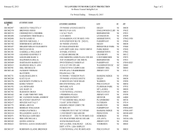
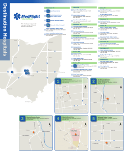
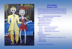
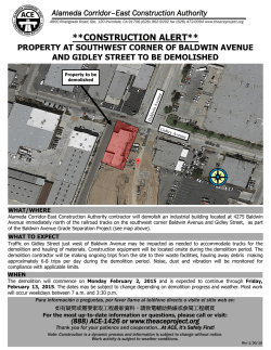
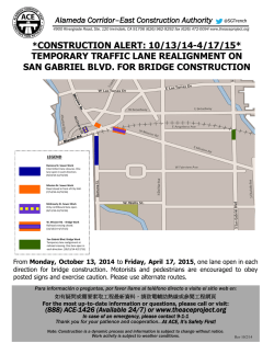
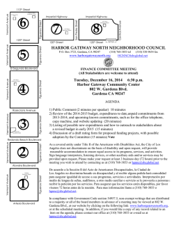
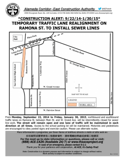
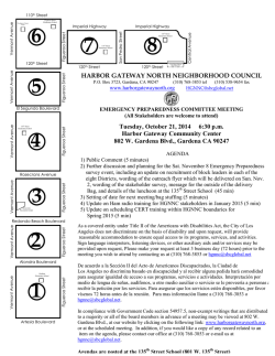
© Copyright 2026