
Download the ACCSEAS Baseline and Priorities Report
ACCSEAS Baseline and Priorities Report Issue: 3 Issue Status: Approved Issue Date: 02/02/2015 Lead Author Reviewer Approved for Release Name: Thomas Porathe (up to Version 2);Jan-Hendrik Oltmann (from Version 3) Name: Transnational Project Co-ordination Group Name: Project Steering Committee Job Title: WP4 Stream 4.1 Co- Job Title: Transnational Project Co-ordination Group Job Title: Project Steering Committee Partner: Federal Waterways and Shipping Administration, Germany Partner: All Partner: All Signature: Jan-Hendrik Oltmann Signature: pp. Alwyn Williams Signature: pp. Alwyn Williams ordinator ACCSEAS Baseline and Priorities Report Issue: 3 Approved Executive Summary This is the first report in the EU INTERREG IVb North Sea Region Programme project, ACCSEAS (Accessibility for Shipping, Efficiency Advantages and Sustainability). This report describes the baselines of the ACCSEAS project and the necessary prioritizations made. The report is the result of investigations based on literature search, and contacts with different stakeholders. In Chapter 1, the current maritime status of the North Sea Region (NSR) is presented, which is one of the world’s busiest shipping areas with more than 130,000 ships passing in and out through the English Channel in 2012. (In the figure below, the numbers within brackets are the 2012 figures for ships passing the red segments.) Due to global warming, the EU has made the decision to reduce the emission of greenhouse gases by 80% in the period to 2050. The EU also aims to get 20% of its energy from renewable sources by 2020. Renewable sources include wind, solar, hydro-electric and tidal power as well as geothermal energy and biomass. Today it is wind energy that is the greatest focus of attention. On top of this, Germany has decided to close its nuclear power industry by 2022 and replace it with renewable energy. At the moment, plans are in place for a massive development of off-shore wind turbines in the NSR, where Germany and the UK are leading the largest scale of development. Looking at these plans, ACCSEAS has found that large areas of the NSR will be utilized for wind energy in 2020+. These areas are the green polygons in the map below. (Existing off-shore wind energy areas today are so small that they are hardly seen on a map of this scale.) At the same time as massive development of wind power, there is an on-going increase in the number of ships in the area. This is presented in Chapter 2 of this report: “The NSR tomorrow.” Based on prognosis by the Lloyds’s Register and the International Union of Marine Insurance, a 50% increase is foreseen in the number of ship movements in the NSR by 2020+. This increase is reflected in the map above, shown as the numbers not in brackets. ACCSEAS Project Page 2 of 126 ACCSEAS Baseline and Priorities Report Issue: 3 Approved A growing number of ships and an increasing number of wind turbines will lead to a competition of available marine space. Although some of the wind energy will be located in areas that are not usable for ships, from the ACCSEAS analysis of information, a large part of the development will be in areas where present day shipping routes exist. The validity of different forecasts of the future can always be questioned. Will the wind turbine areas really be built according to plans? Will shipping really grow as the prognosis suggests? Looking into the future, it is only possible to extrapolate from the present situation and use assumptions based on information from respected international sources. Unknown, maybe paradigmatic, shifts could be unforeseeable. The very idea of the first part of this report is to open stakeholders’ eyes to a possible future conflict in the open sea space of the NSR, and the engagement of the marine and maritime stakeholder communities – including users, service providers and authorities – may in turn bring about changes. The demand for sustainability, expressing itself e.g. by the advent of renewable energy plants, is there to stay. Renewable energy plants at sea are there to stay. And so is shipping. Harmonised coexistence can be promoted by good planning of the use of available marine space, i.e. by Marine Spatial Planning, by incorporating sustainability into the Maritime Transportation System and by methodological, operational and technological innovations. In the international domain, namely at the International Maritime Organisation (IMO), these aspects have been addressed, namely by the proposal of the IMO Secretary General on the occasion of the World Maritime Day 2013 to create a Sustainable Maritime Transportation System (SMTS) and by the e-Navigation strategy of IMO which is now about, due to the adoption of the “IMO e-Navigation Strategy Implementation Plan (SIP)” by IMO in November 2014, to enter a degree of implementation intensity of that plan. Both developments are also baselines for ACCSEAS, and ACCSEAS has committed itself from the outset to support such international developments, in particular the IMO’s e-Navigation strategy, which is demonstrated in Chapter 3 in both cases. Therefore, the proposed SMTS and the e-Navigation Strategy have both been analysed in depth as to their potential implications for ACCSEAS with a view for their future implementation in the NSR at large. The conclusion is that since it was possible to demonstrate that ACCSEAS, as a regional project – regional both from a global point of view as well as from an European point of view –, contributes to the SMTS and IMO e-Navigation strategy as demonstrated, the reverse is also true: It is thereby demonstrated that the SMTS and the IMO e-Navigation strategy can be applied to relevant regions, like the NSR with its specific challenges for navigation and maritime traffic, e.g. by employing the ACCSEAS approach. Hence, the implementation of the IMO’s e-Navigation strategy in NSR by ACCSEAS may also serve as a reference e-Navigation project for other regions globally. Turning towards the necessary prioritizations Chapter 4 introduces 14 so-called “candidate solutions” from the e-Navigation paradigm for further investigation in various ways throughout the project as follows: 1. 2. 3. 4. Maritime Service Portfolios (MSPs) for the NSR (NSR-MSPs) Route Topology Model (RTM) “Maritime Cloud” as an underlying technical framework solution Innovative Architecture for Ship Positioning comprising both Multi Source Positioning Service and infrastructure to provide Resilient PNT (such as R-Mode and eLoran) 5. Maritime Safety Information/Notices to Mariners (MSI/NM) Service 6. No-Go-Area Service 7. Tactical Route Suggestion Service (shore/ship) 8. Tactical Exchange of Intended Route (ship/ship and ship/shore) 9. Vessel Operation Coordination Tool (VOCT) 10. Dynamic Predictor (for tug boat operations) 11. Augmented Reality / Head-Up-Displays (HUDs) ACCSEAS Project Page 3 of 126 ACCSEAS Baseline and Priorities Report Issue: 3 Approved 12. Automated FAL Reporting 13. Harmonized Data Exchange – Employing the Inter-VTS Exchange Format (IVEF) 14. Real Time Vessel Traffic Pattern Analysis and Warning Functionality for VTS The evaluation criteria of those candidate solutions during the ACCSEAS project is given in Chapter 5 as well as the description of the evaluation methods, namely architectural analysis, live environment ACCSEAS testing in a Test Bed in the southern North Sea, and simulations at various ship-handling simulators of ACCSEAS partnership. Chapter 6 concludes this report with an overview of the report structure for ACCSEAS where the relevant results will be reflected. Together, the reports and descriptive documents form a well-structured suite of ACCSEAS documents and other deliverables which form a lasting legacy of the project as given in the following figure. ACCSEAS Baseline and Priorities Report ACCSEAS NSR GIS database ACCSEAS e-Navigation Architecture Report Multi-Source Positioning Sensor Service Description North Sea Region Route Topology Model Description R-Mode Feasibility Study Milestone Reports 1-5 Other Service Descriptions Demonstrators at ACCSEAS Test Bed Transferable Best Practice Guide ACCSEAS Final Report ACCSEAS Training Needs Analysis Report ACCSEAS Use of Simulators in e-Navigation Training and Demonstration Report A Plan for the Sustainability and Harmonisation of e -Navigation in the North Sea Region (e-Navigation Sustainability Plan) It should be noted, that the expected results of ACCSEAS span several domains, namely the policy domain (compare e.g. the “e-Navigation Sustainability Plan”), the humans factor domain (compare e.g. the “ACCSEAS Training Needs Analysis Report”), the system architecture domain (compare e.g. the “ACCSEAS e-Navigation Architecture Report”) and the technology domain (compare e.g. the various technical descriptions, the ACCSEAS Test Bed and the “ACCSEAS Final Technical Report”). ACCSEAS Project Page 4 of 126 ACCSEAS Baseline and Priorities Report Issue: 3 Approved Contents 1 The North Sea Region Today ......................................................................................... 9 1.1 Maritime Regional Overview ................................................................................... 9 1.2 Today’s Shipping Movements in the NSR ............................................................. 11 1.3 Perspective on NSR Safe Maritime Accessibility ................................................... 12 1.4 Accessibility Assumptions for Key Ports and Sea Areas ....................................... 13 1.4.1 Port of Rotterdam .......................................................................................... 13 1.4.2 Port of Antwerp .............................................................................................. 13 1.4.3 Port of Hamburg ............................................................................................ 14 1.4.4 Straits of Dover .............................................................................................. 14 1.4.5 Kattegat: ........................................................................................................ 15 1.4.6 Kiel Canal ...................................................................................................... 16 1.5 2 Risk analysis ......................................................................................................... 19 1.5.1 IWRAP, method, assumptions and data......................................................... 19 1.5.2 Colour coding the results ............................................................................... 19 1.5.3 IWRAP model for the northern part of the North Sea ..................................... 20 1.5.4 Results from the IWRAP analysis – North Sea, Northern Part ....................... 21 1.5.5 IWRAP model for the southern part of the North Sea ..................................... 22 1.5.6 Actual collision numbers used to calibrate the model ..................................... 23 1.5.7 Argument for perceiving the entire Dutch coast as a collision hotspot ............ 25 The North Sea tomorrow .............................................................................................. 27 2.1 The picture of the North Sea Region tomorrow ..................................................... 27 2.2 Ship traffic 2020+ .................................................................................................. 31 2.3 Conclusion and outlook: Growing safety concerns for North Sea shipping traffic to be addressed by e-Navigation .............................................................................................. 32 3 ACCSEAS’ wider context - The relationship of ACCSEAS with international and European developments ..................................................................................................................... 35 3.1 EU Context of ACCSEAS...................................................................................... 35 3.1.1 European Regional Development Fund and INTERREG IVB......................... 35 3.1.2 Previous Relevant INTERREG Projects ......................................................... 36 3.1.3 Marine Spatial Planning and Environmental Issues ....................................... 37 3.1.4 EU Maritime Transport ................................................................................... 40 3.1.5 Policy link between EU and International levels ............................................. 45 3.2 ACCSEAS in support of IMO Secretary General’s proposed Sustainable Maritime Transportation System (SMTS) ....................................................................................... 46 3.2.1 The existing global Maritime Transportation System ...................................... 46 3.2.2 Transforming the MTS into a Sustainable Maritime Transportation System (SMTS) 47 ACCSEAS Project Page 5 of 126 ACCSEAS Baseline and Priorities Report Issue: 3 Approved 3.2.3 ACCSEAS general contributions to the envisaged SMTS .............................. 51 3.2.4 The “IMO e-Navigation strategy” as a contribution to the SMTS .................... 51 3.3 3.3.1 The “IMO e-Navigation strategy” .................................................................... 55 3.3.2 The “IMO e-Navigation Strategy Implementation Plan (SIP)” ......................... 58 3.3.3 The “Seven Pillars of e-Navigation”................................................................ 59 3.3.4 ACCSEAS general contributions to the IMO e-Navigation strategy ................ 61 3.4 4 ACCSEAS in support of IMO’s e-Navigation Strategy ........................................... 55 ACCSEAS’ means to advise decision makers....................................................... 63 Candidate solutions ...................................................................................................... 65 4.1 Identifying tools for candidate solutions based on an analysis of the present situation in the North Sea Region .................................................................................................. 65 4.1.1 Identifying tools for candidate solutions based on an analysis of the future situation in the North Sea Region ................................................................................. 68 4.1.2 Conclusion ..................................................................................................... 69 4.2 Candidate Solution “Maritime Service Portfolios (MSPs) for the North Sea Region (NSR-MSPs)”................................................................................................................... 69 4.3 Candidate Solution “Route Topology Model (RTM)” .............................................. 71 4.4 Candidate Solution “Maritime Cloud” as an underlying technical framework solution 71 4.5 Candidate Solutions in the Context of an Innovative Architecture for Ship Positioning 72 4.5.1 The User Need and User Requirements for Resilient PNT............................. 72 4.5.2 Resilient PNT technical solutions on-board and ashore ................................. 74 4.5.3 Candidate Solution “Multi Source Positioning Service (MSPS)” ..................... 75 4.5.4 Candidate Solution “R-Mode at MF and AIS” ................................................. 76 4.6 Candidate Solution “Maritime Safety Information/Notices to Mariners (MSI/NM) Service” ........................................................................................................................... 76 4.7 Candidate Solution “No-Go-Area Service” ............................................................ 78 4.8 Candidate Solution “Tactical Route Suggestion Service (shore/ship)” ................... 79 4.9 Candidate Solution “Tactical Exchange of Intended Route (ship/ship and ship/shore)” 80 4.10 Candidate Solution “Vessel Operations Coordination Tool (VOCT)” ..................... 80 4.11 Candidate Solution “Dynamic predictor (for tug boat use)” .................................... 81 4.11.1 Introduction .................................................................................................... 81 4.11.2 Content of the dynamic predictor information to be exchanged ...................... 82 4.11.3 Test method and evaluation ........................................................................... 82 4.11.4 Other ideas .................................................................................................... 83 4.12 Candidate Solution “Augmented Reality and Head Up Display” ............................ 83 4.13 Candidate Solution “Automated FAL Reporting” ................................................... 85 ACCSEAS Project Page 6 of 126 ACCSEAS Baseline and Priorities Report Issue: 3 Approved 4.14 Candidate Solution “Harmonized Data Exchange Service – Employing the Inter-VTS Exchange Format (IVEF)” ................................................................................................ 85 4.15 Candidate Solution “Real Time Vessel Traffic Pattern Analysis and Warning Functionality for VTS” ...................................................................................................... 85 4.16 5 Summary of ACCSEAS candidate solutions ......................................................... 86 The evaluation of the Candidate Solutions ................................................................... 87 5.1 Evaluation criteria ................................................................................................. 87 5.2 Physical Test-bed location .................................................................................... 87 6 The structure of ACCSEAS reports .............................................................................. 89 7 Abbreviations ............................................................................................................... 91 8 References ................................................................................................................... 93 9 List of Appendices ........................................................................................................ 94 APPENDIX A – Categorized overview of the ACCSEAS GIS .............................................. 95 APPENDIX B – Passage Line Statistics ............................................................................ 101 APPENDIX C – Table 3-7 “Tasks” and “Task actions” for solution implementation according to the IMO e-Navigation Strategy Implementation Plan (SIP) ............................................ 117 ACCSEAS Project Page 7 of 126 ACCSEAS Baseline and Priorities Report Issue: 3 Approved Document Disclaimer Document is uncontrolled when removed from iManage (either electronic or printed) Document Information Project Title ACCSEAS Work Package No. 3 Document Title ACCSEAS Baseline and Priorities Report Description Date 02/02/2015 Lead Author Thomas Porathe (up to Version 2);Jan-Hendrik Oltmann (from Version 3) Lead Author’s Contact Federal Waterways and Shipping Administration Information Waterways and Shipping Agency, Northern Region Office 24106 Kiel, Germany Contributing Author(s) Thomas Porathe, Mads Bentzen, Lea Kuiters, Oscar Lexell, JanHendrik Oltmann, Pieter Paap, Stephan Procee, Pawel Ziegler, George Shaw, Alwyn Williams, Paul Williams, Michael Baldauf, Ole Bakman Borup, John Morten Klingsheim iManage Location 27655 Circulation 1. Client 2. Project Files (i-manage) 3. Transnational Project Co-ordination Group 4. Project Steering Committee ACCSEAS Project Page 8 of 126 ACCSEAS Baseline and Priorities Report Issue: 3 Approved 1 The North Sea Region Today Figure 1-1. The North Sea Region (NSR) With the eastern part of UK, Belgium, The Netherlands, the northern part of Germany, Denmark, Norway and the western part of Sweden. Also the Skagerrak and Kattegat as well as the Sounds and the south western part of the Baltic Sea are included in the NSR. 1.1 Maritime Regional Overview The North Sea Region (NSR) is an integral part of the European Union, Western Europe and Scandinavia, with extensive geographic coverage of the whole of the North Sea, the western area of the Baltic Sea and the crucial maritime links between the two Seas. The NSR is virtually surrounded by land on three sides with restricted access to the north guarded by the Norwegian coast and the islands of the Shetlands and Orkneys. The North Sea itself can be considered topologically as a square-sided sea basin, with the Wash in the south west and the Elbe to the south east. To its south entry, the North Sea narrows along the Southern Bight coasts of the Netherlands, Belgium and UK. The southern extremity of the North Sea is marked by the Dover Straits, where the arm of the Channel extends out into the Atlantic. On the eastern flank, the region links to the Baltic through the deep channel of the Skagerrak ACCSEAS Project Page 9 of 126 ACCSEAS Baseline and Priorities Report Issue: 3 Approved between Denmark, Norway and Sweden before meeting the shallower Kattegat. Typically, the North Sea decreases in depth from 100-200 metres in the North to 25- 55 metres in the south although there are variations in depth over the Viking and Dogger Banks, Norwegian Trench and the colourfully named Devil’s Hole. The NSR is one of the busiest shipping areas and most industrially developed areas of the World. Production and manufacturing complexes are clustered around three sides of the North Sea basin. The sea area itself has seen the growth in oil and gas facilities since the 1970s and in more recent years there has been an expansion into renewable energy with the use of wind turbines. All these activities are reliant on the movement by ship of raw materials, finished goods, supplies and construction equipment, along with personnel and passengers. By the end of the 1980s it was estimated that some half a million voyages by ship were taking place annually within the southern North Sea. Not only did these include voyages originating from outside the NSR, but also movements within the NSR of what is now called Short Sea Shipping: port to port movement within the NSR of traffic typified by ferries and RO-RO vessels. In 2010, EU ports handled an estimated 3.6 billion tonnes of goods, a rise of 5.7% on the previous year. The EU trade in 2010 was dominated by the North Sea ports, which handled 38.3% of maritime goods traded through all EU coastal regions, with the Netherlands overtaking the United Kingdom (UK) as the largest maritime freight transport country in the EU during that year. The Port of Rotterdam alone accounted for more than 10% of the total EU tonnage in 2010. Approximately 15% of the total tonnage of goods handled in EU ports was in Netherlands, with the UK ports being the second largest handler of goods in and out of the EU (14.1%). The three largest EU ports, both in terms of gross weight of goods and volume of containers handled, are all in the NSR. These are Rotterdam, Antwerp and Hamburg. However, port activity in 2010 was still lower than the previous high in 2005. This reflects the economic downturn in 2008/9. NSR countries such as Belgium, the Netherlands and Sweden showed significant increases in the tonnage of goods handled in 2010, compared with 2009. Denmark, however, showed a marked decrease of -3.9% in the same period, demonstrating that there are marked variations across the NSR as a whole. This variation can be reflected in the type of goods being transported during the recession. For example, the total tonnage of goods outwards from Norway in 2010 grew by 7% over the previous year, mainly due to the increase in volumes of ores and dry bulk goods. However, this overall increase was accompanied by a decrease of nearly 14% in the outward transport of crude oil. The types of goods handled also vary across the NSR. Dutch ports handle the largest tonnage of liquid bulk goods (265 million tonnes) in the EU. Five of the top ten EU container ports are located within the NSR: Rotterdam, Antwerp, Hamburg, Bremerhaven and Felixstowe, with container transport being dominant in Belgian and German ports. Approximately 1.8 billion tonnes, 62%, of goods transported by sea in the EU was via Short Sea Shipping in 2010. Seven of the EUs top ten Short Sea Shipping ports are located within the NSR: Rotterdam, Antwerp, Hamburg, Immingham, Gothenburg, London and Amsterdam. Nationally, within the NSR, ports in Denmark and Sweden handle significant movements of RO-RO goods in terms of their overall port handling, although the UK recorded the largest tonnage of RO-RO movements in the EU (96 million tonnes), primarily due to the short sea shipping route from Dover (Eurostat, 2013). The importance of these ports to the EU as a whole and to the economic well-being of the NSR should not be underestimated. This economic value underlines the need to maintain access to and from the region’s ports. The region of Groot-Rijnmond in the Netherlands, which contains the port of Rotterdam, in 2010 handled the largest quantity of maritime freight in the EU (405 million tonnes), two and a half times that of the second ranked region, Antwerpen (160 million tonnes) and nearly four times that of the third ranked region, Hamburg (105 million tonnes). All three regions are located within the NSR. ACCSEAS Project Page 10 of 126 ACCSEAS Baseline and Priorities Report Issue: 3 Approved 1.2 Today’s Shipping Movements in the NSR Figure 1-2 shows the traffic density of vessels in the NSR based on vessel positions reported throughout 2012 by the Automatic Identification System (AIS). Also shown are the number of vessel movements across selected line segments in the region, counting the total number of ships crossing the line in 2012. In the south, an annual total of 131,444 passages were recorded through the Channel. This equates to one ship passing through the Channel approximately every 4 minutes, 24 hours a day, 7 days a week. Combined with the number of Short Sea Shipping movements in this area, such as the cross-Channel ferries, this gateway to the NSR is recognised as the busiest shipping area in the world and critical to the economic sustainability of the NSR and the EU as a whole. Several other gateways for maritime trade in the region also exhibit high levels of traffic. The area in the south off the coasts of Belgium, Netherlands and Germany provides vital access for vessels to the important ports of Rotterdam, Antwerp, IJmuiden/Amsterdam, Hamburg and Bremerhaven among others. A total of 58,412 vessel passages crossed a line segment annually in this area. A similar number of vessels (54,448) passed in and out of the Skagerrak between Denmark and Norway connecting to the Baltic Sea. Together with the large number (29,441) of annual passages through the Kiel Canal, these constricted sea and water ways provided access to the ports of Gothenburg and beyond into the Eastern Baltic. Shipping densities are lower in the north of the region, but with significant numbers transiting the coast of Norway on economically crucial routes, which can be expected to increase in numbers and importance as the Arctic ice recedes and the northern passage to the Far East becomes available to shipping year round in the coming decades. Figure 1-2. Ship traffic density in the NSR (2012). The labels show the total number of ships passing each line from both directions during 2012.The red colour gradient shows the relative density of shipping in the NSR. The empty area in the middle of the North Sea is an area without AIS coverage (it does not mean that there is no traffic). For details compare Appendix B. ACCSEAS Project Page 11 of 126 ACCSEAS Baseline and Priorities Report Issue: 3 Approved Figure 1-3. High shipping density areas (2012). “High traffic density areas” are defined here as cells of 400mx400m where AIS messages from more than 180 vessels were received over the year. 1.3 Perspective on NSR Safe Maritime Accessibility Shipping activity in the region demonstrates the need to maintain the safety of navigation to ensure access to and from the ports, particularly in the southern North Sea and the connections to the Baltic Sea (Skagerrak and Kiel Canal). Unfortunately maritime history shows that such improvements in safety have been punctuated by shipping accidents. 1967 saw the introduction of a voluntary Traffic Separation Scheme (TSS) for west bound ships entering the Dover Straits. However, following the loss of the Texaco Caribbean and the subsequent collisions and loss of life in January 1971 (CEDRE, 2006), the scheme was made mandatory under the International Regulations for Preventing Collisions at Sea (COLREGS) in 1972. Indeed, the Dover Straits became the first approved TSS in the World (MCA, 2013). By the end of the 1980s, the scheme had been extended from France and UK areas into the waters of Belgium and the Netherlands; with a second IMO approved TSS in the German Bight. Both TSS are in operation today, so it is fitting that the area will form part of proposed focus area for the e-Navigation Test Bed being developed by the ACCSEAS project. Effective from 1 August 2013, shipping routes for the very busy area of the North Sea off the Netherlands were amended, and a TSS was established for the approach to the port of IJmuiden. Traffic routes were located further out from the coast, with fewer crossing routes, leading to less congestion. Anchorage areas were moved and some reorganisation took place around obstacles such as drilling platforms. The plan was prepared in close cooperation with stakeholders in the region, such as the licence holders of wind parks, the ports authorities of Rotterdam and Amsterdam, Dutch Coastguard, the Hydrographic Service, the Pilots Service, ship-owners, fishery and drilling organisations. ACCSEAS Project Page 12 of 126 ACCSEAS Baseline and Priorities Report Issue: 3 Approved Segregation of vessels does not operate across the whole of the North Sea, nor does it apply to all vessels. Ferry, RO-RO and other Short Sea Shipping traffic regularly cross shipping lanes. The collisions involving the Mont Louis (1984), Anna Broere (1998), together with the fire on the Multitank Ascania (1999), indicate not only the risk of collision in the area, but the threat posed by hazards to civil protection and resulting pollution. It should be noted that approximately 22% of recorded incidents involving Hazardous and Noxious Substances (HNS) in EU waters have occurred in the North Sea (EMSA, 2007). Similarly, the collision and sinking of the Tricolor (2002) and Baltic Ace (BBC, 2012) demonstrate that even in an age of improved Aids-to-Navigation (AtoN), the risk of collision in the crowded waters of the North Sea is ever present. The growth in the use of offshore wind turbines throughout the region highlights the potential risk of collision with passing ships. The renewable industry has recognised the potential safety and environmental impact of a direct collision between a vessel and a wind turbine. However, insufficient transnational consideration has been given across the NSR to the impact of multiple developments of wind turbines, so-called wind farms, concentrating ships into narrower shipping lanes and restricting a vessel’s room to manoeuvre or sea room. The growth in wind turbines across the NSR corresponds to an increase in larger vessels with restricted manoeuvrability, such as modern container vessels entering the Southern North Sea. The challenges for safe and efficient maritime accessibility, given the growth in future shipping, offshore renewable energy installations, environmentally sensitive areas, fisheries, aquaculture, leisure and many other elements competing for limited sea space in the NSR, are discussed in Chapter 2. 1.4 1.4.1 Accessibility Assumptions for Key Ports and Sea Areas Port of Rotterdam The EECV-quay of the port has a draft of 24 m, making it, along with the Terminal of Ponta da Madeira in Brazil, one of only two available mooring locations for the largest bulk cargo ship in the world, the iron ore bulk carrier MS Berge Stahl when it is fully loaded. The ship's draft of 23 m leaves only 1 metre of Under Keel Clearance (UKC), therefore it can only dock in a restricted tidal window. Such ships must travel in the Eurogeul, the deep-water route into Rotterdam. (Port of Rotterdam. 2013) The largest container vessel currently operating has a capacity of around 16,000 TEU (Twenty Foot Equivalent unit based on a single 20ft container); but even larger vessels up to 18,000 TEU and 22,000 TEU are currently being built and planned. The trend in vessel sizes is discussed further in Chapter 2. 1.4.2 Port of Antwerp Less than a month after the MSC Emanuela entered the history books as the container ship with the greatest draught ever on the river Scheldt, the MSC Daniela has beaten its sister ship’s record. On Friday afternoon the ULCS (Ultra-large Container Ship) entered the port of Antwerp without problem, with a record draught of no less than 15.25 m. After passing through the Berendrecht lock the Daniela headed for the MSC Home Terminal in the Delwaide (Port of Antwerp, 2013). The size of seagoing ships calling at Antwerp is steadily increasing. In 2011 the average gross tonnage rose above 20,000 GT for the first time ever. The freight capacity has also increased markedly, with more and more Ultra Large Container Carriers (ULCCs) of 10,000 TEU or more entering service. The record is currently held by the Maersk shipping company which calls with vessels having an LOA of nearly 400 m and a capacity of as much as 15,500 TEU. The recent deepening of the river Scheldt was crucially important for the port of Antwerp, permitting tide-independent navigation with a draught of 13.10 m. The maximum draught for ships sailing upriver is now ACCSEAS Project Page 13 of 126 ACCSEAS Baseline and Priorities Report Issue: 3 Approved 15.56 m for destinations behind the locks and 16.00 m for destinations on the river and in the Deurganck dock. Downriver, ships can leave from behind the locks with draughts of up to 14.50 m and from on the river or in the Deurganck dock with draughts of up to 15.20 m. Shipping companies are now choosing to send fewer but larger vessels, as having fewer port calls helps to keep transport costs down (Port of Antwerp, 2013). 1.4.3 Port of Hamburg The Elbe River flows 1,165 km from its source to the North Sea. The mouth of the river has a breadth of about 15 km. About 870 km of the river are navigable. The stretch between Hamburg and the sea is called the Lower Elbe, upriver from Hamburg is the Upper Elbe. The distance from the approach buoy to the Port of Hamburg is about 115 km or 70 sea miles. Sailing up the estuary, ships pass by Cuxhaven, Brunsbüttel, Glückstadt and Stade, before they reach the harbour limits near Tinsdal. The Elbe River has a depth of 16.3 m at high tide. Ships with a maximum draught of 12.8 m can enter or clear the port irrespective of tides. Making use of high tides, ships of up to 15.1 m draught can sail up the Elbe. The largest ship to call at the Port of Hamburg thus far was the Paradise N, which can carry a payload of 322,398 metric tons (Port of Hamburg, 2013). 1.4.4 Straits of Dover In UK, Lord Kennet asked Her Majesty's Government: “What, in their view, is the maximum draft for ships safely to navigate the Dover Strait?” The Parliamentary Under-Secretary of State, Department of Transport (Lord Brabazon of Tara) stated: “This depends on a number of factors, for example the height of the tide at the time, the required navigable width and the underkeel allowance which needs to be made; and it is for the master of a ship to decide in the prevailing circumstances and in the light of such factors whether he can safely take his vessel through what is an international strait. However, I share my predecessors' view that ships of up to 68 foot (20.7 m) draught can safely navigate the Dover Strait at low water, but that the regular passage of ships of more than 68 foot draught creates an increased risk of a serious accident in those waters.” (Hansard, 1986) The Netherlands Hydrographic Service publishes a Deep Draft Planning Guide covering the Deep Draft Route through Dover Strait to Rotterdam for vessels with drafts over 20.7 m. However, the contents of the guide are not necessarily endorsed in every detail by the UK authorities: Vessels with drafts up to 22 m, and up to 22.6 m in favourable conditions, can use this Deep Draft Route. However, the recommended UKCs should be taken into consideration (NGIA, 2010). ACCSEAS Project Page 14 of 126 ACCSEAS Baseline and Priorities Report Issue: 3 Approved Figure 1-3. Traffic Densitiy in the southern NSR. The symbols represent the location of 1,236 vessels of different types over international and inland waters at 10.40 on 8 October 2012 (Ships in the Rotterdam area – green box – is not represented) Source: http://www.marinetraffic.com. 1.4.5 Kattegat: The Kattegat is the sea area between the Swedish west coast and the Danish east coast, north of Sjaelland and south of a line from Skagen (Skaw) on the northern tip of Denmark and due east. It is a shallow sea, particularly on the west side, trafficked by over 43,000 ships in 2012, almost all of which rounded the northern tip of Denmark at Skagen creating a pinch point of ships coming from the North Sea, turning south into Kattegat and ships northbound from Kattegat turning west into the North Sea trying to squeeze as close to the buoy as possible. Most of the traffic down through Kattegat is destined for ports in the Baltic Sea or further into the Gulf of Finland or Sea and Bay of Bothnia through the two major narrows of Oeresund (the Sound – some 30,000 ships 2012) or the Great Baelt (almost 20,000 ships 2012). The way through the Sound is somewhat shorter, but only allows ship with a controlling depth of 7.7 m, while the Great Baelt allows ships with a controlling depth of 11 m. The major fairway through Kattegat is the “Route T” leading from Skagen, east of the islands of Laesoe and Anholt, to the Sound or Great Baelt. On the west side, along the coast of Jylland is the narrow and winding “Route B” with a more limited control depth than Route T. ACCSEAS Project Page 15 of 126 ACCSEAS Baseline and Priorities Report Issue: 3 Approved Figure 1-4. Location of the Kattegat. The Kattegat is the sea area between Sweden and Denmark and one of the entrances to the Baltic Sea (besides the Kiel Canal). The name is derived from Dutch meaning “narrow entrance of the cat”. 1.4.6 Kiel Canal The Kiel Canal, or Nord-Ostsee-Kanal (NOK) in German, is the busiest artificial waterway globally. The Kiel Canal provides an important connection to the Baltic Sea area by a cut through the Jutland peninsula in the German state of Schleswig-Holstein (compare Figure 15). It has thus rightly been labelled a Motorway of the Sea (MoS). Figure 1-5. Location of the “Motorway of the Sea” Kiel Canal (German: Nord-Ostsee-Kanal) ACCSEAS Project Page 16 of 126 ACCSEAS Baseline and Priorities Report Issue: 3 Approved The Kiel Canal shortens the distance between the North Sea and the Baltic Sea considerably (Figure 1-6), which in turn results in savings of time, fuel, and costs as well as in less emissions of carbon dioxide. Figure 1-6. Shortening the distances between North Sea and Baltic Sea by the Kiel Canal compared with the passage around Skagen via Great Belt or Oeresund; in km. At present, the Kiel Canal exhibits the following features: Length: 98.637 km Width: 162 m at the water surface, 90 m on the bottom (adapted areas) in the western part of the Canal and 102 m at the water surface 44 m, on the bottom (eastern part). Depth: 11 m Sidings: Several sidings along the Canal, i.e. stretches of the Canal with a widened profile, allow encounter of vessel which are not permitted to meet within other parts of the Canal. Two assemblies of four locks each are situated at either end of the Canal, i.e. at Brunsbüttel interfacing to the Elbe estuary and thereby to the North Sea as well as at Kiel interfacing to the Baltic Sea. The locks and their turn-around, by their very nature, are pacemakers for the traffic flow through the Kiel Canal. The two large lock chambers at Brunsbüttel are almost 100 years old and are increasingly demanding in terms of maintenance and repair. To avoid any major congestion for the vessel traffic flow through the Kiel Canal during a planned lengthy repair process, a fifth lock chamber will be built in Brunsbüttel. Work has started on that newbuilding. The transport volume through the Kiel Canal has doubled since 2000, while the number of larger vessels (i.e. those vessels being assigned to the Kiel Canal Traffic Groups 4 to 6) has multiplied by factor three, still growing (Figure 1-7). ACCSEAS Project Page 17 of 126 ACCSEAS Baseline and Priorities Report Issue: 3 Approved Figure 1-7. Number of passages (green) through the Kiel Canal compared with the average gross tonnage of vessels (BRZ, red) The traffic through the Kiel Canal is managed subject to a Traffic Organisation Service (TOS) operated by the Kiel Canal Vessel Traffic Services (VTS) centre in Brunsbüttel. To this end a sophisticated size class scheme for vessels (i.e. the Kiel Canal Traffic Groups) is employed in combination with a way-time-diagram (Figure 1-8). Figure 1-8. Traffic Organisation Service at the Kiel Canal VTS centre in Brunsbüttel ACCSEAS Project Page 18 of 126 ACCSEAS Baseline and Priorities Report Issue: 3 Approved 1.5 Risk analysis When designing future shipping lanes it is important to be able to foresee the risks involved with different designs. For this reason the IALA Waterway Risk Analysis Program (IWRAP), probabilistic collision and grounding analysis tool has been developed (IALA, 2012). Using a theoretical model containing the number and types of ships, the orientation of shipping lanes and grounding areas, etc. a theoretical risk probability can be calculated. In order to validate this method an IWRAP analysis has been performed on 2011 data, which we then will correlate with statistics of present groundings and collisions. 1.5.1 IWRAP, method, assumptions and data IWRAP can estimate the number of expected collisions and groundings in a given area. Using AIS data it can set up a collision/grounding model of an area. The sailing routes are represented by a number of legs. To each leg a distribution of how the ships sails is estimated. The number of ships sailing in each direction of the leg is also found. The general idea in the model is to calculate how many collisions and groundings will occur if all the ships sail straight ahead without making any evasive manoeuvres. This gives the number of geometrical collisions and groundings. Ships do not sail blindfold, but some actually do. About 1 or 2 in 10,000 operations are not performed the way they should. This is called the causation factor. The total number of collisions is the number of geometrical candidates multiplied by the causation factor. So, one part of IWRAP is geometry and statistics and the other part is the human factor. The method has been extensively tested and found to estimate the number of collisions and groundings close to the observed numbers. The model presented below does not include the rivers, estuaries, harbours and surroundings of these. The data used for the model are AIS data. 5+2+3 days in every month have been collected giving 10x12 days of AIS data. The number of ships is then multiplied by a factor 3.04 to get one year. IWRAP analyses the data set for gaps and comes up with a factor of 3.06. The models have been calibrated using historical collision data from 2010 and 2011. For the northern model the total number of collisions is calculated to 0.57 per year or one every two years. For the southern model the total number of collisions is calculated to 4.2 per year. Fishing vessels not fitted with AIS have not been included in the present analysis. Therefore, IWRAP tends to underestimate the number of collisions, because fishing vessels sailing in a more random pattern are not included. IWRAP is able to include them if fishing areas and the number of fishing vessels were defined. The model would let the fishing vessels crisscross the area and would then estimate how many collisions with regular traffic would happen. To that end the places of the fishing areas need to be known, as well as how many fishing vessels operate there and how many days a year they are present. In areas with many fishing vessels, like in the NSR, this could account for as much as half of the collisions. Because of the many fishing ships in the NSR this should be considered. 1.5.2 Colour coding the results The results of the IWRAP analysis can be shown as colour coded legs and waypoints (compare Figures 1-12ff). The default colour coding is as quantiles as shown below. But the results can also be colour coded as percentage of the total collisions, such that the blue colour could represent 10 % of the collisions and the yellow colour could be 1 % of the collisions. ACCSEAS Project Page 19 of 126 ACCSEAS Baseline and Priorities Report Issue: 3 Approved 95 % of the legs are below this 75 % of the legs are below this 50 % of the legs are below this The lowest 10 % of the legs In the IWRAP model for the NSR is split into a southern model and a northern model. The reason for splitting is partly to reduce the size of the separate calculations but also due to the fact that the areas are quite different in nature. In the southern part there are a lot of vessels sailing close to each other. In the northern part the ships are generally sailing farther apart. 1.5.3 IWRAP model for the northern part of the North Sea In Figure 1-9 we can see the northern part of the NSR. There, the traffic density map depicts the number of ships, where red is the areas with heavy traffic and yellow is areas with less traffic. In the middle of the North Sea we have the area where there is no AIS coverage. Using the available AIS data, a number of shipping lanes (legs) where the majority of the traffic goes (these are the black lines). For each leg the lateral distribution is calculated, that is the number of ships in each direction, and how far to either side of the centre leg they go (see the example in Figure 1-10). Based on the legs and their ship density, as well as the nautical chart with the layout of ground areas, the IWRAP analysis can be performed. Figure 1-9. Modelling the traffic by a number of legs. The legs are reference lines for the lateral distributions that define how far away from the leg the ships are sailing. ACCSEAS Project Page 20 of 126 ACCSEAS Baseline and Priorities Report Issue: 3 Approved Figure 1-10. Four legs with lateral distributions. The north-south legs show a clear traffic separation. 1.5.4 Results from the IWRAP analysis – North Sea, Northern Part In Figure 1-11 the results at each leg are colour coded from yellow to red to blue according to the risk of either collision or grounding. The darker the colour, the higher the risk. The risk has also been calculated in 5 high risk areas. See the text for details on this. Yellow is where the fewest accidents takes place and blue is where most occur. Five areas, where the legs are bluish, are identified that are potential “hotspots”, labelled A, B, C, D and E. A,5% A5% E5% E, 5% 5% D 5D,% B, 55% C, 15% B 55 % C 15 % Figure 1-11. The results of the IWRAP analysis ACCSEAS Project Page 21 of 126 ACCSEAS Baseline and Priorities Report Issue: 3 Approved Area A designates where the ships sailing into the Skagerrak makes a small turn and the traffic begins to narrow. 5 % of the estimated collisions occur here. That is one collision every 20 years. Area B designates the Hamburg, Kiel-Canal and Bremerhaven approaches. This is without comparison where the most collisions will take place, 55 %. That is one collision every second year. Area C is the large TSS north of the Netherlands. 15 % of the estimated collisions occur here. Area D is where the ships coming from the north start to narrow in. Collisions have happened here in the past and it could qualify as a hotspot. 5 % of the estimated collisions occur here. Area E designates the Hull and the Humber approaches. The navigators are most likely aware of the situation here. So it is not really a hotspot. 5 % of the estimated collisions occur here. The colouring is relative and not absolute. So blue or red indicate where most of the collisions take place, not whether there are many collisions. Compared to the southern model, the northern model only accounts for about 15 % of the total collisions in the two models. The total number of collisions is calculated to 0.57 per year or one every two years. About 70 % of the collisions take place north of Germany and the Netherlands. About half of the collisions take place in the waypoints and the other half on the legs as head-on or overtaking collisions. Remember that we have not included the fishing ships. These would probably increase the number of estimated collisions to 1 or 2 per year. The statistics say 2 collisions every year. 1.5.5 IWRAP model for the southern part of the North Sea Figure 1-13 shows the IWRAP model used for the southern part of the North Sea. The results from the IWRAP analysis can be seen in Figure 1-13 below. Figure 1-12. IWRAP model used for the southern part of the North Sea. ACCSEAS Project Page 22 of 126 ACCSEAS Baseline and Priorities Report Issue: 3 Approved D 10 % A5% A B5% B, C 25 % C, Figure 1-13. Results of IWRAP analysis for the southern North Sea. In Figure 1-13 the results are colour coded like in Figure 1-12 and four areas for potential “hot spots” are defined: Area A is the approaches to Felixstowe. Because the navigator is more alert here this probably not a real hotspot. 5 % of the estimated collisions occur here. Area B is probably also approaches to London where the navigators are naturally more alert. 5 % of the estimated collisions occur here. Area C contains the Antwerp approaches; vessel numbers and the fact that the ships are coming from all directions might qualify this as a hotspot. 25 % of the estimated collisions occur here. In Area D the ships are squeezed in to a single leg. 10 % of the estimated collisions occur here. The total number of collisions is calculated to 4.2 per year. Two thirds of these occur in the waypoints. 1.5.6 Actual collision numbers used to calibrate the model EMSA has started in 2010 with an accident statistics, and in 2012 data is available for two years. Two years is not really sufficient for doing statistics. Ten years are more adequate. For the calibration of the IWRAP model in this project, it was assumed that the two years are representative for the situation in the area, however. 1.5.6.1 Northern area In 2010 and 2011 there were two reported collisions in the Northern area’s open water (EMSA, 2011). ACCSEAS Project Page 23 of 126 ACCSEAS Baseline and Priorities Report Issue: 3 Approved Figure 1-14. Actual collisions in 2010 and 2011 in NSR according to EMSA (2011). 1.5.6.2 Southern area In 2010 and 2011 there were nine reported collisions in the southern area’s deep water (EMSA, 2011). In order to calibrate the IWRAP model for the number of collisions, we have to multiply the default causation factors by three (compare Figure 1-16). This implies that the navigators are three times more likely to make a mistake here than in average waterways. Note that the reported collisions vary from source to source. The EMSA report says 5 per year in Dutch open water. Another source says 2 per year. One reason for increasing the causation factors in the southern part this much is that the fishing vessels sailing were omitted with the consequences explained above. If we had included the fishing ships then the causation factors should only be increased by a factor two. Figure 1-15. Causation factors used for the southern part model ACCSEAS Project Page 24 of 126 ACCSEAS Baseline and Priorities Report Issue: 3 Approved 1.5.7 Argument for perceiving the entire Dutch coast as a collision hotspot Figure 1-16. The IWRAP analysis of the southern part of the North Sea again. This time the whole of the Dutch coast is indicated as a risk area. Compare with actual collisions in Figure 1-14 above. If Figure 1-17 is compared with the map of collisions in Figure 1-14 it can be seen that most of the area along the Netherland coast is coloured red and that a number of reported collisions for 2011 and 2012 have taken place here. It could therefore be argued that the entire area marked by the ellipse is a hotspot. ACCSEAS Project Page 25 of 126 ACCSEAS Baseline and Priorities Report Issue: 3 Approved This page intentionally left blank. ACCSEAS Project Page 26 of 126 ACCSEAS Baseline and Priorities Report Issue: 3 Approved 2 The North Sea tomorrow 2.1 The picture of the North Sea Region tomorrow There are many sources of data that provide a picture of competing demands on sea space in the NSR in the 2020+ timeframe. A view such as the planned wind farms of the UK, Denmark, Norway and Germany shown in Figure 2-1 provides a simple introduction to the nature of growth in offshore renewable energy installations. It is immediately apparent that large areas of the North Sea could be dedicated to the use of renewable energy, thereby reducing the sea room for ships to navigate and manoeuvre. When taken together with the trend in the growth in shipping – both in numbers and size of vessels – it is clear that higher density of ships may be forced to navigate in more restricted sea areas. A typical container ship size enables it to transport around 4,000 to 10,000 TEU. The Marco Polo vessel started operation in November 2012 with a capacity of 16,020 TEU; it is 396 m long, 54 m wide, with a draft of 16 m. Even larger vessels up to 18,000 TEU are currently being built. Higher density of shipping and larger vessels in the increasingly confined sea space of the North Sea could correlate with greater risk of grounding and collision, hence impacting the safety and efficiency of access to the region’s ports. To compile the picture of the NSR 2020+ depicted in Figure 2-1 a number of official and industry sources have been used. Industry sources have in most cases been cross checked with official government sources. Very few of the wind mill areas are built today, most of them are in different stages of planning, one has to realize that this picture might not represent exactly what the NSR will look like in, let’s say, 2025. Political decisions affecting state subsidies, global financial development, increased pressure to reduce carbon emissions might change the picture to the better or to the worse. For compiling Figure 2-1 current plans were extrapolated according to a “business as usual” scenario. The combination of these data sources overlaid on each other produce the very complicated picture of the NSR in 2020+ that is shown below. ACCSEAS Project Page 27 of 126 ACCSEAS Baseline and Priorities Report Issue: 3 Approved Figure 2-1. The NSR in 2020+ with the 2012 traffic density map in reds, the small dark spots are 2012 oil and gas platforms and the transparent green polygons depicting the future, planned windmill areas. Deconstructing the layers of this picture is beyond the scope of this report. The picture builds up the layers of oil & gas installations, offshore renewable energy installations, fisheries, environmentally sensitive sea areas and leisure uses, together with shipping densities, traffic separation schemes and port approach data. It is planned to make layers available interactively for public inspection on the ACCSEAS website. It is clear that the 2020+ picture is particularly congested with conflicting and competing uses for sea space in the southern part of the North Sea. The need for transnational coordination of sea space management and marine spatial planning is evident. The picture below magnifies the area of the southern North Sea. It is evident that in some cases planned or potential consideration of wind farms cover extensive areas, including areas of existing high shipping density and overlaying existing traffic separation schemes. ACCSEAS Project Page 28 of 126 ACCSEAS Baseline and Priorities Report Issue: 3 Approved Figure 2-2. The southern part of the North Sea in 2020+ with the present TSS in purple straight lines, and the Channel sand banks in darker blue. The transparent green polygons are the projected wind mill areas of the future. The dark points are present day oil and gas installations. Such multi-use developments are already having an effect on shipping. An example is illustrated below in which the Zeebrugge ferries from Belgium to Hull in the UK are forced to deviate from their natural course to avoid the Thornton Park wind farm. This creates manoeuvres that may not be expected by vessels steaming north in the TSS. In the 2020+ time frame, the ferries’ route may be further displaced avoiding areas such as the East Anglia ONE wind farm of 300 turbines, a part of the East Angle Zone, on which construction is planned to start in 2016. Further to the west, the ferries may need to change course again to avoid areas such as the Sheringham Shoal wind farm which has just become operational off the Norfolk coast. Not all the designated areas under consideration for offshore renewable energy installations will necessarily be developed in the 2020+ timescale. It is also unlikely that in practice wind turbines will be built within TSS, but the picture demonstrates the need for the NSR maritime community to be adequately represented in future transnational Marine Spatial Planning (MSP). ACCSEAS Project Page 29 of 126 ACCSEAS Baseline and Priorities Report Issue: 3 Approved East Anglia windfarm zone Scheveningen 2 windfarm West-Rijn windfarm Scheveningen Buiten windfarm Galloper & Greater Gabbard windfarms Gunfleet Sands windfarm London Array windfarm A Kentish Flats windfarm Figure 2-3. The route of the Zeebrugge-Hull ferries had to change due to the construction of the Thornton Bank wind mill area. Before the ferries used a strait, easily predictable, route (dashed red). Now they circumvent the new wind mill area (red, full line). This might confuse give-way vessels in the north bound TSS (A). An example were such sea management is being successfully planned is the approach to the Port of Rotterdam. Figure 2-4 depicts changes in 2013 to traffic patterns off the coast of The Netherlands that take account of multiple uses of the available sea room. To the left the previous TSS into Rotterdam is depicted. Present and planned wind mill farms have adapted to that, e.g. the Beaufort wind mill area situated in the middle, No-Go-Zone of the north passage into the port. To better accommodate for the new larger ships the Rotterdam changed the approach lanes as is depicted in the right picture. However, now the wind mill area NoordWest is suddenly in the way. Luckily it was only on a planned stage and the plans could be changed. Once an area has been built this might not be so easy. ACCSEAS Project Page 30 of 126 ACCSEAS Baseline and Priorities Report Issue: 3 Approved Figure 2-4. Changing traffic separation schemes outside the Port of Rotterdam. See text for more details. 2.2 Ship traffic 2020+ The International Union of Marine Insurance calculates in its 2013 spring prognosis an annual growth of seaborne transportation to 2015 to 5-6 % per year (IUMI, 2013). Lloyd’s register presented in April 2013 its Global Marine Trends 2030 report. There they predict that the total world tonnage and vessel numbers will increase for all major ship types. The increases for tankers will be at a slower rate. The total tonnage of tankers is expected to grow only 1.7-1.8 times, compared to bulk carriers, containerships and LNG, which are expected to grow between 1.8 and 3 times over the next two decades (Lloyd’s, 2013). They expect that the global economy by 2030 will be 2.6 times the size of that in 2010 and that the transportation need will increase even more. Here, the forecasts are calculated with a moderate 2 times increase in transportation volumes to 2020+. But because ships will also increase in size the increase in number of ships will not increase the same amount. It will be assumed that the increase in transportation capacity is carried to 30 % by bigger ship sizes, leaving the increase in ship numbers compared to present-day traffic by a factor 1.5. These forecasted numbers are shown in Figure 2-5. ACCSEAS Project Page 31 of 126 ACCSEAS Baseline and Priorities Report Issue: 3 Approved Figure 2-5. Projected ship density (number of ships) for 2020+ (2012 numbers in brackets). The dark brown lines are the network of shipping lanes based on present day traffic patterns. In some places they will pass straight through planned wind mill areas. In those cases lanes will either have to be relocated, or corridors have to be made through the wind mill parks. Renewable energy sources, and among them off-shore wind turbines, will be necessary to mitigate global warming. Wind mill parks are here to stay. And the areas will probably grow. Shipping is necessary for global development and will continue to increase. Here lies the conflict. What solutions can we see? 2.3 Conclusion and outlook: Growing safety concerns for North Sea shipping traffic to be addressed by e-Navigation Based on expectations about the impact of areas of open sea being allocated for energy extraction (such as wind farms), it is expected that the NSR’s navigable space will be reduced, namely that navigable space allocated to wind farms could increase by up to 5,240 % within just a few years, from the current c. 440 km² up to c. 23 500 km². This would constitute c. 5.5 % of all navigable space in the region, with a further 860 km² (0.1 %) taken up by exclusion zones around oil and gas platforms. Crucially, the precise location of many planned and proposed wind farm sites means that they could have a significant impact on key shipping lanes in the NSR. The size and location of such sites, coupled with projected increases in shipping traffic and vessel size, may pose serious safety and efficiency concerns. Renewable energy deployments such as the wind farms proposed in the NSR will play a crucial role in reducing carbon emissions and decreasing the dependency on nuclear energy, but they could also pose a significant threat to maritime safety as shipping traffic continues to grow. The shipping community wholeheartedly supports the renewable energy agenda. ACCSEAS Project Page 32 of 126 ACCSEAS Baseline and Priorities Report Issue: 3 Approved One of the biggest problems is that there is at present no formal consultation programme with the transnational shipping community when projects such as offshore wind farms are planned. There needs to be much stronger collaboration and co-operation between industry organisations and governmental administrations in order to achieve solutions that reflect the interests of all parties. Such cooperation needs to be coordinated on a transnational basis across the stakeholders on the member states bordering the seas of the NSR. Some international developments have taken place in parallel that may assist in resolving these issues and concerns. One of this international development where there are is assumed such a large potential, is the IMO’s e-Navigation strategy which will be introduced in the next Chapter and further explored. It is believed that e-Navigation methods and technologies, socalled “candidate solutions” have the potential to reduce these risks through safer, more accurate navigation in order for turbines, other offshore obstacles, and ships to co-exist safely in the NSR. Together with some other relevant international developments they constitute part of the “baseline” of the ACCSEAS project, leading finally up the development of the ACCSEAS candidate solutions, and are therefore introduced in the next Chapter. ACCSEAS Project Page 33 of 126 ACCSEAS Baseline and Priorities Report Issue: 3 Approved This page intentionally left blank. ACCSEAS Project Page 34 of 126 ACCSEAS Baseline and Priorities Report Issue: 3 Approved 3 ACCSEAS’ wider context - The relationship of ACCSEAS with international and European developments While ACCSEAS’ “focus is on regional priorities at key locations within the NSR” (ACCSEAS 2011, 4.2), regional aspects cannot be dissolved from international and pan-European developments. The latter must be taken into account, too, in order to avoid inappropriate solutions. ACCSEAS has taken the positon from the outset to be as responsive as possible to international and European developments during the duration of the project. 3.1 EU Context of ACCSEAS The ACCSEAS project is run in accordance with the EU regional policies administered by the European Commission Directorate for Regional and Urban Policy (DG REGIO), who manage the European Regional Development Fund. The ACCSEAS project has an objective of advising policy and decision makers in the EU and internationally, based on the ‘proof of concept’ prototype solutions that are established by the project to address regional maritime accessibility. ACCSEAS provides a basis for future harmonisation of evolving e-Navigation services across the NSR, influencing and preparing advice for policy and decision makers. Additionally, ACCSEAS identifies information to advise the further development of standards for future e-Navigation provision, by regional, EU and international decision makers. In this Chapter, the range of EU policies and initiatives will be discussed, and the impact ACCSEAS could have on them. 3.1.1 European Regional Development Fund and INTERREG IVB The ACCSEAS Project is funded under the European Regional Development Fund (ERDF). The fund promotes interventions which use public and private investments to reduce regional disparities across the Union through the concept of territorial cohesion. The ERDF aims to strengthen economic and social cohesion in the European Union by correcting imbalances between its regions. To do this the ERDF supports programmes addressing regional development, economic change, enhanced competitiveness and territorial cooperation throughout the EU. Funding priorities include research, innovation, environmental protection and risk prevention, while infrastructure investment retains an important role, especially in the least developed regions. It is within this EU framework, specifically infrastructure linked to improved regional access, that the ACCSEAS project has been developed and implemented. The rules and regulation governing the use of the ERDF by the project beneficiaries are set out in Regulation (EC) No 1080/2006 of the European Parliament and of the Council of 5 July 2006 on the European Regional Development Fund and repealing Regulation (EC) No 1783/1999. The ERDF associated policies are cascaded to the North Sea Region via the Interreg IVB North Sea Programme (http://www.northsearegion.eu/). Implementation of ERDF policies at the NSR level is set out in the Operational Programme document. ACCSEAS is implemented in accordance with this programme under its Priority 3, ‘Accessibility’. A key requirement of ERDF is to publically communicate and disseminate the work of an operational project and that project’s outcomes derived from the implementation of ERDF funding. Project communication requirements are set out in: COMMISSION REGULATION (EC) No 1828/2006. Further guidance is provided by the Interreg IVB North Sea document COMMUNICATION PLAN 2007-2013: Guidance for Projects. These documents were used to develop the ACCSEAS Communications Strategy, submitted for approval with the project application. ACCSEAS Project Page 35 of 126 ACCSEAS Baseline and Priorities Report Issue: 3 Approved In accordance with the aim of NSR Programme, ACCSEAS can support making ‘the approach to decision-makers easier and greatly improve the chances of identifying strategic messages which are taken up at national and European policy levels’. (Source of aim: Interreg North Sea Programme, 9th Call Guidance Document). The ACCSEAS project has the potential to advise EU policy in Coastal & Marine Policy, Maritime Transport and Maritime Safety. 3.1.2 Previous Relevant INTERREG Projects The outcomes of a number of previous INTEREG Projects influenced the development of ACCSEAS. Notable examples of those projects are shown below. 3.1.2.1 EfficienSea (Baltic Sea Region) The EfficienSea project ran between 2009 and 2012, and was based in the Baltic Sea Region. As with BLAST, a number of project partners in EfficienSea are involved in ACCSEAS, and they bring with them a number of ideas and knowledge critical to ACCSEAS. The overall aim of the project was to “contribute to the efficient, safe and sustainable traffic at sea”. It looked, amongst other things, at human factor elements of maritime navigation, particularly with regards to competence and recruitment challenges in the sector. It also looked at IMO’s e-Navigation concept, and how it can be used to bring the right information at the right time to the mariner. There is a clear link between EfficienSea and ACCSEAS, particularly with regards to the use of e-Navigation that is a core part of ACCSEAS. In ACCSEAS, the e-Navigation solutions are either novel, or based on initial ideas from EfficienSea. For this reason, including the human elements aspect of the project, this is a strong connection between the two projects. It is also of benefits the wider implementation of e-Navigation, given that two difference INTERREG regions are/have investigated its use to improve maritime safety, efficiency and accessibility. For more information: http://www.efficiensea.org/ 3.1.2.2 BLAST (North Sea Region) The Brining Land And Sea Together (BLAST) project was a NSR Programme project that finished in 2012. Its objective, amongst other things, improve the information exchange the coastal margin of the region. It also looked at using Electronic Navigation Charts (ENC) to determine inconsistencies in the navigation data used by mariners and harmonise them. The BLAST project looked at route planning in the form of the Digital Mariners’ Routing Guide which is effectively a database of features that would help the mariner to plan their voyage through the Region. A number of ACCSEAS partners were also involved in the BLAST project, and they bring their expertise and knowledge gathered within the project into the work in ACCSEAS, particularly in the area of route exchange and Geographic Information Systems (GIS). For further information: http://www.blast-project.eu 3.1.2.3 Maritime Transport Cluster (North Sea Region) During the current programme, a Maritime Transport Cluster project was undertaken within the NSR. This project provided outcomes on: • • • • • • • A Leading Maritime Region Efficient Transport Smart Solutions Combining the Modes Infrastructure – the Solid Base Planning the North Sea Region Green Maritime Transport ACCSEAS Project Page 36 of 126 ACCSEAS Baseline and Priorities Report Issue: 3 Approved • • • Research and Knowledge Management Working in the Transport Sector Maritime Business Perspectives For further information: http://www.maritimetransportcluster.eu/ 3.1.3 Marine Spatial Planning and Environmental Issues The main objective of the ACCSEAS project is to review issues of maritime accessibility and safety in the North Sea Region and propose solutions that can mitigate risks in those areas. In terms of EU policy areas, this can be broken into two areas: marine spatial planning and marine transport. Below, we discuss policies in the area related to marine spatial planning. 3.1.3.1 Integrated Maritime Policy (IMP) The EU has recognised that competition for marine space and the cumulative impact of human activities on marine ecosystems require a collaborative and integrated approach to the wide range of policy areas affecting maritime issues. As a result, in October 2007, the Commission adopted the Blue Paper launching ‘An integrated maritime policy for the European Union’ (COM(2007) 574 final). The aim of the IMP is to achieve the full economic potential of the seas in harmony with the marine environment. It is the first time a policy has brought together all the sectors that affect the oceans. The policy seeks to maximise the sustainable use of oceans and seas, enhance Europe’s knowledge and innovation potential in maritime affairs, ensure development and sustainable growth in coastal regions, strengthen Europe’s maritime leadership and raise the profile of maritime Europe. The policy recognises the complex interaction of stakeholders and interests in the EU maritime sector. As a result the policy is designed to provide a more coherent approach to maritime issues, with increased coordination between different policy areas. It focuses on issues that do not fall under a single sector-based policy e.g. "blue growth" (economic growth based on different maritime sectors), and Issues that require the coordination of different sectors and actors e.g. marine knowledge. With these objectives in mind: the transnational framework, territorial cohesion, policy advice and communications structure of INTERREG projects make ideal vehicles to find methods for advising and co-ordinating different policy areas and communicating with stakeholders in the maritime sector at regional level. The Integrated Maritime Policy is based around five policy areas: Blue growth Marine data and knowledge Maritime spatial planning Integrated maritime surveillance Sea basin strategies ACCSEAS has the potential to advise decision-makers in a number of these policy areas. By Identifying and tackling issues impacting access to ports, studying interactions between the renewable energy sector and shipping, together with associated environmental impacts (e.g. reducing risk and preventing pollution from shipping accidents), ACCSEAS is providing solutions which support the “Blue Growth Policy”, particularly by linking Short Sea Shipping access with wind energy generation. It should also be noted that by contracting e-Navigation system providers within the NSR, ACCSEAS will be promoting “Blue Growth” and assisting SMEs within the NSR to be world leaders in e-Navigation. This interlinks fundamental parts of EU maritime and territorial cohesion policy. Similarly, by providing a database and analysis of AIS information, ACCSEAS is providing transport information which improves marine data and knowledge at a sea basin level. ACCSEAS Project Page 37 of 126 ACCSEAS Baseline and Priorities Report Issue: 3 Approved The Integrated Maritime Policy defines Maritime Spatial Planning as a structure for planning and regulating all human uses of the sea, while protecting marine ecosystems. It focuses on marine waters under national jurisdiction and is concerned only with planning activities at sea. The aim of this policy area is to balance frequently competing sector-based interests. By developing e-Navigation tools, ACCSEAS is providing solutions which address the need to use marine space and resources safely, efficiently and sustainably, particularly if in order to achieve this, vessels need to use prescribed or narrower shipping channels in a multi-use area. ACCSEAS contributes to providing a framework whereby informed e-Navigation decisions can be taken based on sound data and in-depth knowledge of the sea. However, as the ACCSEAS focus is primarily on e-Navigation stakeholders and associated international convention/structures, the project has only very limited means to inform other activities, interests and users in the NSR. It should be noted that the Integrated Maritime Policy recognises that Maritime spatial planning remains a prerogative of individual EU countries. However, plans for shared seas should be compatible, to avoid conflicts and support cross-border cooperation and investments. Common principles agreed at EU level can ensure that national, regional and local maritime spatial plans are coherent. The ACCSEAS project does not extend to a mechanism to achieve compatibility, avoid conflicts or support cross-border co-operation with other maritime activities, as it concentrates on e-Navigation users, service providers, suppliers and associated stakeholders, together with informing policy makers and standards. Therefore, there is an extant risk that project outcomes will not be compatible or coherent with other types of spatial plan. This, to some extent, can be dealt with in the NSR through the North Sea Commission (http://www.northsea.org/) which has the aim to manage marine resources in the region. There is strong connection between the North Sea region Programme and the North Sea Commission, with the Programme being a key partner. If structured to address conflict and co-operation issues, the transnational territorial cohesion function of INTERREG means that further associated but separate projects would be ideally placed to advise decision-makers on how achieve compatible and coherent use. The ACCSEAS project outputs can inform such projects by demonstrating accessibility solutions that support the future agreement of common principles to ensure safe and efficient shipping access is maintained whilst avoiding conflicts with other stakeholders. The cross border co-operation and investment in e-Navigation solutions within ACCSEAS and beyond provide a series of tools which could support such common principles if integrated with a Maritime Spatial Planning structure. A mechanism outside of ACCSEAS would be needed to advise how eNavigation can assist compatible and coherent use in the context of the common principles. Previously, maritime surveillance policy was developed through Maritime Safety, principally the so-called Erika Directives. Within the Integrated Maritime Policy, a link is made to the Common Information Sharing Environment (CISE) being developed jointly by the European Commission and EU/EEA member states. The objective is to integrate existing surveillance systems and networks and give all concerned authorities access to the information they need for their missions at sea. CISE aims to make different systems interoperable so that data and other information can be exchanged easily through the use of modern technologies. It is suggested that data generated by e-Navigation systems could form part of CISE, therefore the information and outcomes provided by ACCSEAS could be used to inform this EU policy area. Finally, the Integrated Maritime Policy includes a Sea Basin Strategy policy to promote growth and development of strategies that exploit the strengths and address the weaknesses of each large sea region in the EU, including the North Sea. Present activity within the EU Maritime Forum related to the North Sea concentrates specifically on fisheries, and there appears to be little linkage with Maritime Spatial Planning and shipping access issues at present. 3.1.3.2 Marine Strategy Framework Directive The Marine Strategy Framework Directive is intended to be encompassing legislation which aims to protect the marine environment and natural resources. To achieve this, the Directive ACCSEAS Project Page 38 of 126 ACCSEAS Baseline and Priorities Report Issue: 3 Approved establishes a framework for the sustainable use of marine waters in 2008 and forms a pillar and links to the Integrated Maritime Policy. The objective of the directive is to achieve Good Environmental Status (GES) of the EU’s marine waters by 2020, whilst protecting the resources the Community’s marine-related socioeconomic activities depend upon. The directive integrates the concepts of environmental protection and sustainable use by using the ecosystem approach to manage human activities which have an impact on the marine environment. The Directive establishes European marine regions and links to the Regional Sea Conventions, such as OSPAR and HELCOM. In order to achieve the GES by 2020, each member state is required to develop a strategy for their marine waters, which are kept up to date and reviewed on a 6 year basis. ACCSEAS has the potential to contribute to this policy by providing information about vessel traffic density in the North Sea by 2020 to those organisations engaged in developing marine strategies, by giving an indication of the potential impact of shipping. The e-Navigation systems provided by ACCSEAS also have the potential to manage shipping activity as part of these strategies. For further information see: http://ec.europa.eu/environment/marine/eu-coast-and-marine-policy/index_en.htm 3.1.3.3 Integrated Coastal Zone Management The Integrated Maritime Policy does not cover direct management of coastal zones or spatial planning of the sea/land interface where port activities take place. Currently, this policy area is defined by Recommendation 2002/413/EC of the European Parliament and of the Council concerning the implementation of Integrated Coastal Zone Management (ICZM) in Europe. The recommendation defines the principles of sound coastal planning and management. It predates, but is complimentary to the integrated maritime policy. The recommendation was established in response to the perception that coastal planning activities or development decisions were often taken in a sectoral, fragmented way, leading to inefficient use of resources, conflicting claims on space and missed opportunities for more sustainable coastal development. The Recommendation on ICZM defines the principles of coastal zone planning and management. These principles include: the need to base planning on sound and shared knowledge, the need to take a long-term and cross-sector perspective, to pro-actively involve stakeholders and the need to take into account both the terrestrial and the marine components of the coastal zone. ACCSEAS could potentially advise territorial cohesion in this policy area; contributing to ICZM policy by providing information on the need to maintain access to the NSR ports and detailing potentially valuable e-Navigation solutions which aid and manage access within ICZM frameworks. At the time of writing and with the advent of the integrated maritime policy, the EU is currently preparing a follow-up to the recommendation which will bring ICZM policy in line with the Integrated Maritime Policy. For further information: http://ec.europa.eu/environment/iczm/home.htm 3.1.3.4 BE-AWARE and BE-AWARE 2 BE-AWARE and BE-AWARE 2 projects reside under the Bonn Agreement Secretariat with the purpose of analysing the North Sea Region to assess the future risk of shipping accidents and the implications for pollution response. ACCSEAS has been working with one of the project’s partners to compare the analysis of the Region and to establish the means of determining risk. Both projects have developed what is called “Route Topology Model” to model ship movements in the region. ACCSEAS Project Page 39 of 126 ACCSEAS Baseline and Priorities Report Issue: 3 Approved The BE-AWARE 2 project continues from the first project to model how pollution moves using hydrodynamic models of the region. Whilst this is beyond the scope of ACCSEAS, the potential solutions in ACCSEAS could have a positive effect on the pollution clean-up response or on reducing the risk on pollution in the first place. It is recognised that ACCSEAS and the BE-AWARE projects have different, very worthwhile, outcomes for the region. However, there are enough synergies between the projects to ensure that the risks to the environment due to the increase and changes in maritime traffic flows highlighted by BE-AWARE can be mitigated through the potential solutions in ACCSEAS. Bonn Agreement and the BE AWARE Projects: http://www.bonnagreement.org/ 3.1.4 EU Maritime Transport The second area that ACCSEAS can have a major impact is on EU maritime transport policies and initiatives. Maritime transport provides the main mode for EU imports and exports to the rest of the world: around two fifths of the EU’s external freight trade is seaborne; short sea shipping also plays a significant role in intra-EU trade. Almost 90% of European external freight trade is seaborne, with short sea shipping representing 40% of intra-EU exchanges in terms of ton-kilometers. The quality of life on islands and in peripheral maritime regions depends on good maritime transport services. The EU’s maritime transport policies aim to prevent substandard shipping, reducing the risk of serious maritime accidents and minimising the environmental impact of maritime transport. EU legislation also concerns working conditions within the maritime transport sector and the protection of consumers’ rights. In 2009, the European Commission updated its ‘Strategic goals and recommendations for the EU’s maritime transport policy until 2018’1 (COM(2009) 8). The two main recommendations concerned: the ability of the maritime transport sector to provide cost-efficient maritime transport services adapted to the needs of sustainable economic growth of the EU and world economies; the long-term competitiveness of the EU shipping sector, enhancing its capacity to generate value and employment in the EU, both directly and indirectly, through the whole cluster of maritime industries. The joint aims of cost-efficient maritime transport services which ensure the long-term capacity of the EU shipping sector are dependent on the continuing safe and efficient access to the NSR ports. The continual access is not only important at a regional level, but also at an EU scale. In 2010, EU ports handled an estimated 3.6 billion tonnes of goods. The trade was dominated by the North Sea ports, which handled 38.3% of all maritime goods handled in EU coastal regions. Approximately 15% of the total tonnage of goods handled in EU ports was in Netherlands, with the UK ports being the second largest handler of goods in and out of the EU (14.1%). The three largest EU ports, both in terms of gross weight of goods and volume of containers handled, are all in the NSR. These are Rotterdam, Antwerpen and Hamburg, Rotterdam alone accounting for more than 10% of the total EU tonnage in 2010. In addition, seven of the EUs top 10 Short Sea Shipping ports are located within the NSR: Rotterdam, Antwerpen, Hamburg, Immingham, Gothenburg, London and Amsterdam. 1 http://eur-lex.europa.eu/legal-content/EN/TXT/?qid=1418658352801&uri=URISERV:tr0015 ACCSEAS Project Page 40 of 126 ACCSEAS Baseline and Priorities Report Issue: 3 Approved The maritime transport policy provides the foundation of the ACCSEAS project’s interventions at the NSR level to promote territorial cohesion. The policy sets out that by 2018, the capacities of the EU’s maritime transport system should be strengthened by putting in place an integrated information management system to enable the identification, monitoring, tracking and reporting of all vessels at sea and on inland waterways to and from European ports and in transit through or in close proximity to EU waters. Such a system would be part of the eMaritime Initiative and develop into an integrated EU system providing e-services at the different levels of the transport chain. In that regard, the system should be able to interface with the e-Freight, e-Customs and Intelligent Transport Systems, allowing the users to track and trace the cargo not only during the waterborne part of the journey, but across all transport modes in a true spirit of co-modality. In a broader context, building on the resources currently available, such as AIS, LRIT, SafeSeaNet or CleanSeaNet, or those that are being developed, such as Galileo and GMES, and taking into account the need to fully develop EUROSUR, the EU should promote the creation of a platform to ensure the convergence of sea-, land- and space-based technologies, the integrity of applications and appropriate management and control of information on a "need-to-know" basis. Civil-military cooperation should be promoted in order to avoid duplication. The Commission is also working towards the creation of an integrated cross-border and cross-sectoral EU surveillance system One of its key objectives is to set up an exchange of information networks amongst national authorities, with a view to increasing interoperability of surveillance activities, improving the effectiveness of the operations at sea and facilitating the implementation of the relevant Community legislation and policies. The maritime transport policy also interlinks with the Integrated Maritime Policy by recognising the link between shipping and the Marine Directive by ensuring that Member States are able to achieve "good environmental status" in marine waters covered by their sovereignty or jurisdiction by 2020, as required by the new Marine Strategy Framework Directive. In October 2007, the European Commission adopted a ‘Communication on a European ports policy’ (COM(2007) 616), focussing on capacity, freedom of access, competition, flexible employment and the environment. It aims to help concentrate efforts so that the EU’s ports can face future challenges, attract new investment and fully contribute to the development of intermodal transport. The European Ports Policy, in keeping with other EU Policies, also links to the ICZM policy. The current structure of ACCSEAS allows the project to contribute to territorial cohesion across the NSR in respect to EU maritime and transport policy by providing information on the need to maintain access to the NSR ports and potentially valuable e-Navigation solutions which aid and manage this access. Potentially, the project could inform and provide technical solutions as part of an integrated information management system. The focus of Work Packages 2 and 8 allows maritime transport and ports stakeholders and decision-makers access to ACCSEAS information. However, ACCSEAS does not make the same policy link to the Marine Strategy Framework Directive concerning GES that the Maritime Transport Policy does, nor does it make the same policy link to ICZM as the European Ports Policy. For further information: http://eur-lex.europa.eu/LexUriServ/LexUriServ.do?uri=COM:2009:0008:FIN:EN:PDF http://ec.europa.eu/transport/modes/maritime/index_en.htm ACCSEAS Project Page 41 of 126 ACCSEAS Baseline and Priorities Report Issue: 3 Approved 3.1.4.1 e-Maritime e-Maritime is an initiative by the European Commission’s DG MOVE to “foster the use of advanced information technologies for working and doing business in the maritime transport sector.” 2 A key aim of the policy is to encourage interoperability between port information systems. The objective is that such systems will provide quality and efficiency gains in port operations. This initiative has strong synergies with the premise of e-Navigation, the concept being demonstrated in the ACCSEAS project. The Ship-to-Shore and Berth-to-Berth e-Navigation systems could be interlinked with port logistics in order to provide an information exchange. This policy intervention could also be linked to the Integrated Maritime Surveillance and CISE. For further information: http://ec.europa.eu/transport/modes/maritime/e-maritime_en.htm 3.1.4.2 Trans-European Network – Transport (TEN-T) The Trans-European Network – Transport (TEN-T) initiative by the EU to improve transport links throughout the entire EU. It includes all modes of transport, including maritime, with some modes of transport more developed than others. It is recognised that maritime transportation is a critical part to ensure the efficiency and safety of Europe’s logistics, and a number of areas are highlighted below. Ports The influence of ports in the role of maritime accessibility cannot be underestimated. Vessels travelling to, or through, the NSR ultimately terminates at a port, and the processes that occur at a port have a direct influence on the traffic at sea. This has been clearly recognised by the European Commission in their report “Ports: Gateways of the TEN-T” 3. This document sets out the challenges and 8 action points involving European ports in the TEN-T. Approximately a quarter of the ports identified in the document as “core” ports reside in the NSR, and so it is clear that the impact of any initiative to improve port accessibility can have a major impact on the logistics flow through Europe. Action 1 identified the need for ports to be encouraged to “act as enablers of inter-modality, for instance by taking the necessary arrangements in order to provide information on traffic flows allowing the better organisation of intermodal logistics”. This particular action alone shows that the flow of information between sea and land have a strong part to play in the overall efficiency of the logistics chain. It is here that e-Navigation and the flow of information about the location and movement of vessels can help the ports achieve this from the maritime side of their operations. Amongst other important issues, the document highlights that “the distribution of traffic between ports will be considered” (Action 2) and “further develop its initiatives…to promote the use of electronic information for the reduction of administrative burden and doing business” (Action 4 – relating to e-Maritime). It is clear that through the European Commission’s proposals through the TEN-T initiative, the ports are to play a critical role in the intermodal nature of the logistic chain. Motorways of the Sea Motorways of the Sea is a TEN-T initiative set up by the European Commission with the aim to “introducing new intermodal maritime-based logistics chains in Europe”. It identifies major 2 http://ec.europa.eu/transport/modes/maritime/e-maritime_en.htm 3 http://ec.europa.eu/transport/modes/maritime/ports/doc/2014-04-29-brochure-ports.pdf ACCSEAS Project Page 42 of 126 ACCSEAS Baseline and Priorities Report Issue: 3 Approved shipping routes within European waters that link major parts of the hinterland. In Figure 3-1, it can be seen that two major “Motorways” terminate in the North Sea Region with no links between them. This is where e-Navigation can ensure that vessels that need to join them in the NSR, or transit from one “motorway” to the other, can do so in the most efficient and safest manner. The potential solutions in the ACCSEAS project will be of keen interest to those that would like to see how the concept can be implemented. Figure 3-1. Overview depiction of the Motorways of the Sea in the North Sea Region (blue lines, TEN-T project No. 21 (Amt für Veröffentlichungen, 2005). MONALISA and MONALISA 2.0 The MONALISA and its sequel, MONALISA 2.0, are projects funded through the TEN-T initiative directly. A number of partners in the projects are also partners in the ACCSEAS project, which strengthens the potential to take the developments in ACCSEAS beyond the North Sea Region. The MONALISA project was originally focused on the Baltic Sea Region, looking at potential solutions to improve maritime transport safety and efficiency. Solutions include dynamic route planning and maritime information exchange to improve spatial awareness for maritime users both at sea and on shore. The MONALISA 2.0 project, amongst other things, further develops the solutions of MONALISA into the Sea Traffic Management methodology. This is a holistic view of the maritime space that ensures all users share their intentions and current status in order to ensure maximum efficiency in the maritime transport system. It contains, arguably, a controversial notion of Sea Traffic Control Centres that provide a management function of the navigable areas. This idea is still being developed at the time of writing, and remains to be seen how it will evolve in the future. It is clear that there is some synergies between the potential solutions in ACCSEAS and the services required in the MONALISA projects to provide the required management functionality. ACCSEAS Project Page 43 of 126 ACCSEAS Baseline and Priorities Report Issue: 3 Approved 3.1.4.3 Maritime Safety Maritime safety policies have been significantly influenced by the history of maritime accidents and consequential pollution, notably the Erika in 1999 and the Prestige in 2002. European policy and directives relevant here are ERIKA I, II, III. The three EU Maritime Safety Packages: Erika I, Erika II and the 3rd Maritime Safety Package (2009-2012) are important to regional to e-Navigation in the North Sea Region and to the ACCSEAS test-bed solutions. The links refer in particular AIS, Vessel Traffic Monitoring, Oil Spill Response, SafeSeaNet, CleanSeaNet and Long Range Identification and Tracking (LRIT). Hence ACCSEAS can add value to and influence the future of these European policy areas. More information on ERIKA II and hence the interaction of ACCSEAS with maritime safety for environmental protection is at the following link: http://europa.eu/legislation_summaries/transport/waterborne_transport/l24242_en.htm with its associated Directive regarding AIS ship reporting and monitoring at: http://europa.eu/legislation_summaries/transport/waterborne_transport/l24243_en.htm 3.1.4.4 INSPIRE Directive In Europe a major development has been the entering in force of the INSPIRE Directive (2007/2/EC) in May 2007, establishing an infrastructure for spatial information in Europe to support Community environmental policies, and policies or activities which may have an impact on the environment (http://inspire.ec.europa.eu/). The Directive addresses 34 spatial data themes needed for environmental applications, with key components specified through technical implementing rules. This makes INSPIRE a unique example of a legislative “regional” approach. The INSPIRE geoportal provides the means to search for spatial data sets and spatial data services, and subject to access restrictions, to view spatial data sets from the EU Member States within the framework of the INSPIRE Directive (http://inspire-geoportal.ec.europa.eu/). The Mid-term evaluation report on INSPIRE implementation (Nov 2014) shows the state of implementation the key components of INSPIRE by 2012 and shows that INSPIRE is being implemented across the EU (and some non-EU countries) with some delay and non-uniformity, however with the implementation taken place in the most difficult financial circumstances that many European countries have faced for many decades. INSPIRE is increasingly recognised as a foundation framework for integrating on a spatial basis and making more effective and efficient a range of policies affecting the environment. Of the highest importance is the “INSPIRE Metadata Implementing Rules: Technical Guidelines based on EN ISO 19115 and EN ISO 19119” (ver. 1.3, 29.10.2013). Data established for Water Transport Networks must include the given metadata to comply with the INSPIRE directive, as well as the specific data model for Water Transport Network (D2.8.1.7 INSPIRE Data Specification on Transport Networks – Guidelines v3.1, dated 26.4.2010). Link with European Transport Strategy In the European Transport Policy, priority of Transport Network and common understanding of importance for corridors is very important for cross-country cooperation. The Commission has suggested a list of ports in the transport network with 319 TEN-T seaports, including 83 core network ports (The MEMO from the Commission 2013: Europe's Seaports 2030: Challenges Ahead - MEMO 13/448 23.5.2013 and the Communication from the Commission: Building the Transport Core Network: Core Network Corridors and Connecting Europe Facility COM(2013) 940 final. Brussels 7.1.2014). The communication from the Commission points out that a coordinator for Motorways of the Sea will two years after being designated present a detailed implementation plan for the Motorways of the Sea representing the maritime ACCSEAS Project Page 44 of 126 ACCSEAS Baseline and Priorities Report Issue: 3 Approved transport network. The INSPIRE Directive gives the basis for Common European Spatial Information, and should be the basis also for Motorways of the Seas, as part of the Transport Network delivery from member states (the INSPIRE directive Annex I spatial data). Unfortunately, the maritime descriptions are somewhat underdeveloped at the time of writing. However, it is recognised within the ACCSEAS project that the Route Topology Model (see later in this report) has the potential to directly fill this hole to ensure that the maritime requirements, such as shipping routes and areas are identified in a harmonised way throughout Europe. Link with the Intelligent Transport Systems (ITS) Directive During the INSPIRE Conference 2014 in Ålborg the connection between ITS (Intelligent Transport Systems) and INSPIRE was underlined by setting up a joined workshop between ITS Europe in Helsinki and the INSPIRE Conference in Ålborg (16th June 2014). Further development on models to set grounds for better maintenance of information on transport network, mainly referring to roads, is being developed under the project TN-ITS (Transport Network – ITS). A important parallel to the establishing of a maritime Route Topology Model is the work on ITS and INSPIRE’s Transport Network which today have mainly focus on land-based transport. A report (ITS ACTION PLAN, by Algoé - Rapp Trans Grouping for DG MOVE, final version 9.3.2011) presenting the way forward to establish European (and international) framework for transport information based on project results from ROSATTE among others (ROad Safety ATTributes exchange infrastructure in Europe. Specification of data exchange methods. Ver. 16 released 31.8.2009), have set grounds for the TN-ITS supported by DG MOVE and financed by members. TN-ITS is hosted by ERTICO, and has established a complete technical and organizational framework for the provision of information on the Transport Network. The work will be supported by development in the ISO TC204 WG18 Intelligent Transport Systems and corresponding CEN TC287. TN-ITS was started 6.6.2013 to further develop the framework and data specifications for static transport data and to create the foundation for dynamic (+predictive) transport data. Models and requirements established for ITS and especially TN-ITS, should be taken into account when looking for data exchange methods also for Water Transport Networks. The Transport Networks model developed in INSPIRE already set grounds for establishing an intermodal Transport Network. 3.1.5 Policy link between EU and International levels The link between EU Policy and the international implementation of e-Navigation is provided by the Maritime Transport Policy. The policy supports the work of the specialised international organisations in the maritime transport field, including the IMO, ILO, WTO and WCO, as well as its strong and growing network of bilateral maritime transport agreements and dialogues with key shipping and trading partners. As part of this, the member states and EU will push for a comprehensive international regulatory framework for shipping, suited to face the challenges of the 21st century. During the duration of ACCSEAS, some international initiatives occurred, namely in particular the initiative of the IMO Secretary General (SG) to establish an IMO Sustainable Maritime Transportation System (SMTS) (IMO-SG 2013) and the finalisation of the IMO e-Navigation Strategy Implementation Plan (SIP) (IMO 2014). These initiatives did not overtake ACCSEAS; quite the contrary, due to pre-empting these developments, ACCSEAS is now in a position to provide initial answers. ACCSEAS Project Page 45 of 126 ACCSEAS Baseline and Priorities Report Issue: 3 Approved 3.2 ACCSEAS in support of IMO Secretary General’s proposed Sustainable Maritime Transportation System (SMTS) In response and support to the results of the UN Conference on Sustainable Development (Rio de Janeiro, 2012), better known as “Rio+20 process” of implementing sustainable development and the “transition to a ‘green economy’,” the IMO SG, Mr. Koji Sekimizu, presented the proposal for an IMO “Sustainable Maritime Transportation Plan” on the occasion of the World Maritime Day 2013 in September 2013 (IMO-SG 2013). 3.2.1 The existing global Maritime Transportation System The existing Maritime Transportation System appears to be well established and well understood, namely in itself as well as in regard to the international logistics chain: “The Maritime Transportation System is global in nature. (…) The maritime transport industry, because of its globalized nature, has no specific home and tends to be ‘invisible’ in people’s daily lives. Ships spend their working lives out of sight – sailing the seas and oceans between different countries and legal jurisdictions, very often far away from their country of registry, in support of the global economy. Yet international maritime transport employs over 1.5 million seafarers and many more port and logistics personnel, who are responsible for the safe and reliable delivery of food, raw materials, energy and consumer goods to the world’s seven billion people every day: a relatively ‘invisible’ service, but one which is, nevertheless, an indispensable component of the world economy. (…) Maritime transport exists in conjunction with the many shore-side infrastructures, services and personnel for cargo handling and delivery and for the financial and support services essential to maintain an efficient – i.e. cost effective, reliable and seamless – operation. As such, the Maritime Transportation System is a vital link in an international logistics chain, moving cargo across the world at the service of global trade, economic development and growth. By the same token, all actors in the chain are equally essential for the Maritime Transportation System to work cohesively.” (IMO-SG 2013, 6) The structure and stakeholders of the existing Maritime Transportation System are indicated in Figure 3-2 and are explained further in the accompanying text (IMO-SG 2013, 6-8). Figure 3-2 provides a top-level architecture of the existing Maritime Transportation System. Figure 3-2: The Maritime Transportation System (IMO-SG 2013, 8) ACCSEAS Project Page 46 of 126 ACCSEAS Baseline and Priorities Report Issue: 3 Approved According to the above sources, the existing Maritime Transportation System is driven by economic forces, namely by the “value aggregation of Maritime Transport Service” or “value chain”, which in turn generates “capital and income flows.” Accordingly, Figure 3-2 is arranged as an economical process using “inputs” and creating “outputs and value sources,” with the “Maritime Transport Activity” at its centre. So-called “precursors” are organisations which provide essential pre-requisites for being involved in the maritime transport activity at all and/or to achieve a “safe, secure, clean and efficient maritime transport” (IMO-SG 2013, 5): ship builders, ports, oceanographic, hydrographical and meteorological offices, coast guards, MRCCs, training and education organisations, and “ancillary services such as pilotage, vessel traffic services, towage and salvage” (IMO-SG, 6), to name a few. The whole of the Maritime Transport Activity today is highly regulated, namely by “IMO Regulations” affecting “Safety,” “Environment,” “Liability and Compensation,” “Seafarers,” and “Security” (compare centre of Figure 3-2), and IMO is conscious of this fact: “IMO regulates all technical aspects of international shipping, delivering 53 treaty instruments, supported by hundreds of codes and guidelines, covering the entire life span of commercial ships from cradle to grave. IMO regulations cover the design, construction, operation, manning and recycling of ships, the education of seafarers, as well as liability and compensation following accidents and incidents. (…) IMO’s regulatory framework covers all kinds of technical matters pertaining to the safety of ships and of life at sea, efficiency of navigation, and the prevention and control of marine and air pollution from ships.” (IMO-SG 2013, 8) 3.2.2 Transforming the MTS into a Sustainable Maritime Transportation System (SMTS) After having introduced the existing Maritime Transportation System, the discussion now turns towards the preconditions that it will eventually become a Sustainable Maritime Transportation System (SMTS), which appears not to be granted, as the IMO SG states: “If all the actors in the shipping sector, while fulfilling their different functions, work together in support of this value chain, the Maritime Transportation System will not only function well for all stakeholders concerned, including civil society, it will also have a sustainable future. (…) The movement of goods by the Maritime Transportation System is subject to economic, social and environmental responsibilities and requirements on many levels. The challenge lies in how these can be translated equitably and fairly across the chain of actors in order to make the whole System sustainable. This is particularly difficult because coordination between shore-side maritime actors and the international shipping sector is not well-established. This is due to a prevalent tendency towards profit-maximizing by each of the actors, who may succeed in shunting costs to other actors, and this may in turn affect the sustainability of those other actors’ operations, and so affect the logistics chain as a whole. In other words, a loss of resilience, and of sustainability, in one link risks degrading the chain over time.” (IMO-SG 2013, 7; emphasis added) By this profound statement, not only is the challenge identified but also a definition of “sustainability” given in passing: Since the UN Conference on Environment and Development (Rio de Janeiro, 1992) it was internationally recognized that for a sustainable development the economic, environmental and social dimensions must be equally addressed.4 To fully com- 4 A more elaborate and apparently accepted definition of sustainable development is given in the report “Our Common Future” (1987) of the “Brundtland Commission” of the World Commission on Environment and Development ACCSEAS Project Page 47 of 126 ACCSEAS Baseline and Priorities Report Issue: 3 Approved prehend the scope of the twin term “sustainable development,” it should be noted, that “development” comprises concepts such as “progress in civil society” and “growth”, hence does apply to all countries in their various stages of “development.”5 The UN Conference on Sustainable Development, 2012, Rio de Janeiro, sometimes dubbed “Rio+20” emphasized this tenet and requested that work should be taken up to transition to a “green economy.” The IMO SG then answers how the above challenge can be met in three steps: firstly the key elements of the SMTS are defined (IMO-SG 2013, 9-10), followed secondly by an initial list of ten goals (IMO-SG 2013, 12-21) which in turn thirdly is translated into a comprehensive list of specific actions/activities (IMO-SG 2013, 22-32). It must be assumed that the list of specific actions/activities is not construed by the IMO SG to be exhaustive and therefore exclusive, i.e. that additional specific actions/activities may be identified in due course. The list of key elements of the SMTS are expressed as requirement statements (“a Sustainable Maritime Transportation System requires …”) and are compiled in brief as follows: “… well organized Administrations that co-operate internationally and promote compliance with global standards, supported by institutions with relevant technical expertise, such as classification societies acting as recognized organizations;” “… coordinated support from the shore-side entities intrinsic to shipping, such as providers of aids to navigation, oceanographic, hydrographic and meteorological services, incident and emergency responders, port facilities, trade facilitation measures, and cargohandling and logistics systems;” “… a reliable supply of fuel for ships (…) [and] a qualified and flexible work force;” “… the collaboration of shore-side actors, both from industry and Governments, (…) for the protection and provision of care for seafarers;” “… global standards that support ‘level playing fields’ across the world, supporting global safety and environmental standards, addressing technical and operational requirements for ships as well as the appropriate education and training of crews;” “… security (…), yet it is largely beyond the control of its actors;” “… support of a sound financial system to support its evolving requirements for economic, social and environmental sustainability;” “… active engagement with Classification Societies, academic institutions and other research and development entities, in order to embrace new technologies and new operational practices;” “… coordination at national and international levels,” while the international coordination should be done by IMO;” and – last but not least – “… awareness initiatives such as the Day of the Seafarer and World Maritime Day.” (Note: The emphasis added by highlighting will be explained further down.) It should be noted that IMO, while being conscious of its governing role, is aware of partners needed for any degree of success in achieving the SMTS; these organisations are dubbed “IMO’s Partners” and are specifically listed and addressed throughout. In a second step, the above list of key elements is translated into correlated ten goal domains and specific goals for each and every of those goal domains. Also, the relevant IMO’s Partners are given. The Table 3-1 is a compilation of those goal domains and specific goals. Note that (WCED) as follows: “Sustainable development is development that meets the needs of the present without compromising the ability of future generations to meet their own needs. It contains within it two key concepts: a) the concept of needs, in particular the essential needs of the world’s poor, to which overriding priority should be given; and b) the idea of limitations imposed by state of technology and social organization on the environment’s ability to meet present and future needs” (cited in IMO-SG 2013, 4). 5 This „paradigm shift“ in recognition of progress and growth was introduced to the international agenda by the UN Conference on the Human Environment, Stockholm, 1972 (compare IMO-SG 2013, 4). ACCSEAS Project Page 48 of 126 ACCSEAS Baseline and Priorities Report Issue: 3 Approved the background description at each goal as well as justifications are omitted here for editorial reasons. Note also, that the emphasis added will be explained further down. In the final step, for each and every goal domain specific Actions are listed, each in turn in conjunction with the relevant IMO’s Partners. Due to size constraints of this Report, the Actions cannot be reproduced here, not even in a compiled format.6 6 Note: Those Actions where ACCSEAS contributes specifically will be addressed from an architectural point of view in the “ACCSEAS e-Navigation Architecture Report” while even more detailed operational and technical issues are addressed in other consecutive reports. ACCSEAS Project Page 49 of 126 ACCSEAS Baseline and Priorities Report Issue: 3 Approved Goal Domain Goals IMO’s Partners 1. Safety Culture and Environmental Stewardship (IMO-SG 2013, 12) 1.1: “promote a safety culture, (…) [that] should go beyond mere regulatory compliance and deliver added value for the System through the promotion of safety” “Actors in the Maritime Transportation System” 2. Education and Training in Maritime Professions, And Support for Seafarers (IMO-SG 2013, 13) 2.1: “properly trained and educated seafarers” 1.2: “minimize the environmental impact of shipping and activities of maritime industries” 2.2: “the quality of life for seafarers at sea (…) [and] to maintain and develop the maritime transport industry as an attractive career option for talented professionals seeking a varied career involving both ship- and shore-based employment” 2.3: “non-seagoing maritime professionals (…) also be trained and educated” 3. Energy Efficiency and Ship-Port Interface (IMO-SG 2013, 14) 3.1: “efficiency beyond the ship (…) for clearance of ships, cargoes, crews and passengers” 4. Energy Supply for Ships (IMO-SG 2013, 15) 4.1: “global distribution and availability of marine fuels” 5. Maritime Traffic Support and Advisory Systems (IMO-SG 2013, 16) 5.1a: “co-operation and harmonization in the development of optimal systems for navigation, including pilotage and ice breaking services, where necessary, the use of intelligent routeing systems and aids for weather routeing, including e-navigation, so as to optimize safety and fuel efficiency, without undermining the Master’s authority and competency in the operation of vessels” 3.2: “efficient port facilities to keep the operational efficiency of ships at the highest level (…), logistics infrastructure (…) to allow ships to sail at optimal speeds for their charted trajectories (e.g. cargo logistics and port planning, just-in-time berthing, weather routeing), (…) forming part of a ‘holistic’ energy efficiency concept for the whole system” 4.2: “access to an ample amount of clean energy (…) [and] the burden and cost of compliance with the stringent emission control standards (…) should be shared by society equitably rather than be pushed onto the (…) shipping industry” 5.1b: “reliable charts, based on up-to-date hydrographic, oceanographic and environmental data” 5.1c: “further expansion of traffic information systems such as Marine Electronic Highway concept” 6. Maritime Security (IMO-SG 2013, 17) 6.1a: “Sea trade”, “seafarers, ships and shipping lanes” to be “protected by the communities that rely on them and benefit from sea trade” by appropriate “protection measures” 6.1b: “Due account (…) of increased cost of providing security” 6.1c: “ISPS Code (…) to be implemented and enforced not only on board all ships, but also in all ports engaged in international maritime transport” 7. Technical Co-operation (IMO-SG 2013, 18) 7.1a: “new and sustainable funding sources and partnerships for technical co-operation (…) be developed, to enhance existing programmes of technical assistance and to meet future needs, both for ship- and shore-based functions in critical areas of activity” 7.1b: “Increased coordination of capacity-building activities” “The maritime transport industry (…); maritime technology developers and equipment manufacturers; ship managers; seafarers’ representatives and those providing support and care for seafarers; training and educational institutes (including WMU and IMLI); (…) flag and port State authorities; the International Labor Organisation (ILO).” “The industry at large, both at sea and ashore; the maritime technologies clusters (…); ship managers; cargo owners; (…) flag and port State authorities; (…) Governments (…); businesses (…); international organizations (…).” “Oil and refining industries; ports and terminals; the maritime technology cluster (…); ships’ bunker suppliers; (…) Government agencies responsible for energy.” “The maritime technology support cluster; ship managers; ships’ crews; (…) flag administrations and port authorities; intergovernmental organizations, such as the International Hydrographic Organization (IHO); and international organizations, such as the International Association of Marine Aids to Navigation and Lighthouse Authorities (IALA).” [Note: “Governments” or “Coastal state administrations” are missing as they provide the shore-based information systems in question.] “Governments and multilateral organizations responsible for maritime affairs, naval and coastguard forces, customs and law enforcement; other authorities concerned with the protection and security of sea lanes used for international trade; the shipping industry; port and maritime authorities; including all actors with responsibilities for the implementation and enforcement of security requirements under the ISPS Code.” “National, international and multilateral organizations; non-governmental organizations with particular technical expertise, such as classification societies; the private sector; global and regional multilateral banks; financial institutions; institutes of learning such as WMU and IMLI.” 7.2: “technical co-operation (…) extended to development and maintenance of oceanographic, hydrographic and meteorological information and aids to navigation in support of maritime sector development in developing countries and include capacity-building for vessel traffic information and management services, all-weather search and rescue and pollution emergency response” 8. New Technology and Innovation (IMO-SG 2013, 19) 8.1a: “a platform for the facilitation of innovation, showcasing new technology and its applications” 8.1b: “take advantage of new technology in order to maximize its environmental performance as well as to enhance safety, and be prepared for new cargo types and new trades” “Governments; IGOs; NGOs; technical innovators – including ship builders, engine makers, research institutes and classification societies – and the human element support cluster; and shore-side actors.” 8.1c: “incentives to advance new technology and innovation” 9. Finance, Liability and Insurance Mechanisms (IMO-SG 2013, 20) 9.1: “supported with available, sound financing for construction of new ships or conversion or modification of existing ships in order to meet requirements for safety and the environment, bearing in mind the cyclical nature of the shipping sector” 10. Ocean Governance (IMO-SG 2013, 21) “Actors engaged in different uses of the ocean (…) engage in outreach and coordination in the interests of ocean protection and good ocean governance.” 9.2: “An international regulatory framework that promotes a harmonized approach to the allocation and enforcement of liabilities and related insurance requirements” Table 3-1: Compilation of SMTS goal domains, goals and IMO’s Partners needed (Source: IMO-SG 2013, page as indicated; emphasis added) (Note: The focus is on major contributions; there may be smaller contributions to other SMTS goal domains and goals not mentioned here.) ACCSEAS Project “The shipping industry and the finance and insurance communities” Page 50 of 126 “United Nations system organizations; Governments; IGOs; non-governmental organizations” ACCSEAS Baseline and Priorities Report Issue: 3 Approved 3.2.3 ACCSEAS general contributions to the envisaged SMTS After having reviewed in brief the IMO SG’s proposal for a SMTS in its general foundation in the UN’s “Sustainable Development” movement, of its high-level architecture and of its goal domains and goals, it is now possible and necessary to establish how ACCSEAS contributes to and thereby supports a SMTS in general terms. ACCSEAS, as a project for the North Sea Region, is invited by the IMO SG to consider the SMTS proposal in order to create awareness for sustainable development as applied to the maritime domain at the regional level: “In presenting this vision of a Sustainable Maritime Transportation System, the intention is (…) to widen awareness of the importance of the System through increased understanding of the coordination opportunities the System provides – at the regional, sub-regional and national levels and at both Government and industry level” (IMO SG 2013, 11). In the above list of key elements of a SMTS and in the compilation of SMTS goal domains, goals and IMO’s Partners needed (Table 3-1), there were emphasis added in order to highlight the specific key elements, goal domains, goals and IMO’s Partners where ACCSEAS – in a regional fashion, i.e. for the NSR – directly contributes, both in terms of content specification and in terms of partnership. The Table 3-2 indicates those contributions. From this analysis it can be concluded that ACCSEAS supports the IMO SG’s proposed SMTS and directly contributes to its goal domains as follows: “Education and Training in Maritime Professions, And Support for Seafarers” (No. 2) “Maritime Traffic Support and Advisory Systems” (No. 5) “New Technology and Innovation” (No. 8) One critical observation should be made, finally. There appears to be a certain reluctance to expressively admit the otherwise fully IMO recognized third role of states, i.e. their role as coastal states, throughout the SMTS document, although they are essentially contained “in disguise”: Both the impact of e.g. the Marine Spatial Planning is recognized as well as the role of shore-based services appreciated (there is a whole goal domain for shore-based and shoreprovided systems alone, namely No. 5). The importance of the role of coastal states for shipping should be made expressive in a future reviewed edition of the SMTS. 3.2.4 The “IMO e-Navigation strategy” as a contribution to the SMTS The IMO SG’s SMTS has specifically incorporated the IMO e-Navigation strategy by reference, e.g. within the goal domain No. 5 “Maritime Traffic Support and Advisory Systems.” eNavigation is thus specifically recognized as a potential contributor in particular to that goal domain. As background for that assignment, the following explanation and rationale is given: “In more crowded seas, with greater traffic density and larger ships, shipping routes will need to be supported by better and clearer information systems (including meteorological, oceanographic and hydrographic services, aids to navigation, light houses and technology such as Vessel Traffic Services (VTS),7 Global Maritime Distress and Safety System (GMDSS) and satellite communication technology), for vessels to achieve the required efficiency while enhancing safety. Likewise, rapid technological advances in aids to navigation bring challenges for both safety and efficiency, as does 7 It should be noted that VTS is not a technology but rather a bundle of several operational services, namely the Information Service (IS), the Navigation Assistance Service (NAS), and the Traffic Organisation Service (TOS), which in turn may be construed as bundles of operational services; hence, both levels are rightly represented in the Maritime Service Portfolio concept in a layered way. VTS of course is supported by several or many different technical services with a large and diverse degree of technologies employed. A similar statement applies to the GMDSS, too. ACCSEAS Project Page 51 of 126 ACCSEAS Baseline and Priorities Report Issue: 3 Approved the general lack of standardization in the shipping industry with respect to harmonization of equipment and systems. E-navigation is expected to integrate existing and new navigational tools, in particular electronic tools, in an all-embracing system that will contribute to enhanced navigational safety while simultaneously reducing the burden on the navigator.” (IMO-SG 2013, 16, emphasis added) Concluding, there are two major challenges identified, namely the “more crowded seas with greater traffic density and larger ships” and the “rapid technological advances,” which, by the way, do not only affect aids to navigation but also shipboard electronic equipment alike, to which e-Navigation seems to provide an answer: Not by inventing a new operational procedure or a new device, but rather by integrating, and in the process, harmonizing what exists in itself and in conjunction with new tools which happen to emerge. ACCSEAS Project Page 52 of 126 ACCSEAS Baseline and Priorities Report Issue: 3 Approved Key elements of SMTS ACCSEAS general contribution in terms of … “well organized Administrations that co-operate internationally” and “collaboration of shore-side actors” and “coordination at national and international levels,” The very existence of the ACCSEAS project is evidence of the transnational / international co-operation of the ACCSEAS partners from Governments/Administrations, maritime training institutes, and equipment industry. “coordinated support from the shore-side entities intrinsic to shipping, such as providers of aids to navigation, oceanographic, hydrographic and meteorological services, incident and emergency responders” Some or all of the Governments/Administrations participating in ACCSEAS as partners are providers of Aids-to-Navigation services, certain hydrographic and meteorological services, as well as incident and emergency responders. This is highlighted by the ACCSEAS view towards a (future) service providers group for the NSR (compare WP8). “a qualified and flexible work force” requiring “supporting global safety (…) standards, addressing (…) the appropriate education and training of crews” It is part of the declared goals of ACCSEAS to produce from the ongoing work at ACCSEAS some specific proposals for international safety standards at relevant organisations, including IMO, IHO, and IALA, as far as possible. This applies not only to the operational and technology domains, but also to the training aspects; it is even the aspiration of ACCSEAS to achieve a seamless derivation of training needs documentation for the operational procedures and for the technologies considered. To that end, several of the ACCSEAS partners are training institutions for maritime professionals, and they are required, as their contribution to the ACCSEAS results, to produce a comprehensive set of training-related deliverables from ACCSEAS. “supporting global safety (...) standards, addressing technical and operational requirements for ships” and “active engagement with (…) academic institutions and other research and development entities, in order to embrace new technologies and new operational practices;” The statement of the previous line applies here as well, regarding vessel operation and related operational requirements for ships as well as the future shipboard technical equipment. In ACCSEAS, Governments/Administrations work closely together with participating “academic institutions” within the ACCSEAS partnership and with scientist as external consultants to that end. Table 3-2a: ACCSEAS contribution to SMTS key elements in general terms (Note: The focus is on major contributions; there may be smaller contributions to other SMTS key elements not mentioned here.) ACCSEAS Project Page 53 of 126 ACCSEAS Baseline and Priorities Report Issue: 3 Approved Goal domain / goal ACCSEAS general contribution in terms of … 2. “Education and Training in Maritime Professions, And Support for Seafar- The ACCSEAS partnership comprises several training institutions for maritime ers”: “properly trained and educated seafarers” (2.1) and “non-seagoing professionals. Also, there is a substantial knowledge and asset base for simmaritime professionals (…) also be trained and educated” (2.3) ulation of relevant scenarios engaging maritime professionals with operational scenarios stemming from ACCSEAS proposed potential solutions for the issues at hand. It is part of the stipulated deliverables of ACCSEAS to document the training needs identified and to provide specific contributions to future training and education of maritime professional. 5. “Maritime Traffic Support and Advisory Systems”: “co-operation and har- This is the main area of activity of ACCSEAS content-wise as will be further monization in the development of optimal systems for navigation, including explained below. (…) the use of intelligent routeing systems and aids for weather routeing, including e-navigation, so as to optimize safety and fuel efficiency, without undermining the Master’s authority and competency in the operation of vessels” (5.1a) and “further expansion of traffic information systems” (5.1c) 8. “New Technology and Innovation”: “a platform for the facilitation of innovation, showcasing new technology and its applications” (8.1a) and “take advantage of new technology in order to maximize its environmental performance as well as to enhance safety” (8.1b) and “incentives to advance new technology and innovation” (8.1c) The fundamental goal of ACCSEAS is to develop and demonstrate, where appropriate, in live test bed(s), potential solutions for the issues identified, employing new technology and introduce innovation. Part of the anticipated results also is the documentation of initial investigations into new technology and novel methods. Table 3-2b: ACCSEAS contribution to SMTS goals and actions in general terms (Note: The focus is on major contributions; there may be smaller contributions to other SMTS goals and actions not mentioned here.) ACCSEAS Project Page 54 of 126 ACCSEAS Baseline and Priorities Report Issue: 3 Approved 3.3 ACCSEAS in support of IMO’s e-Navigation Strategy This section now turns towards the IMO e-Navigation Strategy and how ACCSEAS supports it. The relevant IMO statements regarding e-Navigation are introduced, and the general support of ACCSEAS to the IMO e-Navigation Strategy is explained. The specific contribution of ACCSEAS will be discussed in the “ACCSEAS e-Navigation Architecture Report” and other consecutive ACCSEAS reports. While the most fundamental document of IMO regarding e-Navigation, namely the “IMO eNavigation Strategy” (IMO 2009) has been available before the start of ACCSEAS, the “IMO e-Navigation Strategy Plan (SIP)” (IMO 2014) was adopted by IMO only in November 2014, i.e. after most of ACCSEAS’s duration has expired already. However, it is possible and necessary to absorb the content of those two important documents here because of their relevance for the NSR. 3.3.1 The “IMO e-Navigation strategy” IMO has adopted the “IMO e-Navigation strategy” in 2008 (IMO 2009). E-Navigation is defined by IMO as: “e-navigation is the harmonised collection, integration, exchange, presentation and analysis of maritime information onboard and ashore by electronic means to enhance berth to berth navigation and related services, for safety and security at sea and protection of the marine environment.” (IMO 2009, 1.1) The “core objectives” of IMO with their e-Navigation strategy as being implied by the above definition are given in Table 3-3 (IMO 2009, 5.1.1-5.1.9). 1 2 facilitate safe and secure navigation of vessels having regard to hydrographic, meteorological and navigational information and risks; facilitate vessel traffic observation and management from shore/coastal facilities, where appropriate; 3 facilitate communications, including data exchange, among ship to ship, ship to shore, shore to ship, shore to shore and other users; 4 provide opportunities for improving the efficiency of transport and logistics; 5 6 7 8 9 10 11 support the effective operation of contingency response, and search and rescue services; demonstrate defined levels of accuracy, integrity and continuity appropriate to a safety-critical system; integrate and present information on board and ashore through a human-machine interface which maximizes navigational safety benefits and minimizes any risks of confusion or misinterpretation on the part of the user; integrate and present information onboard and ashore to manage the workload of the users, while also motivating and engaging the user and supporting decision-making; incorporate training and familiarization requirements for the users throughout the development and implementation process; facilitate global coverage, consistent standards and arrangements, and mutual compatibility and interoperability of equipment, systems, symbology and operational procedures, so as to avoid potential conflicts between users; and support scalability, to facilitate use by all potential maritime users. Table 3-3: Core objectives of the IMO e-Navigation Strategy The “implementation e-Navigation should be based on user needs” (IMO 2009, 7.1.1). Users include those who navigate vessels of all sizes and types, and a broad section of shore based authorised users. Numerous users of e-Navigation have been identified by IMO. Each user ACCSEAS Project Page 55 of 126 ACCSEAS Baseline and Priorities Report Issue: 3 Approved has a “stake” in the e-Navigation system, thus they may be also called “stakeholders.” User/stakeholders range from the mariner aboard ship, to shore-side services such as VTS. Table 3-4 presents IMO’s list of “potential e-Navigation users” (IMO 2009, Annex 2). Ship-borne users Generic SOLAS ships Commercial tourism craft High-speed craft Mobile VTS assets Pilot vessels Coastguard vessels SAR vessels Law enforcement vessels (police, customs, border control, immigration, fisheries inspection) Nautical assistance vessels (tugs, salvage vessels, tenders, fire fighting, etc.) Counter pollution vessels Military vessels Fishing vessels Leisure craft Ferries Dredgers AtoN service vessels Ice patrol/breakers Offshore energy vessels (rigs, supply vessels, lay barges, survey vessels, construction vessels, cable layers, guard ships, production storage vessels) Hydrographic survey vessels Oceanographic research vessels Potential E-Navigation Users Shore-based users Ship owners and operators, safety managers VTM organizations VTS centres Pilot organizations Coastguard organizations Law enforcement organizations National administrations Coastal administrations Port authorities Security organizations Port State control authorities Incident managers Counter pollution organizations Military organizations Fairway maintenance organizations AtoN organizations Meteorological organizations Hydrographic Offices/Agencies Ship owners and operators, logistics managers News organizations Coastal management authorities Marine accident investigators Health and safety organizations Insurance and financial organizations National, regional and local governments and administration Port authorities (strategic) Ministries Marine environment managers Fisheries management Tourism agencies (logistics) Energy providers Ocean research institutes Training organizations Equipment and system manufacturers and maintainers Table 3-4: IMO recognized potential users of e-Navigation (= “Stakeholders”) The user needs for e-Navigation are presented as the results of the “gap analysis” for e-Navigation (IMO 2012). The recognized user needs, as expressed in resulting “gaps,” were categorized into those identified by shipboard users, those identified by shore-based users and those identified by Search and Rescue (SAR) users. The user needs contained in the “gaps” are compiled in the Table 3-5 in positive wording (i.e. “lack of …” or similar phrases omitted). ACCSEAS Project Page 56 of 126 ACCSEAS Baseline and Priorities Report Issue: 3 Approved Shipboard user needs Shore-based user needs SAR user needs Harmonized data formats for various purposes, including Maritime Safety Information (MSI) dissemination, ship reporting and vessel intention communication. Common maritime information/data structure for various shore-based purposes, including data exchange with other authorized shore-based users Mechanisms to provide SAR (RCC) function in digital format. Mapping of services into regional Maritime Service Portfolios. Standardized compilation of information items to be provided by VTS to ships. Improved access to and improved quality of information from ships in distress. Effective and harmonized means and standardized regulations for assessment and indication of the accuracy, levels of reliability and integrity of indicated information, e.g. at electronic position fixing systems. Harmonized presentation of domain awareness to improve situational awareness for allied and other support services. Automated data network connecting all stakeholders in SAR intervention, including improved communication between RCC and shore-, land-, sea- and air-based entities. Standardized symbology of all information required to display on the navigational system and familiarization to presentation and the context of information. Improved means for ship reporting on shore side. Access to the details of all relevant onboard communication and capabilities for SAR authorities. Effective and robust voice communication and data transfer, including means to determine reliability of maritime communication, seamless communication options and integration of GMDSS Improved traffic monitoring tools capable to collect, integrate, exchange, present, store and analyze large amounts of data. Improved reliability and indication of reliability at navigational bridge systems and equipment, including resilient provision of PNT. Enabling shore-based authorities to monitor the quality of shipboard navigation systems and of communications. Improved ergonomics, standardization and alert management Harmonized, user-selectable and task-oriented presentation of information received via communication equipment (e.g. MSI) on the navigation display Common understanding of the scope and evolving procedures of NAS and TOS internationally. Documents to be carried onboard in electronic form and automated updates of information VTS operators trained to the appropriate international standards. Automated and standardized ship reporting (FAL) and single-window-reporting Better familiarization material for safety-related equipment Table 3-5: Compilation of IMO defined user needs as expressed during the gap analysis (IMO 2012). ACCSEAS Project Page 57 of 126 ACCSEAS Baseline and Priorities Report Issue: 3 Approved 3.3.2 The “IMO e-Navigation Strategy Implementation Plan (SIP)” IMO has translated the vision expressed in the above IMO e-Navigation strategy into a “eNavigation Strategy Implementation Plan (SIP)” (IMO 2014) the main goal of which is to implement a small number of so-called “prioritized solutions (S)” until 2019 (IMO 2014, para 3). To that end, the above definition of e-Navigation is first rendered and thereby interpreted as an “expectation” of the results of the e-Navigation strategy as follows: “As shipping moves into the digital world, e-navigation is expected to provide digital information and infrastructure for the benefit of maritime safety, security and protection of the marine environment, reducing the administrative burden and increasing the efficiency of maritime trade and transport.” (IMO 2014, para 1) The SIP then explains by which “tasks (T)” five select prioritized solutions and their “sub-solutions” are to be achieved. These in turn are meant to empower the so-called “Risk Control Options (RCOs)” which were defined in the process of a preceding Formal Safety Assessment (FSA). Although the derivation, description, and scheduling of the tasks are the culminating statement of the SIP, it contains both in its body and in three annexes additional relevant information, in particular on the Maritime Service Portfolios (MSPs), the perceived key enablers of e-Navigation, the overarching e-Navigation architecture, an elaborate discussion on communication systems for e-Navigation, and a communication or awareness raising plan (compare Table 3-6 for an overview on the structure of the SIP). - - - “Introduction” (paragraphs 1-10) “Strategy Implementation Plan for the five prioritized e-navigation solutions” (paragraphs 11-24), including o List of prioritized solutions (paragraph 11): “S1: improved, harmonized and user-friendly bridge design;” “S2: means for standardized and automated reporting;” “S3: improved reliability, resilience and integrity of bridge equipment and navigation information;” “S4: integration and presentation of available information in graphical displays received via communication equipment;” “S9: improved Communication of VTS Service Portfolio (not limited to VTS stations);” o List of Risk Control Options (RCOs) (paragraph 15), pointing to Annex 1 of the SIP (“Background information related to the identified Risk Control Options (RCOs)”); RCOs are “RCO 1: Integration of navigation information and equipment including improved software quality assurance;” “RCO 2: Bridge alert management;” “RCO 3: Standardized mode(s) for navigation equipment;” “RCO 4: Automated and standardized ship-shore reporting;” “RCO 5: Improved reliability and resilience of onboard PNT systems;” “RCO 6: Improved shore-based services;” “RCO 7: Bridge and workstation layout standardization;” o Tables 1-5, one for the prioritized solutions each, stating “required regulatory framework and technical requirements for implementation (tasks)” and “sub-solutions” (paragraph 16); o Definition of 16 “proposed Maritime Service Portfolios” (Table 6) pointing to Annex 2 of the SIP (“A detailed explanation of the Maritime Service Portfolios”); o “Development of related guidelines” on the aspects of Human Centred Design, Usability Testing, Evaluation and Assessment, and Software Quality Assurance (paragraphs 19-22); o “Identification of tasks, deliverables and schedule” (paragraphs23-24) including Table 7 on the 18 Tasks; “Relevant key enablers for e-navigation” (paragraph 25 and Table 9); “Description of the ship and shore architecture for the prioritized solutions” (paragraphs 26-28, including Figure 1 “overarching e-navigation architecture”); “Identification of communication systems for e-navigation” (paragraphs 29-39); “Proposals on enhancing public awareness of the e-navigation concept to key stakeholder and user groups” (paragraphs 40-44), pointing to Annex 3 of the SIP (“Plan for enhancing public awareness of e-navigation”); “Regulatory impact” (paragraphs 45-47); “Funding” (paragraph 48-52). ACCSEAS Project Page 58 of 126 ACCSEAS Baseline and Priorities Report Issue: 3 Approved Table 3-6: Structure of the SIP (IMO 2014) From the above “Prioritized Solutions” and the “Sub-Solutions” derived from them, 18 individual “Tasks” have been identified in order to achieve them. While the whole of the SIP is relevant, as indicated by the above Table 3-5, the 18 Tasks start to be lifted out of context in the discussion on international task fulfilment assignments already at this early stage. Hence, in order not to lose the knowledge of the purpose of the Tasks, namely to achieve Solutions and their Sub-Solutions, the list of Tasks is not simply reproduced here; rather, each Task is correlated in the following Table 3-6 with the (Sub-)Solution(s) it is specifically designed to contribute to. This correlation is given by the SIP itself, as well as the additional “Task Action” information given at each (Sub-)Solution (IMO 2014, right columns of Tables 1-5). The (Sub)Solution tables contain specific “Task Actions,” most of which reach beyond IMO’s own instruments and are therefore relevant for the international maritime community at large. Finally, it should be noted that a single Task may contribute to several (Sub-)Solutions in several cases. The more detailed program management information (e.g. scheduling over the period of time until 2019; compare (IMO 2014, Table 8) is omitted here for ease of read. Hence, the following Table 3-7 provides a more complete picture of the tasks stipulated by IMO and their reach beyond IMO’s own instruments to the international community at large. Note that Sub-Solution S1.8 – “GMDSS equipment integration – one common interface” with the associated task action “Take into account resolution A.811(19) when integrating GMDSS into one common interface” has not received a Task assignment; Tasks 15 seems to be the most appropriate one as GMDSS is already mentioned expressively there. This compiled table will be used when mapping ACCSEAS’ specific contribution to the Tasks in the “ACCSEAS e-Navigation Architecture Report” and potentially for reference in consecutive reports. NOTE: The Table 3-7 is contained in Appendix C for editorial reasons. 3.3.3 The “Seven Pillars of e-Navigation” IMO’s e-Navigation strategy (IMO 2009) together with the supporting Draft IMO e-Navigation Strategy Implementation Plan (SIP) (IMO 2014) are strategy documents for the governing body of the e-Navigation implementation, namely IMO itself. The SIP has identified Tasks (T) to facilitate the management of such a large international project like e-Navigation, including other international organisations and IMO member states. The identified Tasks are not entirely independent of each other (“orthogonal”); some Tasks exhibit some strong interdependency and can therefore not be worked on each in isolation. Here the “Seven Pillars of e-Navigation” (IALA 2014; compare Figure 3-3) may assist. In this model all Tasks are assigned to seven “pillars”, which are directly derived from the overarching e-Navigation Architecture. The “pillars” constitute distinct working domains of distinct international expert communities stemming from the various international organisations and stakeholders involved in that community. All “pillars” would operate in parallel to finalize the Tasks assigned to them individually (compare Table 3-8), i.e. all Tasks assigned to the same pillar would be worked on by the international expert community assembled with and committed to that “pillar” concurrently. The necessary cohesion between “pillars” would be maintained by synchronous reporting to IMO as a governing body. The complexity of the management task would thus be further reduced. The strength of this approach is, that the required international harmonisation for each and every major element of the IMO defined overarching architecture – represented by a “pillar” – would be provided from the very outset: The international “pillar” project teams would set ACCSEAS Project Page 59 of 126 ACCSEAS Baseline and Priorities Report Issue: 3 Approved out for work on those contributions while maintaining harmonisation across the different contributions developed. The international e-Navigation concept Common Maritime Data Structure (CMDS) Shore-based Infrastructure „fit for e-Navigation“ Resilient PNT Communication Services Maritime Service Portfolios (MSPs) Shipboard Equipment „fit for e-Navigation“ Architecture / Human Element / Generalities IMO e-Navigation Strategy (MSC85/26, Add.1, Annexes 20/21), IMO NAV Reports/WPs; IMO e-Nav CG; IMO e-Navigation SIP (2014) Figure 3-3: IMO overarching e-Navigation Architecture represented as “7 Pillars” (IALA 2014) ACCSEAS Project Page 60 of 126 ACCSEAS Baseline and Priorities Report Issue: 3 Approved Pillar Description Tasks (T) of the SIP to be worked on by “Pillar”: bold = main occupation; in brackets = substantial contribution to/from. A&H: Architecture, Human Element and Generalities Overarching architecture as a whole; every aspect related to the human users of any shipboard or shore-based system (i.e. usability); fundamental architectural principles, e.g. data/information distinction, service orientation, need for global harmonization. T1, T2, T3, T11, T16, T18 SE: Shipboard equipment “fit for e-Navigation” Shipboard technical equipment supporting e-Navigation including Human-Machine-Interfaces (HMIs) to shipboard users; potentially IMO-defined Integrated Navigation System (INS) as a core element T4, T5, T6, T7, T9, T10, T13, T14b, T17 MSPs: Maritime Service Portfolios Sets of operational and technical services offered from ashore or shore-based T17 COM: Communication services Technical communication services required for e-Navigation, using a large variety of communication technologies. T15 PNT: Resilient PNT Highly reliable and robust determination of Position, Navigation data and Time (PNT) at the shipboard and shorebased electronic systems with the World Wide Radio Navigation System (WWRNS) of IMO at the core. T12 SI: Shore-based infrastructure “fit for e-Navigation” Shore-based technical equipment supporting e-Navigation, including Human-Machine-Interfaces (HMIs) to shore-based users and shore-shore data exchange networks; a common service-oriented system architecture assists in harmonisation. T8 CMDS: Common Maritime Data Structure A global, common, generically defined data model, based on IHO’s S-100 framework (ISO 19100 series-based), the definitions of which are being used by all entities involved in data processing; acts as the “glue” to the different pillars. T14a (T7) (T8), (T12), (T15) Table 3-8: Description of the Seven-Pillars Model and mapping to the SIP 3.3.4 ACCSEAS general contributions to the IMO e-Navigation strategy ACCSEAS has expressively stated that it wants to apply the stipulations of the IMO developed and governed e-Navigation strategy to the NSR: “The IMO ’s concept of e-Navigation, formally recognised by the European Union provides a potential solution via harmonised, integrated and exchangeable electronic maritime information onboard and ashore. The North Sea region, as a crossroads of regional and global shipping, is uniquely positioned to benefit from an implementation of e-Navigation that can increase the efficient use of resources, provide better voyage ACCSEAS Project Page 61 of 126 ACCSEAS Baseline and Priorities Report Issue: 3 Approved planning and track-keeping and deliver genuine improvements in regional accessibility. EU policy development, such as e-Maritime and the single European Transport Area, fits within this international framework (IMO , ITU, IHO , IALA) to improve maritime accessibility, efficiency and safety by the use of e -Navigation. This can be achieved by innovative Aids-to-Navigation and Vessel Traffic Services with ship/shore and ship/ship communication of reliable navigation information providing situational awareness on a vessel’s position and intended routeing. ACCSEAS aims to implement and demonstrate e-Navigation systems to alleviate NSR navigation risks. The aim of ACCSEAS is to identify issues which obstruct maritime access to the NSR, identify solutions, pilot and then demonstrate the successful solutions at regional level to develop a strategy for future e-Navigation provision. The entire process will be supported by training and simulation.” (ACCSEAS 2011, para 4.1) “ACCSEAS’ outcomes are designed according to IMO' s e-Navigation guidance; these are readily transferable to other EU regions and the international level.” (ACCSEAS 2011, para 12.1) More specifically, ACCSEAS supports the IMO e-Navigation strategy as follows: Regarding the IMO e-Navigation strategy (IMO 2009), comparing ACCSEAS - with the above Table 3-3 (Core objectives for e-Navigation), it can be stated, that ACCSEAS supports all of the “core objectives” defined by IMO; - with the above Table 3-5 (IMO captured user needs), it can be stated, that ACCSEAS addresses many of the user needs captured by IMO; ACCSEAS contributes to the SIP defined concepts in general terms as given in the following Table 3-8. Risk Control Options (RCOs) Solution (S) RCOs 1+7 (Integration of S1 (improved, harmonized Task MSPs Key enablers (SIP Annex 2) (SIP Table 9) T7, MSP1 (VTS IS), and user-friendly bridge design), T9, MSP2 S3 (improved reliability, re- T12, and integrity of RCO5 (Improved reliability silience bridge equipment and navi- T13, navigation information and equipment; Bridge and workstation layout standardizsaion) and resilience of onboard PNT systems) gation information), T14a/b, RCO6 S4 (Integration and presen- T15, (Improved shorebased services) tation of available information in graphical displays received via communication equipment), S9 (improved communication of VTS Service Portfolio; not limited to VTS stations) T17, (T1), (T6) NAS), Globally standardized data ex(VTS change; MSP3 (VTS TOS), A harmonized data communiMSP5 (MSI), cation standard; MSP7 (Tugs), Maritime SerMSP12 (Nauti- vice Portfolios; cal Publications), MSP15 (Realtime hydrogr. & environmental information), MSP16 (SAR) Providers and onboard systems for resilient PNT; Coastal states to provide the required infrastructure. Table 3-8: Support of ACCSEAS for SIP defined concepts in general terms (Note: The focus is on major ACCSEAS contributions; there may be smaller contributions to other SIP defined concepts not mentioned here.) ACCSEAS certainly qualifies as “regional cooperation activity” in the sense of the SIP: ACCSEAS Project Page 62 of 126 ACCSEAS Baseline and Priorities Report Issue: 3 Approved “Regional and technical cooperation activities could be held in various parts of the world. The aim would be to promote and provide information on the status of the implementation of IMO’s e-navigation initiative. It would also provide a meeting arena for knowledge exchange on the process.” (IMO 2014, Annex 3, para 6) There is an important conclusion from this: Since it was possible to demonstrate that ACCSEAS, as a regional project – regional both from a global point of view as well as from an European point of view –, contributes to the IMO e-Navigation strategy as demonstrated, the reverse is also true: It is thereby demonstrated that the IMO e-Navigation strategy can be applied to relevant regions, like the NSR with its specific challenges for navigation and maritime traffic, e.g. by employing the ACCSEAS approach. Hence, the implementation of the IMO’s e-Navigation strategy in NSR may also serve as a lighthouse project for other regions globally. The even more specific contributions of ACCSEAS in support of the IMO e-Navigation strategy will be given in the “ACCSEAS e-Navigation Architecture Report” and other consecutive ACCSEAS reports. 3.4 ACCSEAS’ means to advise decision makers Concluding, ACCSEAS is specifically stipulated to advise policy and decision makers in the EU and internationally: “The project impact will be far-reaching, outcomes will influence EU decision making & promote debate of IMO & IALA international policy based on the pioneering achievements of the implemented North Sea solutions.“ (ACCSEAS 2012, para 6.2) Thus, ACCSEAS identifies information to advise the further development of standards for future e-Navigation provision, by regional, EU and international decision makers. It is envisaged that this is achieved by the transformation from the international domain, namely from the IMO-SG’s concept for the SMTS, the IMO’s e-Navigation Strategy and the IMO’ SIP, to the specifics of the European situation in the NSR by the analysis work performed in this very Report (see above) which needs to be brought to the attention of relevant EU representatives; by the direct interaction in person of ACCSEAS partners with policy makers of the EU Commission, the EU Parliament, and regional EU bodies by employing the ACCSEAS Annual Conferences and the annual NSR e-Navigation fora (compare in particular the reports of the ACCSEAS Annual Conferences and NSR e-Navigation fora 2013, 2014, and 2015), and by the creation and communication of the “ACCSEAS Plan for Sustainability and Harmonisation of e-Navigation in the North Sea Region (e-Navigation Sustainability Plan)” (WP8 refers). ACCSEAS Project Page 63 of 126 ACCSEAS Baseline and Priorities Report Issue: 3 Approved This page intentionally left blank. ACCSEAS Project Page 64 of 126 ACCSEAS Baseline and Priorities Report Issue: 3 Approved 4 Candidate solutions So far, in Chapters 1 and 2 of this Report have described and analysed the present and foreseeable future of the NSR in regards to shipping. Chapter 3 has identified certain external “external baselines”, in particular the IMO-SG’s proposal for a SMTS which points to the IMO e-Navigation Strategy, the IMO’s e-Navigation Strategy together with the associated implementation plan themselves, as well as relevant pan-European and regional European initiatives. In turn, Chapter 3 has demonstrated in general terms, how ACCSEAS supports these international and European initiatives. This chapter now develops the baselines for the specific contribution of ACCSEAS to the above by describing so-called “ACCSEAS candidate solutions.” Those will be further investigated in the ACCSEA project, and the results will be documented in appropriate reports. This will be done by means appropriate to the candidate solution under consideration; those means will be introduced eventually. 4.1 Identifying tools for candidate solutions based on an analysis of the present situation in the North Sea Region From the figures analysing the shipping traffic density presented in Chapter 1 it is obvious, that (commercial) shipping does not take place “everywhere” in the North Sea Region but is rather confined to recognizable “shipping lanes”.8 The following major factors determine the location of those shipping lanes: In general, (commercial) shipping seeks to use the shortest way between the ports of call of a vessel’s voyage for economic reasons (operation costs of a vessel including fuel costs, time constraints etc.). Obviously, the shortest way depends on natural conditions such as the natural topology of the region, including draught limitations, as well as on man-made topological conditions such as artificial waterways like the Kiel-Canal. IMO has introduced several mandatory TSSs in the NSR (compare Chapter 1). Each TSS constitutes one (bi-directional) shipping lane.9 There are certain areas where shipping is not permitted already today, i.e. “No-Go-Areas”, for various reasons. Hence, (commercial) shipping must avoid those areas; instead, shipping lanes must circumvent these areas. The same holds true for physically existing off-shore structures and installations, for which IMO has determined a minimum passage distance of 500 m. Again, a shipping lane may not pass through that protective circle and must circumvent any off-shore structure. This determining factor will become particularly increasingly important in the future (see below). The notion of a shipping lane also carries the implication of a certain degree of vessel traffic density and also the notion of a certain degree of ease of vessel traffic. This has led the EU, in their TEN-T program, to recognize a specific subset of the shipping lanes as so-called “Motorways of the Sea (MoS)”, namely the most important shipping lanes in terms of cargo carried or in terms of economic importance for the Union. Figure 4-1 gives an overview depiction of the MoS in the North Sea Region, as in their relationship with shore-based Trans-European Network (TEN-T) projects . 8 The term “shipping lane” is used here in much the same connotation as in colloquial parlour. 9 Which does not preclude that there may be additional shipping lanes in parallel, if possible in topological terms. ACCSEAS Project Page 65 of 126 ACCSEAS Baseline and Priorities Report Issue: 3 Approved Figure 4-1. Overview depiction of the Motorways of the Sea in the North Sea Region (blue lines, TEN-T project No. 21 (Amt für Veröffentlichungen, 2005). In this overview depiction the most important MoS of the North Sea Region are recognizable as the major traffic lanes, namely the one through the English Channel/Dover Strait, the Kiel Canal cutting short Jutland Peninsula, and the one around Skagen into the Baltic Sea. This overview depiction must be construed as an “artistic impression” in regard to the MoS shipping lanes, as they end somewhere in the middle of the North Sea without any obvious connection to each other, to the Kiel Canal, or to any port at all. Therefore, a more elaborate depiction of the MoS shipping lanes was created (compare Figure 4-2 below), which correlates those MoS shipping lanes with figures of cargo carried. Figure 4-2. More elaborate overview depiction of the Motorways of the Sea in the North Sea Region (blue lines) (Office for Official Publications of the European Communities, 2006). While Figure 4-2 now avoids the deficiencies of the Figure 4-1, this depiction does not show the very important MoS shipping lanes connecting the Channel and Skagen at all, and also ACCSEAS Project Page 66 of 126 ACCSEAS Baseline and Priorities Report Issue: 3 Approved the assumption is made that vessel traffic around the UK will take a deep North Sea detour. Also, in Figure 4-2 there still is a certain degree of fuzziness at large. This is in stark contrasts with the generally available depictions of the shore-based Trans-European Network (motorways and other roads, railroads). From this observation it follows, that it would be a major contribution to the regional-European as well as to the pan-European strategy developments should the shipping lanes of the North Sea Region including their connectivity to the shoreside via the ports be known with appropriate precision. Such a knowledge base could also recognize the different degrees of importance of shipping lanes, which is implied by the “motorways” notion. ACCSEAS has tentatively recognized the following three classes of shipping lanes: Motorways of the Sea (MoS) shipping lanes; Roads of the Sea (RoS) shipping lanes, i.e. shipping lanes, other than MoS, relevant for professional/commercial shipping (including ferry routes, offshore construction and supply traffic etc.); Small Craft (SC) shipping lanes, i. e. all other shipping lanes, in particular those only available, due to physical dimensions, for small crafts such as fishing vessels and pleasure crafts.10 It is the assertion of the ACCSEAS project as based on the findings in the previous Chapters of this report that ACCSEAS may contribute significantly in filling this gap: Based on the well-known natural and artificial topologies, on the well-known IMO stipulated TSS as well as on the AIS vessel traffic density footprint it is now possible to create both a list and a graphical, user-friendly depiction of all shipping lanes existing in the North Sea Region today, together with their true locations as well as their true connectivity amongst each other and with land via ports. This could be done by using one consistent description methodology (or “tool”) which could be called “Route Topology Modelling (RTM)”, thus creating a North Sea Region Route Topology Model (NSR-RTM) for the present situation.11 It would further be possible to distinguish in this NSR-RTM the different classes of shipping lanes as introduced above, both in terms of their features and attributes as well as in terms of their portrayal to the user via a Human Machine Interface. It would thus be possible to assist – with appropriate precision – in any strategic planning effort regarding the North Sea Region and therefore match the precision of land traffic and airborne traffic strategic planning. By employing the concept of shipping lanes and the NSR-RTM, the following concepts discussed in IMO e-Navigation strategy, amongst others, could be applied with precision to the North Sea Region’s shipping lanes: - The IMO recognized concept of Maritime Service Portfolios (MSPs) could be further developed and correlated with shipping lanes, and regional-European Maritime Service Portfolio(s), i.e. North Sea Region Maritime Service Portfolio(s) (NSR-MSPs), could be defined, taking into account the generic, international mandates of IMO, IALA, IHO and other relevant international organisations; - Shore-based service provision from shore-based service providers could be tied to thus recognized shipping lanes and be thus provided much more focussed together with more precisely defined service level definitions; - Progressive new maritime services, being recognized within the above NSR-MSPs, could be developed and deployed to one specific, some or several shipping lanes. 10 An alternative designation for this class of shipping lanes may be – following the land road analogy – “Trails of the Sea (ToS)”. 11 Details of that methodology are described in a section further down below. ACCSEAS Project Page 67 of 126 ACCSEAS Baseline and Priorities Report Issue: 3 Approved Examples for those services are e.g. specific vessel traffic information services or voyage planning related services. Precise proposals for an extended network of (future) IMO mandated TSS in the North Sea Region may be derived from such a NSR-RTM. Those proposals would have a specific momentum since the very fact of being derived from a North Sea Region wide recognized NSR-RTM would be the ultimate proof of a harmonization process between North Sea Region coastal states already taken place. The NSR-RTM would also serve as a framework for any time-dynamic vessel traffic efficiency measure, such as the provision of the VTS Traffic Organisation Service (TOS) based on time-slots. This would take into account the impact of pace making entities (such as tidal windows and locks/canals) in the North Sea Region. Marine Spatial Planning may be assisted while interests of shipping may be defended because a NSR-RTM would provide all necessary information regarding the existing – and the projected future – shipping lanes. 4.1.1 Identifying tools for candidate solutions based on an analysis of the future situation in the North Sea Region Looking into the future, as discussed in Chapter 2, the main challenges from a shipping perspective in the North Sea arises from decreased “open waters”, from increased shipping traffic, and from a combination of both factors. The decrease of “open waters” in the North Sea will be most likely due mainly to the erection of many off-shore installations, the most prominent of which will be off-shore renewable energy plants, and to the protection of large sea areas as nature reserves. Even assuming ideal and fair negotiation of interests between all stakeholders affected in the process of Marine Spatial Planning, as demonstrated by the German example (compare Figure 4-3), extrapolating into the future as presented by the previous Chapter, there will be only shipping lanes left throughout the North Sea Region.12 Also, these remaining shipping lanes will be less in number and may be less in space than the present shipping lanes. 12 It is stressed, that the German example is considered as a good example, in principle, as a fair negotiation of interests of different stakeholders was sought. In this report, in the previous Chapters, there may be found obvious examples, however, where no negotiation at all or only very limited negotiation between shipping and other stakeholders were sought in the process of Marine Spatial Planning. The consequences of a poor negotiation of interests between shipping and other stakeholders in the process of Marine Spatial Planning may result in even less “open space” for shipping, i.e. in even more constricted shipping lanes. ACCSEAS Project Page 68 of 126 ACCSEAS Baseline and Priorities Report Issue: 3 Approved Figure 4-3. Example of future perspective of shipping lanes left, indicated by number, after national negotiation of interests has been achieved in Marine Spatial Planning over a period of several years (Example: German EEZ)(BMVBS, 2009) However, the tools introduced above to be further developed by ACCSEAS for the present situation may assist also in the description of the future situation. Namely, there may be a North Sea Region Route Topology Model for the year 2020+, tentatively dubbed “NSR-RTM2020+”, which may assist in describing in a harmonized manner the perceived future situation throughout the North Sea Region. Similarly, all the tools mentioned above for the present situation may be applied again for the perceived future situation. 4.1.2 Conclusion Thus, ACCSEAS will render a two-fold set of descriptions, namely one for the present situation and one for the perceived future situation, using the same harmonised methodologies (“tools”) and thus preserving methodological continuity which in turn is essential for any valid strategic planning in the North Sea Region. It should also be noted, that these methodologies are compatible to and supportive of the IMO e-Navigation strategy. 4.2 Candidate Solution “Maritime Service Portfolios (MSPs) for the North Sea Region (NSR-MSPs)” The concept of the Maritime Service Portfolios (MSPs) is a core element of the IMO e-Navigation strategy. A Maritime Service Portfolio is defined as a set of operational and/or technical services bundled together for a specific purpose. Thus, the building block of any MSP is a “service”, and thus service orientation is a fundamental principle of e-Navigation. ACCSEAS Project Page 69 of 126 ACCSEAS Baseline and Priorities Report Issue: 3 Approved By defining recognized sets of operational and/or technical services as well as the services themselves internationally and generically, the ultimate goal of e-Navigation, namely (global) “harmonisation” (compare the definition of e-Navigation), can potentially be achieved. It should be noted that the concept of the MSPs has been used without naming it for several decades within the maritime domain and in particular at IMO: The well-established concept of VTS, for example, is in fact a bundle of three operational services, namely the IS (Information Service), NAS (Navigational Assistance Service), and the TOS (Traffic Organisation Service). These operational services require the support of specific technical services, such as a shorebased Radar Service, a shore-based AIS Service, a shore-based Voice Communication Service, etc. Applying the concept of the MSPs, when fully developed, to those existing MSPs would mean, besides introducing digital technologies for the technical services on a broad scale, to introduce a further degree of (consciously) applied harmonization. Services in turn exhibit specific “service levels” which are composed of an appropriate set of service quality parameters and their minimum/maximum values appropriate for the desired service level. It should also be noted that it is one of the goals of IMO’s e-Navigation strategy to eventually be in a position to “demonstrate defined levels of accuracy, integrity and continuity appropriate to a safety-critical system“.13 Thus, it is not only required to define service levels based on service quality parameters, but also eventually after implementation of these services to proof that the desired service levels are indeed met. MSPs are, by very definition, meaningful and valid only if they are tied to specified areas, rendering so-called “coverage areas”, or to specified traffic routes, which is supported by the RTM. The concept of RTM is built on traffic scenarios as opposed to the traffic-independent coverage area concept. Mature MSPs will employ both concepts simultaneously. It should be further noted, that services to be included into the MSPs may not be limited to safety related services alone, as one of the expressively stated goals of the IMO for e-Navigation is “to provide opportunities for improving the efficiency of transport and logistics”.14 Hence, it may be assumed that also transport- and logistics-related services may find their way into the MSPs. IMO has created an initial list of 16 “proposed MSPs” in its SIP (compare (IMO 2014) and/or discussion in Chapter 3), and has identified a specific task to further progress the MSPs. IMO has also asserted governance over the e-Navigation strategy, and it is assumed that IMO would assert governance in particular regarding the future international/global, generic MSP and service definitions. IALA has started investigation of the generic structure of the MSPs while also developing, in parallel, several relevant shore-based generic operational and technical services. ACCSEAS, as one ACCSEAS candidate solution, can investigate the application of concept of the MSPs early on in the NSR. While developing the mature NSR-MSPs would be a project in its own right, the investigation of the application of MSPs would at least render some important insights for a future development of a mature NSR-MSPs. A future mature NSR-MSPs would identify all the operational and technical services which are required for those NSRMSPs, together with their relevant service levels and their relevant service quality parameters. The other ACCSEAS candidate solutions, as far as they are services or even bundles of services in the sense of the MSPs, would be recognized within NSR-MSPs, as appropriate; 13 Goal No. 6 of e-Navigation; compare (IMO 2009), paragraph 5.1.6. 14 Goal No. 4 of e-Navigation; compare (IMO 2009), paragraph 5.1.4. ACCSEAS Project Page 70 of 126 ACCSEAS Baseline and Priorities Report Issue: 3 Approved be based on NSR coverage considerations for blanket service provision as well as on the NSR-RTM for traffic-sensitive service provision; serve as an example in regard to the MSPs, services, service levels, service quality parameters for the international development of generic MSPs. Candidate Solution “Route Topology Model (RTM)” 4.3 As introduced above, the Route Topology Model (RTM) is an abstract yet potentially powerful tool to assist in introducing MSPs in a traffic-sensitive manner, i.e. the RTM would allow for applying MSPs to specific shipping lanes. Since the RTM is traffic-sensitive, it may be a powerful tool to mitigate the hazards to traffic flow efficiency and safety at bottlenecks and therefore enables accessibility. Any RTM would be constructed using only legs and nodes. The nodes are – in a simplistic way to describe it – defined as points where some decision and/or action is to be taken such as the start or termination of a voyage (port) or the decision to alter course (waypoint). Junctions, also a type of nodes, would be defined as points in the shipping lanes where there is a useful option for diversion into either more than one new leg. The legs would be defined as sections of the voyage of a vessel where there are no or no useful possibilities to divert between junctions, i.e. where there would be no meaningful junction. Legs and nodes each would be associated with an accumulated list of attributes which would describe the relevant features of these entities, such as their physical qualities but also their restrictions to traffic. These features would be capable of being represented using IHO’s S-100 framework. With legs and nodes a network of can be formed which would reflect the situation of possible routes for traffic in a given area for a given point in time. Within ACCSEAS there would be at least the following results expected in regard to RTM: 4.4 There would be a generic description for the maritime RTM, which would eventually serve as a potential input to relevant international fora for future standardisation with the goal to be the starting point for a future “product specification” of a generic RTM within the IHO’s S-100 framework; There would be a RTM developed as an instance for the present traffic situation of the NSR, i.e. a “NSR-RTM-Present” (working title). There would be a RTM developed as a further instance for the future traffic situation of the NSR, e. g. at 2020+, i.e. a “NSR-RTM-2020+” (working title), based on the above forecasts. It is obvious that the comparison between the two instances “NSRRTM-Present” and the “NSR-RTM-2020+” would render interesting results, and that those results as well as the two instances of NSR-RTM in itself would render a strong legacy of the ACCSEAS project. There would be some considerations how the RTM could be portrayed to different users for different applications. Candidate Solution “Maritime Cloud” as an underlying technical framework solution This candidate solution now addresses the domain of technical services proper, namely those of technical telecommunication services, and presents an underlying digital IT framework which provides connectivity for several of the operational services and operational tools described further down below. This technical framework concept is called the “Maritime Cloud” (MC) and described here in an overview manner. The details of the architecture of the MC will be explained in the “ACCSEAS e-Navigation Architecture Report.” A prototype MC will be implemented in the ACCSEAS test bed. The candidate solution “Maritime Cloud” should not be confused with the popular web-based storage cloud concepts and products. The MC is a contribution to one of the key elements of e-Navigation, namely “a communication infrastructure providing authorized seamless information transfer on board ship, between ACCSEAS Project Page 71 of 126 ACCSEAS Baseline and Priorities Report Issue: 3 Approved ships, between ship and shore and between shore authorities and other parties with many related benefits” (IMO 2009, para 4.1.3; emphasis added). The MC consists of standards, infrastructure and governance that facilitate secure interoperable information exchange between stakeholders in the maritime community by the principles of Service Oriented Architectures (SOA). The core of the MC consists of three key infrastructural components providing central framework services (compare Table 4-1). Of course, any and all telecommunications services providing the actual physical links in the maritime domain, namely satellite, GSM (mobile), VHF-data, AIS, etc., are required to support the MC concept regarding the physical transmission of digital data. Maritime Service Portfolio Maritime Identity Registry Registry Provides all maritime stakeEncounter point for those holders with a basic Maritime that consume, provide or Identity and basic methods for specify services in the mari- authentication, integrity and time domain. It enables ser- confidentiality in information vice standardization, and au- transfer through the use of digtomatic service provision ital certificates in a Public-Key and discovery. Infrastructure (PKI). Maritime Messaging Service Geo-aware messaging service taking into account the needs of ships in terms of achieving interoperability across varying data links with varying availability, technical characteristics and limited bandwidth. Allows geo-casting, a broadcasting method addressing receivers within a certain geographical area. Table 4-1: the three key infrastructure components of the Maritime Cloud 4.5 4.5.1 Candidate Solutions in the Context of an Innovative Architecture for Ship Positioning The User Need and User Requirements for Resilient PNT GNSS (principally GPS and GLONASS) have become the primary source of positioning, navigation and timing (PNT) for maritime operations. GNSS-based positioning is used by many systems on vessels and it is the source of the vessel’s position used by e.g. AIS and GMDSS whereby the vessel’s position determined on-board is also relayed to shore-based users. Safe navigation and the efficiency of access to NSR ports are highly dependent on the availability, accuracy and integrity of GNSS-based positioning. GNSS is vulnerable to jamming and natural interference. When GNSS is denied, PNT information/data can be seriously affected in ways that increase risks to the safety of navigation. PNT information/data may become unavailable for a period, resulting in alarms being raised by many bridge systems. In some cases, Hazardously Misleading Information (HMI) may occur in which position errors are large enough to have an impact on navigation safety but small enough that no alarms are raised. These erroneous positions could go unnoticed by the mariner and significantly increase risks of grounding or collision. ACCSEAS Project Page 72 of 126 ACCSEAS Baseline and Priorities Report Issue: 3 Approved The user need is to be provided with dependable PNT information at all times, even under GNSS jamming conditions, through the use of complementary backup positioning systems that are independent of GNSS. This dependable PNT information must be available to all functionalities that can make use of the data, with that use assured by knowledge of the quality of the data provided. This concept of providing dependable PNT information is called Resilient PNT. The set of complementary backup positioning systems for Resilient PNT, tentatively dubbed “Resilient PNT Shore Provision” (working title), could eventually be construed and proposed as a single Maritime Service Portfolio within the broader spectrum of internationally recognized MSPs (see above). Resilient PNT would then be enabled by the shipboard implementation of Resilient PNT technologies and solutions as well as by technical services contribution to Resilient PNT as provided from ashore. The performance of Resilient PNT under jamming conditions may not achieve the level provided by GNSS under ideal conditions. Hence the key objective of the Resilient PNT is to portray vessel positions and to use resilient PNT information/data in ways that recognise the variable quality of the positioning according to its multiple sources. Hence, a dependable estimate of the error associated with the position solution must be provided within Resilient PNT. Integrity is a key aspect of PNT performance that provides safety of navigation. Resilient PNT is expected to implement an ‘integrity equation’ for the combined multi source position, which will provide a statistical over-bound of the estimated errors in position, i.e. a Horizontal Protection Level (HPL). The HPL is an adaptive estimate of the error associated with the position solution. The MSPS would need to raise an integrity alert when the HPL exceeds the Horizontal Alert Limit (HAL) for an application. For example, the position portrayal application could compare the HPL with a HAL to avoid the presentation of Hazardously Misleading Information. Resilient PNT will provide the best estimate of position and HPL from the combination of available sources of PNT. In practice, the uncertainty in position (and hence the HPL) will increase significantly when GNSS is denied and a backup source of PNT is used in its place. Conversely, if GNSS is reacquired and the source of PNT data switches back to GNSS, the position uncertainty and HPL would reduce rapidly. It is expected that the switch of PNT source away from GNSS would not itself cause an alert to be raised if the shipboard Resilient PNT system is able continue to provide a suitable service using other sources. There is a balance to be struck between raising too many alarms against knowing there is a problem. Mariners have identified the challenge of handling multiple alarms that arise on the bridge when position integrity is breached. The introduction of Resilient PNT should reduce the number of situations in which multiple alarms would occur by improving the availability of PNT information/data and assuring their resilience. However, it may be possible to investigate further measures that would prioritise the alarms according to the service implications and hence aid the mariner when responding to multiple alarms on the bridge that may be caused by the quality of PNT information/data. The work ongoing in IMO on Bridge Alarm Management (BAM) systems is noted. Resilient PNT should portray the vessel’s best estimate of position for the mariner in a manner that conveys the confidence that can be placed in that position. Mariners have commented that point positions currently displayed electronically on the ECDIS can lead to an over confidence in the accuracy of the vessel’s position. Some means of conveying the level of uncertainty in the position estimate should be investigated, such as indicating an area of uncertainty around that position based on the HPL as a dynamic estimate of error. There are critical cognitive and human factors involved with such solutions that would benefit from simulation tests. There are many questions that such simulations could address, such as would portrayal of areas of position uncertainty clutter the display? Would it be beneficial to inform the mariner of the source of data or even for the mariner to select and compare posi- ACCSEAS Project Page 73 of 126 ACCSEAS Baseline and Priorities Report Issue: 3 Approved tions from different sources? Should this information be provided on another level, on demand? Where and how are these inputs controlled and does that control affect all other bridge equipment that makes use of the PNT information? Errors in position can compound with uncertainties in electronic charts to increase the risk of navigation. It has been noted that mariners may select ENC scales that are inappropriate for the resolution of the underlying hydrographic survey. The mariner may be misled by precise portrayal of chart features together with the pinpointing of the vessel’s position and be provided with false confidence that it is safe to navigate closer to danger. The combination of chart uncertainty and position error could increase the risk of grounding or collision. Solutions that address the mariner’s confidence in the vessel’s portrayed position should also address the portrayal of ENCs and the combined uncertainties. Simulation tests would be beneficial to investigate the interaction between portrayal of position and chart uncertainties and the human factors involved with resulting navigation decisions. The calculation of suggested routes and aspects of the RTM may be influenced strongly by the combination of the capability of worst performing PNT system (as this may be the only PNT source available) and the uncertainties in electronic charts. For example, a mariner may not be confident to take a particular route in the vicinity of a No-Go-Area when considering the HPL of his PNT system combined with chart uncertainties, unless it is clear that the route calculation accounts for these factors. Solutions allied to uncertainties in ENCs and their appropriate portrayal may require to be addressed separately. However, some aspects of these solutions may need to be included in the Resilient PNT due to the interaction with positioning uncertainties. Accurate positioning underpins the tactical exchange of intended routes ship-to-ship or shipto-shore. Errors in the positioning information could reduce a vessel’s planned separation distances from other vessels or from charted dangers, increasing risks of navigation. Improved resilience of positioning and reliable estimation of position errors can be used to mitigate these risks and to ensure that route exchange concepts are viable. Calculation and comparison of intended and exchanged routes should take account of the errors in the vessels’ positions and uncertainties in electronic charts. This may be achieved simply by considering the potential cross-track error in the vessel’s position as a fixed uncertainty associated with the Horizontal Alert Limit (HAL). In determining possible routes, a route should only be feasible if it can safely accommodate the cross-track error at any and all points along the route. If the HPL for the service breaches the HAL then an alert would be raised and this should invalidate the routes calculated. This needs careful consideration in the architectural design and implementation of the route generation. 4.5.2 Resilient PNT technical solutions on-board and ashore The technical solution to provide Resilient PNT information/data to the mariner and the shipboard technical environment which is under consideration as a candidate solution is called Multi-Source Positioning Service (MSPS). It would provide, monitor and distribute Resilient PNT information/data to the mariner and also to a broad range of shipboard functionalities depending on PNT information/data. The technical services provided from ashore to contribute to Resilient PNT - e.g. Ranging Mode (R-Mode) – that are based on backup technologies independent of GNSS could be central to the e-Navigation and test-bed architectures to meet the user need for resilient PNT. The specified service levels of technical services contributing to the Resilient PNT will assure the accuracy, integrity, availability and continuity-of-service of the PNT information/data and will indicate the bounds of uncertainty associated with the estimated accuracy of the PNT solution. The declaration of performance levels would need to consider situations when GNSS ACCSEAS Project Page 74 of 126 ACCSEAS Baseline and Priorities Report Issue: 3 Approved is affected by deliberate interference (jamming) or by natural interference (ionospheric disturbance). Also, the statistical distribution of position errors will differ significantly for the various candidate sources of Resilient PNT that are being considered. For example, the position errors of R-Mode solutions will vary with the number of R-Mode signals available, the geometry of the R-Mode transmitters and the prevailing signal-to-noise ratio (SNR) of the navigation signals. Hence, the continual estimation of the varying position error of the multi-source position solution forms a key part of the Resilient PNT, since position errors would be expected to be larger and vary more when GNSS is not available. This will enable the robust and confident portrayal of position for mariners and – by means of electronic vessel position reports e.g. via AIS and GMDSS – to shore based operators. It will also ensure that the navigation risks inherent are reduced through the recognition of the quality of PNT information/data and the use of dependable uncertainty and integrity information. Examples of functions that could benefit are the display of safety margins to prevent groundings and collisions and the use of uncertainties in calculations of intended routes and route exchange. The technical services contributing to the Resilient PNT should have associated service attributes to define their geographic coverage and the service levels that are provided for different parts of the coverage area. It is expected that such coverage areas could be specified by a set of polygons within the North Sea Region or by specific legs and nodes within a regional RTM. The coverage areas and their associated service levels would be captured in the ACCSEAS GIS and published on the ACCSEAS website. Resilient PNT data needs to be in the S-100 format to ensure harmonization of data both internally within the applications and for machine-to-machine interfaces. This will ensure the consistency of PNT information/data and its uncertainty estimates throughout e-Navigation solutions of the test-bed. Such format should consider accurate time tagging of PNT data from different sources and the effects of data latency when used for portrayal and within other services. Such S-100 standardization of PNT data formats (including identity of sources, time of validity and estimated errors) should ensure that robust PNT data is appropriately and consistently used by all services and functionalities. 4.5.3 Candidate Solution “Multi Source Positioning Service (MSPS)” A Multi Source Positioning Service (MSPS) is an important candidate solution to be considered within the NSR e-Navigation architecture and for implementation in the ACCSEAS e-Navigation test-bed. The MSPS would provide PNT information/data with a dependable level of performance within its coverage area to the mariner and other shipboard functionalities. Hence, the MSPS also includes portrayal definitions of positional information to mariners with Resilient PNT functionalities introduced above. The MSPS should provide a capability to use Resilient PNT information robustly within applications for the portrayal of vessel positions on e-Navigation displays, communication of the vessel’s position ship-to-ship and ship-to-shore (by e.g. AIS and GMDSS, but also by exchange of intended tactical routes). The architectural activities in ACCSEAS will need to address how the MSPS relate to previously identified elements such as a prototype Integrated Navigation System (INS) to be developed for the ACCSEAS test-bed. The prototype INS will be implemented using several independent sources of positioning. The principal source is GNSS (primarily GPS). The backup systems under consideration include the innovative implementation of Ranging Mode (R-Mode) using DGPS MF or AIS transmissions, absolute positioning by the vessel’s radar and eLoran. ACCSEAS Project Page 75 of 126 ACCSEAS Baseline and Priorities Report Issue: 3 Approved 4.5.4 Candidate Solution “R-Mode at MF and AIS” The functionality of the Ranging-Mode (abbreviated R-Mode) is based on the provision of Time-Of-Emission (TOE) broadcasts from shore to ship. The shipboard radio receiver may then determine the Time-Of-Arrival (TOA) of the received signals. It can thereby calculate a distance (range) to the transmitter, the absolute position of which should be known. Using several such calculations from a number of different transmitters simultaneously, the shipboard equipment may thus determine its own position. This is called the “All-In-View” method; in the radio frequency domain this has been called the “Signals of OPportunity” (SoOP) approach. State-of-the-art digital receiver technology is capable of doing this kind of sophisticated algorithms in real time. A variety of radio signals can be used, in principle, for TOE broadcasts. The candidate solution “R-Mode at MF and AIS” specifically consider the use of the Medium Frequency (MF) Differential GNSS (DGNSS) and the AIS broadcasts as SoOPs, both together and with existing eLoran signals. MF and AIS are selected because the broad distribution of MF DGNSS and AIS shore stations operated by competent authorities who happen to be partners of ACCSEAS, too. eLoran is currently broadcast from several stations around the North Sea and is capable of providing time and positioning. Each of these three signals are firstly reviewed in the process of a feasibility study, focusing assessments of effectiveness (through computation of best case positioning performance) on three areas in the NSR. As part of the review of each signal type, modifications that would be required to the transmitters for their use in R-Mode, if necessary, are reviewed. Secondly, it initial proof-of-concept trials are to be performed in case the feasibility study will have rendered positive results. Candidate Solution “Maritime Safety Information/Notices to Mariners (MSI/NM) Service” 4.6 The most important information to vessels is the information related to safety, including Maritime Safety Information, Notices to Mariners and chart corrections. These three information types, together with nautical charts and position updates form the basis for safe navigation of ships. Maritime Safety Information (MSI) is navigational and meteorological warnings, meteorological forecasts and other urgent safety-related messages. Notices to Mariners (NM) are promulgated in order to keep nautical charts and publications, as far as possible, up to date. Notices to Mariners (NM) advise mariners of important matters affecting navigational safety, including new hydrographic information, changes in channels and aids to navigation, and other important data. Chart corrections are corrections to nautical charts which makes it possible for the Mariner to keep the vessel’s charts up to date. Chart corrections and the way they are promulgated have evolved tremendously the past 10 years and are in many ways very different from MSI and NM today. Chart corrections are georeferenced and portrayable by nature. MSI and NM are often geo-referenced but not necessarily portrayable with text and symbols. The main differences between MSI and NM today are the way of promulgation, the speed of handling and the quality assurance levels. The content of the two message types are more or less the same, however. This is illustrated by Figure 4-4. ACCSEAS Project Page 76 of 126 ACCSEAS Baseline and Priorities Report Issue: 3 Approved 060700 UTC JAN SWEDISH NAV WARN 010 SOUTHERN BALTIC. TSS IN BORNHOLMSGAT. UNDERWATER OPERATIONS IN THE FAIRWAY. APPROX PSN 55-19N 014-26E OPERATIONS CONDUCTED BY THE 4 VESSELS 'CABLE ONE/OVZC2' , 'VINA/OVJJ2 AND 'THOR/OZPS2' AND GUARD VESSEL ONKEL SAM. 1.0 NM BERTH REQUESTED. CANCEL SWEDISH NAV WARN 008. (T). Sweden. The Baltic Sea. Bornholm NW. Bornholmsgat. Cable works. Time. Position. Until beginning February 2013. 1) 55 19,043 N 14 25,816 E. 2) 55 18,772 N 14 25,405 E. 3) 55 18,489 N 14 24,979 E. Details. In the time period stated cable works are carried out in an area one nm around »Cable One« (OVZC), »Thor« (OZPS2), »Vina« (OVJJ2) and »Onkel Sam« (OWEF). The works are carried out at positions 1) - 3). The vessels can be contacted on VHF channel 16. Warp anchors will be marked with yellow globes. Divers are used. Mariners are requested to show consideration and follow the directions from the vessels. Figure 4-4. Example NAVTEX message and Notices to Mariners messages on same inciChart(s). 189 (INTof1346), 188. dent (JD-Contractor A/S 27 December 2012) Today, MSI is promulgated in text or voice via SafetyNET, NAVTEX, coast radio stations and is in some countries accessible on the Internet. NMs are promulgated on paper weekly, fortnightly or monthly and are often accessible on the internet in PDF-format, and are then transferred manually to navigational charts by the navigator. These methods are time consuming for the mariner and there is a risk of human error, in particular that important information may be lost or misinterpreted. Some navigation equipment developers are working on systems taking existing messages from e.g. NAVTEX broadcasts and transferring them into geo-referenced warnings for presentation on navigation displays. There are many advantages in this approach building on already established systems, but a number of limitations still exist.15 A novel approach would be the promulgation of Maritime Information Messages (MIM) by underlying seamless technical communications frameworks like the MC as introduced above, in addition to traditional systems such as NAVTEX and radio broadcasts. MIM would comprise both MSI and NM, and in the future MIS should be received and displayed on navigation displays automatically for correct and immediate assessment by the navigator. In the context of 15 Above is described in the Joint IHO/IMO/WMO Manual on Maritime Safety Information (MSI), the IMO NAVTEX Manual, the IMO International SafetyNET Manual and the IHO S-4 document, Regulations of the IHO for the International (INT) charts and chart specifications of the IHO, sections B.630-642. ACCSEAS Project Page 77 of 126 ACCSEAS Baseline and Priorities Report Issue: 3 Approved the MSPs (see above), the “Maritime Safety Information/Notices to Mariners (MSI/NM) Service” would thus be an operational service provided from a shore-based center, called National Coordinator, using appropriate technical means as indicated. It is important that all vessels still receive all MIM. To avoid overload of information, it should be possible for the mariner to filter the MIM, so that only messages relevant to the specific vessels navigation is displayed, e.g. by distance from own vessel and route. Important information should be shown on the navigation display without further action by the navigator – additional information should be accessible in textboxes or in separate menus if needed or wanted. All valid MIM should be stored in a central database or be accessible/shared via a central shore system. This will give different shore authorities, and coordinators in particular, much better situation awareness and sharing of information will be eased. In the EfficienSea project both systems for shipside, shore side and communication of MSI were developed and tested to ensure holistic solutions and an all-encompassing approach to the task. All MSI messages were collected in a common MSI shore database maintained and updated by the National Coordinators. The MSI database contained all MSI promulgated daily and additional information such as detailed position information, information for smart filtering and for proper presentation on vessel displays. The MSI shore database developed is today used as the operational system by the National Coordinators in Denmark. The idea in ACCSEAS is not necessarily to build on the operational MSI web interface but to use the experiences obtained during the development work of this and to use the principle of input and sharing of information. 4.7 Candidate Solution “No-Go-Area Service” Of crucial interest to a mariner is of course how much water he has under his keel (SOLAS Chapter V, regulation 34). The way to consider and mark dangerous shallow areas in paper charts are as follows: “At any time during the voyage, the ship may need to leave the planned leg temporarily at short notice. Marking on the chart relatively shallow waters and minimum clearing distances in critical sea areas is one technique which will assist the OOW when having to decide quickly to what extent to deviate without jeopardising safety and the marine environment.” (ICS 1998, chapter 2.3.3, The Passage Plan) For reasons of cluttering depth information on paper charts are limited to a number of representative spot soundings in the form of a depth figure (in meters, feet or fathoms) or in the form of a depth contoured outlining an area within a certain depth interval. Depth contours has specific standardized levels depending on the charts scale, e.g. 10, 20, 30, 50 m (scale 1:750,000). In the Electronic Chart and Information System (ECDIS) a mariner can more freely select a safety contour to be highlighted to give prominence to areas of shallow water he does not wish to venture into. However, the safety contour can only be selected from the limited selection of depth contour contained in the ENC database, typically 2, 5, 10, 20, 30, 50 m etc. Reasons for that could be tradition and also a need to keep the ENC database to a limited size. There are also military reasons in many countries for not publicizing a full bathymetrical database. There is also a human factors issue with depth information in charts. The depth information given is charted information related to a chart datum (a standard water level which can be different in different parts of the world. (So, for instance, the chart datum in the parts of the NSR influenced by tidal water is what is called Lowest Low Water, while in other parts of the NSR – e.g. Skagerrak and Kattegat it is what is called Mean Sea Level). To be able to relate the depth figures in the chart to available sea room for own ship the navigator on the bridge need to do some mental arithmetic. For instance, if the safety contour on the chart is set to 20 m and his ship at present draught draws 15 m he can calculate that 20-15 m leaves 5 m of ACCSEAS Project Page 78 of 126 ACCSEAS Baseline and Priorities Report Issue: 3 Approved Under Keel Clearance (UKC), adding to this a low tide of 2.5 m, leaves only 2.5 m. Considering that he with present speed has a squat of 1.2 m, the UKC is reduces to only 1.3 m, add to that the heave of the present sea state… and we will see that such arithmetic calculation, if needed to be done on the fly risk to become error prone. In normal circumstances a voyage is planned with a large UKC and the traditional contours often work well enough as an approximation of navigable waters. However, in a future situation with limited sea room, available space might need to be more efficiently used, and particularly in a situation where ships need to make unplanned evasive maneuvers, or is drifting due to engine problems and quickly need to know the extent of available water, the mental workload might be considerable and risky. In some countries in the NSR (like Denmark) the full bathymetrical database in publicly available for querying by making a call stating the extent of the area asked for. By adding own ships draught (including squat and heave) and a time for when you will pass the database will respond by returning a red No-Go-Area tailored for own ship at preset draught, at the present tidal situation. (In planning for a close quarter situation it might sometimes also be valuable to know other ships UKC.) In Figure 4-5 the calculation is described. Figure 4-5.The diagram shows possible parameters needed to calculate the UKC advice. (Porathe, 2006) Querying for individual UKC might could also be extended to zones in front of own ship to find out routes including future tidal states that can be of value to route planning. In any case such a service might lead to cognitive off-loading for the officer on the bridge and thereby to reducing risks of errors leading to groundings or unnecessary close meetings. In the context of the MSPs (see above), the “No-Go-Area Service” would be an operational service provided from a shore-based center. The candidate solution “No-Go-Area Service” will be evaluated in the ACCSEAS test-bed (WPs 6 and 7) from a technical but also a human factors point of view. 4.8 Candidate Solution “Tactical Route Suggestion Service (shore/ship)” In a future NSR with reduced sea room traffic management by suggestions of routes to all individual vessels involved in a given situation in a given sea area from a shore-based center might become an option to de-conflict traffic situations. Since this suggestion is issued at “runtime,” i.e. at the point in time where traffic situations occur, this would be a tactical information (as opposed to strategic information which would be given at “planning-time”). The assumption to safely do this is that a shore-based center might have an accurate and complete real-time/run-time traffic image of all relevant vessels in the present traffic situation at sea. Today, this is the case at VTS centers which operate the IS, potentially a NAS and a ACCSEAS Project Page 79 of 126 ACCSEAS Baseline and Priorities Report Issue: 3 Approved TOS (for introduction of these services see above). Hence, in the future the present candidate solution might become a part of the VTS’s IS or TOS. VTS, however, presently is limited to coastal waters; the entire North Sea, however, although being subdivided completely into EEZs of adjacent countries, is not covered by VTS at present. Hence, a different variety of shore-based center might be considered to perform a “Tactical Route Suggestion Service (shore/ship)” in the future, or the coverage area of VTS is extended by appropriate change of regulation. In the context of the MSPs (see above), the “Tactical Route Suggestion Serice (shore/ship)” would be an operational service provided from a shore-based center. A technical means to transmit the tactical route suggestions from the shore-based center to the vessels involved would be the MC again, besides traditional individual means like AIS ASM. The ACCSEAS candidate solution “Tactical Route Suggestion Service (shore/ship)” intends to investigate the feasibility of the above idea by employing the ACCSEAS test-bed means. There may be different methods for de-conflicting traffic situations. Some methods for traffic management are presently investigated by the MONALISA-2 project. The ACCSEAS candidate solution therefore looks into relevant results from that project. 4.9 Candidate Solution “Tactical Exchange of Intended Route (ship/ship and ship/shore)” Communication problems is one of the most prominent causes of collision accidents at sea; most frequently lack of communication and misinterpreting information, particularly information about ships intentions (Porathe, et al., 2013). The denser the traffic the more potential collision situations. But even with traffic management, as introduced for example in the candidate solution “Tactical Route Suggestion Service (shore/ship),” close quarter situations between vessels are bound to become more common than today and communicating intended route of own vessel might become even more important. But communication intentions might also involve a risk: What if a ship does not follow its intentions? Then communicating intentions might instead become a risk factor. In preceding project (EfficienSea 2009-2012) initial tests with a “tactical exchange of intended route” were conducted. In these tests a ship sent eight waypoints ahead of its present position which could be seen on other ships electronic chart systems by requesting “show intended route”. A technical means to transmit the tactical route intentions from vessels involved would be the MC again, besides traditional means like AIS ASM. The ACCSEAS candidate solution “Tactical Exchange of Intended Route (ship/ship and ship/shore)” intends to investigate the feasibility of the above idea by employing the ACCSEAS test-bed means (WPs 6 and 7), particularly investigating human factors issues and scenarios for possible unintended consequences. 4.10 Candidate Solution “Vessel Operations Coordination Tool (VOCT)” The VOCT is building on promising results from tests conducted during the EfficienSea project. Communication, timely and correct, between parties during a Search and Rescue (SAR) operation is of utmost importance. Today information is primarily exchanged via different ways of voice communication which is both time consuming and contain a great risk of misunderstandings. The VOCT is a tool to optimize communication and improve situation awareness during Search and Rescue (SAR), counter pollution and similar operations. Important relevant information required to be exchanged is, amongst others: search areas, search patterns (compare Figure 4-6), datum, drift calculations, and areas searched. This important information is exACCSEAS Project Page 80 of 126 ACCSEAS Baseline and Priorities Report Issue: 3 Approved changed electronically between parties, both onboard and ashore, and is presented graphically on vessels’ and coordinators’ displays. The coordinators are the SAR Mission Coordinator (SMC) and the On‐Scene Coordinator (OSC). It is investigated to include a calculation module for search areas and patterns. A technical means to transmit the tactical route intentions from vessels involved would be the MC again, besides traditional means. Figure 4-6. Example of search pattern in the Vessel Operations Co-ordination Tool. 4.11 Candidate Solution “Dynamic predictor (for tug boat use)” 4.11.1 Introduction SSPA Dynamic predictors have been successfully used on vessels operating on their own in berthing operations to assist the master in predicting the ships behaviour reducing risks of hard landing or collision with berth, ramp or dolphins. The dynamic predictor takes external wind and current forces into account but no other external forces. To add the forces provided by a tug is assumed to make the dynamic predictor usable also on vessels requiring tug assistance. It is also assumed that an exchange of predicted positions between tug and ship is useful in the manoeuvring. SSPA Dynamic predictor is a feature that can be used to see the vessel’s future position within the next few minutes. In the EfficienSea project predictor exchange was tested in collision avoidance application, but little or no use for the exchange was found. Questions arose if the predictor exchange might be useful for ship to ship operations like tug boat assistance. The aim for investigation of this candidate solution is to find out if dynamic predictor exchange and tug force exchange is useful for manoeuvring a ship with tug assistance. Identifying risks and opportunities with exchanged predictor information and tug forces is of great importance. ACCSEAS Project Page 81 of 126 ACCSEAS Baseline and Priorities Report Issue: 3 Approved 4.11.2 Content of the dynamic predictor information to be exchanged The SSPA Dynamic predictor uses a lot of on-board information to calculate the predicted future positions, like engine thrust, rudder angles, bowthruster, ship speed, ship heading, rate of turn, wind speed, wind direction etc. To calculate predicted positions also a hydrodynamic mathematical model of the ship is needed. An SSPA dynamic predictor is installed and working well on some of Stena Lines ferries. Dynamic predictor is always available in SSPA simulator but can be switched off. For a useful predictor exchange a ship contour polygon is needed, this can be static. Position, heading, speed and course of ship and predicted positions, timestamp of predicted positions. To also exchange forces, which is considered useful push or pull force is needed and maybe engine thrust. Interacting hydrodynamic forces are the trickiest part which might have to be neglected. Expected Challenges are: Position accuracy might be a real world issue causing problem in this operation, there is a risk of GPS multipath then the tug operates close to a large vessel, and the GPS accuracy is limited. For concept testing this is not a problem since in simulator the positions is accurate. Force calculation. Hydrodynamic effects of berth and ships in close operations. SSPA hydrodynamic simulation models are very good, but even though some effects cannot be taken into consideration. Portrayal, in this kind of operation, especially for the tug the officer is expected to mainly look out of the window. A good way of portraying the predicted positions is needed. Part of the project is to evaluate some ideas of portrayal the predictor. Interface. In the simulator Ethernet will be the communication interface, in a real world application the interface need to be by some kind of radio link limiting the bandwidth. In case all time is not spent this can also be tested by reducing the bandwidth. 4.11.3 Test method and evaluation ACCSEAS plans to implement and test exchange of predictor in a tug-ship operation, both pushing and pulling. In a simulator environment an accurate pull and push force is easily available, in reality these are more rough. A comparison with the accurate forces and the forces estimated based on headings, engine RPM and pitch will be done. The aim is to evaluate if the tug operation became more efficient using the dynamic predictor, making the total in port operation time shorter and maybe also more predictable making the tug use more effective. Manoeuvring studies in simulators with and without dynamic predictor will be performed using SSPA Seaman Simulation software and SSPA newly developed visualisation and human interfaces. The simulator is independent, ACCSEAS, through SSPA, have full freedom to change and add functionality. EE-INS platform based on openmap can be used if preferred. Testing of different types of presentations of the predictor will be performed. So far the predictor has been presented as a contour of the ship shown on the map, in the evaluation for EfficienSea the predictor was simplified to a single point, considered good enough for collision avoidance. Alternative presentations is projection on water surface, projection on bridge window (require head tracking) or a simplified contour on map. Here the result and studies from the Augmented Reality can be used. ACCSEAS Project Page 82 of 126 ACCSEAS Baseline and Priorities Report Issue: 3 Approved Figure 4-7: SSPA Tug simulator 4.11.4 Other ideas The interface and portrayal might also be usable for tug commanding by selecting tug position and pull or push force from the berthing ships bridge system sending the instructions to the officer on the tug bridge. This can be similar to the suggested routes but instead suggested position and force, graphically displayed and easy to acknowledge. 4.12 Candidate Solution “Augmented Reality and Head Up Display” The application has two functions, one is to alarm the mariner by means of an audible signal together with a visual signal pointing towards the dangerous target, the other is a head up display (HUD) of operational information. Operational information is considered in the widest meaning of it. Mariners are traditionally focused on visual identification of targets. The COLREGS are based as well on visual recognition of a target and its relative course and speed. Therefore the strategy and action of the Watch Officer (WO) to avoid collision is well trained and experienced and, apart from low visibility situations, is always based on visual observation. Although much effort is taken to minimize the risk of collision, accidents still happen. Accident investigations show that fatigue and human error play an important role in the cause of accidents. Once the WO is distracted from watch keeping, the WO will no longer react according the COLREGS. Although Automatic Radar Plotting Aid (ARPA) can generate an audible alarm as “Collision Warning,” distracted mariners will have difficulty to identify the dangerous target and start acting in order to avoid collision in the little time between the alarm and the critical Closest Point of Approach (CPA). Setting the alarm threshold too wide, in order to have more time to react, is considered disadvantageous because it might generate unwanted alarms. ACCSEAS Project Page 83 of 126 ACCSEAS Baseline and Priorities Report Issue: 3 Approved The functionality of Augmented Reality (AR) is to point directly visually in the direction of the dangerous target, thus induce an immediate focus of the WO on the dangerous target (see Figure 4-8). Figure 4-8. Indication of dangerous target projected as a red box on the bridge window. Apart from this “alarm of last resort” function, AR can also function as a display of operational information. Once the information of intended or suggested tactical routes or Marine Safety Information MSI or No-Go-Area (compare candidate solutions above) is available, displaying this information on a HU display, e.g. bridge window or WO cocoon, seems to be an effective combination of electronic navigation and the traditional focus on visual identification and lookout. An example of a possible application is shown in Figure 4-9. Figure 4-9. Display of suggested route, and a No-Go-Area on the HUD. ACCSEAS Project Page 84 of 126 ACCSEAS Baseline and Priorities Report Issue: 3 Approved 4.13 Candidate Solution “Automated FAL Reporting” National Competent Authorities for the European SafeSeaNet (SSN) maintain vessel and voyage reporting systems intended for use by commercial marine traffic arriving at and departing from NSR ports. The demonstration would be extending, exploring and modelling substantially non-geographic maritime information, in this particular case the "Notice Of Arrival and Pilot Requests (NOA&PR)" and possibly other FAL reporting forms, using the S-100 framework. In a possible demonstration the systems on-board will automatically connect to a National Single Window service provided by the shore side using the internet and submit the obligatory information required e.g. upon a port call or at a reporting line. The National Single Window service acknowledges, and the shore based National Single Window system makes the submitted information available to other authorities. 4.14 Candidate Solution “Harmonized Data Exchange Service – Employing the Inter-VTS Exchange Format (IVEF)” During normal operation and calamity situations it is important that all participants have the same harmonized information on the traffic situation to act on. At the moment there are various different exchange formats to exchange this information, several of which have their own way of interpretation. Due to this, adjacent waterway authorities, if and when exchanging such data, may have a different “picture” of the same waterway. This in turn may result in misinterpreted information and as a result potentially less effective actions. IALA has developed a format to exchange data related to traffic situations in a uniform way, named Inter-VTS Exchange Format (IVEF). This XML-based, open and expandable format for Machine-to-Machine interfaces provides the opportunity to exchange data between VTS systems, and potentially between ships and VTS systems as well as between VTS systems and other applications. The IVEF is not commonly used at the moment because it is unknown and not often implemented. Only one VTS manufacturer has implemented it; others are in the process. ACCSEAS provides an opportunity to implement the IVEF in the ACCSEAS test-bed and thereby validate the above perceived advantages of the IVEF in the above envisaged application modes: The idea of the test is to exchange common verified traffic situation data between VTS systems of adjacent North Sea countries and also transfer this traffic situation “picture” to vessels resulting in a more accurate “picture” of the waterway. 4.15 Candidate Solution “Real Time Vessel Traffic Pattern Analysis and Warning Functionality for VTS” The idea of this candidate solution is an additional functionality at a VTS operator’s workplace as follows: For the area monitored by the VTS, historical vessel traffic data, e.g. from AIS, is constantly statistically analysed to determine the “normal” pattern of the vessel traffic situation. The statistical analysis builds in particular on vessel data such as heading, speed over ground, course over ground and draught. The thus derived “normal” vessel traffic patterns will be stored onshore e.g. in a database supporting the VTS. This data is then constantly compared with the continuously incoming fresh vessel traffic data. A warning is given to the VTS operator if an individual vessel is detected that behaves in a way deviating from the stored “normal” pattern. For example, if 98% of all vessels in the area are heading north, an eastbound vessel will cause a warning for this behaviour. On being alerted, the VTS operator can then focus on the vessel(s) behaving unexpectedly or deviating from the “normal” pattern to see if there is a risk of accident or if their behaviour is safe, potentially resulting in a warning to the vessel(s) under consideration or to the vessel traffic at large. ACCSEAS Project Page 85 of 126 ACCSEAS Baseline and Priorities Report Issue: 3 Approved To facilitate the automated evaluation the VTS area can be subdivided by using cells of fixed size into a “safety grid.” Each cell contains the above relevant vessel traffic data and its associated analysis. Different grids may be created, e.g. by discriminating by vessel size or vessel type, to allow for further differentiation and/or ease of computation. The aim of the demonstration of an implementation of this candidate solution is to investigate if it can be helpful to the prevention of accidents. 4.16 Summary of ACCSEAS candidate solutions The ACCSEAS candidate solutions derived above can be summarized in the following list: 1. 2. 3. 4. Maritime Service Portfolios (MSPs) for the NSR (NSR-MSPs) Route Topology Model (RTM) “Maritime Cloud” as an underlying technical framework solution Innovative Architecture for Ship Positioning comprising both: a. Multi Source Positioning Service b. R-Mode at existing MF DGNSS and AIS Services 5. Maritime Safety Information/Notices to Mariners (MSI/NM) Service 6. No-Go-Area Service 7. Tactical Route Suggestion Service (shore/ship) 8. Tactical Exchange of Intended Route (ship/ship and ship/shore) 9. Vessel Operation Coordination Tool (VOCT) 10. Dynamic Predictor (for tug boat operations) 11. Augmented Reality / Head-Up-Displays (HUDs) 12. Automated FAL Reporting 13. Harmonized Data Exchange – Employing the Inter-VTS Exchange Format (IVEF) 14. Real Time Vessel Traffic Pattern Analysis and Warning Functionality for VTS This list will be constantly referred to as the “List of ACCSEAS candidate solutions”. ACCSEAS Project Page 86 of 126 ACCSEAS Baseline and Priorities Report Issue: 3 Approved 5 The evaluation of the Candidate Solutions 5.1 Evaluation criteria All the above 14 candidate solutions are to be evaluated in the ACCSEAS project, to a varying degree due to practical constraints. Relevant evaluation criteria are, amongst others: Architectural or Ontological Analysis: This analysis puts the candidate solution to the test by asking the following question(s): What exactly are the candidate solutions in architectural terms? This evaluation will look in some more detail into the ontological quality of the entities16 introduced by the candidate solutions17 and how these entities, while being essentially distinct, still interact with each other towards a common goal. This will be done mainly by mapping the candidate solutions onto the frameworks introduced in the context of the SMTS and/or e-Navigation (compare above chapters). The architectural or ontological analysis is powerful because it strives to recognize the true ontological nature of an entity which in turn is a pre-requisite for proper and efficient system engineering and ultimately implementation. System Engineering and Implementation Analysis: This analysis puts the candidate solution to the test by asking the following question(s): How need the entities of a candidate solution be designed, i.e. materialized, so that the entities involved really work as desired? Physical Test-bed Implementation Analysis: This analysis puts the candidate solution to the test by asking the following question(s): How can a complete candidate solution, including all the required entities, be implemented under real physical conditions so that it not only works in accordance with its specification but also exhibits a certain degree of usefulness? (the latter two aspects are the major criteria for “successful” test-bed implementation) What are the lessons learnt both in case of success and in case of failure? Virtual Test-bed Implementation Analysis: Similar to Physical Test-bed Implementation Analysis, but here simulations and simulators are used instead of the real physical environment. The questions asked are the same in principle (with “simulation” instead of “real physical conditions”), however. Human Factors Analysis: This analysis puts the candidate solution to the test by asking the following question(s): What are the training needs for professionals, e.g. mariners or VTS operators, as appropriate, for successfully interacting with or within a candidate solution? (“Successful” means to evoke at least the desired but maybe even an optimum support from a candidate solution.) Sustainability Analysis: This analysis puts the candidate solution to the test by asking the following question(s): What needs to be done or what should be done in the future with the findings from the previous analyses in order to secure the continued use and further development of the candidate solutions? Compare Chapter 6 below for a description in which ACCSEAS report the analysis results will be captured. 5.2 Physical Test-bed location Some of the candidate solutions mentioned above will be tested in a live environment. This will take place in the test-bed in the southern part of the North Sea, as seen in 16 An “entity” may be a single component, an individual functionality, a whole service or even a service portfolio, for example. 17 An ontological quality designates the essence of a thing when asking “what is it”? For example, a technical service is essentially different from an operational service which in turn are essentially different from a Maritime Service Portfolio and again are essentially different from mere functionality – all by their very definition, i.e. ontologically. ACCSEAS Project Page 87 of 126 ACCSEAS Baseline and Priorities Report Issue: 3 Approved Figure 5-1. This area has been chosen due to the proximity to Resilient PNT services and availability of shipping routes that can be used for testing. Figure 5-1. The test-bed area in the southern part of the North Sea. ACCSEAS Project Page 88 of 126 ACCSEAS Baseline and Priorities Report Issue: 3 Approved 6 The structure of ACCSEAS reports From the above it follows, that there will be several ACCSEAS reports. On overview of these reports is given in the Figure 6-1. ACCSEAS Baseline and Priorities Report ACCSEAS NSR GIS database ACCSEAS e-Navigation Architecture Report R-Mode Feasibility Study Milestone Reports 1-5 Multi-Source Positioning Sensor Service Description North Sea Region Route Topology Model Description Other Service Descriptions Demonstrators at ACCSEAS Test Bed Transferable Best Practice Guide ACCSEAS Final Report ACCSEAS Training Needs Analysis Report ACCSEAS Use of Simulators in e-Navigation Training and Demonstration Report A Plan for the Sustainability and Harmonisation of e -Navigation in the North Sea Region (e-Navigation Sustainability Plan) Figure 6-1: Context of ACCSEAS documents (as stipulated by [1], as updated due to project development) The candidate solutions described in brief within this Report will be described in various ways in the reports indicated above. Here is a brief content specification of the reports: The further consideration of the candidate solutions in more specific “architectural terms” as well as their generic architectures of the candidate solutions will be described in the “ACCSEAS e-Navigation Architecture Report” (WP4). Because of its generic content, this report will render some contribution to the international standardisation of the candidate solution under consideration, thus fulfilling one of ACCSEAS’ goals. The Architectural or Ontological Analysis will be done in that report. ACCSEAS Project Page 89 of 126 ACCSEAS Baseline and Priorities Report Issue: 3 Approved More generic architectural details and test-bed related details of implementation of candidate solutions are contained in the appropriate Annexes to the above WP4 report as indicated in Figure 6-1. This will be a major part of the System Engineering and Implementation Analysis. The findings of the Demonstrators in the ACCSEAS Test Bed, i.e. the results of the Physical Test-bed Implementation Analysis will be captured in two reports with two different targets: o The “ACCSEAS Transferable Best Practice Guide “ (WPs 5-7) will contain those “best practice” descriptions which ACCSEAS deems appropriate to be transferred to other projects and initiatives, both European and international. o The findings of ACCSEAS regarding the Human Factors Analysis will be specifically addressed in the following two reports: o The “ACCSEAS Training Needs Analysis Report” (WP4) will scrutinize the candidate solutions for the training need these candidate solutions bring about for users. To that end, training needs related results from the user interactions at the annual NSR e-Navigation User For and user workshops (“VIeWs”) will be incorporated. o The “ACCSEAS Final Technical Report” (WP7) will contain a comprehensive description of the set-up, performance and results from the ACCSEAS Test-Bed. The “ACCSEAS Use of Simulators in e-Navigation Training and Demonstration Report” (WP4) will address the unique potential of simulations (by appropriate simulators) for evaluating the candidate solutions. This report contains also the Virtual Test-bed Implementation Analysis. The development of future continuations of work related to the candidate solutions would be envisaged by the “ACCSEAS Plan for Sustainability and Harmonisation of e-Navigation in the North Sea Region (e-Navigation Sustainability Plan)” (WP8) and would need to be taken up after the end of ACCSEAS. This report will thus contain the results of the Sustainability Analysis. Together, the reports and descriptive documents form a well-structured suite of ACCSEAS documents and other deliverables which form a lasting legacy of the project as given in Figure 6-1. ACCSEAS Project Page 90 of 126 ACCSEAS Baseline and Priorities Report Issue: 3 Approved 7 Abbreviations ACCSEAS ACCessibility for Shipping, Efficiency Advantages and Sustainability AIS Automatic Identification System AR Augmented Reality ARPA Automatic Radar Plotting Aid AtoN Aids-to-Navigation COLREGS Internationfal Regulations for Preventing Collisions at Sea CPA Closest Point of Approach DGNSS Differential Global Navigation Satellite System MF Medium Frequency MIM Maritime Information Messages MMS Maritime Messaging Service MoS Motorways of the Sea MRCC Maritime Rescue and Coordination Centres MSI Maritime Safety Information MSP Marine (or Maritime) Spatial Planning MSPS Multi-Source Positioning Sensor Service MSPs Maritime Service Portfolios; singular: MSP NAS Navigational Assistance Service NM Notices to Mariners NOA&PR Note of Arrival and Pilot Request (FAL) ECDIS Electronic Chart and Information System NSR North Sea Region as defined by the EU EEZ Exclusive Economic Zone OOW Officer of the Watch EMSA European Maritime Safety Agency OSC On-Scene Coordinator EU European Union PKI Public-Key Infrastructure FAL Facilitation (Code) of the IMO PNT Position, Navigation, Timing GIS Geographical Information System RoS Roads of the Sea R-Mode Ranging Mode GLONASS Globalnaja sistema nawigazionnaja sputnikowaja RCC Rescue Coordination Centre GMDSS Global Maritime Distress and Signaling System RCO Risk Control Option GNSS Global Navigation Satellite System Rio+20 GPS Global Positioning System UN Conference on Sustainable Development, Rio de Janeiro, 2012. The process ensuing from the conference also is called “Rio+20.” HAL Horizontal Alert Limit Ro-Ro Roll-on-Roll-off HMI Human Machine Interface RTM Route Topology Model HMI Hazardously Misleading Information SAR Search and Rescue HNS Hazardous and Noxious Substances SC Small Craft Shipping Lane HPL Horizontal Protection Level SG Secretary General HUD Head Up Display SIP IALA International Association of Marine Aids to Navigation and Lighthouse Authorities IMO e-Navigation Strategy Implementation Plan SMC SAR Mission Coordinator IMO International Maritime Organisation SMTS Sustainable Maritime Transportation System IHO International Hydrographic Organisation SOA Service Oriented Architecture INS Integrated Navigation System SOLAS Safety of Life at Sea (Convention of IMO) IS Information Service (of Vessel Traffic Services) SoOP Signal of Opportunity SSN SafeSeaNet IT Information Technology TEU ITU International Telecommunications Union. Twenty Foot Equivalent unit based on a single 20ft container IVEF Inter-VTS Exchange Format TOA Time-Of-Arrival IWRAP IALA Waterway Risk Analysis Program TOE Time-Of-Emission MC Maritime Cloud ToS Trails of the Sea ACCSEAS Project Page 91 of 126 ACCSEAS Baseline and Priorities Report Issue: 3 Approved TOS Traffic Organisation Service TSS Traffic Separation Scheme UKC Under Keel Clearance ULCC/ULCS Ultra Large Container Carriers/Ships VIeWs Vertical Integration Workshops, i.e. workshops with users and stakeholders addressed by the ACCSEAS project. VOCT Vessel Operation and Coordination Tool VTS Vessel Traffic Services WO Watch Officer WP Work Package of the ACCSEAS project XML Extended Markup Language ACCSEAS Project Page 92 of 126 ACCSEAS Baseline and Priorities Report Issue: 3 Approved 8 References ACCSEAS, (2011). The Interreg IVB North Sea Region Programme, Application Form 8th Call. ACCessibility for Shipping, Efficiency Advantages and Sustainability (ACCSEAS). Submitted 30 September 2011, approved by Grant Contract between Managing Authority of the North Sea Region Programme 2007-2013 represented by the Central Denmark Region and Trinity House (on behalf of the General Lighthouse Authorities of UK and Ireland) as Lead Beneficiary of the project, 28th June 2012, Journal-ID: 352-25-11. Amt für Veröffentlichungen (Publications.eu.int). (2005). Transeuropäisches Verkehrsnetz. TEN-V – vorrangige Achsen und Projekte 2005. Luxemburg. ISBN 92-894-98366: 12. BBC, (2013). http://www.bbc.co.uk/news/world-europe-20616997 [acc. 2013-05-02] BMVBS. (2009). „Verordnung über die Raumordnung in der deutschen ausschließlichen Wirtschaftszone in der Nordsee (AWZ Nordsee-ROV) vom 21. September 2009; Anlage Nordsee“. In: Bundesgesetzblatt Teil I (2009; 25. Sept. 2009)61: 3107, paragraph 3.1. CEDRE, (2006). http://www.cedre.fr/en/spill/texaco_caribbean/texaco_caribbean.php, http://www.cedre.fr/en/spill/mont_louis/mont_louis.php, http://www.cedre.fr/en/spill/anna_broere/anna_broere.php, http://www.cedre.fr/en/spill/tricolor/tricolor.php [acc. 2013-05-02]. EMSA, (2011). Maritime Accident Review 2010. http://www.emsa.europa.eu/implementationtasks/accident-investigation/items/id/1219.html?cid=141 [acc. 2013-05-02] Eurostat, (2013). http://epp.eurostat.ec.europa.eu/statistics_explained/index.php/Maritime_ports_freight_and_passenger_statistics [acc. 2013-05-02]. HANSARD, (1986). http://hansard.millbanksystems.com/written_answers/1986/dec/15/dover-strait-maximum-draft-of-vessels [acc. 2013-05-02]. IALA, (2011). http://www.iala-aism.org/iala/FAQS/FAQse-nav.pdf [acc. 2013-05-02] IALA, (2012). http://www.iala-aism.org/wiki/iwrap/index.php?title=Probabilistic_Collision_and_Grounding_Analysis [acc. 2013-05-02]. IALA, (2014). IALA e-Navigation FAQs. http://www.iala-aism.org/about/faqs/enav.html. ICS, International Chamber of Shipping. (1998). Bridge procedures guide. Third edition. London: Witherby. IHO S-4 document, Regulations of the IHO for the International (INT) charts and chart specifications of the IHO, sections B.630-642. IHO/IMO/WMO Manual on Maritime Safety Information (MSI). IMO, (2009). “Strategy for the Development and Implementation of e-Navigation”. In: IMO Maritime Safety Committee. Report of the Maritime Safety Committee on its 85th Session, MSC 85/26/Add.1, Annex 20, 6 January 2009. London. IMO, (2012). “Final List of Gaps of e-Navigation. Table 1 – Shipboard users, Table 2 – Shorebased users, Table 3 – SAR users”. In: IMO Sub-Committee on Safety of Navigation. Report to the Maritime Safety Committee, NAV58/14, Annex 7, 31 July 2012. London. IMO, (2013). http://www.imo.org/OurWork/Safety/Navigation/Pages/eNavigation.aspx [acc. 2013-05-02]. ACCSEAS Project Page 93 of 126 ACCSEAS Baseline and Priorities Report Issue: 3 Approved IMO, (2014). “Draft IMO e-Navigation Strategy Implementation Plan (SIP).” In: IMO Sub-Committee on Navigation, Communication and Search and Rescue. Report to the Maritime Safety Commitee. NCSR 1/28, Annex 7. 16 July 2014. Approved by IMO MSC 94, 17-21 November 2014. IMO NAVTEX Manual. IMO International SafetyNET Manual. IMO-SG, (2013). The Secretary-General of IMO, Mr. Koji Sekimizu. A Concept of a Sustainable Maritime Transportation System. (Sustainable Development: IMO’s Contribution beyond Rio+20) London: IMO. September 2013 (World Maritime Day). IUMA, (2013). International Union of Marin Insurance, Amsterdam meeting 2013 Cargo Presentation. http://iumi.com/images/gillian/Spring2013/Cargo%20presentation_2013.pdf [acc. 2013-05-02] Lloyd’s register (2013). Global Marine Trends 2030. http://www.lr.org/sectors/marine/globalmarinetrends/index.aspx [acc. 2013-05-02] MCA, (2013). http://www.dft.gov.uk/mca/mcga07-home/emergencyresponse/mcgasearchandrescue/mcga-theroleofhmcoasguard/mcga_-_hm_coastguard__the_dover_strait.htm [acc. 2013-05-02]. NGIA, (2010). http://msi.nga.mil/MSISiteContent/StaticFiles/NAV_PUBS/SD/Pub191/Pub191bk.pdf [acc. 2013-05-02] Office for Official Publications of the European Communities. (2006). Motorways of the Sea. Shifting freight off Europe’s roads. Luxembourg. KO-72-05-322-EN-C: 2. Porathe, T. (2006). 3-D Nautical Charts and Safe Navigation. Vasteras: Malardalen University Press. Porathe, T., et al., (2013). Communicating intended routes in ECDIS: Evaluating technological change. Accident Analysis and Prevention, http://dx.doi.org/10.1016/j.aap.2012.12.012 Port of Antwerp, (2013). http://www.portofantwerp.com/en/news/container-giant-msc-danielasets-new-record-draught-1525-metres, http://www.portofantwerp.com/en/deeperand-bigger [2013-05-02]. Port of Rotterdam. (2013). http://www.portofrotterdam.com/en/Shipping/sea-shipping/portinformation/Documents/port_information_guide.pdf [acc. 2013-05-02]. Port of Hamburg, (2013). http://www.hafen-hamburg.de/en/content/elbe-river [acc. 2013-0502] SOLAS Chapter V, regulation 34 on Safe Navigation, IMO resolution A.893(21) section 3.2.2.3 and IMO resolution A.999(25). 9 List of Appendices Appendix A - Categorized overview of the ACCSEAS GIS Appendix B - Passage Line Statistics 2012 derived from historical AIS data (Danish Maritime Authority) Appendix C – Table 3.7 = Compilation of “Tasks” and “task actions” for solution implementation according to the IMO e-Navigation Strategy Implementation Plan ACCSEAS Project Page 94 of 126 ACCSEAS Baseline and Priorities Report Issue: 3 Approved Appendices APPENDIX A – Categorized overview of the ACCSEAS GIS Categorized overview of GIS maps as identified by WP3 HIG3 and TPCG Categorization: A. General A1. Whole North Sea area B. Present B1. Infrastructure and Operations B2. Offshore Constructions (present) B3. Present Specific Areas B4. Present Traffic B5. Accidents B6. Dangerous areas and hot spots C. Future C1. Offshore constructions (Planned, under investigation or foreseen) C2. Future Traffic C3. Foreseen dangerous areas and hot spots D. Variable constraints D1. Constraints on accessibility and velocity of traffic E. Test beds E1. Test Bed areas GENERAL A1. Whole North Sea area Base: Overview of the North Sea area with the borderlines 1+ Parts of Continental Shelves 1+2 12 miles zones 1+2 EEZ ACCSEAS Project Page 95 of 126 ACCSEAS Baseline and Priorities Report Issue: 3 Approved 1+2 Traffic separation schemes (TSS) 1+2 Deep Water Routes (DW) 1+2 Ferry and RoRo lines (routes) 1+2 Ports (geographic locations) PRESENT B1. Infrastructure and Operations 1+2 VTS centres 1+2 VTS coverage 1+2 VTS areas of responsibility 1+2 VTS areas of attention 1+2 VHF coverage 1+2 Radar coverage 1+2 AIS base stations plus coverages (shorebased and offshore based) 1+2 dGNSS stations plus coverages (shorebased and offshore based) , incl accuracy dGPS IALA beacons RTK stations where available AIS stations proving message type 17 1+2 Terrestrial Loran stations plus coverage ( incl accuracy) 1+2 d-Loran stations plus coverage, incl accuracy 1+2 R-Mode, , incl accuracy 1+2 Coastguard Centers (MRCC/JRCC) 1+2 SAR areas 1+2 NAV areas 1+2 A1 + A2 + A3 areas 1+2 Stations providing Maritime Safety Information (MSI) plus coverage’s B2. Offshore Constructions (present) 1+2 Existing oil and gas platforms, inclusive safety areas 1+2 Existing windmill farms 1+2 Existing pipelines and cables 1+2 Existing Remote ports 1+2 Fish farms B3. Present Specific Areas ACCSEAS Project Page 96 of 126 ACCSEAS Baseline and Priorities Report Issue: 3 Approved 1+2 Environmental protected areas 1+2 Anchorage areas 1+2 Military Practice areas 1+2 Dumping areas 1+2 Economical interest areas (Oil and Gas fields) 1+2 All other restricted areas relevant for accessibility and/or safety B4. Present Traffic 1-7 Density of present traffic 2011(AIS and additional sources), 2012 …… 1-7 Density of present traffic (Route Topology Model) 1-7 Density maps (varieties of types of ships) 1-7 Overall density map including general total of ship movements 1+2 Density maps cargo flows 1+2 Ports (incl. figures of incoming/outgoing traffic) 1+2 Ports and intermodality streams 1+2 Pleasure craft concentration areas 1+2 Main Fishing areas B5. Accidents 1+2 Accidents and incidents 1+2 Accidents, distinguish types of accident and incidents Collision Grounding Fire Loss of cargo Human factors Reported near misses Polutions Types of vessels involved in accidents 1+2 Accidents and depth contours 1+2 Accidents and wind farms, oil platforms B6. Dangerous areas and hot spots 1 + 2 Indication of present “dangerous areas” 1 + 2 Indication based on Route Topology Model FUTURE ACCSEAS Project Page 97 of 126 ACCSEAS Baseline and Priorities Report Issue: 3 Approved C1. Offshore constructions (Planned, under investigation or foreseen) 1+2 Foreseen oil and gas platforms inclusive foreseen safety areas 1+2 Foreseen windmill farms 1+2 Foreseen pipelines and cables 1+2 Foreseen Remote ports 1+2 Foreseen Fish farms 1+2 Foreseen Marine Spatial Planning plans/policies of each North Sea country or ports C2. Future Traffic 1+2 Density predictions 1+2 Density and limited space (oil platforms, wind farms, restricted areas etc.) 1+2 Ports growth expectations C3. Foreseen dangerous areas and hot spots 1+2 Indication of foreseen “dangerous areas” based on increase of variables CONSTRAINTS D1. Constraints on accessibility and velocity of traffic 1+2 Time constraints (symbols of tidal windows for seaports and presence of locks) 1+2 Restrictions mandatory pilot services for ports 1+2 Wind force and directions in certain periods of the year TEST BEDS E1. Test Bed areas 1+2 Overview of proposed test bed locations route from Belgium along the coast to Germany ferry routes Netherlands – Great Britain – Germany (Denmark, Sweden, Norway) port approaches: Antwerp, Flushing, Ghent, Terneuzen, Rotterdam, IJmuiden/Amsterdam, Delfzijl, Eemshaven 1+2 For each test bed area: Test area + VTS Coverage Test area + AIS coverage Test area + VHF coverage Test area + PNT coverage ACCSEAS Project Page 98 of 126 ACCSEAS Baseline and Priorities Report Issue: 3 Approved A1. Whole North Sea area B1. Infrastructure and Operations B2. Offshore Constructions (present) B3. Present Specific Areas B4. Present Traffic B5. Accidents B6. Dangerous areas and hot spots C1. Offshore constructions (Planned, under investigation or foreseen) C2. Future Traffic C3. Foreseen dangerous areas and hot spots D1. Constraints on accessibility and velocity of traffic E1. Test Bed areas ACCSEAS Project Page 99 of 126 ACCSEAS Baseline and Priorities Report Issue: 3 Approved This page intentionally left blank. ACCSEAS Project Page 100 of 126 ACCSEAS Baseline and Priorities Report Issue: 3 Approved APPENDIX B – Passage Line Statistics Passage line statistics 2012 derived from AIS data Danish Maritime Authority Kiel kanal 2012 ACCSEAS Project Total West 14665 East 14776 Total 29441 Kiel kanal 2012 Cargo Tanker Passenger Fishing Pilot Vessel Tug WIG HSC Search and Rescue Port Tender Anti Pollution Law Enforcement Medical Transport Ships according to RR Towing Towing long/wide Dredging Diving Military Pleasure Craft Sailing Other Undefined N/A Total West 10132 2413 212 27 3 683 1 11 14 2 1 16 0 0 22 35 50 2 73 37 120 537 13 261 14665 East 10247 2476 209 38 3 711 1 10 17 2 4 20 0 0 19 27 61 5 84 40 119 402 14 267 14776 Total 20379 4889 421 65 6 1394 2 21 31 4 5 36 0 0 41 62 111 7 157 77 239 939 27 528 29441 Page 101 of 126 ACCSEAS Baseline and Priorities Report Issue: 3 Approved The Sound 2012 ACCSEAS Project Total South 17977 North 15695 Total 33672 The Sound 2012 Cargo Tanker Passenger Fishing Pilot Vessel Tug WIG HSC Search and Rescue Port Tender Anti Pollution Law Enforcement Medical Transport Ships according to RR Towing Towing long/wide Dredging Diving Military Pleasure Craft Sailing Other Undefined N/A Total South 8830 2580 1131 711 20 426 4 2 127 1 7 104 0 1 32 65 800 26 138 489 349 1740 41 353 17977 North 8054 1503 1121 725 24 404 4 2 128 3 6 110 0 0 44 72 814 27 133 449 338 1381 43 310 15695 Total 16884 4083 2252 1436 44 830 8 4 255 4 13 214 0 1 76 137 1614 53 271 938 687 3121 84 663 33672 Page 102 of 126 ACCSEAS Baseline and Priorities Report Issue: 3 Approved Great Belt 2012 ACCSEAS Project Total South 8557 North 10884 Total 19441 Great Belt 2012 Cargo Tanker Passenger Fishing Pilot Vessel Tug WIG HSC Search and Rescue Port Tender Anti Pollution Law Enforcement Medical Transport Ships according to RR Towing Towing long/wide Dredging Diving Military Pleasure Craft Sailing Other Undefined N/A Total South 3650 1831 789 180 12 154 0 8 84 1 3 0 0 0 32 4 167 5 266 102 200 822 95 152 8557 North 4468 2976 818 171 14 160 0 10 84 0 2 0 0 1 24 2 150 5 271 102 173 1090 98 265 10884 Total 8118 4807 1607 351 26 314 0 18 168 1 5 0 0 1 56 6 317 10 537 204 373 1912 193 417 19441 Page 103 of 126 ACCSEAS Baseline and Priorities Report Issue: 3 Approved Kattegat 2012 South 21496 North 21696 Total 43192 2012 Cargo Tanker Passenger Fishing Pilot Vessel Tug WIG HSC Search and Rescue Port Tender Anti Pollution Law Enforcement Medical Transport Ships according to RR Towing Towing long/wide Dredging Diving Military Pleasure Craft Sailing Other Undefined N/A Total South 10245 4747 1298 998 6 187 7 8 285 0 39 54 0 0 25 45 80 16 283 264 309 2064 107 429 21496 North 10445 4892 1258 1020 6 179 6 9 287 0 34 57 0 0 27 52 81 14 297 249 279 1856 104 544 21696 Total 20690 9639 2556 2018 12 366 13 17 572 0 73 111 0 0 52 97 161 30 580 513 588 3920 211 973 43192 Total Kattegat ACCSEAS Project Page 104 of 126 ACCSEAS Baseline and Priorities Report Issue: 3 Approved Skagen 2012 West 21457 East 21506 Total 42963 2012 Cargo Tanker Passenger Fishing Pilot Vessel Tug WIG HSC Search and Rescue Port Tender Anti Pollution Law Enforcement Medical Transport Ships according to RR Towing Towing long/wide Dredging Diving Military Pleasure Craft Sailing Other Undefined N/A Total West 10603 4275 176 3384 94 139 12 2 35 0 6 26 0 0 21 35 47 4 77 70 110 1822 38 481 21457 East 10810 4132 205 3236 93 140 12 3 37 1 6 24 0 0 21 26 42 3 92 74 141 2022 45 341 21506 Total 21413 8407 381 6620 187 279 24 5 72 1 12 50 0 0 42 61 89 7 169 144 251 3844 83 822 42963 Total Skagen ACCSEAS Project Page 105 of 126 ACCSEAS Baseline and Priorities Report Issue: 3 Approved Skagerak 2012 ACCSEAS Project Total West 27268 East 27180 Total 54448 Skagerak 2012 Cargo Tanker Passenger Fishing Pilot Vessel Tug WIG HSC Search and Rescue Port Tender Anti Pollution Law Enforcement Medical Transport Ships according to RR Towing Towing long/wide Dredging Diving Military Pleasure Craft Sailing Other Undefined N/A Total West 13073 5635 521 3726 56 276 26 12 101 19 2 43 0 0 27 44 76 11 150 158 215 2245 40 812 27268 East 13327 5631 539 3710 59 266 26 13 106 21 2 47 0 0 32 35 73 8 141 164 247 2042 49 642 27180 Total 26400 11266 1060 7436 115 542 52 25 207 40 4 90 0 0 59 79 149 19 291 322 462 4287 89 1454 54448 Page 106 of 126 ACCSEAS Baseline and Priorities Report Issue: 3 Approved Netherlands 2012 ACCSEAS Project Cargo South 28551 North 29861 Total 58412 Netherlands 2012 Cargo Tanker Passenger Fishing Pilot Vessel Tug WIG HSC Search and Rescue Port Tender Anti Pollution Law Enforcement Medical Transport Ships according to RR Towing Towing long/wide Dredging Diving Military Pleasure Craft Sailing Other Undefined N/A Total South 17914 2867 251 1666 12 563 6 16 41 12 0 53 0 1 66 56 223 29 547 46 77 2011 1 2093 28551 North 18961 3602 255 1644 11 572 4 24 38 12 3 43 3 5 67 33 220 27 565 47 86 2427 3 1209 29861 Total 36875 6469 506 3310 23 1135 10 40 79 24 3 96 3 6 133 89 443 56 1112 93 163 4438 4 3302 58412 Page 107 of 126 ACCSEAS Baseline and Priorities Report Issue: 3 Approved Dover 2012 West 66121 East 65323 Total 131444 2012 Cargo Tanker Passenger Fishing Pilot Vessel Tug WIG HSC Search and Rescue Port Tender Anti Pollution Law Enforcement Medical Transport Ships according to RR Towing Towing long/wide Dredging Diving Military Pleasure Craft Sailing Other Undefined N/A Total West 25039 10348 20731 2422 33 361 9 38 89 3 9 19 4 64 51 56 771 68 140 563 719 3397 77 1110 66121 East 22686 9634 20354 2448 36 347 5 56 98 1 8 18 3 62 32 46 729 66 134 506 629 5747 66 1612 65323 Total 47725 19982 41085 4870 69 708 14 94 187 4 17 37 7 126 83 102 1500 134 274 1069 1348 9144 143 2722 131444 Total Dover ACCSEAS Project Page 108 of 126 ACCSEAS Baseline and Priorities Report Issue: 3 Approved UK Filey 2012 South 8396 North 8486 Total 16882 2012 South 3418 2562 392 252 0 114 3 3 32 2 0 39 0 1 14 100 106 18 25 40 43 1023 25 184 8396 North 3511 2671 317 270 1 127 2 5 37 2 0 43 0 0 7 99 113 25 20 37 49 985 34 131 8486 Total 6929 5233 709 522 1 241 5 8 69 4 0 82 0 1 21 199 219 43 45 77 92 2008 59 315 16882 Total UK Filey Cargo Tanker Passenger Fishing Pilot Vessel Tug WIG HSC Search and Rescue Port Tender Anti Pollution Law Enforcement Medical Transport Ships according to RR Towing Towing long/wide Dredging Diving Military Pleasure Craft Sailing Other Undefined N/A Total ACCSEAS Project Page 109 of 126 ACCSEAS Baseline and Priorities Report Issue: 3 Approved ACCSEAS Project Page 110 of 126 ACCSEAS Baseline and Priorities Report Issue: 3 Approved Orkney South 2012 ACCSEAS Project Total East 2453 West 2195 Total 4648 Orkney South 2012 Cargo Tanker Passenger Fishing Pilot Vessel Tug WIG HSC Search and Rescue Port Tender Anti Pollution Law Enforcement Medical Transport Ships according to RR Towing Towing long/wide Dredging Diving Military Pleasure Craft Sailing Other Undefined N/A Total East 1292 276 73 317 5 51 4 0 10 0 0 9 0 0 1 2 13 13 13 16 26 254 3 75 2453 West 1086 242 61 311 4 54 4 0 17 1 0 7 0 0 3 2 11 12 18 14 14 262 2 70 2195 Total 2378 518 134 628 9 105 8 0 27 1 0 16 0 0 4 4 24 25 31 30 40 516 5 145 4648 Page 111 of 126 ACCSEAS Baseline and Priorities Report Issue: 3 Approved ShetLand South 2012 ACCSEAS Project Total East 2342 West 2581 Total 4923 ShetLand South 2012 Cargo Tanker Passenger Fishing Pilot Vessel Tug WIG HSC Search and Rescue Port Tender Anti Pollution Law Enforcement Medical Transport Ships according to RR Towing Towing long/wide Dredging Diving Military Pleasure Craft Sailing Other Undefined N/A Total East 852 387 30 440 0 33 4 0 21 0 1 37 0 1 2 12 13 20 11 8 16 359 15 80 2342 West 828 643 60 421 0 42 3 0 19 0 0 31 0 1 0 9 16 22 4 12 17 372 7 74 2581 Total 1680 1030 90 861 0 75 7 0 40 0 1 68 0 2 2 21 29 42 15 20 33 731 22 154 4923 Page 112 of 126 ACCSEAS Baseline and Priorities Report Issue: 3 Approved Shetland North 2012 ACCSEAS Project Total East 1362 West 1383 Total 2745 Shetland North 2012 Cargo Tanker Passenger Fishing Pilot Vessel Tug WIG HSC Search and Rescue Port Tender Anti Pollution Law Enforcement Medical Transport Ships according to RR Towing Towing long/wide Dredging Diving Military Pleasure Craft Sailing Other Undefined N/A Total East 265 128 50 556 0 12 1 0 25 0 0 15 0 0 1 16 13 3 3 3 2 239 10 20 1362 West 315 106 52 563 0 14 0 0 17 0 0 16 0 0 0 9 14 1 3 0 4 237 14 18 1383 Total 580 234 102 1119 0 26 1 0 42 0 0 31 0 0 1 25 27 4 6 3 6 476 24 38 2745 Page 113 of 126 ACCSEAS Baseline and Priorities Report Issue: 3 Approved UK North 2012 ACCSEAS Project Total East 9211 West 9294 Total 18505 UK North 2012 Cargo Tanker Passenger Fishing Pilot Vessel Tug WIG HSC Search and Rescue Port Tender Anti Pollution Law Enforcement Medical Transport Ships according to RR Towing Towing long/wide Dredging Diving Military Pleasure Craft Sailing Other Undefined N/A Total East 3185 990 857 1639 2 125 7 5 87 0 2 141 0 1 7 22 112 92 26 69 128 1354 55 305 9211 West 3030 1206 854 1658 3 143 7 5 97 0 1 138 0 1 6 18 118 93 23 72 100 1379 48 294 9294 Total 6215 2196 1711 3297 5 268 14 10 184 0 3 279 0 2 13 40 230 185 49 141 228 2733 103 599 18505 Page 114 of 126 ACCSEAS Baseline and Priorities Report Issue: 3 Approved Norway Bergen 2012 ACCSEAS Project Total South 6705 North 7006 Total 13711 Norway Bergen 2012 Cargo Tanker Passenger Fishing Pilot Vessel Tug WIG HSC Search and Rescue Port Tender Anti Pollution Law Enforcement Medical Transport Ships according to RR Towing Towing long/wide Dredging Diving Military Pleasure Craft Sailing Other Undefined N/A Total South 3298 1746 161 283 0 107 4 1 25 7 0 12 0 0 8 32 30 51 9 11 7 603 113 197 6705 North 3270 1750 196 397 0 144 13 0 26 8 0 21 0 0 12 26 33 52 6 17 10 739 117 169 7006 Total 6568 3496 357 680 0 251 17 1 51 15 0 33 0 0 20 58 63 103 15 28 17 1342 230 366 13711 Page 115 of 126 ACCSEAS Baseline and Priorities Report Issue: 3 Approved Total ship passages 2012: Dutch coast 4) 59,372 1) 58,412 3) 59,988 2) 76,486 5) 92,627 Total ship passages 2012: German Bight ACCSEAS Project Page 116 of 126 ACCSEAS Baseline and Priorities Report Issue: 3 Approved APPENDIX C – Table 3-7 “Tasks” and “Task actions” for solution implementation according to the IMO eNavigation Strategy Implementation Plan (SIP) Task and Expected Deliverable at IMO (IMO 2014, Table 7) (Sub-)Solutions expressively achieved by fulfilment of the Task and/or the “Task Action” given at the (Sub-)Solution (IMO 2014, Tables 1-5 refer) T1 = Development of Draft Guidelines on Human Centred Design (HCD) for enavigation systems. S1.1 – Ergonomically improved and harmonized bridge and workstation layout. Expected Deliverable at IMO: Guidelines on Human Centred Design (HCD) for enavigational systems. Task Action: Draft Guidelines on Human Centred Design (HCD) for e-navigation systems. Transition Arrangements: None Prioritized Implementation Schedule: 2014/2015 T2 = Development of Draft Guidelines on Usability Testing, Evaluation and Assessment (UTEA) of e-navigation systems. Expected Deliverable at IMO: Guidelines on Usability Testing, Evaluation and Assessment (UTEA) of e-navigation systems. Transition Arrangements: None S1.1 – Ergonomically improved and harmonized bridge and workstation layout. Task Action: Draft Guidelines on Usability testing, Evaluation and Assessment (UTEA) for e-navigation systems. S1.2 – Extended use of standardized and unified symbology for relevant bridge equipment. Prioritized Implementation Schedule: 2014/2015 Task Action: Develop symbology for relevant equipment using as a reference resolution MSC.192(79). T3 = Develop the concept of electronic manuals and harmonize the layout to provide mariner with an easy way of familiarization for relevant equipment. S1.3 – Standardized manuals for operations and familiarization to be provided in electronic format for relevant equipment. Expected Deliverable at IMO: Guidelines on electronic equipment manuals. Task Action: Develop the concept of electronic manuals and harmonize the layout to provide the mariner with an easy way of familiarization for relevant equipment. Transition Arrangements: Provide existing manuals as pdf. Prioritized Implementation Schedule: 2019 Table 3-7: “Tasks” and “task actions” for solution implementation according to the IMO e-Navigation Strategy Implementation Plan (Source: IMO 2014; no quotation marks for ease of reading; task related stipulations are in bold font, further emphasis, if any, added) ACCSEAS Project Page 117 of 126 ACCSEAS Baseline and Priorities Report Issue: 3 Approved Task and Expected Deliverable at IMO (IMO 2014, Table 7) (Sub-)Solutions expressively achieved by fulfilment of the Task and/or the “Task Action” given at the (Sub-)Solution (IMO 2014, Tables 1-5 refer) T4 = Formulate the concept of standardized modes of operation, including store and recall for various situations, as well as S-mode functionality on relevant equipment. S1.4 – Standard default settings, save/recall settings, and S-mode functionalities on relevant equipment. Expected Deliverable at IMO: Guidelines on S-mode. Transition Arrangements: None Task Action: Performance or technical standards mandating the features on relevant equipment. Develop a testbed demonstrating the whole concept of standardized modes of operation including store and recall for various situations as well as Smode functionality on relevant equipment. Prioritized Implementation Schedule: 2017 T5 = Investigate whether and extension of existing Bridge Alert management Performance Standards (PS) is necessary. Adapt all other alert relevant PSs to the to Bridge Alert management PS. Expected Deliverable at IMO: (a) Guidelines on implementation of Bridge Alert Management. S1.5 – All bridge equipment to follow IMO BAM (Bridge Alert Management) performance standard. Task Action: Ensure that all equipment is checked during type approval and that it meets the requirements of resolution MSC.302(87) on Bridge Alert Management, as may be updated. Transition Arrangements: None Prioritized Implementation Schedule: 2016 (b) Revised Performance Standards on BAM. Transition Arrangements: None Prioritized Implementation Schedule: 2019 Table 3-7 ctd.: “Tasks” and “task actions” for solution implementation according to the SIP (Source: IMO 2014; no quotation marks for ease of reading; task related stipulations are in bold font, further emphasis, if any, added) ACCSEAS Project Page 118 of 126 ACCSEAS Baseline and Priorities Report Issue: 3 Approved Task and Expected Deliverable at IMO (IMO 2014, Table 7) (Sub-)Solutions expressively achieved by fulfilment of the Task and/or the “Task Action” given at the (Sub)Solution (IMO 2014, Tables 1-5 refer) T6 = Develop a methodology of how accuracy and reliability of navigation equipment may be displayed. This includes a harmonized display system. S1.6 – Information accuracy/reliability indication functionality for relevant equipment. Expected Deliverable at IMO: Guidelines on the display of accuracy and reliability of navigation equipment. Transition Arrangements: None Prioritized Implementation Schedule: 2017 Task Action: Develop a testbed demonstrating technically how accuracy and reliability of navigation equipment may be displayed. S1.6.1 – Graphical or numerical presentation of levels of reliability together with the provided information. Task Action: From the above develop a harmonized display system indicating reliability levels. S3.3 – Perform information integrity tests based on integration of navigational equipment – application of INS integrity monitoring concept. Task Action: This task is very similar to that described for S1.6 and S1.6.1. S4.1.7 – Implement harmonized presentation concept of information exchanged via communication equipment including standard symbology and text support taking into account human element and ergonomics design principles to ensure useful presentation and prevent overload. Task Action: Harmonize displays. S4.1.8 – Develop a holistic presentation library as required to support accurate presentation across displays. Task Action: Harmonize displays. Table 3-7 ctd.: “Tasks” and “task actions” for solution implementation according to the SIP (Source: IMO 2014; no quotation marks for ease of reading; task related stipulations are in bold font, further emphasis, if any, added) ACCSEAS Project Page 119 of 126 ACCSEAS Baseline and Priorities Report Issue: 3 Approved Task and Expected Deliverable at IMO (IMO 2014, Table 7) (Sub-)Solutions expressively achieved by fulfilment of the Task and/or the “Task Action” given at the (Sub-)Solution (IMO 2014, Tables 1-5 refer) T7 = Investigate if an INS as defined by resolution MSC.252(83) is the right integrator and display of navigation information for e-navigation and identify the modifications it will need, including a communications port and a PNT module. If necessary, prepare a draft revised performance standard. Refer to resolution MSC.191(79) and SN/Circ.243. S1.7 – Integrated bridge display system (INS) for improved access to shipboard information. Expected Deliverable at IMO: (a) Report on the suitability of INS Transition Arrangements: None Prioritized Implementation Schedule: 2016 (b) New or additional modules for the Performance Standards for INS Transition Arrangements: None Prioritized Implementation Schedule: 2019 T8 = Member States to agree on standardized format guideline for ship reporting so as to enable "single window" worldwide (SOLAS regulation V/28, resolution A.851(20) and SN.1/Circ.289). Expected Deliverable at IMO: Updated Guidelines on single window reporting. Transition Arrangements: National/Regional Arrangements Prioritized Implementation Schedule: 2019 Task Action: INS systems which integrate navigation equipment data already exist but are not mandatory carriage to resolution MSC.252(83). E-navigation relies on integration and without mandatory carriage of INS it would be difficult to achieve the solutions. The carriage of an INS or maybe something simpler performing integration should be investigated. S4.1.5 – Routing and filtering of information on board (weather, intended route, etc.). Task Action: Investigate the performance standard of the current INS and see how these facilities can be implemented in a preliminary new draft. S4.1.9 – Provide Alert functionality of INS concepts to information received by communication equipment and integrated into INS. Task Action: Ensure that all bridge equipment meets the Bridge Alert Management performance standards. S2.1 – Single-entry of reportable information in single-window solution. Task Action: Develop testbeds demonstrating the use of single window for reporting along with S2.4. S2.4 – All national reporting requirements to apply standardized digital reporting formats based on recognized internationally harmonized standards, such as IMO FAL Forms or SN.1/Circ. 289. Task Action: Liaise with all Administrations and agree on standardized formats for ship reporting so as to enable ‘single window’ worldwide. In this respect national and regional harmonization is the first step. Table 3-7 ctd.: “Tasks” and “task actions” for solution implementation according to the SIP (Source: IMO 2014; no quotation marks for ease of reading; task related stipulations are in bold font, further emphasis, if any, added) ACCSEAS Project Page 120 of 126 ACCSEAS Baseline and Priorities Report Issue: 3 Approved Task and Expected Deliverable at IMO (IMO 2014, Table 7) T9 = Investigate the best way to automate the collection of internal ship data for reporting including static and dynamic information. Expected Deliverable at IMO: Technical Report on the automated collection of internal ship data for reporting. Transition Arrangements: None Prioritized Implementation Schedule: 2016 T10 = Investigate the general requirements resolution A.694(17) and IEC 60945 to see how Built In Integrity Testing (BIIT) can be incorporated. Expected Deliverable at IMO: (a) Revised Resolution on the general requirements including Built In Integrity Testing; (Sub-)Solutions expressively achieved by fulfilment of the Task and/or the “Task Action” given at the (Sub)Solution (IMO 2014, Tables 1-5 refer) S2.2 – Automated collection of internal ship data for reporting. Task Action: Much data is already collected in the navigation equipment - investigate the use of this data for reporting of ship navigational information. S2.3 – Automated or semi-automated digital distribution/communication of required reportable information, including both ‘static’ documentation and ‘dynamic’ information. Task Action: Review the original AIS long range port facility as well as the new long range frequencies made available at WRC 2012 described in the latest revision of ITU-R M.1371-5, the revised IEC 61993-2, or the developments within VDES (VHF Data Exchange System) and see if the information could be used for no cost or low cost automated or semi-automated reporting. The long range port was not used during the development of LRIT due to the cost to shipowners of sending this information. S3.1 – Standardized self-check/built-in integrity test (BIIT) with interface for relevant equipment (e.g. bridge equipment). Task Action: Equipment should be developed with standardized BIIT built in. The general requirements in resolution A.694(17) as tested by IEC 60945 should be investigated to see if more definition and testing is required. Transition Arrangements: None Prioritized Implementation Schedule: 2017 (b) Revised IEC Standard on General Requirements including Built In Integrity Testing. Transition Arrangements: None Prioritized Implementation Schedule: 2019 Table 3-7 ctd.: “Tasks” and “task actions” for solution implementation according to the SIP (Source: IMO 2014; no quotation marks for ease of reading; task related stipulations are in bold font, further emphasis, if any, added) ACCSEAS Project Page 121 of 126 ACCSEAS Baseline and Priorities Report Issue: 3 Approved Task and Expected Deliverable at IMO (IMO 2014, Table 7) (Sub-)Solutions expressively achieved by fulfilment of the Task and/or the “Task Action” given at the (Sub)Solution (IMO 2014, Tables 1-5 refer) T11 = Development of Draft Guidelines for Software Quality Assurance (SQA) in e-navigation. This task should include an investigation into the type approval process to ensure that software lifetime assurance (software updates) can be carried out without major re-approval and consequential additional costs. Refer to SN/Circ.266/Rev.1 and MSC.1/Circ.1389. S3.2 – Standard ensurance, quality and integrity verification testing for relevant bridge equipment, including software. Expected Deliverable at IMO: Guidelines for Software Quality Assurance (SQA) in e-navigation. Task Action: a) Software quality assurance especially lifetime assurance methods need to be developed into draft guidelines. b) The type approval process needs to be developed further to ensure that the equipment used in e-navigation is robust in all aspects. Transition Arrangements: None S4.1.6 – Provide quality assurance process to ensure that all data is reliable and is based on a consistent common reference system (CCRS) or converted to such before integration and display. Prioritized Implementation Schedule: 2014/2015 Task Action: Ensure data quality and CCRS are met with new Quality Assurance. T12 = Develop guidelines on how to improve reliability and resilience of onboard PNT systems by integration with external systems. Liaise with Administrations to ensure that relevant shore-based systems will be available. S3.4 – Improved reliability and resilience of onboard PNT information and other critical navigation data by integration with and backup of by integration with external and internal systems. Expected Deliverable at IMO: Guidelines on how to improve reliability and resilience of onboard PNT systems by integration with external systems. Transition Arrangements: None Prioritized Implementation Schedule: 2016 Task Action: a) IMO is already drafting performance standards for a multi system navigational receiver designed to use all available systems for an improved and more reliable PNT solution. There may be traditional methods and other terrestrial systems which should also be investigated as the external input. b) Backup arrangements for critical foundation data, particularly in the event of interruption to cloud based solutions should be investigated. c) Administrations need to indicate their support for terrestrial systems. Table 3-7 ctd.: “Tasks” and “task actions” for solution implementation according to the SIP (Source: IMO 2014; no quotation marks for ease of reading; task related stipulations are in bold font, further emphasis, if any, added) ACCSEAS Project Page 122 of 126 ACCSEAS Baseline and Priorities Report Issue: 3 Approved Task and Expected Deliverable at IMO (IMO 2014, Table 7) (Sub-)Solutions expressively achieved by fulfilment of the Task and/or the “Task Action” given at the (Sub)Solution (IMO 2014, Tables 1-5 refer) T13 = Develop guidelines showing how navigation information received by communications equipment can be displayed in a harmonized way and what equipment functionality is necessary. S4.1 – Integration and presentation of available information in graphical displays (including MSI, AIS, charts, radar, etc.) received via communication equipment. Expected Deliverable at IMO: Guidelines on the harmonized display of navigation information received from communications equipment. Transition Arrangements: None Prioritized Implementation Schedule: 2019 Task Action: The INS has a display that could be used for displaying this information. Work done by IALA et al show that extra information on existing displays such as ECDIS or Radar might obliterate key critical information on these displays. Investigate and demonstrate via a testbed the integration and portrayal of this information and draft guidelines on how it should be done in a harmonized way. Resolution MSC.252(83) and SN.1/Circ.268 are related. S4.1.3 – Provide mapping of specific services (information available) to specific regions (e.g. maritime service portfolios) with status and access requirements. Task Action: a) Ensure that the correct and up-to-date information for the area of operation are provided by the shore side and that the mariner gets the information for the area of operation. b) MSI could be viewed on relevant or defined displays as ECDIS or RADAR or on INS task displays. S4.1.7 – Implement harmonized presentation concept of information exchanged via communication equipment including standard symbology and text support taking into account human element and ergonomics design principles to ensure useful presentation and prevent overload. Task Action: Harmonize displays. Table 3-7ctd.: “Tasks” and “task actions” for solution implementation according to the SIP (Source: IMO 2014; no quotation marks for ease of reading; task related stipulations are in bold font, further emphasis, if any, added) ACCSEAS Project Page 123 of 126 ACCSEAS Baseline and Priorities Report Issue: 3 Approved Task and Expected Deliverable at IMO (IMO 2014, Table 7) (Sub-)Solutions expressively achieved by fulfilment of the Task and/or the “Task Action” given at the (Sub-)Solution (IMO 2014, Tables 1-5 refer) T14a = Develop a Common Maritime Data Structure and include parameters for priority, source, and ownership of information based on the IHO S-100 data model. Harmonization will be required for both use on shore and use on the ship and the two must be coordinated (Two Domains). S4.1.1 – Implement a Common Maritime Data Structure and include parameters for priority, source, and ownership of information. Expected Deliverable at IMO: Guidelines on a Common Maritime Data Structure. Task Action: CMDS is at the heart of e-navigation. It has been already agreed to use the IHO S-100 data model. Develop both the shore based data models and also the shipboard data models including firewalls, as necessary, and harmonize via the IMO-IHO harmonization group on data modelling. Transition Arrangements: None Prioritized Implementation Schedule: 2017 T14b = Develop further the standardized interfaces for data exchange used on board (IEC 61162 series) to support transfer of information from communication equipment to navigational systems (INS) including appropriate firewalls (IEC 61162- 450 and 460). Expected Deliverable at IMO: Further develop the IEC standards for data exchange used onboard including firewalls. Transition Arrangements: Use latest IEC standards. S4.1.2 – Standardized interfaces for most data exchange should be developed to support transfer of information from communication equipment to navigational systems (INS). Task Action: Most equipment already uses one of the IEC 61162 series interface standards, although IMO only refer to it by footnote. The testing standards for shipboard equipment developed by IEC all refer to this standard. IEC should make sure that at the highest level the interfaces meet the S100 principle although it may not be necessary to use this standard between simple equipment. Prioritized Implementation Schedule: 2019 Table 3-7 ctd.: “Tasks” and “task actions” for solution implementation according to the SIP (Source: IMO 2014; no quotation marks for ease of reading; task related stipulations are in bold font, further emphasis, if any, added) ACCSEAS Project Page 124 of 126 ACCSEAS Baseline and Priorities Report Issue: 3 Approved Task and Expected Deliverable at IMO (IMO 2014, Table 7) (Sub-)Solutions expressively achieved by fulfilment of the Task and/or the “Task Action” given at the (Sub-)Solution (IMO 2014, Tables 1-5 refer; square brackets used to indicate proposed assignment of unassigned S1.8 to this Task) T15 = Identify and draft guidelines on seamless integration of all currently available communications infrastructure and how they can be used (e.g. range, bandwidth etc.) and what systems are being developed (e.g. maritime cloud) and could be used for e-navigation. The task should look at short range systems such as VHF, 4G and 5G as well as HF and satellite systems taking into account the 6 areas defined for the MSPs. S2.1 – Single-entry of reportable information in single-window solution. Task Action: Develop testbeds demonstrating the use of single window for reporting along with S2.4. Expected Deliverable at IMO: Guidelines on seamless integration of all currently available communications infrastructure and how they can be used and what future systems are being developed along with the revised GMDSS. Transition Arrangements: Use existing onboard communications infrastructure Prioritized Implementation Schedule: 2019 S2.4 – All national reporting requirements to apply standardized digital reporting formats based on recognized internationally harmonized standards, such as IMO FAL Forms or SN.1/Circ. 289. Task Action: Liaise with all Administrations and agree on standardized formats for ship reporting so as to enable ‘single window’ worldwide. In this respect national and regional harmonization is the first step. S2.3 – Automated or semi-automated digital distribution/communication of required reportable information, including both ‘static’ documentation and ‘dynamic’ information. Task Action: Review the original AIS long range port facility as well as the new long range frequencies made available at WRC 2012 described in the latest revision of ITU-R M.1371-5, the revised IEC 61993-2, or the developments within VDES (VHF Data Exchange System) and see if the information could be used for no cost or low cost automated or semi-automated reporting. The long range port was not used during the development of LRIT due to the cost to shipowners of sending this information. S4.1.4 – Provision of system for automatic source and channel management on board for the selection of most appropriate communication means (equipment) according to criteria as bandwidth, content, integrity, costs. Task Action: Least cost routing systems are available and could be demonstrated. The communication means should be transparent to the user. However, the real task is identifying the currently available communications systems and how they can be used (range, bandwidth, etc.) and what systems are being developed and will be in use when e-navigation is live. The task should look at short range systems such as VHF, 4G and 5G. S9 – Improved communication of VTS service portfolio (not limited to VTS stations); Task Action: a) Communications is a key factor in the e-navigation concept. This task needs to identify the possible communications methods that might be used and testbeds need to be built to demonstrate which systems are best in different areas of operation (e.g. deep sea, coastal and port). b) If the delivery of MSPs was to be cloud based then this task should report on what is available and where and who is responsible for the cloud or clouds. [S1.8 – GMDSS equipment integration – one common interface; Task action: Take into account resolution A.811(19) when integrating GMDSS into one common interface.] Table 3-7 ctd.: “Tasks” and “task actions” for solution implementation according to the SIP (Source: IMO 2014; no quotation marks for ease of reading; task related stipulations are in bold font, further emphasis, if any, added) ACCSEAS Project Page 125 of 126 ACCSEAS Baseline and Priorities Report Issue: 3 Approved Task and Expected Deliverable at IMO (IMO 2014, Table 7) (Sub-)Solutions expressively achieved by fulfilment of the Task and/or the “Task Action” given at the (Sub-)Solution (IMO 2014, Tables 1-5 refer) T16 = Investigate how the Harmonization of conventions and regulations for navigation and communication equipment would be best carried out. Consideration should be given to an all-encompassing e-navigation performance standard containing all the changes necessary rather than revising over 30 existing performance standards. S4.1.10 – Harmonization of conventions and regulations for navigation and communication equipment. Expected Deliverable at IMO: Report on the Harmonization of conventions and regulations for navigation and communication equipment would be best carried out. Transition Arrangements: None; Prioritized Implementation Schedule: 2017 T17 = Further develop the MSPs to refine services and responsibilities ahead of implementing transition arrangements. Expected Deliverable at IMO: Resolution on Maritime Service Portfolios. Transition Arrangements: National/Regional Arrangements Prioritized Implementation Schedule: 2019 Note: Compare Table 6 for a list of 16 proposed MSPs spanning the whole SOLAS domain and Annex 2 for a “detailed explanation” of those. Task Action: The task to go through all the IMO performance standards may be very large. It would be advisable to draft an ‘e-navigation enabling Performance Standard’ which would identify the changes to interfaces, control symbology and other details which would be used as an add-on for approval for use in e-navigation. S9 – Improved communication of VTS service portfolio (not limited to VTS stations) Task Action: a) Communications is a key factor in the e-navigation concept. This task needs to identify the possible communications methods that might be used and testbeds need to be built to demonstrate which systems are best in different areas of operation (e.g. deep sea, coastal and port). b) If the delivery of MSPs was to be cloud based then this task should report on what is available and where and who is responsible for the cloud or clouds. Much of this work is appropriate to S4.1.4 T18 = Development of Draft Guidelines for the Harmonization of test beds reporting. Expected Deliverable at IMO: Guidelines for the Harmonization of test beds reporting. Note by ACCSEAS: This task has not received an expressive correlation to any (Sub-)Solution in Tables 1-5. Transition Arrangements: None; Prioritized Implementation Schedule: 2014/2015 Table 3-7 ctd.: “Tasks” and “task actions” for solution implementation according to the SIP (Source: IMO 2014; no quotation marks for ease of reading; task related stipulations are in bold font, further emphasis, if any, added) ACCSEAS Project Page 126 of 126
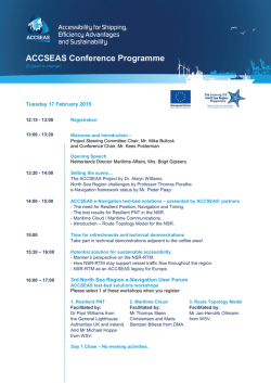

© Copyright 2026