
formation of gullies on mars by water at high obliquity
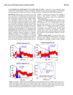
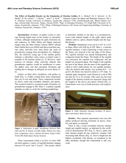
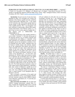
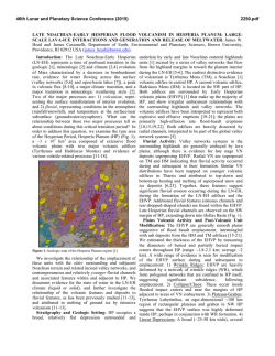
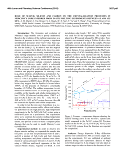
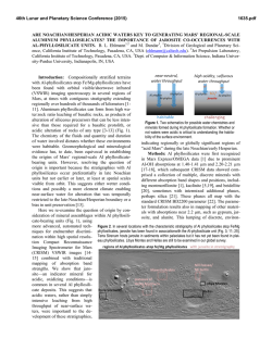
46th Lunar and Planetary Science Conference (2015)
1035.pdf
FORMATION OF GULLIES ON MARS BY WATER AT HIGH OBLIQUITY: QUANTITATIVE
INTEGRATION OF GLOBAL CLIMATE MODELS AND GULLY DISTRIBUTION. J. L. Dickson1, L.
Kerber2, C. I. Fassett3, J. W. Head1, F. Forget4 and J-B. Madeleine4, 1Dep. Earth, Env. & Planet. Sci., Brown U.,
Providence, RI, 02906, USA, [email protected]; 2Jet Propulsion Laboratory, Pasadena, CA, 91109; 3Mt. Holyoke College, South Hadley, MA, 01075; 4Laboratoire de Meteorologie Dynamique, UPMC, Paris, France.
Introduction: The latitude-dependent distribution
[1-4] and non-uniform orientation [5-9] of gullies on
Mars indicate that their formation is controlled by climate conditions at the surface within the last million
years [10-11], while their global distribution [2,4] and
morphology [12-13] show direct correlations with the
ice-rich Latitude Dependent Mantle (LDM), a potential
source for melting. Contemporary activity in gullies
occurs at times that are consistent with the removal of
CO2 frost, leading to destabilization of loose material
on steep slopes [14-17]. While this activity is capable
of mobilizing fines within existing gully channels, the
potential for this process to form new gully systems is
unclear. In particular, this activity may not explain (1)
gullies that exhibit sinuosity values in excess of what
what is measured for dry channels on Earth [18], (2)
gullies with alcove slopes below 25° [8], and (3) channels that incise through tens of meters of permafrost
[19]. These properties suggest that many gullies may
be initiated by flows that are comprised by some percentage of fluid, the most reasonable candidate for
testing being liquid water [12,20-22].
Global Climate Model (GCM) simulations show
that regions where liquid water could exist today are
poorly correlated with gully locations [23], with the
majority of gullies occuring at elevations with surface
pressure below the triple point of H2O [8]. Melting of
ice within 50 cm of the surface in the mid-latitudes is
predicted at ~35° obliquity [20, 22], a scenario that has
occurred within the last million years [24]. Ice is predicted to accumulate in the mid-latitudes at 35° obliquity [25], providing a replenishable source [4, 13].
Further, recently discovered massive CO2 units presently sequestered in the South Polar Layered Deposits
(SPLD) would be mostly sublimated at 35° obliquity,
yielding average surface pressures > 10 mb [26].
This new information prompted us to quantitatively
reassess the potential for liquid water at the surface at
gully locations formed within the last million years.
Methods: Simulations using the Laboratoire de
Météorologie Dynamique (LMD) GCM [27] were run
for three separate starting conditions thought to have
occurred within the last million years [23].
(1) Present day (25° obliquity, 6 mb atmosphere);
(2) ~380 kyr transitional scenario (30°, 8 mb);
(3) ~625 kyr high-obliquity (35°, 10 mb).
Age/obliquity values are from [24] and globally
average pressure values are from [26], which calculat-
ed pressure using the NASA Ames GCM [23]. The
model ran for 4 Mars years before values were obtained for one Mars year, with 8 timesteps recorded per
sol (total of 5352 timesteps). GCM outputs (3.75° (lat)
x 5.625° (lon) cell size) were imported into a Geographic Information System (GIS) that contained a
new detailed map of gullies in the southern hemisphere
based upon Context Camera (CTX) data [28] (Fig. 1a).
GCM cells were filtered to include only those that
overlap with gully locations (Fig. 1b-d). Analysis of
model outputs followed the principles of Haberle et
al., 2001 [23] with regard to quantifying GCM
timesteps when a given cell achieved conditons above
both 273 K and 6.1 mb. Boiling of water was not considered in this analysis, as the focus was on how many
instances predicted the onset of melting, not the duration that meltwater remained on the surface. Timesteps
at which transient melting was possible were counted
(Figure 1). This yielded the first direct quantitative
assessment of liquid water potential at mapped gully
locations.
Results: At present (25° obliquity), conditions for
melting in the southern hemisphere are constrained
primarily by elevation and secondarily by latitude (Fig.
1b). In the southern hemisphere, only the margins and
floors of Hellas and Argyre surpass the triple point of
H2O, consistent with the predictions of Haberle et al.,
2001 [23]. Melting conditions are found in the northern
hemisphere, though surface pressures are lowest during
northern summer, when peak daytime temperatures are
at their highest.
During transitional periods (30° obliquity), melting
conditions are still constrained by elevation; highlatitude (~70°S) lows experience periods above the
triple point; low-latitude highs (e.g. southern
Thaumasia) do not (Fig. 1c). Newton crater (43°S, 160°E), a regional low characterized by thick ice deposits and densely concentrated and well-incised gullies [13, 29], frequently surpasses the triple point in
this scenario.
At high obliquity (35°), conditions above the triple
point are achieved at all locations where gullies are
mapped in the southern hemisphere (Fig. 1d). Unlike
the first two scenarios, conditions for transient melting
are latitude-dependent and exhibit no dependence on
elevation. Even gullies that are mapped at polar latitudes experience > 50 timesteps of surface temperatures > 273 K. Previous calculations using the same
46th Lunar and Planetary Science Conference (2015)
GCM showed that steep pole-facing slopes in the midlatitudes, where gullies preferentially occur [5-9], receive greater insolation at 35° obliquity than surrounding surfaces [20], suggesting that temperature calculations reported here may be minimum estimates.
Discussion: The model results presented here are
consistent with the independent model of Haberle et
al., 2001 [23] for present day conditions: meltwater
production on the surface of Mars today is unlikely,
even if there was a source of volatiles to melt, in all
locations, except the major impact basins in the southern hemisphere. This is also consistent with gully activity observed today being related to CO2 frost [1417]. However, our results suggest that melting of water
ice was considerably more viable as an erosive agent
during recent high-obliquity excursions, coincident
with periods when ice accumulation is predicted to
have occurred at gully locations [4, 25].
GCM results argue for a scenario of gully evolution
that is reflected by their detailed morphology [30]:
formation by liquid H2O at high-obliquity followed my
modification and erosion by CO2-related processes at
low obliquity. This process is predicted to be cyclical,
consistent with morphologic evidence for episodic
gully activity [30-31].
References: [1] Malin and Edgett, 2000, Science,
288, 2330. [2] Milliken et al., 2003, JGR, 108,
10.1029/2002JE002005. [3] Harrison et al., 2014, 8th
Mars, 1030. [4] Head et al., 2003, Nature, 426, 797.
[5] Heldmann and Mellon, 2004, Icarus, 168, 285. [6]
Balme et al., JGR, 111, E05001. [7] Bridges and
Lackner, 2006, JGR, 111, E09014. [8] Dickson et al.,
2007, Icarus, 188, 315. [9] Kneissl et al., 2010, EPSL,
294, 357. [10] Reiss et al., 2004, JGR,
10.1029/2004JE002251. [11] Schon et al., 2009, Geology, 37, 207. [12] Christensen, 2003, Nature, 422, 45
[13] Head et al., 2008, PNAS, 105, 13258. [14] Dundas
et al., 2010, GRL, 10.1029/2009GL041351. [15]
Diniega et al., 2010, Geology, 38, 1047. [16] Dundas et
al., 2014, Icarus, 10.1016/j.icarus.2014.05.013. [17]
Raack
et
al.,
2014,
Icarus,
10.1016/
j.icarus.2014.03.040. [18] Mangold et al., 2010, JGR,
10.1029/2009JE003540. [19] Hobbs et al., Geomorphology, 226, 261. [20] Costard F. et al., Science, 295,
110. [21] Hecht, M., 2002, Icarus, 156, 373.. [22] Williams et al., 2009, Icarus, 196, 565. [23] Haberle et al.,
2001, JGR, 106, 23317. [24] Laskar et al., 2004, Icarus, 170, 343. [25] Madeleine et al., 2014, GRL, 41,
4873. [26] Phillips et al., 2011, Science, 332, 838. [27]
Forget et al., 1999, JGR, 104, 24155. [28] Malin et al.,
2007, JGR, 112, 10.1029/2006JE002808. [29] Berman
et al., 2005, Icarus, 178, 465. [30] Dickson and Head,
2009, Icarus, 204, 63. [31] Dickson et al., 2014, LPSC,
45, 1680.
1035.pdf
Figure 1. Distribution of gullies in the southern hemisphere
and results of three different GCM scenarios. (A) Gullies in
the southern hemisphere of Mars as mapped with CTX data
through mission phase D06. (B) Conditions for melting
under current conditions can only be achieved briefly along
the rims and floors of Hellas & Argyre. (C) Melting is still
elevation-constrained, with more regional lows (e.g. Newton
crater) allowing for summer melting. (D) At high obliquity,
melting can be transiently achieved at all locations where
gullies have been mapped.
© Copyright 2026