
Open-Basin Lakes and the Climate and Surface Environment of
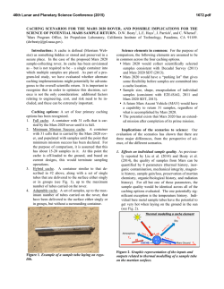
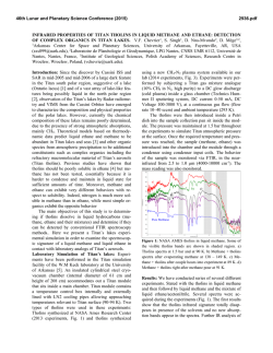
46th Lunar and Planetary Science Conference (2015)
1880.pdf
OPEN-BASIN LAKES AND THE CLIMATE AND SURFACE ENVIRONMENT OF EARLY MARS.
C. I. Fassett1, T. A. Goudge2, J. W. Head2, and J. F. Mustard2, 1Dept. of Astronomy, Mount Holyoke College, South
Hadley, MA ([email protected]), 2Dept. of Earth, Environmental and Planetary Sciences, Brown University,
Providence, RI.
Introduction: The existence of probable lakes on
Mars has been recognized for more than two decades
[1-4]. Lakes can either be open-basins with both inlet
valley(s) and an outlet valley [e.g., 5], or they can be
closed-basins that lack an outlet [e.g., 6]. Although
both open- and closed-basin lakes were likely present
on early Mars, open-basin lakes are easier to study, and
we can have higher confidence that they once held
ponded water. Outlet valleys are recognizable in remotely sensed topography and images because they
cross drainage divides and are often significantly incised. When an outlet is observed, we can be very confident that a lake must have existed, because overtopping of the drainage divide is what allowed the outlet
valley to form in the first place. We can also easily
measure the minimum lake volume and surface area.
In this abstract, we discuss and synthesize observations of open-basin lakes formed by valley networks,
and consider their implications for the early Mars climate and surface environment.
Lake Population: In 2008, a global catalog of
probable open-basin lakes was created [5]; this was
later re-examined by [7]. We required that candidate
lakes meet two requirements: (1) they must be local
topographic lows, outlined by a closed contour within
which water would pond, and (2) they must be fed by
input valley network(s).
This first requirement is met in abundance on Mars
largely because of the numerous impact craters on the
surface; not every candidate open-basin lake is in an
impact crater, but the majority are. The second criterion limits us to lakes formed as a result of, and contemporaneous with, valley networks. This excludes impoundments related to outflow channels.
Our current catalog (Fig. 1) of candidate openbasin lakes has 229 such features, >90% of which we
classify as “confident” identifications [7]. Lakes range
in scale over at least five orders of magnitude in area
(~2 to 500,000 km2) and seven orders of magnitude in
volume (~0.02 to 200,000 km3). The largest of these
lakes are comparable in size to small seas on Earth.
Observational Constraints and Climate Implications: Resurfacing, preservation, and interior deposits:
As a population, the candidate open-basins appear to
have experienced significant resurfacing after the period of lacustrine activity due to volcanism, glaciation,
impacts, and aeolian activity [7]. Post-lacustrine volcanism appears to be particularly important, with at
least 40% of open-basins showing signs of volcanic
resurfacing [7,8].
Approximately one-third of the catalogued basins
have potential lake-related sediments in their interior,
and only ~10% of the open-basin lakes have probable
deltas [7]. It remains uncertain whether the limited
population of deltas is primary and related to sedimentologic/hydrologic factors during the period of fluviolacustrine activity [9,10], or results from poor preservation due to post-lacustrine resurfacing and modification.
Even where potential sedimentary facies are observed in open-basins, in situ aqueous alteration and
evaporite mineral formation appears to have been unimportant [7,11]. This lack of evidence for in situ alteration and mineral precipitation may be an indication
that lacustrine activity was short-lived (and/or ended
abruptly), or it may be the result of unsuitable water
chemistry for mineral precipitation or alteration in these systems.
Lake Chains: Many of the open-basin lakes we
map are part of integrated lake-chain systems where
the outlets of other open-basins are input valleys to
basins that are candidate lakes downstream [5]. Indeed,
the longest possible pathways for surface water on
Mars are thousands of kilometers long and connected
through open-basins. This is quite unlike typical terrestrial drainage networks and is symptomatic of the general immaturity of drainage basin development on
Mars. However, the absence of plate tectonics and associated orogenesis is potentially an important factor
that makes it more difficult to develop mature drainages on Mars than Earth.
The Largest Open-Basin Lakes: The largest openbasin lakes have volumes of 3×10⁴ km3 (Antoniadi,
Tikhonravov, and Cassini craters) to 2×10⁵ km3
(Eridania, [12]), and watershed areas of ~105 km2 to
2×10⁶ km2. The resulting lake volume/watershed area
ratios for these systems are ~50-300 m (see [5], Table
2). If surface hydrology was solely responsible for
filling these lakes, the lake volume/watershed ratios
can be thought of as an equivalent runoff depth required to fill these lakes (assuming perfectly efficient
runoff and no evaporative or infiltration losses).
Alternatively, groundwater (sourced by infiltration
outside the local watershed) may have been an important source to these largest lakes [5]. If so, the integration of surface and subsurface hydrology is a strong
46th Lunar and Planetary Science Conference (2015)
argument for surface conditions above the freezing
point of water on an annual-average basis for at least
some period of time on early Mars. Recharging
groundwater requires that water be able to infiltrate
through the crust, which cannot occur with a globally
intact cryosphere. Observations of open-basin lakes are
not the only reason to suspect that groundwater
transport and surface-subsurface coupling were potentially important on early Mars [e.g., 13-15], but they
are consistent with this hypothesis.
Climate models [16] that continue to suggest that
early Mars was continuously cold are inconsistent with
a globally integrated groundwater system. If these climate models correctly reflect conditions on early Mars,
the open-basin lakes would have to have been filled
from surface runoff in periods of punctuated warming
due to impacts [17] or volcanism [18]. Such punctuated scenarios may have challenges explaining why certain large basins (with relatively small watersheds) end
up as overflowing lakes, while other comparable-scale
basins remained unbreached.
Deluges and Short Climate Excursions (decades to
centuries): Hydrological modeling [19] suggest that
the observed open-basins are inconsistent with formation of valley networks and associated lakes in a
sustained deluge or single short-term climate excursion
of tens-to-hundreds of years, such as might be expected following an impact event. Sustained deluges
would tend to rapidly integrate the landscape and form
more open-basins and outlets than are actually observed [19]. Estimates for the amount of water produced in individual impact events [17] also mobilize
too little water to fill the largest lakes.
1880.pdf
Whether the climate was warm (so runoff was produced by rain) or cold (so runoff was produced by
melting glaciers [20]), observations of both individual
open-basins [21] and larger watersheds [19] are easiest
to reconcile with at least 105 to 106 years of episodic
activity. However, major uncertainties remain. Continued analysis of open basin lakes and their watersheds will help to resolve these questions, leading to a
better understanding of Late Noachian climate history.
References: [1] Goldspiel, J.M. and Squyres, S.W.
(1991) Icarus, 89, 392–410. [2] Cabrol, N.A. and Grin,
E.A. (2010) Lakes on Mars, Elsevier. [3] Cabrol, N.A.
ad Grin, E.A. (1999) Icarus, 142, 160–172. [4] Cabrol,
N.A. and Grin, E.A. (2001) Icarus, 149, 291–328. [5]
Fassett, C.I. and Head, J.W. (2008) Icarus, 198, 37–56.
[6] Goudge, T.A. et al. (2015) this meeting. [7] Goudge,
T.A. et al. (2012) Icarus, 219, 211–229. [8] Goudge,
T.A. et al. (2012) JGR, 117, E00J21. [9] Irwin, R.P. et
al. (2008) 10.1002/9780470760383.ch19. [10] Hoke,
M.R.T. et al. (2014) Icarus, 228, 1-12. [11] Osterloo,
M.M. et al. (2010) JGR, 115, E10012. [12] Irwin, R.P.
et al. (2004) JGR, 109, E12009. [13] Andrews-Hanna,
J.C. et al. (2007) Nature, 446, 163-166. [14] AndrewsHanna, J.C. et al. (2010) JGR, 115, E06002. [15] Wray,
J.J. et al. (2011) JGR, 116, E01001. [16] Wordsworth,
R. (2013) Icarus, 222, 1-19. [17] Segura, T.L. et al.
(2008) JGR, 113, E11007. [18] Halevy, I., and Head,
J.W. (2014) Nature Geos., 7, 865-868. [19] Barnhart,
C.J. et al. (2009) JGR, 114, E01003. [20] Fastook, J.L.,
and Head, J.W. (2014) PSS, in press. [21] Buhler, P.B.
et al. (2014) Icarus, 241, 130-147. [22] Hynek, B.M. et
al. (2010) JGR, 115, E09008.
Fig. 1. Location of catalogued open basin lakes (circles) superposed on MOLA topography with valley
networks from [22].


© Copyright 2026