
GEOLOGIC MAPPING OF CENTRAL VALLES MARINERIS, MARS
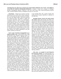
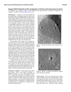
46th Lunar and Planetary Science Conference (2015)
2319.pdf
GEOLOGIC MAPPING OF CENTRAL VALLES MARINERIS, MARS. C. M. Fortezzo1, P. S. Kumar2, and
T. Platz3,4, 1U.S. Geologic Survey, Astrogeology Science Center, 2255 N. Gemini Dr., Flagstaff, Arizona 86001
([email protected]); 2National Geophysical Research Institute, Hyderabad, India; 3Planetary and Remote Sensing,
Freie Universtӓt Berlin, Berlin, Germany; 4Planetary Science Institute, Tucson, AZ.
Introduction: Valles Marineris (VM) constitutes
the largest canyon system in the Solar System and
has a complex history. It consists of interconnected
and enclosed troughs that extend from the Tharsis
volcanic complex to the southern circum-Chryse
outflow channels [1]. The central portion of VM
(CVM, Fig. 1) includes the deepest of these troughs.
Within the CVM troughs occur the thickest exposed sections of (a) layered wall rocks on Mars,
mostly lavas and other early crustal rocks [2-3], and
(b) light-toned interior layered deposits (ILD), generally thought to be of sedimentary or volcanic origin
[4]. The trough floors are extensively covered by
landslides, fans, and eolian deposits. In addition, they
appear locally dissected by channel networks and
include patches of fractured terrain development.
The plateau surfaces that surround these troughs
are extensively cratered and modified by contractional (wrinkle) ridges and extensional faults and grabens, some of which are aligned with pit chains. The
plateau surfaces are also covered by various types of
flow deposits including some of possible volcanic
and sedimentary origin. Other plateau surface deposits include patches of light-toned layered deposits
(LTLD) and eolian mantles.
Despite numerous studies over the four decades
since VM’s discovery by the Mariner 9 spacecraft
[e.g., 1, 4-6], VM stratigraphy and spatial and temporal evolution remain largely based on lower resolution Viking Orbiter image data and interpolated
MOLA topography. Newer image, topographic, and
spectral data justify revisiting previous work including (1) mapping of stratigraphic, tectonic, volcanic,
mass-wasting, and other geologic landforms and
features that document trough development; (2) documentation and interpretation of ILD stratigraphic
and compositional variability and timing of formation; and (3) potential far-field influences (e.g.,
climate and regional tectonics) on CVM development. Given the high resolution (0.25-100 m/pixel) of
the newer data, we limit our study to the CVM region
(Fig. 1), where the largest troughs and majority of the
ILD occur.
Methodology: Using geographic information system (GIS) software, we are characterizing and mapping the distribution of materials and features exposed within the canyons and on the plateaus surrounding CVM at 1:1,000,000-scale, with drafting at
1:250,000-scale using a linear vertex spacing of 500
m. We are examining the timing relationships among
unit outcrops and features through mapping relations
(i.e., unit contacts, marker beds, and unconformities)
and crater densities. For the latter, we are using CraterTools [7], a GIS add-on, to count craters on discrete geologic materials, and CraterStats [8] to plot
and determine ages [e.g., 9]. Tectonic analyses include (1) characterization of various deformational
features (e.g, wrinkle ridges, fractures, faults (dip-slip
and strike-slip), grabens and folds), (2) their spatial
distribution, and (3) relative age.
Figure 1: MOLA shaded relief (463 m/pix, red-orange
= high, purple = lows) overlying THEMIS daytime infrared
mosaic (100 m/pix) of the mapping region (0° to 15°S, 80° to -65°E) with nomenclature, 890km across at equator.
Data sets: The basemap for this project is the
controlled Mars Odyssey Thermal Emission Imaging
System (THEMIS) daytime infrared mosaic [10],
which provides details at 100 m/pix and aids in determining material variation based on thermal differences. The Mars Reconnaissance Orbiter (MRO)
Context Camera (CTX) mosaic provides ~95% coverage over the map area, with 99% coverage within
the troughs, at 6 m/pix. This mosaic provides fine
details of unit relationships and bulk layering. The
CTX mosaic will allow tracing of layered packages
throughout the wall rock and within the ILD. The
Mars Express High-Resolution Stereo Camera
(HRSC) provides both visible-range at 12.5 - 25
m/pix and topography at 50 m/pix. The topography is
unprecedented for CVM and provides topographically derived products (e.g., hillshade and slope), and
46th Lunar and Planetary Science Conference (2015)
allows detailed 3D views. OMEGA and CRISM
hyperspectral data will be used to look at the composition of discrete units and examine variance within
outcrops at key locations. In addition, we also utilize
Mars Global Surveyor MOLA for topographic context outside the map area (460 m/pix), and MRO
HiRISE images (≥25 cm/pix), where supportive.
Eastern CVM mapping results: We have thus
far identified eight categories of material units, based
on their typical geographical settings, geomorphic
expressions, and geologic origins. Categories are
made up of multiple map units, subdivided by additional morphology criteria, and by relative age. In
addition, we are documenting further temporal relationships within units, including terraces within wall
rocks and individual landslide lobes within overlapping sequences. Temporal inferences can be made
based on (a) cross-cutting relationships among outcrops of the same unit separated by internal contacts
and structures and on (b) dating of temporally related
features such as landslide alcove development.
The unit groups consist of: (1) Surficial materials
including low-albedo mantles, sand sheets, transverse
aeolian ridge fields, and dunes; (2) crater and ejecta
materials; (3) mass wasting typically proximal to
canyon walls with lineated, blocky, stratified blocks,
and long runout landslides; (4) catena materials,
including a floor and a wall unit, including incipient
collapse features; (5) chasma floor materials consisting of ridged, smooth, rugged materials, terraceforming blocks, and cavi exposures of subsurface
materials; (6) interior layered deposits within VM
troughs that include cap rock, and massive or poorly
lineated underlying units, to be further subdivided
where possible; (7) wall deposits consisting of a
gullied, smooth, and coarser-grained unit; and (8)
plateau materials made up of three widespread plateau units, three fluvial terrace units, flow materials,
and a highland massif unit.
Detailed crater counts are currently limited to
CVM plateau units. We are also working on the VM
main opening phase which separated Lunae, Ophir,
and Thaumasia Plana. The cursory results show
Thaumasia and Lunae to have similar primary emplacement ages (~3.75-3.6Ga) with Ophir indicating
a wider range of emplacement (~4.0-3.4Ga). The
older age in Ophir Planum is associated with an interpreted ancient volcanic edifice and the younger
age is associated with the faulted plateau units. Two
resurfacing periods are indicated by the crater statistics. The first is 2.7Ga, 2.8–2.2Ga, and 1.9Ga and the
second is geologically recent at 1.0Ga, 0.6-0.2Ga,
and 1.3-1.0Ga in Thaumasia, Ophir, and Lunae Plana, respectively.
2319.pdf
In addition, we are mapping linear features where
useful in reconstructing the geologic history. These
features include unit contacts with certain, approximate, buried, and internal younger/older relationship
types. Tectonic features include inferred grabens,
normal faults, and contractional wrinkle ridges. Some
ridges are differentiated as sinuous (possible inverted
fluvial features), curvilinear on landslides, and erosional geomorphologies (yardangs and massifs).
Scarps are mapped at collapse margins, landslide
heads and toes, and flow margins.
The tectonic feature mapping shows 5 generations
of graben development preserved on the plateau and
within the canyon walls: (1) oriented roughly NNESSW, mostly confined to Sinai Dorsa, surrounding an
ancient caldera; (2) circumferential to the alcoves in
southern Melas Chasma, possibly key to expansion of
these alcoves; (3) oriented roughly NNE- SSW, paralleling most of the wrinkle ridges, located in
Thaumasia and Lunae Plana, and in the Tithoniae
Catenae region; (4) oriented WNW-ESE and paralleling and bounding the chasmata throughout the region, these graben are prevalent on Ophir Planum,
may be responsible for canyon widening; (5) isolated
to Ophir Planum, these are curvilinear faults expressions that may be reactivations of older structures.
Channels and rilles are also differentiated to show
the influence of volcanic and fluvial processes in the
development of CVM. Finally, we mapped crater rim
crests and buried crater features larger than 5 km.
Future work: We continue to map the western
half of CVM. We will develop a description and
correlation of map units, continue crater statistics on
the plateau units, begin collecting bedding orientations within and further subdivide the interior layered
deposits, begin testing formational hypotheses using
the mapped structures, and further characterize the
landslide morphologies into a robust classification
scheme and spatial distributions.
Acknowledgements: This work is supported by
NASA through a Planetary Geology & Geophysics
program via grant #NNH13AW23I.
References: [1] Lucchitta B.K. et al. (1992) in
Kieffer H.H. et al. (eds.) Mars, U. Arizona Press, p.
453-492. [2] McEwen A.S. et al., (1999) Nature, 397.
[3] Murchie S.L. et al. (2010) J. Geophys. Res., 114.
[4] Lucchitta B.K. et al. (1994) J. Geophys. Res., 99.
[5] Witbeck N.E. et al. (1991) USGS Map I-2010. [6]
Dohm J.M. et al. (2009) J. Volcan. Geotherm. Res.,
185. [7] Kneissl T. et al. (2010), Planet. Space Sci.,
59 (11-12). [8] Michael G.G. and Neukum G. (2010)
Earth Planet. Sci. Lett., 294. [9] Platz T., et al.
(2013), Icarus, 225. [10] Fergason R.L. et al. (2013)
Lunar Planet Sci Conf, Abst. #1642.
© Copyright 2026