
Cryptomare, Lava Lakes, and Pyroclastic Deposits in the Gassendi
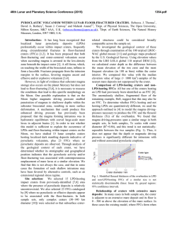
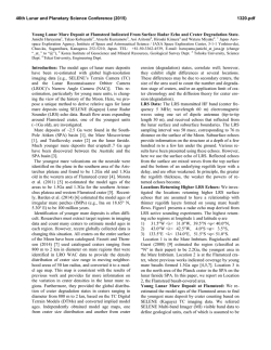
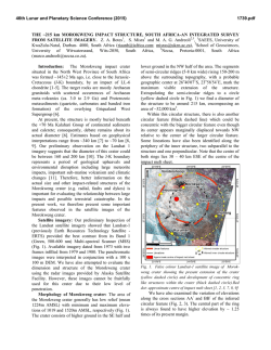
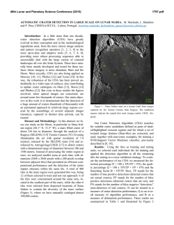
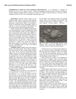
46th Lunar and Planetary Science Conference (2015)
1310.pdf
CRYPTOMARE, LAVA LAKES, AND PYROCLASTIC DEPOSITS IN THE GASSENDI REGION OF
THE MOON: FINAL RESULTS. B.R. Hawke1, T.A. Giguere1,2, C.A. Peterson1, S.J. Lawrence3, J.D. Stopar3, and
L.R. Gaddis4. 1Hawaii Institute of Geophysics and Planetology, University of Hawaii, Honolulu, HI 96822,
2
Intergraph Corporation, P.O. Box 75330, Kapolei, HI 96707, 3School of Earth and Space Exploration, Arizona
State University, Tempe, AZ 85281, 4U.S. Geological Survey, Astrogeology Science Center, Flagstaff, AZ 86001.
Introduction: Gassendi is a floor-fractured impact
crater (diameter = 110 km) located just north of Mare
Humorum on the western nearside of the Moon. The
Gassendi region contains a number of unusual features
which have long provoked controversy. These include
smooth plains and possible volcanic constructs on the
floor of Gassendi [1,2], a large radar anomaly west of
the crater [3], possible pyroclastic deposits in Mersenius crater, and a cryptomare deposit [3]. We have analyzed Lunar Reconnaissance Orbiter Camera (LROC)
Wide Angle Camera (WAC) and Narrow Angle Camera (NAC) images, as well as a variety of other spacecraft data, to investigate the composition and origin of
geologic units in the Gassendi region. The goals of
this study include the following: 1) To determine the
origin of possible volcanic features on the floor of Gassendi, 2) To search for cryptomare deposits and to investigate the processes responsible for their formation,
3) To determine the compositions and ages of any buried mare units, and 4) To investigate the distribution
and compositions of pyroclastic deposits.
Methods: Both LROC WAC and NAC images
were utilized in this investigation. The high resolution
(0.5 m/pixel) provided by the NAC images was critical
for the study of the smallest volcanic features. Topographic data were provided by the LROC GLD100 [7].
The U.S.G.S. Astrogeology Program has published on
CD-ROM a Clementine five-color UV-VIS digital image model (DIM) for the Moon [e.g., 4]. Images from
this DIM were used to produce an image cube centered
on the Gassendi area. This calibrated image cube
served as the basis for the production of a number of
other data products, including optical maturity
(OMAT) images and FeO and TiO2 maps [5,6]. Fivepoint spectra were extracted from the calibrated and
registered Clementine UV-VIS image cube.
Results and Discussion:
Pyroclastic Deposits. A previously unmapped dark
mantle deposit of probable pyroclastic origin was identified in the highlands northeast of Gassendi. Dark
material mantles and subdues underlying highland terrain. In places, it is draped over rugged mountain
ridges. The deposit covers ~250 km2 and is centered at
14.8°S, 37.7°W. A probable source vent has been
identified using LROC images (Figure 1). This endogenic crater is associated with a linear rille and has an
average diameter of 2.5 km and an average depth of 88
m. Two five-point spectra extracted for the dark mate-
rial indicate that the deposit is dominated by mare basalt fragments and contains minor amounts of highland
debris. In addition, the dark materials exhibit enhanced FeO and TiO2 values.
Several localized pyroclastic deposits have been
identified along fractures on the floor of Mersenius
crater [3,13,14]. Five-point spectra collected for two
pyroclastic deposits on the northwestern portion of the
crater floor indicate a basaltic composition.
Figure 1. Portion of a mosaic of NAC frames
M193203275L&R. The pyroclastic vent is indicated
by the white arrow. North is up.
Gassendi Crater Interior. While mare basalt deposits have been identified in the southern, southeastern, and southwestern portions of the Gassendi interior
[e.g., 1,2,8,9,10,11,12], no mare units have been
mapped in the west central and northwestern portions
of the crater floor. However, Schultz [1] described
several features of possible endogenic origin in the NW
portion of the floor. These included an irregular depression partly surrounded by a scarp which may be a
lava terrace. Large parts of the west central and NW
floor exhibit FeO values (12-14 wt.%) that are higher
than those of the surrounding floor material (8-12
wt.%). A number of small impact craters excavated
even more FeO-rich material. These craters range from
1 to 1.4 km in diameter, and LROC images show that
46th Lunar and Planetary Science Conference (2015)
they have very faint dark haloes. The maximum FeO
abundances measured for the dark haloes range from
14.4 to 14.8 wt.%. These values fall within the range
of FeO abundances (14-18 wt.%) determined for the
mapped mare units in the southern, SE, and SW portions of the crater floor. Five-point spectra were extracted from the Clementine UV-VIS image cube for
two of the dark-haloed impact craters (DHCs). These
spectra have moderately strong “1µm” bands centered
near 0.95 µm. The materials for which these spectra
were obtained have mafic assemblages dominated by
high-Ca clinopyroxene. Both the chemical and spectral
data indicate that mare basalts were exposed by DHCs
on the western portions of the Gassendi crater floor.
Mare basalt flows were emplaced in parts of the western floor and, later, were obscured by highlands-rich
ejecta from Gassendi A and other craters, and a cryptomare deposit was formed.
Schultz [1,2] also described features of possible
volcanic origin in the northeastern floor of Gassendi.
These included high-level lava marks within fractures,
and perched plains units. LROC NAC images show a
terraced depression which may represent a drained lava
lake (Figure 2). The region with these possible volcanic features exhibits enhanced FeO and TiO2 values.
The FeO abundances range from 12 to 16 wt.%. The
highest FeO concentrations (14-16 wt.%) are associated with perched plains deposits NE and SW of Rima
Gassendi II. These perched plains have a relatively
low albedo and enhanced TiO2 abundances (2-3 wt.%).
This area corresponds to the ST spectral unit defined
by Chevrel and Pinet [8,9] on the basis of Earth-based
telescopic multispectral images. They determined that
clinopyroxene was a major component in the ST material.
We collected five-point spectra from the Clementine image cube for four fresh surfaces associated with
fracture walls and lava terrace scarps in the FeO-rich
portion of the NE floor. These spectra exhibit strong
“1µm” bands centered at or longward of 0.95µm. The
lithologies for which these spectra were collected clearly contain large amounts of pyroxene and have mafic
assemblages dominated by high-Ca clinopyroxene.
These fracture walls and terrace scarps are dominated
by mare basalt fragments. The results of previous studies [1,2,10,11] as well as the chemical and spectral data
presented in this study indicate that mare volcanism
occurred in the NE portion of the floor of Gassendi
crater. These mare surfaces were contaminated and
obscured by non-mare debris from Gassendi A and
other craters in the surrounding highlands, and cryptomare deposits were formed.
1310.pdf
Figure 2. Portion of a mosaic of NAC frames
M193210370L&R. Arrows indicate a lava terrace.
North is up.
Lava Lakes in Gassendi. As discussed in the previous section, evidence exists for drained lava lakes on
the floor of Gassendi. LROC images show that welldeveloped lava terraces occur on all sides of the northeastern drained lake (Figure 2). Topographic data
show that the elevation of the terrace top changes as a
function of position around the depression with elevations increasing to the south. Apparently, structural
adjustments in the crater floor resulted in uplift of the
southern portion of the drained lake. The maximum
depth of the lava lake was at least 200 m. The NW
drained lake exhibits a lava terrace along its southern
edge. The elevation of the terrace top is constant along
its exposed length. The maximum depth of this lake
was ~90 m. A third lake existed on the SW portion of
the crater floor. A lava terrace was identified at one
location in this area.
References: [1] Schultz P. (1976) Moon Morphology, 626. [2] Schultz P. (1976) Moon, 15, 241. [3]
Hawke B. et al. (1993) GRL, 20, 419. [4] Eliason E. et
al. (1999) LPS XXX, #1933. [5] Lucey P. et al. (2000)
JGR, 105 (E8), 20,297. [6] Lucey P. et al. (2000)
JGR, 105 (E8), 20,377. [7] Scholten F. et al. (2012)
JGR, 117, 12 pp. [8] Chevrel S. and Pinet P. (1990)
PLPSC 20, 187. [9] Chevrel S. and Pinet P. (1992)
PLPSC 22, 249. [10] Hiesinger H. et al. (2000) JGR,
105 (E12), 29,239. [11] Hackwill T. et al. (2006)
MAPS, 41, 479. [12] Titley S. (1967) U.S.G.S. Map I495. [13] Gaddis L. et al. (2003) Icarus, 161, 262. [14]
Gustafson O. et al. (2014) LPSC XLV, #2044.
© Copyright 2026