
2296
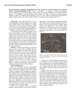
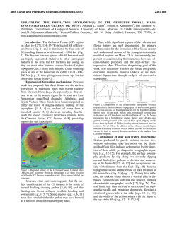
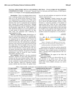
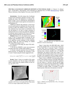
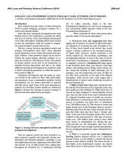
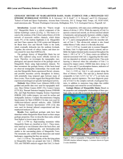
46th Lunar and Planetary Science Conference (2015)
2296.pdf
SEDIMENTOLOGY OF A RIVER SYSTEM WITH A SERIES OF DAM-BREACH PALEOLAKES AT
IDAEUS FOSSAE, MARS. F. Salese1, G. Di Achille2, G. G. Ori1,3; 1International Research School of Planetary
Sciences, Università “G. D’Annunzio”, Pescara, Italy; 2Istituto Nazionale di Astrofisica, Osservatorio Astronomico
di Teramo, Italy; 3Ibn Battuta Centre, Universite Cady Ayyad, Marrakech, Morocco.
Introduction:
Several
possible
martian
paleodrainages and well preserved fluvial and lacustrine deposits have been recognized and studied in the
last fifteen years. This work is based on Digital Elevation Model (DEM) derived from CTX and HiRISE
stereo images, which enabled the identification of an
ancient drainage complex, consisting of i) a nearly
300-km-long valley system located westward of Idaeus
Fossae, in Tempe Terra and ii) a series of dam-breach
paleolakes. The first part of this system has been dated
to the Hesperian-Amazonian by [1]. Here, we present
the hydrological reconstruction of the drainage system
and a sedimentological study of the series of dambreach paleolakes.
Based on geomorphology, sedimentology and terrestrial anologs, the aim of our work is to: a) study the
complex channel flow paths draining into Ideaus Fossae after forming a series of dam-breach paleolakes
and b) investigate the origin and evolution of this valley system and its implications about climate, tectonic
control and potential connection to the putative martian
ocean. As it is know from the Earth, Martian paleolakes and deltas give clues on the hydrological conditions during the planet’s history and may provide valuable information about the origin, magnitude and duration of fluid water on the surface [2,3,4,5,6,7].
Study Area: The study area is approximately located on the eastern margin of Tempe Terra, westward
of Idaeus Fossae in the Acidalia region, between 33°N
and 37°N of latitude and 302°E to 308°E of longitude.
We mapped several paleochannels and basins within
the region (Fig. 1). Due to the presence of a series of
dam-breach paleolakes (five dams in the upper basin
and three and two dams in the main and lower basin,
respectively) and also considering their asynchronous
evolution, we divided the system into four parts: an
upper part (hereafter referred to as Upper basin, UB)
apparently sourced from fluidized ejecta blankets
(FEBs), a central part (hereafter referred to as Main
Basin, MB, which coincides with the crater delta depression), an eastern part (hereafter referred to as Lower Basin, LB), and a terminal part (hereafter referred to
as Terminal Basin, TB) that flowed into Ideaus Fossae
region. The lake chain consists of six open basins (with
associated fan-shaped sedimentary deposits) and covers an area of about 2500 sq. km over a E-W stretch
of about 100 km. The easternmost and northernmost
paleochannels appear to start from fluidized ejecta
blankets (FEBs). All the paleochannels in the UB
Fig. 3
Fig. 2
Figure 1 ) (top) HRSC nadir mosaic draped on CTX-derived
topography of the study area. (bottom) Line drawing and timescale evolution of hydrological activity.
were apparently flowing from W/NNW to E and terminate in MB. The MB consist of a 25-km diameter
impact crater (Fig. 2) characterized by flat floor, and
terraces and the lack of a central peak area. The LB
and TB are characterized by a vast avulsive system and
an anabranching network.
Anastomosing rivers on Mars: The LB and TB
of Idaeus Fossae fluvial system represent a very good
example of well-preserved anastomosing river system
on Mars. In the middle-final part of the TB there is an
Oxbow lake, or meander cutoff (Fig. 3). Only one loop
is cut off and the lake formed has crescent shaped.
The rarity or absence of meander scrolls and oxbow lakes on anastomosing river floodplains, on Earth,
was considered to be a fundamental characteristic of
anastomosing system in some studies [8, 9]. Anastomosing streams in Idaeus Fossae (LB and TB) have
low bank erodibility and medium to high sediment
supply as we especially see in the final part of the TB
alluvial plains, just before reaching the depression,
where the channels are not very deep. This could be
due to the fact that usually anastomosing rivers are not
fixed in position, and they do not aggrade vertically for
long periods, as we can see on the Earth rivers anlogue
46th Lunar and Planetary Science Conference (2015)
Ovens and Kings rivers (Australia) they avulse across
wide floodplains, causing a variable surface of tipically
shallow highs and lows [10] .
Interpretation: The six open basins are topographically connected and were likely partially coeval. All
drain eastward into a main 25-km-diameter crater-lake
forming a complex and multilobate deltaic deposit
whose front lies at about 1800-1820 m below the martian datum (Fig. 2). The deltaic deposit is about 8-kmlong and morphologically resembles the Jezero delta,
showing a well-developed distributary pattern with
evidence of channel switching on the delta plain. The
extension and morphology of the fluvio-lacustrine system suggest relatively long (>103 yrs) formation timescales as also supported by the presence of the main
fan delta in the central open basin. The overall water
source for the 300-km-long fluvial system is unclear,
though the occurrence of many rampart craters and the
relationships between their ejecta and the channels
suggest that subsurface volatiles might have played an
important role.
Summary and Conclusion: The studied martian
paleo-fluvio-lacustrine system shows well preserved
fluvial morphologies suggesting its relatively recent
formation. Moreover it cuts the NFptm unit and the
Amazonian-Hesperian plains according to [1]. Based
on terrestrial analogs, if these flows were produced by
precipitations due to a terrestrial-like climatic cycle,
the deposit would have required thousands of years to
form.
However, as for the Earth, it is unclear whether anamostosis is a state of transition or an equilibrium fluvial form on Mars. Some investigators interpret anastomosis as an expression of instability induced by climatic change, but not much is known, both on Earth
and on Mars, about the response time of river systems
to altered hydrological regimes, due to a poor hydraulic understanding of anastomosis. How long could
have lasted the anastomosis system of Idaeus Fossae?
2296.pdf
Figure 2 ) Close-up of the crater lake, delta and spillover channels from CTX image draped on CTX digital elevation model.
The length of time over which the paleovalley fluvial
system was formed is uncertain. Nevertheless, on Earth
formation of wide alluvial ridges by active channel
meandering needs time. On Earth Knighton and Nanson (1993, p. 622) suppose that Cooper Creek has
maintained as an anastomosing system for over 50,000
years. Therefore, it is likely that the studied system
testifies the occurrence of sustained (in the order of 103
yrs) hydrological activity at Idaeus Fossae during the
Hesperian-Amazonian transition.
References: [1] Neesemann A. et al. (2014) LPS
XLV, 2313. [2] Malin, M. C., & Edgett, K. S. (2003).
Science, 302(5652), 1931-1934. [3] Irwin, R. P. et al.,
(2005). JGR (1991–2012), 110(E12). [4] Di Achille,
G. et al. (2006) GRL, 33(7). [5] Kraal, E. R. et al.
(2008). Nature, 451(7181), 973-976. [6] Hauber, E. et
al. (2009). PSS, 57(8), 944-957. [7] Villiers, G., et al.
(2013). JGR, 118(4), 651-670. [8] Smith, D. G. (1983).
Modern and ancient fluvial systems, 155-168. [9] Nanson, G. C., & Croke, J. C. (1992). Geomorphology,
4(6), 459-486. [10] Schumm, S. A. et al. (1996). GSA
Bulletin, 108(10), 1212-1224.
Figure 3 ) Close up of the oxbow lake and after cut-off straight river course from CTX (L) and HiRISE (R) images draped on CTX DEM.
© Copyright 2026