
A Field of Small Pitted Cones on the Floor of Coprates Chasma, Mars
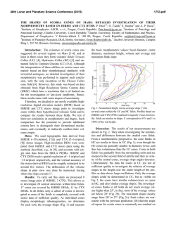
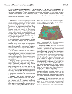
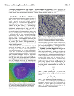
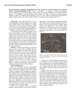
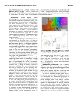
46th Lunar and Planetary Science Conference (2015)
1476.pdf
A FIELD OF SMALL PITTED CONES ON THE FLOOR OF COPRATES CHASMA MARS:
VOLCANISM INSIDE VALLES MARINERIS? E. Hauber1 , P. Brož2,3, A.P. Rossi4, G. Michael5, 1Institute of
Planetary Research, DLR, Berlin, Germany, [email protected], 2Institute of Geophysics ASCR, v.v.i., Prague,
Czech Republic, 3Institute of Petrology and Structural Geology, Charles University, Prague, Czech Republic, 4Jacobs
University, Bremen, Germany, 5Institut für Geologische Wissenschaften, Freie Universität Berlin, Germany.
Summary: We present observations of a field of
>100 pitted cones and mounds situated on the floor of
Coprates Chasma (part of Valles Marineris (VM);
Fig. 1), which display similarities to terrestrial and
martian scoria cones. If these cones are indeed volcanic
in origin, they will significantly expand our knowledge
about the morphometry of pyroclastic cones on Mars.
Moreover, a magmatic origin, which would necessarily
post-date the opening of the main VM troughs, would
contribute to our understanding of the volcano-tectonic
evolution of VM.
Figure 1: Location of investigated cones (triangles) and
mounds (dark circles) in eastern Coprates Chasma (CTX
mosaic). The edifices are spread over the entire trough.
Background and Motivation: It has long been
suggested that volcanism played a role in the formation
of Valles Marineris [e.g., 1], but unambiguous evidence has been rare. Recent images acquired by the
CTX camera (~5-6 m/px) reveal the existence of several fields of small pitted cones, mainly associated with
chaotic terrain in the eastern part of VM [2,3] and also
in Coprates Chasma [3,4]. Coprates Chasma is a linear
graben extending in west-east direction for ~1000 km.
It probably formed as one of the most recent main depressions of the VM system. Based on morphological
similarities, Harrison [3] suggested that these cones
might represent scoria cones, but without providing
further details. Meanwhile the whole area is covered by
CTX images that enable analysis of the entire cone
field. One cluster of pitted cones is covered by a
HiRISE stereo pair, allowing the production of a
HiRISE Digital Elevation Model (DEM). Based on
these new data, we studied the cones in unprecedented
detail. Here we show preliminary results.
Data and Methods: We used images from CTX,
HRSC, and HiRISE. Topographic information is derived from single MOLA shots, HRSC DEMs, and
HiRISE and CTX DEMs that were computed using the
methods described in [5]. HRSC, CTX, and HiRISE
DEMs have a grid spacing of~50-100 m/px, ~10 m/px,
and ~1 m/pixel, respectively.
Observations: The cones and mounds are widely
spread over a total area of about 155 × 35 km. Some
cones stand alone, others are concentrated in clusters
with up to ten edifices (Fig. 2). In plan view, their
morphology is characterized by circular to elongated
shapes. Their flanks have slopes up to 25°, but are generally more shallow. Cone basal diameters vary from
0.5 km up to 2.2 km, with a mean of 1 km (based on 23
cones). Most of them have summit craters (Fig. 2a),
which have diameters from 0.15 km up to 0.8 km
(mean 0.3 km). In some cases craters are superposed
by other craters suggesting the lateral migration of explosion sites or feeder dikes. Typically, the cones are
not breached, but there are two exceptions which seem
to result from explosion and/or collapse of the cone. In
some cases cones are superposed on units with a rough
texture that forms local bulges (Fig. 2b,c). To compare
the cones morphologically with martian and terrestrial
analogues, we measured the basal diameters of the
cones (WCO) and the crater diameters (WCR). The
WCR/WCO ratio ranges between 0.22 and 0.5, with an
average of 0.34. Fresh terrestrial and Martian scoria
cones have ratios of ~0.4 [6], and ~0.27 [7], respectively. The cones appear relatively pristine, and small
impact craters do not change their shapes significantly.
Discussion and Conclusions: The studied cones
bear many morphological similarities to edifices in
Hydraotes Chaos [2] and Ulysses Colles [7] that were
previously interpreted as scoria cones. The Coprates
cones are smaller (WCO on average 1 km) than the Hydraotes cones (1.5 km) and the Ulysses cones (2.3 km),
but with similar WCR/WCO ratios (0.34 for cones in
Coprates and 0.27 for cones in Ulysses). This might be
caused by a higher atmospheric pressure at the floor of
Coprates Chasma (~5 km beneath Mars’ global datum)
disabling a wider dispersion of ejected particles from
the vent [8], by a smaller amount of erupted material or
by smaller erosion. The associated elevated rough units
around the edifices are similar to what is observed in
Hydraotes Chaos and Ulysses Colles. Similar rough
46th Lunar and Planetary Science Conference (2015)
1476.pdf
Figure 2: Three clusters of cones and mounds in Coprates Chasma. Note the rough elevated units on which the edifices are superposed. We interpret them as lava flows and/or pyroclastic deposits. (a) HiRISE ESP 034131 1670, centered 12.73°S, 62.8°W
(b) CTX image G20_026061_1675, 13.28°S, 60.89°W (c) CTX image B22_018268_1659, 12.71°S, 62.38°W.
textures around terrestrial scoria cones are associated
with lava flows and possibly pyroclastic deposits.
At HiRISE resolution, further details provide possible hints to the nature of the cones. Where scarps
break the surface of the otherwise smooth-textured
cones, series of fine parallel layers are visible in some
places (Fig. 3 a and d, b and e). Although other interpretations are possible, this would be consistent with an
volcanic origin of some cones, specifically as phreatomagmatic edifices, e.g., tuff cones. In another location,
the surface texture adjacent to a cone is reminiscent of
that of a lava flow surface (Fig. 3 c and f).
The spatial distribution of cones (2 point-azimuth
analysis; for details see ref [9]) reveals two main trends
of a possible structural control. One is oriented parallel
to the main VM trend (~N110°), while another is
~N75° (Fig. 4). The first trend suggests that magma
feeding the cones may have ascended (as dikes?) along
weakness zones created by VM formation.
Our preliminary results, therefore, support previous
suggestions [4,5] that this field is probable volcanic in
origin and consists primarily of scoria cones. If so, this
field in Coprates Chasma may be among the largest
known fields of scoria cones on Mars. Ongoing inves-
tigations will help to extend our knowledge on scoria
cone formation on Mars and will also help to provide
further insight about the evolution of Valles Marineris.
Figure 4: Results of 2-point azimuth analysis. (top left) Histogram of distances between vents. (bottom left) Map of cone
positions and distribution of connecting lines with a length
smaller than the minimum significant distance. (right) Rose
diagram of trend analysis, black bars show main trends.
References:. [1] Lucchitta, B.K. (1987) Science, 235,
565-567. [2] Meresse, S. et al. (2008) Icarus, 194, 487–500.
[3] Harrison, T.N. (2012) LPSC, XLIII, Abstract #1057.
[4] Harrison, K.P. and Chapman, M.G. (2008) Icarus, 198,
351–364. [5] Moratto, Z.M. et al. (2010) LPSC,
XLI, Abstract #2364. [6] Wood, C.A. (1980) J.
Volcanol. Geotherm. Res., 7, 387–413.
[7] Brož, P. and Hauber, E. (2012) Icarus, 218,
1, 88–99. [8] Brož, P. et al. (2014) Earth Planet. Sci. Lett., 406, 14-23. [9] Brož, P. and Hauber, E. (2013) JGR-Planets, 118, 1656-1675.
Figure 3: Details of cone morphology (HiRISE).
(a) ESP_033986_1670, 12.73°S/297.2°E.
(b) ESP_036109_1675, 12.4°S/297.21°E.
(c) ESP_036254_1665, 13.28°S/298.52°E.
(d) Parallel, flat-lying layers exposed in inner
crater wall. (e) Similar fine layering in scarp of
eroded cone. (f) Exhumed (?) surface with lobate margins adjacent to cone, reminiscent of a
lava flow surface texture.
© Copyright 2026