
Lodz and Suyanggae
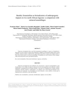
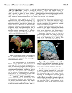
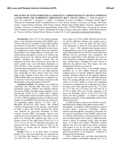
The 19th International Symposium :
Suyanggae and Her Neighbours
제19회 국제회의 수양개와 그 이웃들
Lodz and Suyanggae
2014.6
Organized and Edited by
Lucyna DOMANSKA , Yung-jo LEE and Jong-yoon WOO
About the Lower Paleolithic of Sakhalin,
The Sennaya-1 Site
Alexander A. VASILEVSKI
The Sakhalin State University, Yuzhno-Sakhalinsk, Russia
The Institute of Archaeology & Ethnology,Siberian Branch Russian Academy of
Science ,Novosibirsk, Russia
[email protected]
The site Sennaya-1, one of the Lower Palaeolithic sites of the Far East of Russia
is located on the right bank of the Sennaya river, in the North-Western entrance
of the Susuya valley, in 8 km to the southwest from a settlement of Sovietskoye,
in Dolinsk district Sakhalin island region. The object is situated on the flat site on
the slope of a hill turned to the sea of Okhotsk (47 25 ' 51 ", 142 39 ' 43") (figure
1). The altitude is 50 m(figures 2 and 3). In the year of 1998 the buried Middle
Pleistocene terrace and the artifacts in situ were discovered. In 1999 - 2000, the
excavations had covered 60 sq. m.1)
1) The samples selected by professor Nagatomo Tsuneto and Vasilevski A. in the site were processed
Session IV : Suyanggae and Her Neighbours
147
According to Alla Aleksandrova the age of this terrace is 400-200 ka and it is
situated along the southern coast of the island [Александрова, 1982, p. 149 150]. The Middle Pleistocene alluvial sediments, such as those described lower for
Sennaya-1 site, usually form the frontal parts of this terrace in the riversides. The
hilly plain area where the Sennaya-1 site is situated has stretched for about 25 km
from the north to the south in the foothills of the Dolinsk ridge. The described ridge
lasts along the maritime accumulative plain. The Lebjazhie lagoon lakeshore is
situated in 3, and the Okhotsk seaside is in 6 km to the east from the site.
The coastal plateau cut up by the valleys of the small rivers formed the Middle
Pleistocene landscape here. The depth of those valleys nowadays is about 80 - 100
m, and their average length varies from 5 to 10 - 11 km. In the warm interglacial
climate of the end of the Middle Pleistocene, the site of Sennaya- 1 was situated
in the mouth of the small river of the same name on a shore of the lagoon estuary
of the Naiba River. Within the cold climate of the Wurm maximum the seacoast
receded to tens kilometers off to the east from foothills. In addition, the site
appeared to situate on the hilly plain before the forest-tundra or tundra boggy
landscape area. That time it was washed by the Sennaya river, not Naiba estuary or
lagoon as before. The distinction in a chemical compound of sediments of the top
and the bottom parts of the cultural layer of the site can be explain by this scenario.
We suppose the interglacial phases of the Middle Pleistocene were the best periods
for habitation around the Sennaya site.
in 2002 at the University of Nara (Japan) by professor Nagatomo Tsuneto and Professor Shitaoka
Yoshinao the OSL dates were received four of ten layers. The pollen and the other analyses were
executed by the group of scientists of the Scientific Research Institute of the FESU (Vladivostok)
under direction of Dr. Y.A. Mikishin.; the petrography analysis by V.A. Sorokina.
148
Lodz and Suyanggae
The quaternary layers (figure 4) containing artifacts (figures 5 and 6), lie above
the basic clay layer of the white color. The cross section consists of the 10 layers.
Their capacity increases from the East to the West from 60 to 220 cm. Layer 1.
Modern black color soil (10 - 15 cm).Layer 2.Sandy loam of brown color (10 - 55
cm).Layer 3. Grey sandy loam. A pure dense layer without stones and extraneous
inclusions (20 - 30 cm). When there is a mixture with the layer 4, it increases up to
90 cm. The OSL date of the lower part of the layer 3 (- 40 cm) is154 ±15 ka.Layer 4.
Dense loam of grey color, sated by gravel and round pebbles of sandstone polished
by water (40 - 50 in the east up to 90 - 100 cm, in the western part of the cross
section). Sample 2 (-110 cm) is dated by OSL method as 167 ±19 ka.Layer 5. A
dense brown sandy loam, with pebbles of sandstone, falling from - 100 cm in the
eastern up to -200 - 220 sm in the western part of the cross section (10 – 30 cm).
This layer is understood as a Middle Pleistocene soil changed by the compression.
The sample 3 (layer 5, - 130 cm)is dated by the OSL as 175 ±28 ka.Layer
6.Reddish-brown dense sandy loam with the pebbles and boulders of sandstone
(10 - 40 cm).Layer 7.A well-sorted marsh fine sand. Sample 4 (-160 cm) is dated
by the OSL as 197±32 ka.Layer 8.The thin lenses of dense loam and well sorted
sand including pebbles and boulders of sandstone (20 - 30 cm).Layer9. Fine grey
sand with silt and fine pebbles, understood as the Middle Pleistocene lagoon shore
sediments (5-10 cm).Layer 10. The white-blue clay of a dense viscous structure,
formed because of natural disintegration of the rocky basement by the seawater.
Professor Tsuneto Nagatomo and Professor Yoshinao Shitaoka processed the
OSL dating using the NRL-99-OSTL in the laboratory of university Nara. The OSL
age was counted up under formula OSL age = Gy: (mGy:a), dividing the paleo doze
(Gy) on a year doze (mGy/a.) The sequence between the position of the sample
Session IV : Suyanggae and Her Neighbours
149
[Table 1] The OSL Dating of the Sennaya-1 Site. By Tsuneto NAGATOMO,
Yoshinao SHITAOKA (JAPAN).
in the cross section and its calculated age is shown in the table. The dates become
older from top to bottom within the limits of 229 - 139 ka.
The results of OSL dating reflect the periods of the processes of the sedimentation
on the site.
The results of OSL dating reflect the periods of the processes of the sedimentation
on the site. The discussed data shows, that formation of sediments of the described
terrace and, accordingly, the periods of the human activity in the site, occurred
stage by stage during the time from 197±32 up to 154 ±15 ka. Layers 10-9, 8 - 3
and 2 – 1 were formed during three different periods of the Middle and the Late
Pleistocene. The layers alternation of the site of Sennaya-1 shows the stage-by-
150
Lodz and Suyanggae
stage accumulation of sediments. Layers 10 and 9 have the marine (and\or) lagoon
genesis, layers 8 - 3 are of the alluvial origin, layers 2 - 1 were generated by the
slow slop accumulation processes.
The pollen analysis gives us opportunity to describe the vegetation and the
climate during habitation stages of the site. Pollen grains of different termofeel trees
(an alder, a fur-tree, a pine, a birch, an elm) and bushes were revealed in the sample
1 of the layer 8 (- 210 cm). A fur-tree, a cedar, an oak and an elm and different
bushes pollen were revealed in the sample 2 of the layer 5 (-150 cm). Pollen grains
of a pine tree (Pinus s/g Diploxylon) are close in shape to those of pines from the
Early-Middle-Pleistocene sediments of Primorski Krai. The microsporangium of
the water fern (Salvinia), which is not known in modern flora of Sakhalin, had
been found in the layer 4. The flora was characterized by the moderately termofeel
complex specific to the warm climate of the interglacial periods of the first half of
the Middle Pleistocene when the temperate coniferous forestswith an impurity of
the broad leaf trees had been growing in Sakhalin.
The described spectra is quite comparable to that of the Middle Pleistocene
period, revealed by A.N. Aleksandrova [1982] in a the «Novoselovo» terrace cross
section at the western coast of Sakhalin. The presence of the fresh-water diatoms in
the lower part of the Sennaya-1 site deposits proves this conclusion. In both cross
sections, there is no pollen of the representatives of a cold epoch – a shrub birch
and an alder. The age of the Sennaya-1 site, proved by the OSL-dating, does not
contradict to this data. The alluvial of the geoarcheological object of Sennaya-1 was
formed within one of the short-term warming of climate – the interglacial episodes
within the limits of a glacial epoch of the second half of the Middle Pleistocene.
Reconstruction of the deposits formationin the cross section of Sennaya-1. The
Session IV : Suyanggae and Her Neighbours
151
soil complexes, characteristic for a fluvial plain have been revealed in the cross
section of Sennaya-1. According to the chemical compound of sediments in the
top (layers 1-3) and in the bottom (layers 4-8), parts of the cross section heavily
differ from each other. It specifies two different sources of the sedimentation that
allocated two different packs of the studied deposits: the lower and the upper. The
sorted alluvial prolayers of sand in the stratum 7 and the sandy loams with inclusion
of the washed sandstone pebbles and the gravel in layers 4 - 6, 8 prove the presence
of the river that has been flowing along the front face of the investigated plain. That
river (Paleo-Naiba) periodically annual inundated it during the floods and buried
the artifacts by the sand and the gravel.
According to the pollen analyses, the data of the geomorphology, geochemical,
stratigraphy study and the OSL-dating, we are constructing here a model of the
consecutive series of events that have led to formation of the sediments discovered
on the object of Sennaya-1. Event 1. A source of sediments - a lagoon or estuary of
Naiba river with the salt or half fresh water which caused the disintegration of the
upper part of the basic deposits and the formation of the viscous clay of the whiteblue color (a layer 10); and also of the layer of the sand of grey color with silt
(layer 9). Event 2. The formation of alluvial sediments in the conditions of a fluvial
plain during the period when the river had been flowing along the terrace, and the
alternete river sediments were formed.
The shallow sandbanks being the sources of food and of the stone pebbles
could attract the Palaeolithic people. It was one of the warm periods of the Middle
Pleistocene, dating back to the time of the dates between 197±32 - 175 ±28 - 167
±19 ka. Event 3. As a result of the lowering of the erosion baseline,due to a cold
snap of a climate, the deepening of the river valleys had occurred. The dry plain in
152
Lodz and Suyanggae
the place of the former sea and the lagoon had appeared. The new coast of another
river (Sennaya?) had been formed as a result. The subsequent events at last caused
the formation of the high terrace. And the layer 3 was formed; it was the important
event of the end of the Middle Pleistocene, dated back to 154±15 ka. The last
date before the gap of the habitation of the island until the early date of Ogonki-5
(31130±440 BP - АА23138). The layer 2 was formed during the final period of the
Upper Pleistocene, and the layer 1 – during the Holocene period.
Study of the multilayered site of Sennaya-1 has begun just at the end of the XX
century. Today it is the major geoarcheological object, giving a true data about
the epoch of the most old stone age of Sakhalin. The industry of this object is
characterized by simplest technologies of splitting and secondary processing of
the river pebbles and the so-called “citron” (segments of the pebbles), typicalto
the stone industries of the Lower Palaeolithic of the world (figures 5 and 6).
Chronologically the object concerns to the period from 230 to 140 ka within the
limits of second half - end of the Middle Pleistocene. The importance of this study
is that it is dating the Lower Palaeolithic both, for the Far Eastern islands and for
the big area where the East and the Northeast Asia meet. Together with many sites
of the North China, Korea and Eastern Siberia the site of Sennaya-1 represents the
pebble tools’ line of the Palaeolithic stone industries of the North Eastern part of
Eurasia.
Session IV : Suyanggae and Her Neighbours
153
[Fig. 1] The Sites of the Lower
(5) and the Upper (1-4,6,7)
Palaeolithic in Sakhalin. 1 Ogonki 4-8 & Petropavlovskoye
1-3; 2-Olympiya-1-5; 3- Sokol; 4Starorusskoye 1-3. 5- Sennaya 1,
Lebed, Kosaya; 6- Ostantsevaya
and the other Vaida and the Orel
Limestone Mountains’ Caves; 7Krivun 1-2, Vosyi- 2-6, Skal’nyi
group of Sites
[Fig. 2] The ”Wes-East” Cross Section
of the Slop of the Hill where the Site
of Sennaya-1 is Situated. 2007.
[Fig. 3] Plan of the Sennaya-1 Site.
2000
154
Lodz and Suyanggae
[Fig. 4] The Cross Section of the Excavation Grid of 1999-2000
“East-West” Direction.Sennaya-1 Multilayer Lower Palaeolithic Site
[Fig. 5] Artifacts of the Layers 2 (1), 4
(2), (3), 6 (4). Sennaya-1 Site.
1, 2. Pointed Pebble Tools with the
Side Scraping (Screblo) Edge. 3. The
Retouching Hammer broken into two
pieces. 4. A Tool with the burin spall
Session IV : Suyanggae and Her Neighbours
155
[Fig. 6] Artifacts of the Layers 2 (1, 2), 3 (4), 4 (3). Sennaya-1 Site.
1,3. Side Scrapers (Screblo) on the Segments (Citrons) with the Side Retouch. 2. A Pebble
Tool with the Cutting Edge. 4. A Segment (Citron)
156
Lodz and Suyanggae
© Copyright 2026