
geologi 2.06 - Bulletin für angewandte Geologie
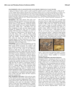
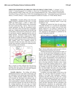
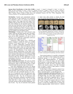
Swiss Bull. angew. Geol.
Vol. 15/2, 2010
S. 3-21
A crustal-scale magmatic system from the Earth's mantle to the
Permian surface − Field trip to the area of lower Valsesia and
Val d’Ossola (Massiccio dei Laghi, Southern Alps, Northern Italy)
Peter Brack1, Peter Ulmer1, with a contribution by Stefan M. Schmid
This field guide was born out of an excursion of the
Swiss Association of Petroleum Geologists and
Engineers on the occasion of its Annual Convention
at Stresa (June 2010). The visited area includes the
lower parts of Valsesia and Val d’Ossola and the
itinerary includes geological stops that are easily
accessible and at low altitudes (and thus ideal for
excursions in spring and in autumn). Additional
points of interest in the same area are located in Val
Mastallone and in Val Strona. With fair weather,
especially with northerly winds, a trip to Mottarone
between Lago Maggiore and Lago d’Orta is highly
recommended. Mottarone offers spectacular views
to the high peaks of the Valais Alps and across the
Po Plain towards the Ligurian Alps and the Apennines. On the ridges and slopes immediately southwest of the Mottarone summit road good outcrops
of the composite Baveno granite body and its contact aureole occur. Besides the points of geological
interest the area hosts numerous exceptional cultural sites such as the remarkable Sacro Monte di
Varallo (geological stop 3) and the village of Orta.
1. The Southern Alps: a short
introduction
Geologically, the «Southern Alps» comprise a
more than 400 km long portion of the Alpine
chain extending from the town of Ivrea
(Piemont) to the mountains of Carnia in
Friuli (Northeast Italy). The Periadriatic or
Insubric Line marks the border between the
Southern Alps and the nappe piles of the
Western, Central and Eastern Alps (Fig. 1).
The Alpine orogeny imposed a metamorphic
overprint reaching upper amphibolite-facies
grade, especially on the rocks of the Central
1
Departement Erdwissenschaften, ETH Zürich,
CH-8092 Zürich, Switzerland
Alps. Lithologies of the adjacent Southern
Alps were not affected by this metamorphism, but do record substantial Alpine tectonic deformation. In different phases the
South Alpine realm, or portions of it, were
compressed to form a south- to southeastvergent fold- and thrustbelt. East of Lago
Maggiore the average width of the deformed
area is around 60 km with the most external
structures known from the subsurface of the
Po Plain east of Milano. Thrusting involved
both metamorphic basement and cover
rocks. Estimates of the total shortening
range between 60−120 km. In the western
part of the Southern Alps this deformation
was achieved in at least two prominent
phases, before emplacement of the 42−33
Ma-Adamello intrusions, and after this event
during the Miocene. In the subsurface of the
western Po Plain the external thrusts and
folds are truncated by the Messinian unconformity, whereas in the eastern part of the
Southern Alps (Veneto, Friuli) tectonic
deformation remained active until present.
The Southern Alps originally belonged to the
northern border area of the Adriatic (Apulian) plate, and their alpine compression is
ultimately a result of the north- and westdirected movement and rotation of this
plate.
In transects across the Southern Alps west
of the Adamello intrusion the following
domains are encountered from north to
south:
• The innermost portion immediately south
of the Insubric Line consists of (Variscan)
greenschist to amphibolite facies metamorphic ortho- and paragneisses, with
3
Fig. 1: Geological sketch of the westernmost Southern Alps and of the tectonic units of the Central and
Western Alps. The black frame outlines the geological map of the Massiccio dei Laghi as in Fig. 3 (see this
figure for a legend of the South Alpine units).
4
presumably early Paleozoic protoliths,
which in places are cut by Permian intrusions. Permo-Mesozoic cover-rocks locally
occur as thin slivers between different tectonic slices of basement units. In a corresponding portion of the easternmost
Southern Alps (Carnia), Ordovician to Carboniferous sediment successions are preserved without significant metamorphic
overprint, but are affected by Variscan and
Alpine deformation.
• A belt of detached sedimentary units consisting of Permian clastic and volcanic
rocks and Mesozoic sediments forms a
wide area between the basement units to
the north and the recent clastic rocks of
the Po Plain. The youngest exposed folded
sediments are Cretaceous Flysch deposits
in the Bergamask sector.
• Molasse-type sediments (Gonfolite Group)
are occasionally visible in several places
along the southern border of the Alps,
forming south-dipping slices that may
have been lifted due to «hinterland»-directed local thrusts.
• In the subsurface of the northern Po Plain
the deformed part of the Tertiary clastic
fill increases in thickness with increasing
distance from the Alps. This also holds
true for the undeformed Plio-Pleistocene
deposits above the Messinian unconformity. Around Milano the base of the Pliocene
is currently at a depth of 2.5 km. Subsidence evidently decreased towards the
rising Alps, and close to the present border of the mountain chain the unconformable cover of marine Pliocene sediments is preserved up to an altitude of
500 m (e. g., at Monte S. Bartolomeo, west
of Lake Garda).
The Massiccio dei Laghi: a window to depth
The Massiccio dei Laghi (Serie dei Laghi and
Ivrea-Verbano Zone) between Biella and
Lago di Como belongs to the internal part of
the westernmost Southern Alps and contains rocks of the South Alpine upper and
lower crust. To the southeast the upper
crustal basement is bordered by an irregular
array of Permian volcanic rocks and Mesozoic sediments. The latter disappear under
the young clastic deposits of the Po Plain.
The detailed architecture of the Massiccio
dei Laghi and, in particular the Alpine
geometries, are still a matter of debate. Away
from the Insubric Line prominent large and
small-scale structures within crustal rocks
predate the Permian intrusions, thus showing that this area remained intact during Tertiary uplift. Results of gravimetric and seismic tomography studies suggest that the
dense rocks of the deep portion of the visible
South Alpine crust (i.e. the Ivrea-Verbano
Zone) are close to the tip of a body of dense
rock that rises steeply from the northwestern portion of the Adriatic mantle at normal
depths west of Milano (Fig. 2). Hence, the
overall geometry of the Massiccio dei Laghi
is indeed that of a southeastward tilted segment of the South Alpine crust.
In map views (Figs. 1, 3) the assembly of lower and upper crustal rocks can be observed
over 50 km in a SW-NE direction, with an
average width of approx. 25 km. This provides a unique situation of an extended 2dcross-sectional view of continental crust.
The upper crust portion comprises the barely visible cover rocks along the border hills
and different gneiss units and schists of the
Serie dei Laghi, which are cut by plutons of
Early Permian age. In its outermost and shallowest part, this sector dips gently towards
the Po Plain. Towards the deeper portion its
inclination likely increases. The contact
between the upper crust and the lower crust
(Ivrea-Verbano Zone) is tectonic and marked
by segments of the Cossato-Mergozzo-Brissago (CMB) Line and of the Pogallo Fault
Zone (PFZ). The CMB-Line is a high-temperature shear zone that was active until the
period of Permian magmatism. The PFZ is
most likely a mid-crustal extensional fault
related to Jurassic extension as it dissects
the CMB-Line, and because it was active at
lower temperatures.
5
The lower crust portion of the Ivrea-Verbano
Zone consists of a heterogeneous assembly
of high-grade metamorphic rocks, predominantly mafic intrusives and mantle slices.
Minerals and their compositions from both
metapelitic
lithologies
(«Kinzigites»,
«Stronalites») and the metabasic rocks are
indicative of high-temperature metamorphic
re-equilibration at amphibolite to granulitefacies conditions. Metamorphic pressures
increase towards the northwest, with
inferred pressure-gradients indicating that
this part of the crustal section is both tilted
upright and shortened. This is in agreement
with the orientation of steeply dipping (originally horizontal) magmatic layers in the
mafic intrusive rocks. Prominent slices of
mantle peridotites (e. g., Finero, Premosello,
Balmuccia) are found in the northwestern
border area of the Ivrea-Verbano Zone, cor-
responding to the deepest exposed crust
portion. As indicated above, the shape of
the gravimetric Ivrea-body at depth suggests that coherent mantle material reaches
near-surface levels beneath the Ivrea-Verbano Zone.
Two main factors may have contributed to
this peculiar crustal section being visible at
the Earth's surface:
• During the Jurassic-Cretaceous, i.e. prior
to the Alpine collision and compression,
the sector of the Massiccio dei Laghi was
situated on the distal portion of a passive
continental margin, close to the continentocean-transition between the Adriatic
plate and the Piemont-Liguria ocean to the
NW (in present orientation). The continental crust of the Southern Alps and, in particular of its westernmost portion, had
been stretched prior to the continental
Fig. 2: a] Schematic geophysical-geological cross section through the western part of the Central Alps and
the adjacent Southern Alps. Circles mark well-locatable earthquake foci for the 1980-95 time period from
within a 30 km wide corridor projected onto the transsect. See Fig. 1 for the trace of the section. b] Vertical cross section based on results of seismic tomography along the SE part of the CROP-transsect (parallel but southwest of section Fig. 2a). The maximum resolution capabilities of the seismic tomography model is about 10 km. Blue and red colours: high and low velocity perturbations respectively. Ma – Adriatic
Moho; Me – European Moho; LCe – European lower crust. Figures modified after Schmid & Kissling 2000.
6
Fig. 3: Geological map of the Massiccio dei Laghi west of Lago Maggiore (Ivrea-Verbano Zone and Serie dei
Laghi; simplified after a compilation by T. James 2001). The proposed field trip itineraries and stops are
indicated: crustal section and mantle rocks in Valsesia (squares), upper and lower crustal rocks in Val
d'Ossola (circles).
7
break-up separating Adria from Europe.
Due to extension, the crust-mantle boundary at the base of the Ivrea-Verbano Zone
likely rose from an original depth of > 30
km in Permian times to around 25−30 km
after the Early Jurassic.
• During Alpine collision the underthrusting
of less dense material at depth beneath
the present Ivrea-body and the backthrusting of shallow portions induced the
formerly extended South Alpine crust and
upper mantle portion to rise further, eventually reaching the surface.
Reconstruction of the Lower Permian crust
Prior to the opening of the Piemont-Ligurian
ocean, the South Alpine realm, including the
Massiccio dei Laghi, had been stretched at
different stages (during the Late Triassic −
Early Jurassic). The roughly E-W directed
extension (present orientation) produced
topographic lows and highs separated by discrete fault zones. Variable thickness and contrasting sedimentary environments (shallow
vs. deep basinal lithologies) of corresponding
stratigraphic intervals allowed the reconstruction of the 2d-geometry of numerous
platforms and basins along the strike of the
Southern Alps (Fig. 4). Moreover, some of the
bounding faults such as the Lugano-Val
Fig. 4: a] Lithospheric profile across the western part of the South-Alpine segment of the Adriatic passive
continental margin. PFZ: Pogallo Fault Zone; LMF: Lago Maggiore Fault; LF: Lugano-Val Grande Fault. Figure from Bertotti 1991. b] architecture of the South-Alpine continental margin during the Jurassic. Abbreviations as in Fig. 4a. Figure modified after Ferrando et al. 2004.
8
Fig. 5: a] Geological map of the Ivrea-Verbano Zone – Laghi area (see also Fig. 3) and b] corresponding
crustal-scale section depicting the situation after the Late Triassic – Early Jurassic extension (simplified
version of the restored cross section in Rutter et al. 1999). c] Schematic reconstruction of the crust for the
time of Early Permian magmatism. Figures b) and c) are modified after Schaltegger & Brack 2007.
9
Grande Fault (LF) can be traced into the
basement rocks and hence into deeper levels
of the upper crust. The PFZ in the Massiccio
dei Laghi is likely a similar fault that continues into the middle crust. Based on correlated lithologic markers the offset along this
fault is on the order of 10 km, with the hangingwall (i. e. eastern) part displaced towards
the (north-)east (Fig. 3).
The crustal section derived from the actual
distribution of rocks on the geological map
thus represents crustal geometry following
the Mesozoic extension, i.e. with a crustmantle boundary at shallower levels than
«normal» (Fig. 5a, b). Removal of the Mesozoic extension (such as the offset along the
PFZ) provides a first-order approximation of
the crust during the Permian magmatism
(Fig. 5c). In this reconstruction the crustmantle boundary lies at «normal» levels, in
agreement with metamorphic pressure indications from lower crustal rocks. This is
comparable with the distant but similar
crust-mantle assembly in Valmalenco, where
a fossil Adriatic Moho between lower continental crust and mantle rocks is crosscut
and tied together by Lower Permian gabbros.
The Lower Permian crust along the
Southern Alps
Lower Permian magmatic products in the
lower and upper crust of the Southern Alps,
and continental and marine deposits in near
surface settings, allow the reconstruction of
a several hundred kilometres long transsect
from a near-mantle level (basal portion of
Ivrea-Verbano Zone) to a coeval sea-level in
Carnia (Figs. 6, 7). The reconstruction is constrained to a narrow time interval between
285−275 Ma, corresponding to the occurrence of coeval rocks across the entire area.
In Carnia the stratigraphic successions of
Fig. 6: Distribution of pre-Lower Permian basement and cover rocks of the Southern Alps. The black frame
approximately marks the crustal section displayed in Fig. 5. Also indicated are Austroalpine areas with dated Lower Permian magmatic rocks (north of Insubric Line). Figure modified after Schaltegger & Brack
2007.
10
the uppermost Carboniferous to lowermost
Permian unconformably overlie deformed
but non-metamorphic older Paleozoic rocks.
In the Southern Alps west of Carnia the corresponding pre-Carboniferous protoliths
were thrust and metamorphosed during
Variscan deformation. Before the Late Carboniferous the currently exposed basement
rocks had cooled, exhumed and carry locally preserved covers of Upper Carboniferous
conglomerates (e. g., Manno near Lugano).
In Carnia the marine post-Variscan succession spans an interval straddling the Carboniferous/Permian-boundary, up to the
Artinskian. In the central and western South-
ern Alps Lower Permian rocks occur as volcano-sedimentary fills of asymmetric continental basins (Orobic and Collio Basins) and
volcano-tectonic depressions (290−275 Ma).
Only during the Late Permian was a smooth
topography east of Lake Como covered by
widespread alluvial plain deposits (red conglomerates and sandstones of the Verrucano
Lombardo − Gröden Sandstone). In the latest Permian to Early Triassic a shallow sea
invaded the area from east to west.
Fig. 7: Synthetic E–W cross section of the Lower Permian crust of the Southern Alps with U-Pb age results
(Zr *: SHRIMP zircon data from Quick et al. 2003, 2009; Zr: ID-TIMS zircon data from Schaltegger & Brack,
2007; Zr ”: U-Pb zircon data from Marocchi et al. 2008; All: U-Pb allanite data from Barth et al. 1994) and
selected Rb-Sr age data of Lower Permian magmatic rocks (see Schaltegger & Brack 2007 for further references). Mesozoic extension on major fault zones (Lago Maggiore Fault, Lugano Fault, border areas of
Trento platform) has been removed. Color code of Ivrea-Laghi crust section as in Fig. 3; undifferentiated
upper crustal metamorphic basement (grey area) and little to non-metamorphic pre-Moscovian successions of Carnia (light grey) are indicated schematically. Red colors mark plutonic and volcanic rocks; nonvolcanic sedimentary basin fills comprise mainly fluviolacustrine clastic rocks (light blue) coarse alluvial
deposits (yellow) and in Carnia, marine carbonates and clastics (dark blue). Note change of vertical scale
corresponding to ca. 7 km depth-level. Complementary age information from Austroalpine units is shown
in the inset; pressure at petrologic crust/mantle boundary of Malenco Unit at the time of intrusion of the
Braccia Gabbro is constrained by metamorphic and magmatic mineral assemblages to around 1.0 GPa
(Hermann et al. 2001). Figure modified after Schaltegger & Brack 2007.
11
Magmatic products and geodynamic
szenarios for the Early Permian
Near-surface and upper crustal intrusions of
Early Permian age are concentrated in two
realms along the Southern Alps (Fig. 6): the
Athesian (Etsch) district to the east (Cima
d'Asta, Brixen) and in the Verbano province
to the west, i. e. between Biella and the surroundings of Lake Lugano (e. g., Alzo-Roccapietra, Baveno, Cuasso al Monte). Both
areas also correspond to prominent centres
of Permian volcanic activity, but only the
crustal section across the Massiccio dei
Laghi and its cover rocks (in Valsesia)
exposes the complete magmatic system
which ranges from voluminous mantlederived basic intrusions into the lower
crust, to coeval volcanic products (lavas,
ignimbrites, volcanoclastic rocks) at the
Earth's surface (Figs. 3, 5). However, the
Lower Permian crust reconstructed for the
Massiccio dei Laghi is likely representative
also for other areas with similar near-surface magmatic products.
The formation of basic mantle-derived melts
such as those which led to the formation of
gabbros and diorites in the lower crust of
the Ivrea-Verbano Zone (and in the Malenco
unit of the Eastern Alps) is usually related to
decompression of mantle material above a
rising asthenosphere. A popular theory
states that such upward movement of mantle material could result from the post-orogenic gravitational collapse of an overthickened crust, such as the Variscan orogen.
Alternatively a rising asthenosphere could
generate an active rift, but a passive rift with
transtension in connection with crust-scale
strike-slip might also induce upward
motions of portions of the deep mantle.
Recent paleomagnetic results from Permian
rocks in the Southern Alps and other AdriaGondwana portions indeed suggest a profound reorganization of Pangea during the
Permian: from an Early Permian «Pangea-B»
to a Late Permian/Triassic (Wegnerian)
«Pangea-A». In this model the short (10−15
12
Ma) phase of extension and formation of
Lower Permian basins and associated magmatic products could correspond to the initial stage of rifting just prior to the onset of a
large-scale strike-slip translation. In this
reconstruction for the Early Permian, the
realm of the Southern Alps belongs to Gondwana and would have been situated several
thousand kilometres east of the present
position relative to Central Europe and Russia, i. e. somewhere southeast of the present
Caspian Sea (for details see Muttoni et al.
2003).
2. Field trips
Between Valsesia and Val d’Ossola the Massiccio dei Laghi exhibits two significantly different crustal sections (for itineraries and
proposed stops see Fig. 3):
• The Valsesia section provides insight into
the shallowest (volcanic) and the deepest
portions of the crustal-scale Lower Permian magmatic system. The excursion follows the Sesia River between Romagnano
and Balmuccia.
• The Val d'Ossola section allows the study
of upper crustal intrusions and a variety of
lithologies and structures in the lower
crust, with only scarce Permian magmatic
rocks.
2.1 The Valsesia transsect
Valsesia in its lower part between Romagnano southeast of Grignasco and Balmuccia
crosses a complete section of crustal rocks
ranging from Lower Permian volcanic rocks
that erupted at the Earth's surface (stops 1,
2) through coeval upper crustal granite plutons to an enormous volume of mafic intrusive rocks in the lower crust (stops 3, 4) and
in direct contact with deep seated mantle
lithologies (stop 5). The following paragraphs provide a short outline of the petrologic and geochemical characteristics of the
main units.
Permian granitoids and associated
volcanic rocks
In the excursion area, several Lower Permian granitoid plutons with ages coeval with
the «Mafic Complex» of Valsesia-Val Sessera
crop out; the most voluminous complexes
are (from southwest to northeast): Valle
Mosso Granites, Alzo-Roccapietra Granite
and Baveno/Mottarone Granite/Granodiorite. These mid to upper crustal granites are
biotite − two feldspar granites and granophyres, geochemically identified as metaluminous granites with isotopic characteristics indistinguishable from the «main gabbros» of the «Mafic Complex». The plutonic
granitoids are accompanied by volcanic
products, dominantly re-sedimented explosive tephra deposits, with minor lava flows
and plugs of predominantly rhyolitic to rhyo-
dacitic composition. The majority of outcropping volcanic deposits are non to poorly welded chaotic, unsorted «tuffs» representing volcaniclastic mass flow deposits
that can either be interpreted as poorly
welded ignimbrites (ash-flow tuffs), lahars
(volcanic mud-flow deposits) or breccias
formed by land-slides from the collapse of
instable caldera walls (stop 1 [N 45°41’18”,
E 08°19’27.9”]: roadcut northwest of Grignasco; Lower Permian volcaniclastic rocks
with clasts of folded basement schists of the
Scisti dei Laghi, Fig. 8a). Common feature of
these deposits are the lack of sorting, grading or stratification, the presence of angular
fragments of both volcanic (e. g., lapilli and
lava, juvenile and lithic) and country rock
(basement and granites) origin, dispersed in
a fine-grained (muddy, ash-rich) matrix
inferring the presence of water during depo-
Fig. 8: a] Lower Permian volcaniclastic «tuff» at
Grignasco (stop 1) composed of unsorted angular
fragments of country rocks (basement schists,
granites) and volcanic clasts (lava and lapilli) in a
fine grained «muddy» matrix consisting of altered
volcanic ash. b] Folded banded obsidian at Crevacuore (stop 2) forming a lava flow; banding represents alternating degassed (obsidian) and foamed
(pumice) layers of rhyolitic glass; folding is igneous
and produced during deformation of slowly advancing lava flows (or plugs). c] Banded obsidian at
Crevacuore (stop 2); brecciation of banded lava at
the tip of highly viscous lava flow caused by cooling
at the surface and internal shearing during movement.
13
sition. These «tuff» deposits are typical for
high silica, explosive Plinian eruptions
potentially associated with the formation of
large caldera structures and subsequent
remobilization of primary tephra (fallout
and ignimbrite). Minor lava flows forming
short flows and plugs of (banded) obsidian
locally accompany the volcaniclastic sediments (stop 2 [N 45°41’23.2”, E 08°15’26.4”]:
Crevacuore [turnoff to Guardabosone]; Lower Permian banded rhyolites, Figs. 8b, 8c).
Geochemical and isotope geochemical characteristics of the Permian igneous products
are typical for extensional magmatic systems comparable to present-day igneous
systems in the Western US, e. g., the Basin
and Range province. Such magmatic systems are characterized by bi-modal magmatism dominated by tholeiitic basaltic (gabbroic) and rhyodacitic-rhyolitic (granodioritic-granitic) compositions and extensive
interaction with crustal lithologies by assimilation–fractional crystallization processes
producing isotopic signatures intermediate
between purely mantle and crustal derived
source compositions respectively. High resolution U-Pb age dating of igneous zircons
(Fig. 7) reveals that the lower crustal gabbroic rocks, the mid to shallow crustal plutonic granitoids and the acidic volcanics are
coeval around 280−285 Ma with some granites extending to slightly lower ages of about
275−280 Ma testifying to the existence of a
large scale, complex igneous system encompassing the entire crustal column.
The Kinzigite Formation and the
«Mafic Complex»
The Kinzigite Formation represents a preVariscan volcano-sedimentary succession
with predominantly metapelitic sedimentary protoliths metamorphosed under amphibolite- to granulite-facies conditions. Rarely
also arenaceous metasediments and marbles occur. The igneous component is
basaltic, actually transformed into amphibolite and pyribolite (a granulite-facies meta14
morphic rock containing pyroxene, amphibole and plagioclase). Amphibolite- and
granulite-facies metamorphic mineral
assemblages record temperatures lower
than 600°C and higher than 800°C and pressures between 0.4 – 0.7 and 0.6 – 1.1 GPa
respectively. The transition between the two
metamorphic zones is rapid and often tectonic, marked by high-temperature shear
zones.
The «Mafic Complex» intrudes the Kinzigite
Formation (Figs. 3, 5) and primary contacts
are preserved locally. It reaches its maximum thickness of around 11 km in the southern part of the Ivrea-Verbano Zone, along
Valsesia. Primary igneous features (layering,
intrusive contacts, magma mingling, more
rarely textures) are generally preserved. All
igneous rocks of the «Mafic Complex» underwent slow isobaric cooling which induced
re-equilibration of the primary igneous
phases, resulting in the common occurrence
of granoblastic and coronitic textures and
unmixing in coexisting low- and high-Ca
pyroxenes. Re-equilibration pressures have
been estimated to vary between 0.5 and 0.8 –
0.9 GPa from the roof to the bottom of the
«Mafic Complex». The complex represents
an enormous magma system in the lower
crust that grew during continuous input of
mantle-derived magma during extensional
tectonics (mantle uplift with partial melting)
in a relatively small stationary magma chamber of estimated 4 × 1 km in size. Concomitant large-scale ductile deformation of the
complex and transport of cumulates downward and outward from the magma chamber
occurred as a consequence of extensional
tectonics. The Valsesia section exhibits the
most complete «stratigraphy» and major
thickness of the various lithological units
consisting, from top to bottom, of a an upper
dioritic zone (diorite units) in contact with
the metasedimentary rocks, a virtually
homogenous gabbro (main gabbro) and a
layered series of cumulus rocks in contact
with the mantle rocks of the Balmuccia
body.
At Sacro Monte di Varallo (stop 3a
[N 45°49’12.5”, E 08°15’32.2”]) folded Kinzigitgneisses with marble streaks are exposed
along the access road immediately northeast of Sacro Monte. They represent the rooflevels of the «Mafic Complex» whose garnetbearing diorites form the hill of Sacro Monte
s. s. (stop 3b [N 45°49’5.8”, E 08°15’20.6”] in
front of the basilica).
A much deeper level inside the «Mafic Complex» is well exposed on the south bank of the
Sesia River, ca. 400 m west of the small village
of Isola di Vocca (stop 4 [N 45°49’31.9”,
E 08°09’55.5”]) exhibiting stratified gabbroic
and pyroxenitic rocks of the intermediate
zone of a layered series with conspicuous
compositional layering and syn-magmatic
deformation structures (shearing, faulting
and folding; Fig. 9a). The main lithologies are
gabbro-norites and websteritic pyroxenites.
Mantle Peridotites: The ultramafic body of
Balmuccia
The largest and best known peridotite units
in the Ivrea-Verbano Zone are from south to
north the Baldissero, Balmuccia and Finero
bodies (Fig. 3; labeled as ultrabasic rocks).
These bodies are aligned close to the northwestern margin, i. e. in the «stratigraphically» deepest part of the Ivrea-Verbano Zone.
Minor bodies of peridotite, recognized as
lithospheric upper mantle material, also
occur at other stratigraphic levels. The peridotite bodies display different petrologic
characteristics (composition, degree of
depletion, metasomatic overprint) documenting a heterogeneous South Alpine
(Adriatic) lithospheric mantle. The Baldissero and Balmuccia massifs are the least
depleted (most fertile, lherzolitic) and least
metasomatized lithologies, whereas the
Finero peridotite is highly depleted
(harzburgitic) and has been pervasively
metasomatized by late K-rich fluids, possibly during extension in the Late Triassic.
The Balmuccia ultramafic body between
Valsesia and Val Mastallone has the shape of
an elongated, NNE-trending lens, 5 km long
and with a maximum width of 0.8 km. To the
west the body is sheared by the Insubric
fault system and in tectonic contact with
mylonitized members of the «Mafic Complex» or with metasediments of the Kinzigite
Fig. 9: a] Layered gabbro-norites (two pyroxenes, plagioclase) at Isola (stop 4; layered series of the «Mafic
Complex»): The layering consists of plagioclase-rich and dark pyroxene-rich strata. Folding is syn-magmatic, most probably representing «slump-folds» in partly solidified cumulate layers at the floor or along
the wall of a magma chamber. b] Balmuccia peridotite (stop 5): Crosscutting relationship between a first
generation of Cr-diopside vein (green) cut and offset by a later dyke of Al-augite websterite (2-pyroxene +
spinel, grey) in lherzolite. Second generation dykes can possibly be attributed to magmas feeding the overlying «Mafic Complex».
15
Formation. To the east, the peridotite is in
igneous contact with the basal zone of the
«Mafic Complex». Balmuccia is a very fresh
peridotite. The dominant rock-type is a
clinopyroxene-poor spinel-facies lherzolite
(Fig. 10). Harzburgitic or dunitic compositions are rare and mostly occur at the contacts of pyroxenite dykes or in layers along
with spinel streaks. Amphibole is present in
trace amounts, phlogopite is basically
absent, except in a few places along the eastern contact.
Pyroxenite dykes form approximately 5 % of
the Balmuccia outcrops. The dykes can be
distinguished into a Cr-diopside and an Alaugite suite (Fig. 9b). The Cr-diopside suite
is composed of at least three generations of
dykes and their thickness varies from less
than 1 cm to about 1 m. They consist of websterites bearing clinopyroxene, orthopyroxene, spinel and minor olivine. In the field
Cr-diopside dykes are recognized by the
intense green color of the Cr-bearing
clinopyroxenes. The Al-augite dykes are up
to 1.5 m thick, have a gray color and abundant spinel reaching up to 20 %. Apart from
spinel, they consist of Cr-poor clinopyroxene, orthopyroxene and sometimes amphibole. Several dyke generations can be distinguished on the basis of crosscutting relationships and all of them are younger than
the Cr-diopside suite.
In general, the Cr-diopside dykes record all
the deformation episodes of the host peridotite. They show the same foliation and,
when discordant, they are folded with axial
planes parallel to the peridotite foliation. Alaugite dykes are syn- to post-kinematic with
respect to the older foliation. Only the latest, black Al-augite dykes and associated
gabbro pods do not show signs of deformation. These relationships suggest that the
different generations of dykes record distinct episodes ranging from the accretion of
asthenospheric mantle material to the lithosphere to the emplacement of such mantle
lithosphere at the base of the crust. The age
of these processes is unknown but assumed
to be much older than the Lower Permian
magmatism.
The cliffs of both riverbanks south of Balmuccia (stop 5 [N 45°49’11.3”, E 08°09’10.0”])
Fig. 10: Modal composition of
Ivrea-Verbano Zone peridotites
(Val Strona rocks include samples from Alpe Piumero, Alpe
Francesca, Alpe Crotta). Figure
modified after Rivalenti & Mazzucchelli 2000.
16
exhibit variable textures of the peridotite,
the relationships between the Cr-diopside
and Al-augite dykes and between dykes and
peridotite. The dominant peridotite lithology
is lherzolite, except in the contact regions of
the dykes as well as in dunitic or harzburgitic
layers containing spinel trails. These latter
are interpreted as the refractory remnants of
Cr-diopside dyke melting. Texture is foliated,
locally porphyroclastic to proto-granular.
Various generations of Cr-diopside and Alaugite dykes are easily distinguished on the
basis of intersections. Cr-diopside dykes
vary from concordant to discordant with
respect to the peridotite fabric and dykes are
sometimes ptygmatically folded. Al-augite
dykes cut all the Cr-diopside dykes and are
less or not deformed. Black veins of pseudotachylites occasionally cross all lithologies.
2.2 The Val d'Ossola transsect
The rocks exposed between Lago Maggiore
and the Insubric Line in the lower part of Val
d'Ossola comprise the deeper part of the
upper crustal Serie dei Laghi and the IvreaVerbano Zone (Fig. 3). Prominent Lower Permian granite plutons (Baveno, Mont'Orfano)
occur in the upper crust (i. e. east of the
CMB-Line and Pogallo Fault Zone) whereas
coeval magmatic rocks are subordinate in
the lower crust of this transsect. There, the
largely pre-Permian metamorphic lithologies and the structure of the lower crust are
preserved and provide insight into the architecture of a «magma-poor» deep portion of
the South Alpine crust.
The Serie dei Laghi and Permian
granite plutons
The Serie dei Laghi comprises a series of
metasedimentary schists and gneisses with
occasional amphibolite sheets that are cut
by orthogneisses of Ordovician age. The outcrops of the rocks of the Strona-Ceneri unit
form a distinct tract comprising CeneriGneiss, Gneiss Minuti and other gneisses
with amphibolites and ultramafic rocks of
the Strona-Ceneri border zone. Along the
Pogallo Fault Zone northeast of Omegna the
outcrops of this tract are displaced by about
14 km (Fig. 3). The rocks of the Serie dei
Laghi were folded at least twice on a range of
scales but only the last (local) folding event
(open folds) may be geometrically correlated with late folding in the Ivrea-Verbano
Zone. Apparently undeformed gabbrodioritic rocks of Permian age seem to cut the Cossato-Mergozzo-Brissago (CMB) Line. Therefore the Permian stretching and magmatism
probably postdates all folding events. All
structures and also Permian magmatic rocks
are cut by the Pogallo Fault Zone (PFZ).
The Serie dei Laghi hosts undeformed
granitic intrusions of Permian (275 – 285 Ma)
age, which range in diameter from 1 km to
more than 10 km (Figs. 3, 5, 7). In the region
east of the main granitic bodies the dominant schistosity of the metasediments of the
Serie dei Laghi dips gently (ca. 25°) towards
the southeast. The Baveno body itself shows
evidence for moderate post-Permian tilting.
Immediately to the west of the granite intrusions but also towards the PFZ the host rock
schistosity becomes vertical.
At stop 6 ([N 45°56’19.3”, E 08°26’29.8”] small
quarry on the western slope of Mont’Orfano)
the Lower Permian white granite of Mont'Orfano (U/Pb-zircon age: 281.8 ± 1.5 Ma; Schaltegger & Brack 2007) can be studied in outcrop. Mont'Orfano and the pink and white
granites between Baveno and Omegna (Mottarone) most probably belong to the same
intrusive suite. Typical mica-schists of the
surrounding Serie dei Laghi are exposed
between the railway line and the main road
at Mergozzo; stop 7 [N 45°57’39.8”,
E 08°26’39.6”].
The Ivrea-Verbano Zone
The Ivrea-Verbano Zone (Figs. 1, 3) is dominated in its lower metamorphic grade (i. e.
south-eastern) portion by a thick unit of
variably migmatized metasedimentary
17
schists (garnet, biotite, plagioclase, quartz,
sillimanite and muscovite), known as the
Kinzigite Formation. This unit forms a strikingly continuous and uniform interval about
2 – 4 km wide along the entire length of the
visible part of the Ivrea-Verbano Zone. In a
northwestern direction the metamorphic
grade increases and the metasedimentary
rock texture changes due to progressive
replacement of muscovite and biotite by sillimanite, K-feldspar and garnet. The schistose lithologies grade into more massive
banded migmatitic gneiss, known locally as
«Stronalite». In the middle portion of the
Kinzigite Formation a heterogeneous group
of variable metasediments occurs. An apparent «stratigraphic» succession comprises
the quartz-feldspatic gneisses at the top, followed by a quartzite layer, then marbles,
metapelites and marls. Below is a thick
quartz-feldspatic and metapelitic layer followed by interlayered bands of amphibolite,
between 1 – 10 m thick. These latter have
been interpreted as mafic lavas or intrusions
within an early (Palaeozoic) pelitic accretionary complex. Finally, there are up to 1
km thick streaks of banded and massive
amphibolite (e. g., big blocks in the gorge
behind the small village of Nibbio
[N 45°59’52.2”, E 08°23’41.8”]).
Rocks exposed along the road from Candoglia to Cava Madre (Fig. 11a, b) comprise
several layers of marble and quartzite,
Kinzigit-gneiss and pegmatites. The exploited marble layer forms a narrow band of relatively coarse-grained white to pink calcitemarble with dm-thick layers of calc-silicate
and amphibolite. The latter show spectacular boudinage structures. Streaks of sulfides
(pyrite, chalcopyrite) are unwelcomed
impurities. The Candoglia marble layer is
possibly a folded isoclinal fold with its uphill
termination at approx. 900 m altitude. Close
to the office of the quarry workings at Candoglia [N 45°58’33.9”, E 08°25’20.9”] a marble
model shows the concession owned by the
«Veneranda Fabbrica del Duomo di Milano».
Since the 14th century this marble has been
exploited and used as the main building
stone of the dome of Milano. Taking advantage of a wide network of canals (Naviglio
Grande; Fig. 1) river boats managed to transport the rock material from the quarries to
the immediate neighbourhood of the majestic dome in the historical centre of Milano.
Currently the main excavation activities are
at Cava Madre (Fig. 12) where workings
started around 1800.
The quarries at Candoglia are not open for
the public. However, along strike, on the
Fig. 11: a] Migmatitic biotite-rich Kinzigite gneiss on a cut surface along the road close to Cava Madre at
Candoglia. Undeformed white leucosomes cut the folded schistosity of the gneiss and consist of coarse
feldspar, quartz and tourmaline. b] Boudinaged amphibolite layer in a matrix of calcite-marble on the floor
surface at Cava Madre as in 2010.
18
opposite flank of Val d'Ossola the corresponding layer is found to continue above the village of Ornavasso. Similar marbles also occur
in the Kinzigit-gneisses in Val Strona southwest of Val d'Ossola. At stop 8 [N 45°58’08.5”,
E 08°24’10.4”] in a hair-pin bend along the
road from Ornavasso to the Sanctuary of the
Madonna del Boden the entrance of an old
abandoned underground excavation of «Candoglia marble» is visible. The San Nicolao
church along the same road [N 45°58’05.8”,
E 08°24’27.3”] is a prominent edifice made of
this local marble.
The traverse along Val d‘Ossola displays the
curious arrangement of large antiformal
structures in succession, each several kilometres in amplitude but without any obvious synformal structures in between (e. g.,
Massone antiform in Fig. 12). On the SE limb
of the major Massone fold structure, peg-
matitic granitoid sheets occur in concordant
and discordant lenses up to a few tens of
metres thick and a few hundred metres long.
The coarse-grained pegmatitic pockets and
sheets are supposed to be of Permian age.
The Massone folding predates the intrusion
of the «Mafic Complex» of Valsesia, which at
least locally produced sufficient heat to
cause migmatization (Fig. 11a) and granulite
facies metamorphism in the surrounding
metasediments. However, the episode of
melting that is striktly related to the «Mafic
Complex», is superimposed on an earlier
episode of regional metamorphism and it is
as yet unclear whether all the migmatization
and degranitization of metapelitic rocks
observed in this region is due to the thermal
effects of the hot basic magmas of the «Mafic Complex» and its possible northeastern
extensions.
Fig. 12: View of the eastern flank of Val d'Ossola looking from the San Nicolao church above Ornavasso.
The traces of the Massone fold and of the main marble layer at Candoglia are indicated. The marble band
is folded, terminates uphill and possibly represents a refolded isoclinal fold illustrating the multi-phase
nature of the structures in the Ivrea-Verbano Zone. All these structures are cut by predominantly NW-SE
oriented white pegmatites of supposed Early Permian age.
19
Towards the northwestern border of the
Ivrea-Verbano Zone, sheet-form or lensoid
ultramafic bodies include lherzolites,
dunites and pyroxenites (Fig. 10). Although
prominent lenses such as the one at Premosello [N 46°00’19.9”, E 08°19’09.6”] are
undoubtedly of upper mantle origin, the
ultramafic sheets may have been detached
from the mantle and are tectonically incorporated into the lowermost part of crustal
rocks.
Lithologies typical for the deeper part of the
lower crust (Ivrea-Verbano Zone) in the
Ossola transsect comprise ganulite-facies
metapelites («Stronalites», with garnet and
sillimanite), garnet-bearing metabasic rocks
and peridotites. Spectacular blocks of these
rocks can be studied in a river bed at Rumianca (stop 9 [N 45°59’35.4”, E 08°17’31.5”]).
The Insubric «Line» (by S. M. Schmid)
Insubric «Line» is a misnomer in that there is
no sharp line between the Southern Alps (in
our area represented by the Ivrea-Verbano
Zone) and the southern steep belt (or «root
zone») of the nappe pile of the Central Alps.
In fact it is a some 1000 m thick belt of
mylonites that accompanies complex differential movements between the Southern
Alps and the Central Alps. The latter are
back-thrusted to the SE to S, with a vertical
component of displacement that reaches 20
km in the Ticino area. At the same time some
of the mylonites, namely those immediately
adjacent to the Ivrea-Verbano Zone, also
accommodated significant dextral strikeslip. Combined back-thrusting and strikeslip movements occurred between about 35
– 20 Ma ago. After 20 Ma ago pure dextral
strike-slip was still ongoing, but manifested
itself by exclusively brittle faulting that is
confined to the Jorio-Tonale Line east of
Locarno and the Centovalli Line north of the
SW part of the Insubric Line in Val d'Ossola.
The chapel of Loro (stop 10 [N 45°59’54.8”,
E 08°16’49.5”]) is right at the contact
between massive mafic rocks, marbles and
20
ultramafic rocks of the Ivrea-Verbano Zone
(only with signs of alteration in the immediate surroundings; exposures along trail
south of chapel) and an approx. 1000 m wide
belt of Insubric mylonites north of the
chapel. This sharp contact, referred to as
«fabric boundary», separates the well preserved pre-Mesozoic fabrics found south of
the chapel from the alpine-age fabrics within
the Ivrea-derived mylonites north of the
building. The mylonites were syn-tectonically retromorphosed under greenschist facies
conditions, the complete break-down of the
granulite to amphibolite facies parageneses
being a pre-requisite for penetrative alpine
overprint («reaction-induced strain softening»). The «fabric boundary» represents the
southern edge of the area that had sufficient
supply of water – a prerequisite for retromorphosis and mylonitization. Note that
there are no brittle features visible at all.
North of the Ivrea-derived mylonites follows
a thin band of dark calc-mylonites and
quartzitic mylonites ascribed to Mesozoic
rocks that once covered the northwesternmost part of the Southern Alps (Canavese
sediments). This is then followed by granitic
mylonites derived from the Sesia Zone.
From the chapel there is also a splendid
view to the eastern flank of Val d'Ossola.
South of the Insubric Line, the Ivrea-Verbano
Zone is characterized by the huge Alpineage Proman antiform. North of the Insubric
Line, the NW-dipping Insubric mylonites and
northerly adjacent banded gneisses of the
Sesia Zone contrast with the massive rocks
of the Ivrea-Verbano Zone.
Acknowledgments
We would like to thank the VSP/ASP Committee
and its President Peter Burri for inviting us to
attend the General assembly and lead the geological excursions on the occasion of the Annual Convention 2010 at Stresa. Moreover we would like to
thank VSP/ASP for the generous opportunity to
publish this field-guide in their bulletin and Daniel
Bollinger for his editorial efforts.
Our knowledge of the crustal transsects along
Valsesia and Val d’Ossola strongly benefitted from a
wealth of information provided by our former colleague and friend Luigi Burlini. With his profound
geological knowledge on his home area Luigi
helped us establish this and similar excursions that
we organized for ETH and other students. To his
memory this contribution is dedicated.
Figure sources and selected references
Barboza, S. & Bergantz, G. 2000: Metamorphism and
anatexis in the Mafic Complex contact aureole, Ivrea
Zone, Northern Italy. J. Petrol. 41(8): 1307−1327.
Bertotti, G. 1991: Early Mesozoic extension and
alpine shortening in the western Southern Alps:
The geology of the area between Lugano and
Menaggio (Lombardy, Northern Italy). Mem. Sci.
Geol. 43: 17−103.
Boriani, A., Burlini L., Caironi, V., Giobbi Origoni, E.,
Sassi, A. & Sesana, E. 1988: Geological and
petrological studies on the Hercynian plutonism
of Serie dei Laghi. Geological map of its occurrence between Valsesia and Lago Maggiore (NItaly). Rend. Soc. Ital. Miner. Petrol. 43: 367−384.
Boriani, A., Burlini L. & Sacchi, R. 1990: The CossatoMergozzo-Brissago Line and the Pogallo Line
(Southern Alps, Northern Italy) and their relationships with the late-Hercynian magmatic and metamorphic events. Tectonophysics 182: 92−102.
Ferrando, S., Bernoulli, D. & Compagnoni, R. 2004:
The Canavese zone (internal Western Alps): a
distal margin of Adria. Schweiz. Mineral. Petrogr.
Mitt. 84(3): 237−256.
Handy, M. R., Franz, L., Heller, B., Janott, B. & Zurbriggen, R. 1999: Multistage accretion and exhumation of the continental crust (Ivrea crustal
section, Italy and Switzerland). Tectonics 18:
1154−1177.
Hansmann, W., Müntener, P. & Hermann, J. 2001:
U-Pb zircon geochronology of a tholeitic intrusion and associated migmatites at a continental
crust-mantle transition, Val Malenco, Italy.
Schweiz. Mineral. Petrogr. Mitt. 81: 239−255.
Hermann, J., Müntener, O., Trommsdorff, V., Hansmann, W. & Piccardo, G. B. 1997: Fossil crust-tomantle transition, Val Malenco (Italian Alps). J.
Geophys. Res. 102(B9): 20123−20132.
James, T. 2001: A study of the geological structure
of the Massiccio dei Laghi (Northern Italy).
Unpubl. PhD Thesis, University of Manchester.
Marocchi, M., Morelli, C., Mair, V., Klötzli, U. & Bargossi, G. M. 2008: Evolution of large silicic magma systems: New U-Pb zircon data on the NW
Permian Athesian Volcanic Group (Southern
Alps, Italy). Journal of Geology 116: 480−498.
Monjoie, P., Bussy, F., Schaltegger, U., Mulch, A.,
Lapierre, H. & Pfeiffer, H. R. 2007: Contrasting
magma types and timing of intrusion in the Permian layered mafic complex of Mont Collon (Western
Alps, Valais, Switzerland): evidence from U/Pb zircon and Ar-40/Ar-30 amphibole dating. Swiss
Journal of Geosciences 100 (1): 125−135.
Muttoni, G., Kent, D. V., Garzanti, E., Brack, P.,
Abrahamsen, N. & Gaetani, M. 2003: Early Permian Pangea “B” to Late Permian Pangea “A”.
Earth Planet. Sci. Lett. 215(3−4): 379−394.
Peressini, G., Quick, J. E., Sinigoi, S., Hofmann, A.
W. & Fanning, M. 2007: Duration of a large mafic
intrusion and heat transfer in the lower crust. A
SHRIMP U/Pb zircon study in the Ivrea-Verbano
Zone (Western Alps, Italy). Journal of Petrology
48: 1185−1218.
Quick, J. E., Sinigoi, S., Snoke, A. W., Kalakay, T. J.,
Mayer, A. & Peressini, G. 2003: Geologic map of
the southern Ivrea-Verbano Zone, Northwestern
Italy. Geologic Investigations Series map I-2776;
USGS; map + pamphlet, 22 pp.
Quick, J. E., Sinigoi, S., Peressini, G., Demarchi, G.,
Wooden, J. L. & Sbisa, A. 2009: Magmatic plumbing of a large Permian caldera exposed to a depth
of 25 km. Geology 37(7): 603−606.
Rivalenti, G. & Mazzucchelli, M. 2000: Interaction of
mantle derived magmas and crust in the IvreaVerbano zone and the Ivrea Mantle Peridotites.
In: V. Trommsdorff (Ed.): Crust-mantle interactions (Proceedings), p. 153−198. International
School of Earth and Planetary Sciences, Siena.
Rutter, E., Khazanehdari, J, Brodie, K. H., Blundell,
D. J. & Waltham, D. A. 1999: Synthetic seismic
reflection profile through the Ivrea-zone − Serie
dei Laghi continental crustal section, northwestern Italy. Geology 27(1): 79−82.
Schaltegger, U. & Brack, P. 2007: Extension and
post-orogenic magmatism in the Permian of the
Southern Alps: constraints from U, Pb and Hf
isotopes. Int. J. Earth Sci. 96: 1131−1151.
Schmid, R. 1968: Excursion guide for the Valle
d’Ossola section of the Ivrea - Verbano Zone
(Prov. Novara, Northern Italy). Schweiz. Mineral.
Petrogr. Mitt. 48(1): 305−314.
Schmid, S. M. & Kissling E. 2000: The arc of the
western Alps in the light of geophysical data and
deep crustal structure. Tectonics 19(1): 62−85.
Schmid, S. M., A. Zingg & Handy, M. R. 1987: The
kinematics of movements along the Insubric
Line and the emplacement of the Ivrea zone.
Tectonophysics 135: 47−66.
Zingg, A., Handy, M. R., Hunziker, J. C. & Schmid, S.
M. 1990: Tectonometamorphic history of the
Ivrea zone and its relationship to the crustal evolution of the Southern Alps, Tectonophysics 182:
169−192.
21
© Copyright 2026