
The Water Content of Recurring Slope Linea on Mars
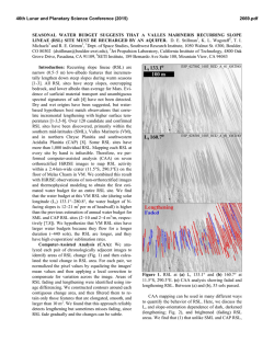
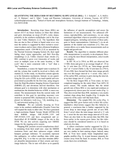
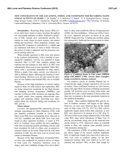
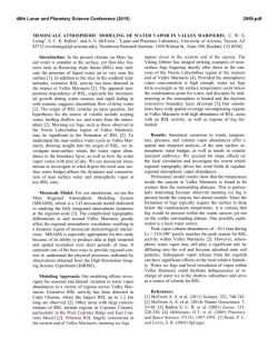
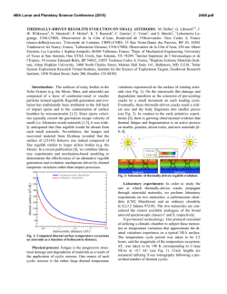
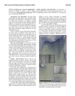
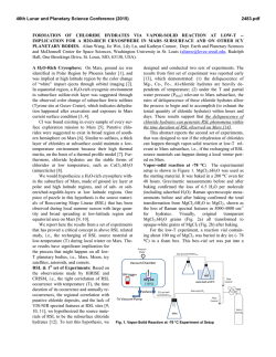
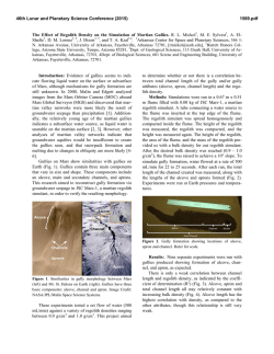
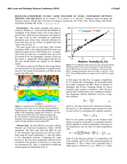
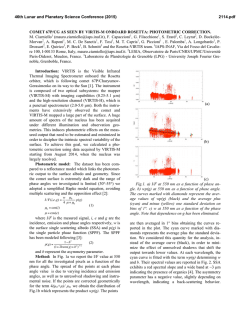
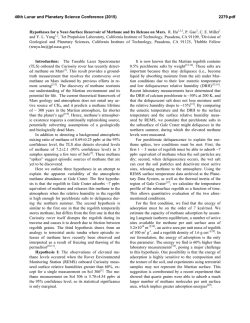
46th Lunar and Planetary Science Conference (2015)
2286.pdf
THE WATER CONTENT OF RECURRING SLOPE LINEAE ON MARS. C. S. Edwards1 & S. Piqueux2;
1
United States Geological Survey, Astrogeology Science Center, Flagstaff, AZ, [email protected]; 2Jet Propulsion
Laboratory, California Institute of Technology, Pasadena, CA.
Introduction
Evidence for ancient flowing water on the surface
of Mars is widespread and varied [1-3], but present day
liquid water may only be transient, briny, and confined
to limited areas where solar insolation and temperatures are maximal [4-6]. In particular, Recurring Slope
Linea (RSL observed on warm Martian slopes (Fig. 1)
are meter-scale seasonally recurring dark flow-like
features [7-9], potentially associated with liquid water.
Other hypotheses for the formation of these features
have been proposed, including dry granular flows and
seasonal oscillations of near-surface adsorbed water
[7].
Numerical models, laboratory work, and Antarctic
analogues corroborate the liquid water-brine hypothesis for these flows [4, 11, 12]. The seasonality of RSL
is also not consistent with recurring granular flows or
absorption of atmospheric vapor [7, 9], as RSL are
most active during low atmospheric water vapor seasons [13]. For these reasons, the liquid water-brine
hypothesis is favored by the community and is adopted
as a testable formation mechanism in this study. So far,
the direct spectral signature of water (liquid or solid)
has not been identified in RSL, supporting the hypothesis that these features involve small amounts of liquid
[7, 14, 15]. Placing quantitative constraints on the
water content of RSL would greatly help understanding their formation mechanism, but is difficult and todate has only been limited to morphological observations and models[5].
Methods
In this study, we quantify the amount of water associated with RSL using nighttime surface temperature
data from THEMIS analyzed in conjunction with
(near)surface heat transfer numerical modeling [16]
incorporating predicted thermophysical properties of
wet regolith under Martian pressure/temperature conditions. Seasonal temperature variations between RSLdense terrains compared to nearby dry regolith is used
as the pixel-to-pixel calibration of THEMIS is <~1K
(NE∆T @ 180K) and minimized the effects of a variable an difficult-to-remove atmosphere. This temperature difference between dry regolith and RSL dense
terrains is shown in Fig. 2 in the form of a surface
temperature difference, hereafter ∆T.
For this work, we focus on constraining the water
content of RSL in a well characterized RSL-bearing
region in Valles Marineris on the walls of an unnamed
crater [9], where extensive daytime and nighttime
THEMIS, HiRISE, and Context Imager (CTX) coverage already exists. In addition to having been previously characterized in detail [9], this area is suitable for
further thermal analysis with THEMIS as it displays:
1) limited bedrock outcrops at the origination of the
RSL, avoiding anisothermal behaviors with the finer
slope materials ; 2) high density of RSL terrain versus
dry slope material (up to 88%, typically >40% of a
THEMIS pixel) maximizing wet regolith signal versus
nearby dry material; 3) an extensive areal region, encompassing multiple THEMIS 100 meter pixels (Fig.
1); and 4) multi year seasonal THEMIS coverage (Fig.
2, data from individual years are not explicitly required
as RSL occur in the same general regions year to year
[7]). THEMIS surface temperature observations of the
crater in VallesThe
Marineris span the full Martian Year,
including times when RSL are actively growing, during minor growth, fading, or not active (Fig. 2).
Fig. 1. Observations of the RSL containing crater in Valles Marineris centered at ~290.3˚E, 11.5˚S[9]. A) Colorized MOLA elevation[10] overlain on the THEMIS daytime temperature global mosaic B) CTX image C-E) HiRISE observations spanning Ls ~133
to 235 showing the generalized RSL progression in the region (Fig. 2) and locations of THEMIS observations
46th Lunar and Planetary Science Conference (2015)
2286.pdf
RSL vs. Dry Regolith Seasonal THEMIS Nighttime Temperatures
0
300
3
300x300m Average ∆T
Mars Year 32
Mars Year 31
Mars Year 30
Mars Year 29
Mars Year 28
Mars Year 27
Mars Year 26
100m/pixel ∆T± 0.5K
Dry Regolith Model
1
1-σ
in
+ a strum
vg
err ent
or
0
No high quality
nighttime data
coverage > Ls 298˚
-1
Thermal Inertia Increase (%)
∆ Temperature (K)
2
250
Amount of Water (wt %)
1.5
2
2.5
3
3.5
4
A)
50 J m-2 K-1 s-1/2
100 J m-2 K-1 s-1/2
150 J m-2 K-1 s-1/2
200 J m-2 K-1 s-1/2
250 J m-2 K-1 s-1/2
200
150
100
0
1
Local Time
0315-0330
0345-0400
0400-0415
0415-0430
0430-0445
Generalised RSL
Activity from HiRISE
0445-0500
0500-0515
0530-0545
Avg. Difference ± 1σ
0
-0.3 ± 0.4
0
50
100
200
150
Solar Longitude
(˚Ls for all Mars years)
250
Active
Minor Growth
Fading/
No Detection
300
350
Fig. 2 ∆T vs Ls for all THEMIS nighttime band 4 & 9 integrated temperature images covering the crater in Fig. 1.
(Top) Data from all Mars years are shown as different color
points on the black line. Average data are from two 300x300m
regions on the most active RSL location (Fig. 1, white box)
and nearby dry regolith location (Fig. 1, black box). All temperatures are referenced to the dry regolith, including the
individual, 100m/pixel data. The estimated error in the measurement accounting for the 1-σ standard deviation of the
average 3x3 pixel (~300x300m) box and ~0.5K relative uncertainty of THEMIS measurements (orange). The grey
dashed line is a model temperature curve simulating the dry
regolith temperature variations expected from subtracting the
model temperatures of different azimuths on and off the RSL
locations in Fig. 1. This model accounts for variations in
individual image local time, Ls, on/off RSL albedo (0.168;
0.152 respectively), slope and azimuth of each locations (30˚,
305; 30˚, 290˚ respectively), and THEMIS derived dry regolith inertia (230 J K-1 m-2 s-1/2). (Bottom) The difference between the THEMIS measured and dry-regolith model ∆T is
shown, Local time is shown as grayscale points.
Results and Implications
Water (solid/liquid) has a significant effect on the
thermophysical properties of particulate regolith by
increasing the bulk thermal conductivity, specific heat,
and density, resulting in high thermal inertias and
unique diurnal/seasonal temperature signatures. For
this reason, surface temperatures and their seasonal
variations are sensitive to small amounts of pore-filling
water and represent an ideal measurable quantity to
characterize the water content of RSL.
Over multiple years of monitoring with THEMIS
nighttime data, no distinct thermal signal between wet
(i.e. RSL bearing) and dry (i.e. nearby non RSL bearing) terrains is detected (Fig. 2) within the instrument
detection limits (~1K), regardless of season. Numerical
modeling of wet regolith under martian conditions of
temperature and pressure indicates that terrains containing at least ~50 kg of water per m3 of regolith, or
roughly 0.5-3 wt% (depending on wet layer thickness)
should have such a distinct thermal behavior. We conclude that the RSL-bearing terrains must be mm thin
and contain ~50 kg of water per m3 of regolith, or
roughly 3 wt% at most, or have any thickness but contain <6 kg of water per m3 of regolith.
0.10
100
B)
0.09
90
Wet Layer Thickness (m)
% RSL in a THEMIS pixel
Measured-Modelled
Temperature Difference (K)
1
50
-2
-1
0.5
0.08
80
0.07
70
0.06
60
0.05
50
0.04
40
1K Detection Threshold
0.03
30
0.02
20
0.01
10
0
0
0
10
20
30
40
50
Amount of Water (kg per m3 of soil)
0
60
70
5
10
15
Temperature Increase (K)
Fig. 3. A) Thermal inertia increase (in %) versus amount of
interstitial liquid water for five particle sizes consisting of
20 µm, 40µm, 100 µm, 240 µm, and 400 µm (50, 100, 150,
200, and 250 J K-1 m-2 s-1/2, respectively). B) Modeled
nighttime (0449 local time, 174 Ls) ∆T as a function of the
wet layer thickness (Y axis) and amount of water (X axis).
This result is consistent with the morphological
modeling of [5] and is also consistent with expected
seasonal albedo changes from wetting followed by
freezing of small amounts of pore filling water [14].
The lack of a visible/near-infrared spectral signature
attributable to water, as a fluid, solid, or in mineral
structures [15], is also consistent with our results, as
such low wt %s would likely have a small spectral
contribution. The lack of spectral detection of cementing salts (expected to build up over time), coupled with
the local thermal inertia values (i.e. ~230 J m-2 K-1 s-1/2,
only consistent with fine uncemented regolith) and
high peak daytime temperatures (well above 273K),
lead us to conclude the RSL in this area are associated
with fresh water [6]. Irrespective of salinity, these
flows experience diurnal/seasonal freeze/thaw and/or
complete evaporation/sublimation cycles that may hinder their habitability.
References
[1] M. H. Carr, G. D. Clow, (1981) Icarus 48, 91. [2] P. R.
Christensen, (2003) Nature 422, 45. [3] J.-P. Bibring et al.,
(2006) Science 312, 400. [4] V. F. Chevrier, E. G. RiveraValentin, (2012) Geophys Res Lett 39, L21202. [5] R. E.
Grimm et al., (2014) Icarus 233, 316. [7] A. S. McEwen et
al., (2011) Science 333, 740. [8] L. Ojha et al., (2014)
Icarus 231, 365. [9] A. S. McEwen et al., (2014) N. Geo. 7,
53. [10] D. E. Smith et al., (2001) JGR 106, 23689. [11] A.
Wang et al., (2013) LPSC 1719, 2606. [12] J. Dickson, J.
Head, LPSC, 2012. [13] M. D. Smith, (2002) JGR 197,
5115. [14] H. Zhang, K. J. Voss, (2006) Applied Optics 45,
8753. [15] L. Ojha et al., (2013) GRL 40, 2013GL057893.
[16] H. H. Kieffer, (2013) JGR 118, 451.

© Copyright 2026