
Opportunity In Situ Geologic Context of Aqueous - USRA
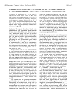
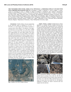
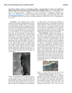
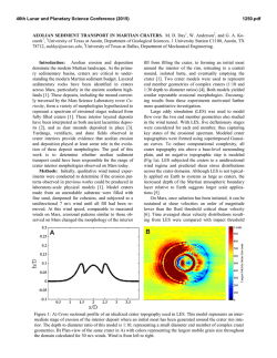
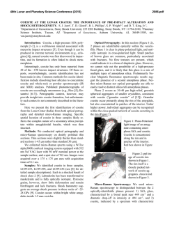
46th Lunar and Planetary Science Conference (2015)
2209.pdf
OPPORTUNITY IN SITU GEOLOGIC CONTEXT OF AQUEOUS ALTERATION ALONG OFFSETS IN
THE RIM OF ENDEAVOUR CRATER. L. S. Crumpler1, R. E. Arvidson2, W. H. Farrand3, M. P. Golombek4, J.
A. Grant5, D. W. Ming6, D. W. Mittlefehldt6, T. J. Parker4, 1New Mexico Museum of Natural History & Science,
1801 Mountain Rd NW Albuquerque, NM, 87104, USA, [email protected], 2Washington University in St
Louis, St. Louis, MO, USA, 3Space Science Institute, Boulder, CO, USA, 4Jet Propulsion Laboratory, Caltech, 4800
Oak Grove Drive, Pasadena, CA 91109, 5Smithsonian Institution, NASM CEPS, 6th at Independence SW, Washington, DC, 20560, 6NASA Johnson Space Center, Houston, TX, United States, 77058, USA
Introduction: Mars Exploration Rover Opportunity
traversed 7.9 km and 27 degrees of arc along the rim of
the 22 km-diameter Noachian "Endeavour" impact crater since its arrival 1200 sols ago. Areas of aqueous and
low-grade thermal alteration, and changes in structure,
attitude, and macroscopic texture of outcrops are notable across several discontinuities between segments of
the crater rim. The discontinuities and other post-impact
joints and fractures coincide with sites of apparent deep
fluid circulation processes responsible for thermal and
chemical alteration of local outcrops.
In Situ Geology of Rim: Opportunity determined the
elemental, spectral, and petrographic character of distinctive outcrop lithologies along the crater rim [cf. 1, 2,
3, 4]. The petrologic results, contacts, attitudes of bedding, and structures have been mapped along a swath
determined by the limit of Navcam detection, empirically defined at ~20 m distance from the rover [4]. Outcrops examined along the rim crest and upper slopes at
Cape York and south at Murray Ridge consist of impact
breccias ("Shoemaker formation") from >> 5 m thick
overlying smectite bearing [1] fine-grained pre-impact
materials ("Matijevic formation") (>>3 m thick), both
laced with thin (1-2 mm) CaSO4 veins [1]. An overlying
unit ("Grasberg formation") (<1m thick) drapes in unconformable contact over the deeply eroded Shoemaker
breccias. The eroded and weathered upper surface of the
moderately dipping (~10°) Grasberg fm is in turn overlain by the sulfate-rich sands of the "Burns formation"
(>100m thick) constituting most of the surface of Meridiani Planum and partially burying and filling Endeavour crater.
Mapping has continued south of Cape York along the
western margin of Endeavour crater (Fig. 1). A consistent stratigraphy determined from correlation of results
from site to site, along with determination of attitude of
contacts [4], outlines the geologic history and sequence
of alteration events. The recognition of an azimuthally
segmented structural fabric of the rim correlates with
distinct sites of identified petrologic differences and
intensities of aqueous alteration.
Segmented Structural Regimes: Segmentation of the
crater rim occurs as azimuthal discontinuities in relief
Figure 1. A. In situ mapping along Opportunity's traverse.
Dashed lines denote boundaries between left and rightstepping rim segments, across which structure, outcrop
characteristics, and elemental abundances differ. B-F. Sites
of in situ measurements discussed in the text (white dots).
46th Lunar and Planetary Science Conference (2015)
and patterns of surface roughness. In situ detection of
differences in geologic character and disparities in structural grain across these segments are apparent along the
rim from Murray Ridge and southward to Cape Tribulation. Alteration is pervasive at outcrops throughout the
rim, but it is at or near the boundaries between segments
where the most intense alteration [5] has been observed.
General Rim Structure: The crater rim consists of
right and left-stepping segments and low and narrow
segments that are sinuous. The western slopes are planed
along uniform grades of ~10° while bedding/laminations
of outcrops exceed the slope angle (~10°). But planar
features east of the rim consistently dip shallowly eastward, as do outcrops observed along-strike in the vicinity of segment offsets. The origin of a uniform sloping
pediment-like planation of the western slopes across the
dipping beds remains unclear.
Solander Point (Fig 1b): The geologic sequence here
is consistent with that noted 1500 m to the north at Cape
York in which the Burns fm is in unconformable contact
with the dipping weathered carapace of the Grasberg fm.
Structural contours on the contact between the BurnsGrasberg fms and the Noachian rim breccias ascends
from east to west around Solander Point implying a thinning of the late sulfate sands inboard of the crater rim.
Laminations or layering of the Shoemaker fm breccias
dip westward (~20°) along a ridgeline ("Murray Ridge")
that continues south 800 m.
Cook Haven (Fig 1c): Observations during the 5th
winter were conducted at "Cook Haven", where Murray
Ridge steps left and there is a change in relief, outcrop
habit, and plunge of the ridge crest. Fractures in the
plains to the west are coincident with the strike (N69W)
of the discontinuity in ridge characteristics, denoting a
possible relationship with a deep-seated fracture. Unusual exposures in the outcrop here have oxidized coatings enriched in Mn deposited on sulfates suggesting
enhanced low-grade oxidizing, and possible thermal,
aqueous deposition [5, 8].
"Al-OH Region" (Fig 1d): 400m south of Cook Haven Murray ridge steps left. This segment is notable in
that CRISM spectra detected the presence of aluminous
smectite [6]. Also, near the crest and on the western
slope near the step "Pillinger Point", CaSO4 veins are
more prominent in rim outcrops than elsewhere. Both
observations indicate that in addition to acting as zones
of enhanced alteration, the discontinuities are also
boundaries on segments with different prevailing alteration histories.
Wdowiak Ridge (Fig 1e): Dark, fine-grained rocks
occur at two locations, 80 m south of Cook Haven and at
Wdowiak Ridge, an unusual ridge aligned with the north
margin of the right-stepping Cape Tribulation rim segment. The rocks capping Wdowiak Ridge are a dense 20
m x 200 m mass several meters thick of irregularly fractured dark blocks perched several meters above the sur-
2209.pdf
roundings and represent yet another manifestation of
segment boundaries. The dark rocks are compositionally
distinct from the Shoemaker formation breccias of the
crater rim [6]. Given the deep erosion of the crater rim
[7] and similar rocks elsewhere along the crest of the
crater rim, inversion of topography representing former
trough aligned along the segment boundary appears
likely. Either the dark rocks were emplaced as massive
deposits (impact melt?) or fragmented, mobilized, and
collected in the trough.
"The Fracture" (Fig 1f): Outcrops are sparse on the
tilted planar slopes of the ridge leading up to Cape
Tribulation summit. Tangential and radial fractures occur here not seen elsewhere in Noachian outcrops along
the rim. Opportunity examined outcrops exposed in a radially oriented example, a simple 2-3 m wide graben,
"The Fracture". Higher Cl and S concentrations in these
outcrops highlight the potential for any vertical discontinuity to enhance localized fluid flow.
Interpretation: Discontinuities in the rim are consistent with development of transverse faults as the upward
and radial compression of the upper crust during crater
formation is accommodated by a series of discontinuous
oblique thrust faults along discreet blocks. The relative
motion between blocks would require accommodation
by vertical dip, oblique slip scissor faults or lateral ramp
structures. Inspection of MRO/HiRISE image data along
the rim of Santa Fe crater, in Chryse Planitia (19.5°N
48.0°W), a similar size (21 km), but much younger
(Amazonian) complex crater, suggests that the fault
zones may re-activate as oblique slip zones accommodating inboard extension within crustal blocks during
post-impact modification. Mylonization and fault-line
brecciation along the bounding deep crustal faults serve
as major vertical discontinuities and high permeability
pathways along the rim. Both post-impact hydrothermal
circulation [8] and regional groundwater much later
would preferentially follow these zones during the processes associated with subsequent aqueous alteration.
Conclusions: Rim segmentation by transverse faults
enhanced aqueous chemical alteration in specific locations along the rim of Endeavour crater. Fracture controlled alteration may be another origin for hydrated
minerals detected along the rims of many Noachian
craters [9]. Combined with the apparent exposure of preimpact lithologies, as noted in the rim at Endeavour [4],
impact crater rims also favor retention of physical and
chemical evidence of past complex aqueous environments and chemistries.
References Cited: [1] Squyres et al, (2012). Science 336,
570; [2] Arvidson et al., (2013). Science; [3] Ferrand et al.,
(2014), JGR, in press; [4] Crumpler et al., (2014), JGR, in revision; [5] Arvidson et al., (2015), this conference; [6] Mittlefehldt et al., (2015), this volume [7] Grant et al., (2015), this
volume; [8] Newsom et al., (1986), JGR, 1981, [8] Ming et al,
(2015), this conference; [9] Fairen et al, (2010). Proc.Nat'l
A.S., 107. 12095-12100.
© Copyright 2026