
Geospatial Classification of Transverse Aeolian Ridges on Mars
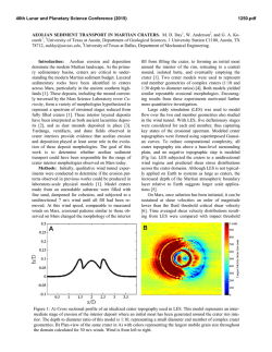
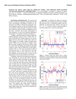
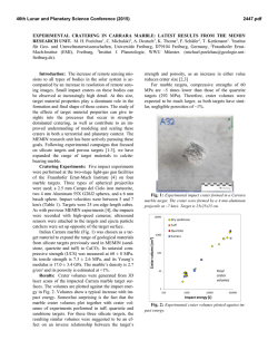
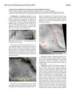
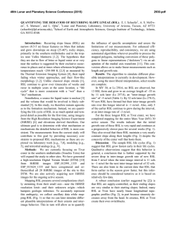
46th Lunar and Planetary Science Conference (2015)
1137.pdf
GEOSPATIAL CLASSIFICATION OF TRANSVERSE AEOLIAN RIDGES ON MARS. E. K. Ebinger1 and
J. R. Zimbelman2, 1Brown University Department of Geological Sciences, Providence, RI 20912,
[email protected], 2CEPS/NASM MRC 315, Smithsonian Institution, Washington, DC 20013-7012.
Introduction: Small aeolian bedforms, known as
Transverse Aeolian Ridges (TARs) are widespread on
the martain surface. It is unknown whether the features
are large ripples or small dunes [1,2], but insight can
be gained from their distribution on Mars. We have
geospatially mapped TARs within two pole-to-pole
swaths and hypothesize that TARs are controlled by
local geology, elevation, and latitude.
Analysis of HiRISE images at two longitudes indicates that TARs are not homogenously distributed on
Mars. Instead, they are concentrated in low latitudes
with almost none poleward of 45°N and 50°S. In addition, TARs are more common in topographic lows.
They are found in craters, troughs, and valleys – especially in Valles Marineris and Kasei Valles – but their
presence is diminished in the Tharsis region.
Methodology: Two pole-to-pole swaths – 290°E300°E and 240°E-250°E – were chosen for examination because they contain some of the highest and lowest elevations on Mars. Nearly 1000 HiRISE images
were examined in HiView and the local TAR coverage
per image was estimated and recorded. TARs were
identified and classified using the classification
scheme of Balme et al. (2008), which describes TARs
by morphology (simple, networked, forked, sinuous,
barchan-like) and topographical influence (independent, influenced, controlled, confined). All examined
images were then located according to their center latitude and longitude (Figure 1).
Findings: The mean areal TAR coverage for the
290°E-300°E swath is 8% (4% in the Northern Hemisphere and 12% in the Southern Hemisphere) and 42%
of the surveyed images contained at least 5% coverage
by TARs, while 25% contained no TARs at all.
The mean areal TAR coverage for the 240°E250°E swath is 1% (0.6% in the Northern Hemisphere
and 1.8% in the Southern Hemisphere). Of the surveyed images, 6% contained at least 5% coverage by
TARs, while 70% contained no TARs at all.
Thus, the mean areal TAR coverage for both
swaths is 5%, and no TARs were found poleward of
64N nor 59S. Based on these data, we propose that
TARs are controlled by local geology, which is influenced by elevation and latitude.
Local geology. The composition and formation of
TARs is still unclear, mostly due to lack of in situ
measurements. However, potential terrestrial analogs
such as small transverse dunes and large granule ripples give insight into the structure of TARs [1, 3]. We
hypothesize that TARs consist of coarse-grained sediment that traps sand and silt, similar to the gravelmantled megaripples of the Argentinian Puna [4].
The sediment source is likely locally derived [1,2]
from weathering, wind abrasion, and mass wasting.
Thus, regions with steep slopes and local exposures of
layered bedrock have more extensive TAR fields due
to increased local sediment supply. This sediment is
trapped in topographic lows such as craters, valleys,
channels, and troughs. It is in these controlled or confined locations where TARs are most commonly found
(Figure 2a, 2b). In addition, regions with less sand are
assumed to have fewer TARs, which is evident when
looking at the dusty surface of Pavonis Mons. Under
low local pressures, dust that settles from the martian
atmosphere is trapped on the Tharsis Montes, accumulating thick layers of dust [5]. The timeframe from
which TARs form is unclear, but if TARs formed in
Tharsis long ago they may have since been buried in
dust. And if TARs are currently active, there may not
be enough sand at high altitudes to sustain TARs – the
low pressures are unfavorable for saltation and creep
of the coarse-grained material assumed to comprise
TARs [5] (Figure 2c).
Figure 1: Distribution of HiRISE images surveyed with percent
TAR coverage indicated by size of circle (larger = greater coverage) with MOLA background and swaths outlined in white.
46th Lunar and Planetary Science Conference (2015)
Elevation. Therefore, one dominant control on the
formation of TARs is local elevation. TARs were not
found on steep slopes or mountains but instead almost
exclusively within topographic lows. Elevation is more
than just a local control, however. As seen from the
distribution of TARs (Figure 1) there is a greater abundance at lower elevations across the planet. TAR fields
within Tharsis are sparce and mostly isolated, while
TARs are plentiful within Valles Marineris and Kasei
Valles (Figure 3). This disjunction is likely a result of
differences in local geology and air pressure – the lows
of Valles Marineris and Kasei Valles are favorable for
accumulation of sediment that sources TARs, while the
high dusty surfaces of Tharsis do not favor the formation of TARs.
Latitude. Another control on TAR formation is
latitude. TARs are not ubiquitous, and are actually
heavily concentrated at low latitudes. Excluding a few
outliers, TAR concentrations are restricted to between
45N and 50S. TARs are almost absent within the
Northern Plains, and despite their presence within
many craters there appear to be almost none poleward
of 50S – however, it should be noted that TARs are 3x
more prevalent in the Southern Hemisphere than in the
North, likely due to the greater number of large impact
craters. The lack of TARs at high latitudes is possibly
related to the presence of mantling terrain, which could
be preventing aeolian transportation of the materials
that comprise TARs and/or burying TARs (Figure 2d)
[2]. Thus, although the elevation of the Northern
Plains is lower than most of the martian terrain, it is
too high in latitude to favor TARs.
1137.pdf
Future studies should examine pole-to-pole swaths
in other regions of Mars to test these conclusions, notbaly the Nilosyrtis Highlands. In addition, sampling of
TAR-like features by the Curiosity rover or future rover expeditions are needed to further understand the
composition and formation of TARs.
References: [1] Balme M.R. et al. (2008) Geomorphology 101, 703-720. [2] Berman D.C. et al. (2011) Icarus 213,
116-130. [3] Zimbelman J.R. (2010) Geomorphology 121,
22-29. [4] de Silva S.L. et al. (2013) GSA Bulletin 125, 19121929. [5] Bridges N.T. et al. (2010) Icarus 205, 165-182.
a
100 m
ESP_028305_1210
ESP_014391_2045
c
d
50 m
ESP_016846_1710
100 m
ESP_035265_1675
Figure 2: TARs form mostly in depressions near steep slopes
and layered bedrock, as seen in a) Kasei Valles and b) Coprates Chasma. However, c) on Tharsis ripples form within
craters rather than TARs, and d) in the Southern Highlands
mantled terrain and ground ice hinder TAR formation.
b
a
% TAR coverage:
0-4 = blue
5-25 = green
26-50 = yellow
51-100 = red
b
50 m
% TAR coverage:
0-4 = blue
5-25 = green
26-50 = yellow
51-100 = red
Figure 3: Distribution of HiRISE images included in study from a portion of a)Valles Marineris and b)Pavonis Mons, with backgrounds from
Google Mars. Percent areal TAR coverage designated by color of image outline rectangle.
© Copyright 2026