
Slides - Fosdem
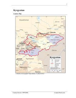
QGIS Tool for Landslide Hazard Assessment
Darya Golovko,
Sigrid Roessner, Robert Behling and Hans-Ulrich Wetzel
GFZ Potsdam – German Research Centre for Geosciences
Section 1.4 - Remote Sensing
Telegrafenberg 14473 Potsdam
email: [email protected]
QGIS Tool for Landslide Hazard Assessment
Study Area – Southern Kyrgyzstan
•Ongoing active mountain
building in Central Asia
•Frequent occurrence of
extreme natural processes
•Landslides one of the major
hazards in Kyrgyzstan
•Highest concentration at
eastern rim of Fergana basin
•Study area: 100x100km²
Kyrgyzstan
Study Area
Yellow points represent landslides after Yerokhin (1999)
QGIS Tool for Landslide Hazard Assessment
Landslide Situation in Southern Kyrgyzstan
Rapid displacement of quaternary loess within
15 minutes period in March 1994 (50 victims)
Displacement of clay-rich tertiary sediments during
period of several days in June 1998
• Regular monitoring by Ministry of Emergency Situations until 1991
• Drastic decrease in financing after 1991 + high process intensity in 1994 (97 casualties)
• Currently: unsystematic investigations by the Ministry + occasional systematic investigations by
other organizations
• Intensive year can be expected in near future
QGIS Tool for Landslide Hazard Assessment
Landslide Hazard Assessment
Predisposing factors
- Lithology
- Structural and
neotectonic setting
- Relief
- Human interference
Landslide inventory
Hazard assessment
Spatial
probability
after Guzzetti et al. 2005
Triggering factors
-Precipitation/ seasonal
snowmelt and related
infiltration
- Seismic activity/
earthquakes
Temporal
probability
Magnitude
probability
QGIS Tool for Landslide Hazard Assessment
QGIS Plugin Overview
•
QGIS plugin offering customized data queries
and spatial analysis tools
•
Open-source software in order to reduce costs
and meet requirements of multiple end users
•
Possibility of data updates in a single location
•
Incorporation of data on landslide predisposing
and triggering factors
QGIS plugin dropdown menus ►
QGIS Tool for Landslide Hazard Assessment
Data Queries
•
Typical workflow: selecting landslide / factor data for a certain time period and
assigning them to mapping units for further analysis
Menus for querying
landslide and
earthquake data
QGIS Tool for Landslide Hazard Assessment
Data Queries
•
Typical workflow: selecting landslide / factor data for a certain time period and
assigning them to mapping units for further analysis
Slope failures (red) and
earthquakes (blue) that
occurred in 1990 - 1999
QGIS Tool for Landslide Hazard Assessment
Data Queries
•
Typical workflow: selecting landslide / factor data for a certain time period and
assigning them to mapping units for further analysis
Landslides have been
assigned to mapping units;
the number of landslides
has been calculated for
each mapping unit
QGIS Tool for Landslide Hazard Assessment
Tools for Spatial Analysis
Points belonging to landslide
main scarps and mapping
units showing the number of
landslides in them
►
QGIS Tool for Landslide Hazard Assessment
Tools for Spatial Analysis
Calculation of earthquake influence using empirical formulas for Arias intensity
QGIS Tool for Landslide Hazard Assessment


© Copyright 2026