
30/01/2015 Quarterly Activities and Cashflow Report
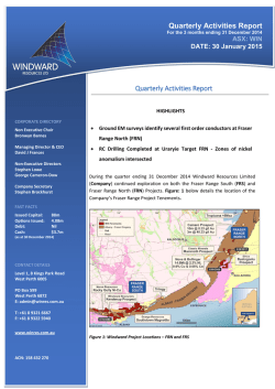
Quarterly Activities Report
For the 3 months ending 31 December 2014
ASX: WIN
DATE: 30 January 2015
Quarterly Activities Report
HIGHLIGHTS
CORPORATE DIRECTORY
Non Executive Chair
Bronwyn Barnes
Managing Director & CEO
David J Frances
Non-Executive Directors
Stephen Lowe
George Cameron-Dow
Company Secretary
Stephen Brockhurst
•
Ground EM surveys identify several first order conductors at Fraser
Range North (FRN)
•
RC Drilling Completed at Uraryie Target FRN - Zones of nickel
anomalism intersected
During the quarter ending 31 December 2014 Windward Resources Limited
(Company) continued exploration on both the Fraser Range South (FRS) and
Fraser Range North (FRN) Projects. Figure: 1 below details the location of the
Company’s Fraser Range Project Tenements.
FAST FACTS
Issued Capital:
Options Issued:
Debt:
Cash:
88m
4.08m
Nil
$3.7m
(as at 30 December 2014)
CONTACT DETAILS
Level 1, 8 Kings Park Road
West Perth 6005
PO Box 599
West Perth 6872
E: [email protected]
T: +61 8 9321 6667
F: +61 8 9322 5940
www.winres.com.au
ACN: 158 432 270
Figure 1: Windward Project Locations – FRN and FRS
FRASER RANGE NORTH PROJECT (FRN)
The FRN Project comprises 8 tenements covering a total of 1,933 km2, located in the Fraser Range of Western
Australia. Two tenement applications (70 km2) are pending. The tenements extend approximately 180 km from
Zanthus in the north to Fraser Range Station in the south. The tenements are located in the Albany – Fraser Orogen
consisting of a number of paleo-Proterozoic high grade and structural domains that parallel the NE trending margin
of the Yilgarn Craton.
Exploration activities at the FRN project continued during the quarter with a number of programs being completed.
These included ground EM survey’s (MLEM & FLEM), and RC drilling at 2 prospect areas.
GROUND EM SURVEYS
With the completion of a large airborne electromagnetic survey (HeliTEM) at the FRN Project during the last quarter
a number of targets were further tested using ground EM techniques to provide better definition and validation of
the airborne results. These ground EM surveys are on-going.
Turcaud Prospect (FRN)
At the Turcaud prospect (Figure: 2) ground EM surveys have confirmed the presence of three high-conductivity
first-order conductors. The Turcaud prospect was initially identified as a structural target and was subsequently
covered by surface geochemical sampling. Sandy soils returned subdued but contourable and coincident nickel
(>40ppm), copper (>23ppm), and cobalt (>10ppm) anomalism which overlie first-order conductors identified from
the HeliTEM (AEM) survey. Ground EM has identified three high-conductivity targets (up to 3,300 siemens)
associated with the AEM conductors at Turcaud (ASX: 15 December 2014). An additional high priority conductor
of 5,500S was discovered whilst completing further loops at Turcaud.
A ground EM survey was completed at the WinEye prospect, where a first order AEM conductor was identified,
has shown this target likely represents two broader and lower conductivity targets potentially related to lithology.
RC DRILLING
Uraryie Prospect (FRN)
Reverse circulation (RC) drilling was completed at the Uraryie prospect in December 2014 – Figure: 3. A total of 12
holes were completed for 804 metres – detailed in Table 1 below. The drilling was targeted at testing both the
magnetic and non-magnetic areas within this prospect particularly where anomalous rare earth elements (REE’s)
had been returned from previous drilling (ASX: 15 December 2014). Multi-element assays have only been recently
received from this drilling programme. They show anomalous nickel assays up to 0.55% Ni from the western region
(magnetic zones) of this target. Drill hole 14URRC001 has returned two zones of nickel concentration from
composite (4 metre) sampling with 12 metres averaging 3,975ppm Ni (max of 5,550ppm Ni) from 28m to 48m. A
second zone of nickel enrichment of 26 metres @ 2,352ppm Ni was returned from 88m to 144m (EOH). All
significant results from this drilling are shown in Table 2. The rare earth elements returned only weakly anomalous
results which are generally confined to a narrow horizon directly below (or within) a palaeochannel which was
intersected in most drill holes.
Table 1: Hole details for RC drilling at the Uraryie Prospect
Hole_ID
Easting
Northing
14URRC001
538482
6547365
14URRC002
538593
6547188
14URRC003
538667
6547125
14URRC004
538711
6547044
14URRC005
538792
6547203
14URRC006
538824
6547450
14URRC007
538745
6547542
14URRC008
538688
6547622
14URRC009
538938
6547770
14URRC010
539097
6547764
14URRC011
539392
6547636
539362
6547511
Azimuth
RL
Dip
Total_Depth (m)
E.O.H _Lithology
360
240
-90
114
gabbro and mafic granulite
360
240
-90
54
gabbro and mafic granulite
360
240
-90
54
undiff Intermediate
360
240
-90
60
mafic granulite
360
240
-90
84
granodiorite
360
240
-90
60
granodiorite
360
240
-90
54
gabbro and mafic granulite
360
240
-90
54
mafic granulite
360
240
-90
78
mafic schist
360
240
-90
66
mafic schist
360
240
-90
60
mafic schist
240
-90
66
palaeochannel
14URRC012
360
* All coordinates are MGA94 Zone 51 with a nominal 240mAHD RL
Table 2: Significant Nickel and Copper assays from RC drilling at Uraryie Prospect
Hole ID
From (m)
To (m)
Interval (m)
Ni (ppm)
Cu (ppm)
Comments
14URRC001
28
48
12
3,975
nsa
5,550 ppm Ni max
14URRC001
88
114
26
2,352
nsa
>2,000 ppm Ni at EOH
14URRC002
72
88
16
480
274
14URRC002
44
48
4
2000
nsa
14URRC003
32
36
4
1955
nsa
14URRC004
44
52
8
2020
nsa
14URRC008
32
36
4
2190
nsa
2,130 ppm Ni max
Turcaud Prospect (FRN)
RC drilling has been completed at the Turcaud prospect during the quarter and work is ongoing. Two RC drill holes were
completed in December for a total of 485m. Drillhole details are outlined below in Table 3, assays are due to be received
in January. Drill holes 14TCRC001 and 14TCRC002 were drilled to test conductor targets of 3,300S and 5,500S respectively.
14TCRC001 did not reach target depth due to adverse drilling conditions and downhole EM (DHEM) will be conducted.
Hole14TCRC002 was completed to test a high-order (5,500S) conductor and was drilled to 275m intersecting a thick
package of sulphidic (pyrrhotite), and intermittently graphitic, mafic schist and gneiss. Minor pyrite veining and
chalcopyrite was observed at the interpreted model intersection depth. The material intersected in the hole appears not
to explain the original FLEM conductor so a DHEM survey will be undertaken.
Table 3: RC Hole Coordinates – Turcaud prospect
Tenement
Easting
(MGA94,
Z51)
Northing
(MGA94,
Z51)
14TCRC001
E69/2989
532715
6469835
259
14TCRC002
E69/2989
532667
6469799
259
Hole No
RL
(Nominal)
EOH
Depth
(m)
Dip
(degrees)
Azimuth
(magnetic)
210
-70
125
275
-60
280
FRASER RANGE SOUTH PROJECT (FRS)
The FRS Project comprises 14 tenements covering a total of 5,615 km2, located in the Great Southern and South
West of Western Australia. The project tenements extend from Lake Muir in the west to Jerramungup in the east,
a distance of approximately 250 km. The project tenements cover the western and southern extensions of the
Albany-Fraser Orogen and the South West Yilgarn Craton.
Work on the FRS project during the December quarter was confined to selective outcrop sampling (where
available) in close proximity to identified base metal targets. From this sampling it has been concluded that the
defined targets from the regional roadside sampling programs are valid and that further follow up exploration is
required. No further work is planned for the Kendenup prospect at this stage. The total first-pass roadside
geochemical coverage at the FRS project is shown in Figure: 4.
Figure: 4 - FRS project tenements showing roadside sampling coverage.
EXPLORATION PLANS – CALENDAR YEAR Q1 - 2015
The Company’s exploration programme for CY-Q1 2015 includes the following;
•
•
•
•
•
•
Continuation of ground EM and DHEM surveys (FRN)
Complete further drill testing of conductors identified from ground and downhole EM surveys (FRN)
Complete additional ground access agreements for future exploration (FRS)
Continuation of surface geochemical programmes, covering a number of target areas(FRN)
Investigate elevated nickel and copper anomalism in the Uraryie intrusive complexes
Aircore drilling to be commenced across a number of geochemical targets (FRN)
As one of the few active Fraser Range explorers Windward continues to systematically explore its large land
package with the aim of making an economically significant discovery.
The Company will make regular updates to shareholders as results become available.
CORPORATE
ASX ANNOUNCEMENTS
During the December Quarter 2014 Windward Resources released the following announcements.
DATE
TITLE
15/12/2014
Turcaud Lights-Up - Fraser Range North
28/11/2014
Change of Director's Interest Notices
28/11/2014
Appendix 3B
21/11/2014
Results of Annual General Meeting
21/11/2014
Annual General Meeting Presentation
13/11/2014
Release from Escrow
31/10/2014
Quarterly Activities and Cashflow Report
CASH POSITION
As at 31 December 2015, the Company had $3.7 million in cash and no debt.
David J Frances
Managing Director & CEO
Competent Persons Statement
The information in this document that relates to exploration results is based upon information compiled by Mr Alan Downie, a full‐time employee of Windward
Resources Limited. Mr Downie is a Member of the Australasian Institute of Mining and Metallurgy (AusIMM) and has sufficient experience which is relevant to the
style of mineralisation and type of deposit under consideration and to the activity which he is undertaking to qualify as a Competent Person as defined in the
December 2012 edition of the “Australasian Code for Reporting of Exploration Results, Mineral Resources and Ore Reserves” (JORC Code). Mr Downie consents to
the inclusion in the report of the matters based upon the information in the form and context in which it appears.
Geophysical information in this report is based on exploration data compiled by Mr Brett Adams who is employed as a Consultant to the Company through the
geophysical consultancy Spinifex-GPX Pty Ltd. Mr Adams is a member of the Australian Society of Exploration Geophysicists and of the Australian Institute of
Geoscientists with sufficient experience of relevance to the styles of mineralisation and the types of deposits under consideration, and activities undertaken, to
qualify as a Competent Person as defined in the 2012 Edition of the Joint Ore reserves Committee (JORC) Australasian Code for Reporting of Exploration Results. Mr
Adams consents to the inclusion in the report of matters based on information in the form and context in which it appears.
- END -
Figure: 2 - FRN – Work Programs completed during the December 2014 Quarter.
Figure 3: Uraryie prospect – RC drillhole locations
Appendix 1: Windward Resources Limited – Tenement Information as Required by Listing Rule 5.3.3
TENEMENT
PROJECT
LOCATION
Change in
Holding (%)
Holding
(%)
TENSTATUS
JOINT VENTURE
PARTNER
E 70/3112
Fraser Range South
Rocky Gully
70%
70%
LIVE
CREASY, MARK GARETH
E 70/3113
Fraser Range South
Frankland
70%
70%
LIVE
CREASY, MARK GARETH
E 70/3114
Fraser Range South
Cranbrook
70%
70%
LIVE
CREASY, MARK GARETH
E 70/3115
Fraser Range South
Borden
70%
70%
LIVE
CREASY, MARK GARETH
E 70/3116
Fraser Range South
Bremer Bay
70%
70%
LIVE
CREASY, MARK GARETH
E 70/3117
Fraser Range South
Jerramungup
70%
70%
LIVE
CREASY, MARK GARETH
E 70/4064
Fraser Range South
South Stirling
70%
70%
LIVE
NBX PTY LTD
E 70/4065
Fraser Range South
Narrikup
70%
70%
LIVE
NBX PTY LTD
E 70/4068
Fraser Range South
Mt Barker
70%
70%
LIVE
NBX PTY LTD
E 70/4083*
Fraser Range South
Gairdner
0%
*0%
LIVE
NBX PTY LTD
E 70/4084
Fraser Range South
Chillinup
70%
70%
LIVE
NBX PTY LTD
E 70/4085*
Fraser Range South
Marnigarup
0%
*0%
LIVE
E 70/4105
Fraser Range South
Nunijup
70%
70%
LIVE
NBX PTY LTD
GREAT SOUTHERN
GOLD PTY LTD
E 70/4495
Fraser Range South
Kendenup West
70%
70%
LIVE
E 69/2989
Fraser Range North
Fraser Range
70%
70%
LIVE
E 28/1711
Fraser Range North
Zanthus
70%
70%
LIVE
E 28/1712
Fraser Range North
Zanthus
70%
70%
LIVE
NBX PTY LTD
PONTON MINERALS PTY
LTD
LAKE RIVERS GOLD PTY
LTD
LAKE RIVERS GOLD PTY
LTD
JOINT VENTURE
Fraser Range Tenement Sale and Joint Venture
Agreement
Fraser Range Tenement Sale and Joint Venture
Agreement
Fraser Range Tenement Sale and Joint Venture
Agreement
Fraser Range Tenement Sale and Joint Venture
Agreement
Fraser Range Tenement Sale and Joint Venture
Agreement
Fraser Range Tenement Sale and Joint Venture
Agreement
Fraser Range Tenement Sale and Joint Venture
Agreement
Fraser Range Tenement Sale and Joint Venture
Agreement
Fraser Range Tenement Sale and Joint Venture
Agreement
Farm In and Joint Venture Agreement
Fraser Range Tenement Sale and Joint Venture
Agreement
Farm In and Joint Venture Agreement
Fraser Range Tenement Sale and Joint Venture
Agreement
Fraser Range Tenement Sale and Joint Venture
Agreement
Fraser Range Tenement Sale and Joint Venture
Agreement
Fraser Range Tenement Sale and Joint Venture
Agreement
Fraser Range Tenement Sale and Joint Venture
Agreement
TENEMENT
PROJECT
LOCATION
Change in
Holding (%)
E 28/1713
Fraser Range North
Fraser Range
70%
70%
LIVE
E 28/1715
Fraser Range North
Fraser Range
70%
70%
LIVE
E 28/2017
Fraser Range North
Fraser Range
70%
70%
LIVE
E 69/2990
Fraser Range North
Fraser Range
70%
70%
LIVE
JOINT VENTURE
PARTNER
LAKE RIVERS GOLD PTY
LTD
LAKE RIVERS GOLD PTY
LTD
PONTON MINERALS PTY
LTD
PONTON MINERALS PTY
LTD
ELA 28/2458
Fraser Range North
Zanthus
0%
0%
APPLICATION
Windward Resources
ELA 28/2459
Fraser Range North
Zanthus
100%
100%
LIVE
Windward Resources
ELA 69/3283
Fraser Range North
Balladonia
0%
0%
APPLICATION
Windward Resources
Note:
Holding
(%)
TENSTATUS
JOINT VENTURE
Fraser Range Tenement Sale and Joint Venture
Agreement
Fraser Range Tenement Sale and Joint Venture
Agreement
Fraser Range Tenement Sale and Joint Venture
Agreement
Fraser Range Tenement Sale and Joint Venture
Agreement
Asterix (*) denotes that Windward Resources have the right to earn up to 70% tenements E70/4083 and E70/4085 by meeting specific
expenditure milestones.
© Copyright 2026