
Quarterly Activities Report Quarterly Activities Report
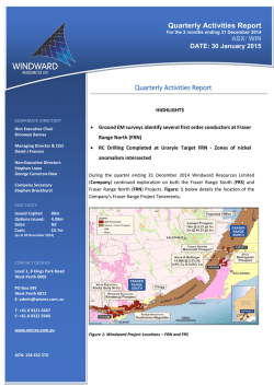
Quarterly Activities Report For the 3 months ending 31 December 2014 ASX: WIN DATE: 30 January 2015 Quarterly Activities Report HIGHLIGHTS CORPORATE DIRECTORY Non Executive Chair Bronwyn Barnes Managing Director & CEO David J Frances Non-Executive Directors Stephen Lowe George Cameron-Dow Company Secretary Stephen Brockhurst • Ground EM surveys identify several first order conductors at Fraser Range North (FRN) • RC Drilling Completed at Uraryie Target FRN - Zones of nickel anomalism intersected During the quarter ending 31 December 2014 Windward Resources Limited (Company) continued exploration on both the Fraser Range South (FRS) and Fraser Range North (FRN) Projects. Figure: 1 below details the location of the Company’s Fraser Range Project Tenements. FAST FACTS Issued Capital: Options Issued: Debt: Cash: 88m 4.08m Nil $3.7m (as at 30 December 2014) CONTACT DETAILS Level 1, 8 Kings Park Road West Perth 6005 PO Box 599 West Perth 6872 E: [email protected] T: +61 8 9321 6667 F: +61 8 9322 5940 www.winres.com.au ACN: 158 432 270 Figure 1: Windward Project Locations – FRN and FRS FRASER RANGE NORTH PROJECT (FRN) The FRN Project comprises 8 tenements covering a total of 1,933 km2, located in the Fraser Range of Western Australia. Two tenement applications (70 km2) are pending. The tenements extend approximately 180 km from Zanthus in the north to Fraser Range Station in the south. The tenements are located in the Albany – Fraser Orogen consisting of a number of paleo-Proterozoic high grade and structural domains that parallel the NE trending margin of the Yilgarn Craton. Exploration activities at the FRN project continued during the quarter with a number of programs being completed. These included ground EM survey’s (MLEM & FLEM), and RC drilling at 2 prospect areas. GROUND EM SURVEYS With the completion of a large airborne electromagnetic survey (HeliTEM) at the FRN Project during the last quarter a number of targets were further tested using ground EM techniques to provide better definition and validation of the airborne results. These ground EM surveys are on-going. Turcaud Prospect (FRN) At the Turcaud prospect (Figure: 2) ground EM surveys have confirmed the presence of three high-conductivity first-order conductors. The Turcaud prospect was initially identified as a structural target and was subsequently covered by surface geochemical sampling. Sandy soils returned subdued but contourable and coincident nickel (>40ppm), copper (>23ppm), and cobalt (>10ppm) anomalism which overlie first-order conductors identified from the HeliTEM (AEM) survey. Ground EM has identified three high-conductivity targets (up to 3,300 siemens) associated with the AEM conductors at Turcaud (ASX: 15 December 2014). An additional high priority conductor of 5,500S was discovered whilst completing further loops at Turcaud. A ground EM survey was completed at the WinEye prospect, where a first order AEM conductor was identified, has shown this target likely represents two broader and lower conductivity targets potentially related to lithology. RC DRILLING Uraryie Prospect (FRN) Reverse circulation (RC) drilling was completed at the Uraryie prospect in December 2014 – Figure: 3. A total of 12 holes were completed for 804 metres – detailed in Table 1 below. The drilling was targeted at testing both the magnetic and non-magnetic areas within this prospect particularly where anomalous rare earth elements (REE’s) had been returned from previous drilling (ASX: 15 December 2014). Multi-element assays have only been recently received from this drilling programme. They show anomalous nickel assays up to 0.55% Ni from the western region (magnetic zones) of this target. Drill hole 14URRC001 has returned two zones of nickel concentration from composite (4 metre) sampling with 12 metres averaging 3,975ppm Ni (max of 5,550ppm Ni) from 28m to 48m. A second zone of nickel enrichment of 26 metres @ 2,352ppm Ni was returned from 88m to 144m (EOH). All significant results from this drilling are shown in Table 2. The rare earth elements returned only weakly anomalous results which are generally confined to a narrow horizon directly below (or within) a palaeochannel which was intersected in most drill holes. Table 1: Hole details for RC drilling at the Uraryie Prospect Hole_ID Easting Northing 14URRC001 538482 6547365 14URRC002 538593 6547188 14URRC003 538667 6547125 14URRC004 538711 6547044 14URRC005 538792 6547203 14URRC006 538824 6547450 14URRC007 538745 6547542 14URRC008 538688 6547622 14URRC009 538938 6547770 14URRC010 539097 6547764 14URRC011 539392 6547636 539362 6547511 Azimuth RL Dip Total_Depth (m) E.O.H _Lithology 360 240 -90 114 gabbro and mafic granulite 360 240 -90 54 gabbro and mafic granulite 360 240 -90 54 undiff Intermediate 360 240 -90 60 mafic granulite 360 240 -90 84 granodiorite 360 240 -90 60 granodiorite 360 240 -90 54 gabbro and mafic granulite 360 240 -90 54 mafic granulite 360 240 -90 78 mafic schist 360 240 -90 66 mafic schist 360 240 -90 60 mafic schist 240 -90 66 palaeochannel 14URRC012 360 * All coordinates are MGA94 Zone 51 with a nominal 240mAHD RL Table 2: Significant Nickel and Copper assays from RC drilling at Uraryie Prospect Hole ID From (m) To (m) Interval (m) Ni (ppm) Cu (ppm) Comments 14URRC001 28 48 12 3,975 nsa 5,550 ppm Ni max 14URRC001 88 114 26 2,352 nsa >2,000 ppm Ni at EOH 14URRC002 72 88 16 480 274 14URRC002 44 48 4 2000 nsa 14URRC003 32 36 4 1955 nsa 14URRC004 44 52 8 2020 nsa 14URRC008 32 36 4 2190 nsa 2,130 ppm Ni max Turcaud Prospect (FRN) RC drilling has been completed at the Turcaud prospect during the quarter and work is ongoing. Two RC drill holes were completed in December for a total of 485m. Drillhole details are outlined below in Table 3, assays are due to be received in January. Drill holes 14TCRC001 and 14TCRC002 were drilled to test conductor targets of 3,300S and 5,500S respectively. 14TCRC001 did not reach target depth due to adverse drilling conditions and downhole EM (DHEM) will be conducted. Hole14TCRC002 was completed to test a high-order (5,500S) conductor and was drilled to 275m intersecting a thick package of sulphidic (pyrrhotite), and intermittently graphitic, mafic schist and gneiss. Minor pyrite veining and chalcopyrite was observed at the interpreted model intersection depth. The material intersected in the hole appears not to explain the original FLEM conductor so a DHEM survey will be undertaken. Table 3: RC Hole Coordinates – Turcaud prospect Tenement Easting (MGA94, Z51) Northing (MGA94, Z51) 14TCRC001 E69/2989 532715 6469835 259 14TCRC002 E69/2989 532667 6469799 259 Hole No RL (Nominal) EOH Depth (m) Dip (degrees) Azimuth (magnetic) 210 -70 125 275 -60 280 FRASER RANGE SOUTH PROJECT (FRS) The FRS Project comprises 14 tenements covering a total of 5,615 km2, located in the Great Southern and South West of Western Australia. The project tenements extend from Lake Muir in the west to Jerramungup in the east, a distance of approximately 250 km. The project tenements cover the western and southern extensions of the Albany-Fraser Orogen and the South West Yilgarn Craton. Work on the FRS project during the December quarter was confined to selective outcrop sampling (where available) in close proximity to identified base metal targets. From this sampling it has been concluded that the defined targets from the regional roadside sampling programs are valid and that further follow up exploration is required. No further work is planned for the Kendenup prospect at this stage. The total first-pass roadside geochemical coverage at the FRS project is shown in Figure: 4. Figure: 4 - FRS project tenements showing roadside sampling coverage. EXPLORATION PLANS – CALENDAR YEAR Q1 - 2015 The Company’s exploration programme for CY-Q1 2015 includes the following; • • • • • • Continuation of ground EM and DHEM surveys (FRN) Complete further drill testing of conductors identified from ground and downhole EM surveys (FRN) Complete additional ground access agreements for future exploration (FRS) Continuation of surface geochemical programmes, covering a number of target areas(FRN) Investigate elevated nickel and copper anomalism in the Uraryie intrusive complexes Aircore drilling to be commenced across a number of geochemical targets (FRN) As one of the few active Fraser Range explorers Windward continues to systematically explore its large land package with the aim of making an economically significant discovery. The Company will make regular updates to shareholders as results become available. CORPORATE ASX ANNOUNCEMENTS During the December Quarter 2014 Windward Resources released the following announcements. DATE TITLE 15/12/2014 Turcaud Lights-Up - Fraser Range North 28/11/2014 Change of Director's Interest Notices 28/11/2014 Appendix 3B 21/11/2014 Results of Annual General Meeting 21/11/2014 Annual General Meeting Presentation 13/11/2014 Release from Escrow 31/10/2014 Quarterly Activities and Cashflow Report CASH POSITION As at 31 December 2015, the Company had $3.7 million in cash and no debt. David J Frances Managing Director & CEO Competent Persons Statement The information in this document that relates to exploration results is based upon information compiled by Mr Alan Downie, a full‐time employee of Windward Resources Limited. Mr Downie is a Member of the Australasian Institute of Mining and Metallurgy (AusIMM) and has sufficient experience which is relevant to the style of mineralisation and type of deposit under consideration and to the activity which he is undertaking to qualify as a Competent Person as defined in the December 2012 edition of the “Australasian Code for Reporting of Exploration Results, Mineral Resources and Ore Reserves” (JORC Code). Mr Downie consents to the inclusion in the report of the matters based upon the information in the form and context in which it appears. Geophysical information in this report is based on exploration data compiled by Mr Brett Adams who is employed as a Consultant to the Company through the geophysical consultancy Spinifex-GPX Pty Ltd. Mr Adams is a member of the Australian Society of Exploration Geophysicists and of the Australian Institute of Geoscientists with sufficient experience of relevance to the styles of mineralisation and the types of deposits under consideration, and activities undertaken, to qualify as a Competent Person as defined in the 2012 Edition of the Joint Ore reserves Committee (JORC) Australasian Code for Reporting of Exploration Results. Mr Adams consents to the inclusion in the report of matters based on information in the form and context in which it appears. - END - Figure: 2 - FRN – Work Programs completed during the December 2014 Quarter. Figure 3: Uraryie prospect – RC drillhole locations Appendix 1: Windward Resources Limited – Tenement Information as Required by Listing Rule 5.3.3 TENEMENT PROJECT LOCATION Change in Holding (%) Holding (%) TENSTATUS JOINT VENTURE PARTNER E 70/3112 Fraser Range South Rocky Gully 70% 70% LIVE CREASY, MARK GARETH E 70/3113 Fraser Range South Frankland 70% 70% LIVE CREASY, MARK GARETH E 70/3114 Fraser Range South Cranbrook 70% 70% LIVE CREASY, MARK GARETH E 70/3115 Fraser Range South Borden 70% 70% LIVE CREASY, MARK GARETH E 70/3116 Fraser Range South Bremer Bay 70% 70% LIVE CREASY, MARK GARETH E 70/3117 Fraser Range South Jerramungup 70% 70% LIVE CREASY, MARK GARETH E 70/4064 Fraser Range South South Stirling 70% 70% LIVE NBX PTY LTD E 70/4065 Fraser Range South Narrikup 70% 70% LIVE NBX PTY LTD E 70/4068 Fraser Range South Mt Barker 70% 70% LIVE NBX PTY LTD E 70/4083* Fraser Range South Gairdner 0% *0% LIVE NBX PTY LTD E 70/4084 Fraser Range South Chillinup 70% 70% LIVE NBX PTY LTD E 70/4085* Fraser Range South Marnigarup 0% *0% LIVE E 70/4105 Fraser Range South Nunijup 70% 70% LIVE NBX PTY LTD GREAT SOUTHERN GOLD PTY LTD E 70/4495 Fraser Range South Kendenup West 70% 70% LIVE E 69/2989 Fraser Range North Fraser Range 70% 70% LIVE E 28/1711 Fraser Range North Zanthus 70% 70% LIVE E 28/1712 Fraser Range North Zanthus 70% 70% LIVE NBX PTY LTD PONTON MINERALS PTY LTD LAKE RIVERS GOLD PTY LTD LAKE RIVERS GOLD PTY LTD JOINT VENTURE Fraser Range Tenement Sale and Joint Venture Agreement Fraser Range Tenement Sale and Joint Venture Agreement Fraser Range Tenement Sale and Joint Venture Agreement Fraser Range Tenement Sale and Joint Venture Agreement Fraser Range Tenement Sale and Joint Venture Agreement Fraser Range Tenement Sale and Joint Venture Agreement Fraser Range Tenement Sale and Joint Venture Agreement Fraser Range Tenement Sale and Joint Venture Agreement Fraser Range Tenement Sale and Joint Venture Agreement Farm In and Joint Venture Agreement Fraser Range Tenement Sale and Joint Venture Agreement Farm In and Joint Venture Agreement Fraser Range Tenement Sale and Joint Venture Agreement Fraser Range Tenement Sale and Joint Venture Agreement Fraser Range Tenement Sale and Joint Venture Agreement Fraser Range Tenement Sale and Joint Venture Agreement Fraser Range Tenement Sale and Joint Venture Agreement TENEMENT PROJECT LOCATION Change in Holding (%) E 28/1713 Fraser Range North Fraser Range 70% 70% LIVE E 28/1715 Fraser Range North Fraser Range 70% 70% LIVE E 28/2017 Fraser Range North Fraser Range 70% 70% LIVE E 69/2990 Fraser Range North Fraser Range 70% 70% LIVE JOINT VENTURE PARTNER LAKE RIVERS GOLD PTY LTD LAKE RIVERS GOLD PTY LTD PONTON MINERALS PTY LTD PONTON MINERALS PTY LTD ELA 28/2458 Fraser Range North Zanthus 0% 0% APPLICATION Windward Resources ELA 28/2459 Fraser Range North Zanthus 100% 100% LIVE Windward Resources ELA 69/3283 Fraser Range North Balladonia 0% 0% APPLICATION Windward Resources Note: Holding (%) TENSTATUS JOINT VENTURE Fraser Range Tenement Sale and Joint Venture Agreement Fraser Range Tenement Sale and Joint Venture Agreement Fraser Range Tenement Sale and Joint Venture Agreement Fraser Range Tenement Sale and Joint Venture Agreement Asterix (*) denotes that Windward Resources have the right to earn up to 70% tenements E70/4083 and E70/4085 by meeting specific expenditure milestones. Appendix 1: Windward Resources Ltd – RC Drilling Sampling Carbonatite Target (E28/1712) and Turcaud Prospect (E69/2989). JORC CODE 2012 Table 1. Section 1 Sampling Techniques and Data JORC Code explanation Commentary Sampling techniques Nature and quality of sampling (eg cut channels, random chips, or specific specialised industry standard measurement tools appropriate to the minerals under investigation, such as down hole gamma sondes, or handheld XRF instruments, etc). These examples should not be taken as limiting the broad meaning of sampling. Include reference to measures taken to ensure sample representivity and the appropriate calibration of any measurement tools or systems used. Aspects of the determination of mineralisation that are Material to the Public Report. In cases where ‘industry standard’ work has been done this would be relatively simple (eg ‘reverse circulation drilling was used to obtain 1 m samples from which 3 kg was pulverised to produce a 30 g charge for fire assay’). In other cases more explanation may be required, such as where there is coarse gold that has inherent sampling problems. Unusual commodities or mineralisation types (eg submarine nodules) may warrant disclosure of detailed information. The Uraryie Rocks and Turcaud prospects have been tested using first pass RC drilling on broad spacing’s testing geophysical targets. QAQC standards were included routinely (approximately 1 every 30 samples) with the submission of RC drill samples along with the collection of duplicate samples ( approximately 1 every 30 samples). All RC drilling is initially sampled as 4 metre composites and where anomalous values are returned the 1 metre rotary split samples may be submitted for assay. Drill samples are submitted to independent commercial analytical laboratories. Samples were submitted for multi-element analysis by ICP-MS techniques for elements including Ag, Al, As, Ba, Be, Bi, Ca, Cd, Ce, Co, Cr, Cs, Cu, Fe, Ga, Ge, Hf, In, K, La, Li, Mg, Mn, Mo, Na, Nb, Ni, P, Pb, Rb, Re, S, Sb, Sc, Se, Sn, Sr, Ta, Te, Th, Ti, Tl, U, V, W, Y Zn and Zr. Drilling techniques Drill type (eg core, reverse circulation, open-hole hammer, rotary air blast, auger, Bangka, sonic, etc) and details (eg core diameter, triple or standard tube, depth of diamond tails, face-sampling bit or other type, whether core is oriented and if so, by what method, etc). Method of recording and assessing core and chip sample recoveries and results assessed. Measures taken to maximise sample recovery and ensure representative nature of the samples. Whether a relationship exists between sample recovery and grade and whether sample bias may have occurred due to preferential loss/gain of fine/coarse material. Whether core and chip samples have been geologically and geotechnically logged to a level of detail to support appropriate Mineral Resource estimation, mining studies and metallurgical studies. Whether logging is qualitative or quantitative in nature. Core (or costean, channel, etc) photography. The total length and percentage of the relevant intersections logged. If core, whether cut or sawn and whether quarter, half or all core Drilling technique used was reverse circulation (RC) hammer drilling using a 5.25 inch face sampling bit and completed by Raglan Drilling of Kalgoorlie. Drill sample recovery Logging Sub- Sample recoveries are visually estimated for each metre by the supervising rig geologist. The cyclone is routinely cleaned at the end of each rod (6m) and at other selected intervals when deemed necessary. No relationship has been determined between sample recoveries and grade. Insufficient data is available to determine if there is a sample bias. Basic RC geological information is recorded including regolith, lithology, minerals, veining, weathering, moisture, color, texture and grain size. Drill logging is qualitative in nature. Reference samples are collected and stored for each metre drilled. Drill holes are logged in their entirety. Not applicable JORC Code explanation Commentary taken. If non-core, whether riffled, tube sampled, rotary split, etc and whether sampled wet or dry. For all sample types, the nature, quality and appropriateness of the sample preparation technique. Quality control procedures adopted for all sub-sampling stages to maximise representivity of samples. Measures taken to ensure that the sampling is representative of the in situ material collected, including for instance results for field duplicate/second-half sampling. Whether sample sizes are appropriate to the grain size of the material being sampled. The nature, quality and appropriateness of the assaying and laboratory procedures used and whether the technique is considered partial or total. For geophysical tools, spectrometers, handheld XRF instruments, etc, the parameters used in determining the analysis including instrument make and model, reading times, calibrations factors applied and their derivation, etc. Nature of quality control procedures adopted (eg standards, blanks, duplicates, external laboratory checks) and whether acceptable levels of accuracy (ie lack of bias) and precision have been established. All RC drill samples were collected using a spear or scoop as 4 metre composites. Other composites of 2 metre and 3 metres and individual 1 metre samples were collected where required (ie bottom of hole). Both wet and dry samples were collected. The samples are dried and pulverized before analysis. QAQC reference samples, duplicates and blanks were routinely submitted with each sample batch. Duplicate samples were taken at approximately one in every 30 samples. The size of the sample is considered appropriate for mineralisation styles sought and for the analytical technique used. Verification of sampling and assaying The verification of significant intersections by either independent or alternative company personnel. The use of twinned holes. Documentation of primary data, data entry procedures, data verification, data storage (physical and electronic) protocols. Discuss any adjustment to assay data. Location of data points Accuracy and quality of surveys used to locate drill holes (collar and down-hole surveys), trenches, mine workings and other locations used in Mineral Resource estimation. Specification of the grid system used. Quality and adequacy of topographic control. Data spacing and distribution Data spacing for reporting of Exploration Results. Whether the data spacing and distribution is sufficient to establish the degree of geological and grade continuity appropriate for the Mineral The significant intersections reported have independently verified by Windward geological staff. Not Applicable at this early stage of exploration. Primary data is collected in the field using spreadsheet based templates on a Toughbook portable computer. These are backed up each day and compiled into the Windward database. No adjustments are made to the reported assay data. RC drill collars are surveyed using modern GPS units with a considered accuracy of + or - 5 metres. All coordinates are expressed in GDA 94 datum, Zone 51. Topographic control of 2- 10 metres is determined from a detailed DTM model of the tenements. The considered accuracy for the height data + / - 10m. The nominal drill spacing is determined at a prospect level and drillhole coordinates are detailed in the body of this report. Not applicable sampling techniques and sample preparation Quality of assay data and laboratory tests RC drill samples were analysed using a four acid digest multi-element suite. Elements were determined using an ICP/MS finish. These are considered the most cost effective technique of low level analysis of gold and base metals. Not Applicable For drilling samples QAQC samples were routinely inserted within the sample batches at a ratio of approximately 1 every 30 samples. In addition reliance is placed on laboratory procedures and laboratory batch standards. The RC drill assays were completed by ALS Minerals laboratory (Perth) using method ME-MS61. JORC Code explanation Commentary Resource and Ore Reserve estimation procedure(s) and classifications applied. Whether sample compositing has been applied. Sample compositing has been applied to the RC drilling. Standard 4m composites have been undertaken. Other composites of 3 metre and 2 metres and individual 1 metre samples were collected where required (ie bottom of hole). Where 4 metre composite samples return anomalous results the 1 metre samples may be submitted for analysis. Orientation of data in relation to geological structure Whether the orientation of sampling achieves unbiased sampling of possible structures and the extent to which this is known, considering the deposit type. If the relationship between the drilling orientation and the orientation of key mineralised structures is considered to have introduced a sampling bias, this should be assessed and reported if material. The orientation of the RC traverses is considered to achieve an unbiased sampling at these broad spacings given it is an early stage of exploration. Sample security The measures taken to ensure sample security. Audits or reviews The results of any audits or reviews of sampling techniques and data. Not applicable for first pass RC drilling. Sample bags are clearly marked and addressed for assay laboratory and are delivered using commercial carriers or company personnel. Assay pulps are retained and stored in company facility for future reference if required. No audits or reviews have been completed of sampling techniques. Not applicable Section 2 Reporting of Exploration Results (Criteria listed in the preceding section also apply to this section.) Criteria JORC Code explanation Commentary Mineral tenement and land tenure status Type, reference name/number, location and ownership including agreements or material issues with third parties such as joint ventures, partnerships, overriding royalties, native title interests, historical sites, wilderness or national park and environmental settings. The security of the tenure held at the time of reporting along with any known impediments to obtaining a licence to operate in the area. Exploration done by Acknowledgment and appraisal of exploration by other parties. Uraryie Rocks prospect is located on E28/1712 which is owned 70% Windward Resources and 30% Lake Rivers Gold Pty Ltd. It is located on vacant crown land. A proposed nature reserve PNR/91 covers approximately 10% of this tenement. The Turcaud prospect is located on E69/2989 which is owned 70% Windward Resources and 30% Ponton Minerals Pty Ltd These tenements are located within Native Title Claim WC 99/2 by the Ngadju People. The tenement E28/1712 is granted and expires on 23 September 2017. The tenement E69/2989 is granted and expires on 3 April 2018. The tenements are in good standing and there are no known impediments. At the Uraryie Rocks prospect exploration completed by previous explorers include calcrete and soil sampling in 2008. Targeted RC Criteria JORC Code explanation Commentary Geology Deposit type, geological setting and style of mineralisation. Drill hole Information A summary of all information material to the understanding of the exploration results including a tabulation of the following information for all Material drill holes: o easting and northing of the drill hole collar o elevation or RL (Reduced Level – elevation above sea level in metres) of the drill hole collar o dip and azimuth of the hole o down hole length and interception depth o hole length. If the exclusion of this information is justified on the basis that the information is not Material and this exclusion does not detract from the understanding of the report, the Competent Person should clearly explain why this is the case. In reporting Exploration Results, weighting averaging techniques, maximum and/or minimum grade truncations (eg cutting of high grades) and cut-off grades are usually Material and should be stated. Where aggregate intercepts incorporate short lengths of high grade results and longer lengths of low grade results, the procedure used for such aggregation should be stated and some typical examples of such aggregations should be shown in detail. The assumptions used for any reporting of metal equivalent values should be clearly stated. These relationships are particularly important in the reporting of Exploration Results. If the geometry of the mineralisation with respect to the drill hole angle is known, its nature should be reported. If it is not known and only the down hole lengths are reported, there should be a clear statement to this effect (eg ‘down hole length, true width not known’). drilling (slim line) has also been completed in 1990. Geological Survey of WA (GSWA) have completed regional soil sampling on nominal 4 kilometre centres and the acquisition of 400 metre spaced aeromagnetic and radiometric data. At the Turcaud prospect there is not known previous exploration completed by other explorers. At the Uraryie Rocks prospect the exploration target is a carbonatite style, based on the Mt Weld model (REE’s P, polymetallic’s). At the Turcaud prospect the exploration target is analogous to the Nova style Ni Cu mineralisation which is hosted in mafic granulites of the Fraser Complex. The drill hole collar locations are shown in the body of the report. other parties Data aggregation methods Relationship between mineralisatio n widths and intercept lengths Weighted averaging (based on sample interval) has been used in the reporting of the RC drilling results where the sample intervals are uneven. Not Applicable No metal equivalent values have been reported. The geometry of anomalous nickel assays the RC drilling is unknown. All drill hole intercepts are measured in down hole metres Criteria JORC Code explanation Commentary Diagrams Appropriate maps and sections (with scales) and tabulations of intercepts should be included for any significant discovery being reported These should include, but not be limited to a plan view of drill hole collar locations and appropriate sectional views. Where comprehensive reporting of all Exploration Results is not practicable, representative reporting of both low and high grades and/or widths should be practiced to avoid misleading reporting of Exploration Results. Other exploration data, if meaningful and material, should be reported including (but not limited to): geological observations; geophysical survey results; geochemical survey results; bulk samples – size and method of treatment; metallurgical test results; bulk density, groundwater, geotechnical and rock characteristics; potential deleterious or contaminating substances. Appropriate plans have been included in the body of the report. Balanced reporting Other substantive exploration data Further work The nature and scale of planned further work (eg tests for lateral extensions or depth extensions or large-scale step-out drilling). Diagrams clearly highlighting the areas of possible extensions, including the main geological interpretations and future drilling areas, provided this information is not commercially sensitive. Not applicable at this stage. A detailed aeromagnetic survey was completed in early December 2013 by GPX Surveys Pty Ltd commissioned by Windward. This survey has been completed along NW – SE flights at 50 metre spacing using a nominal 30 metre flying height. A HeliTEM survey was completed by CGG over selected areas within E69/2989 and covers the Turcaud and Cundeelee prospect. Ground fixed loop EM (FLEM) surveys have been completed by GEM Geophysics over the Turcaud and Cundeelee prospects. Further drilling is planned at the Turcaud prospect. Initial drill testing at the Cundeelee prospect is proposed. Appendix 5B Mining exploration entity and oil and gas exploration entity quarterly report Rule 5.5 Appendix 5B Mining exploration entity and oil and gas exploration entity quarterly report Introduced 01/07/96 Origin Appendix 8 Amended 01/07/97, 01/07/98, 30/09/01, 01/06/10, 17/12/10, 01/05/2013 Name of entity WINDWARD RESOURCES LTD ABN Quarter ended (“current quarter”) 38 158 432 270 31 DECEMBER 2014 Consolidated statement of cash flows Cash flows related to operating activities 1.1 1.2 1.3 1.4 1.5 1.6 1.7 Receipts from product sales and related debtors Payments for (a) exploration & evaluation (b) development (c) production (d) administration Dividends received Interest and other items of a similar nature received Interest and other costs of finance paid Income taxes paid Other Net Operating Cash Flows 1.8 1.9 1.10 1.11 1.12 1.13 Cash flows related to investing activities Payment for purchases of: (a) prospects (b) equity investments (c) other fixed assets Proceeds from sale of: (a) prospects (b) equity investments (c) other fixed assets Loans to other entities Loans repaid by other entities Other (provide details if material) Net investing cash flows Total operating and investing cash flows (carried forward) + See chapter 19 for defined terms. 01/05/2013 Appendix 5B Page 1 Current quarter $A’000 - Year to date (6 months) $A’000 - (566) (254) - (1,796) (518) - 29 - 69 - (791) (2,245) - (3) - - - (3) (791) (2,248) Appendix 5B Mining exploration entity and oil and gas exploration entity quarterly report 1.13 Total operating and investing cash flows (brought forward) (791) (2,248) Cash flows related to financing activities Proceeds from issues of shares, options, etc. Proceeds from sale of forfeited shares Proceeds from borrowings Repayment of borrowings Dividends paid Other – cost of share issues - - Net financing cash flows - - Net increase (decrease) in cash held (791) (2,248) 1.20 1.21 Cash at beginning of quarter/year to date Exchange rate adjustments to item 1.20 4,491 5,948 1.22 Cash at end of quarter 3,700 3,700 1.14 1.15 1.16 1.17 1.18 1.19 Payments to directors of the entity, associates of the directors, related entities of the entity and associates of the related entities Current quarter $A'000 107 1.23 Aggregate amount of payments to the parties included in item 1.2 1.24 Aggregate amount of loans to the parties included in item 1.10 1.25 Explanation necessary for an understanding of the transactions 1.23 – Amount comprises director fees paid to non-executive directors and executive management. - Non-cash financing and investing activities 2.1 Details of financing and investing transactions which have had a material effect on consolidated assets and liabilities but did not involve cash flows N/A + See chapter 19 for defined terms. Appendix 5B Page 2 01/05/2013 Appendix 5B Mining exploration entity and oil and gas exploration entity quarterly report 2.2 Details of outlays made by other entities to establish or increase their share in projects in which the reporting entity has an interest N/A Financing facilities available Add notes as necessary for an understanding of the position. 3.1 Loan facilities 3.2 Credit standby arrangements Amount available $A’000 - Amount used $A’000 - - - Estimated cash outflows for next quarter $A’000 4.1 Exploration and evaluation 4.2 Development 4.3 Production 4.4 Administration 504 179 683 Total Reconciliation of cash Reconciliation of cash at the end of the quarter (as shown in the consolidated statement of cash flows) to the related items in the accounts is as follows. Current quarter $A’000 Previous quarter $A’000 631 626 5.1 Cash on hand and at bank 5.2 Deposits at call 3,069 3,865 5.3 Bank overdraft - - 5.4 Other (provide details) - - 3,700 4,491 Total: cash at end of quarter (item 1.22) + See chapter 19 for defined terms. 01/05/2013 Appendix 5B Page 3 Appendix 5B Mining exploration entity and oil and gas exploration entity quarterly report Changes in interests in mining tenements and petroleum tenements 6.1 Interests in mining tenements and petroleum tenements relinquished, reduced or lapsed 6.2 Interests in mining tenements and petroleum tenements acquired or increased Tenement reference and location Nil Nature of interest (note (2)) Interest at beginning of quarter Interest at end of quarter Nil Nil Nil E28/2459 Granted tenement 0% 100% Issued and quoted securities at end of current quarter Description includes rate of interest and any redemption or conversion rights together with prices and dates. 7.1 7.2 7.3 7.4 Preference +securities (description) Changes during quarter (a) Increases through issues (b) Decreases through returns of capital, buybacks, redemptions +Ordinary securities Total number Number quoted Issue price per security (see note 3) (cents) Amount paid up per security (see note 3) (cents) - - - - - - - - - - - - 88,057,031 88,057,031 - - - 24,678,031 - - - - - - - - Changes during quarter (a) Increases through issues (b) Decreases through returns of capital, buybacks (c) escrow release + See chapter 19 for defined terms. Appendix 5B Page 4 01/05/2013 Appendix 5B Mining exploration entity and oil and gas exploration entity quarterly report 7.5 7.6 7.7 7.8 7.9 7.10 7.11 7.12 +Convertible debt securities (description) Changes during quarter (a) Increases through issues (b) Decreases through securities matured, converted Options (description and conversion factor) Issued during quarter - - - - - - - - - - - - 400,000 500,000 500,000 500,000 500,000 880,000 800,000 900,000 - 900,000 - Exercise $0.25 $0.40 $0.40 $0.60 $0.80 $0.40 $0.50 $0.206 Exercise $0.206 Expiry Date 1/7/16 1/7/16 1/7/18 1/7/18 1/7/18 1/9/16 1/9/16 27/11/17 Expiry Date 27/11/17 - - - - - - - - - - - - Exercised during quarter Expired during quarter Debentures (totals only) Unsecured notes (totals only) + See chapter 19 for defined terms. 01/05/2013 Appendix 5B Page 5 Appendix 5B Mining exploration entity and oil and gas exploration entity quarterly report Compliance statement 1 This statement has been prepared under accounting policies which comply with accounting standards as defined in the Corporations Act or other standards acceptable to ASX (see note 5). 2 This statement does give a true and fair view of the matters disclosed. Stephen Brockhurst Company Secretary 30 January 2015 Notes 1 The quarterly report provides a basis for informing the market how the entity’s activities have been financed for the past quarter and the effect on its cash position. An entity wanting to disclose additional information is encouraged to do so, in a note or notes attached to this report. 2 The “Nature of interest” (items 6.1 and 6.2) includes options in respect of interests in mining tenements and petroleum tenements acquired, exercised or lapsed during the reporting period. If the entity is involved in a joint venture agreement and there are conditions precedent which will change its percentage interest in a mining tenement or petroleum tenement, it should disclose the change of percentage interest and conditions precedent in the list required for items 6.1 and 6.2. 3 Issued and quoted securities The issue price and amount paid up is not required in items 7.1 and 7.3 for fully paid securities. 4 The definitions in, and provisions of, AASB 6: Exploration for and Evaluation of Mineral Resources and AASB 107: Statement of Cash Flows apply to this report. 5 Accounting Standards ASX will accept, for example, the use of International Financial Reporting Standards for foreign entities. If the standards used do not address a topic, the Australian standard on that topic (if any) must be complied with. == == == == == + See chapter 19 for defined terms. Appendix 5B Page 6 01/05/2013
© Copyright 2026