
Modelling Diagenesis of Gale Crater Sedimentary Rocks
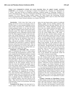
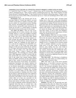
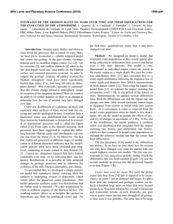
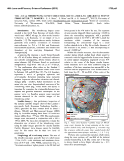
46th Lunar and Planetary Science Conference (2015)
1208.pdf
MODELLING DIAGENESIS OF GALE CRATER SEDIMENTARY ROCKS: SCENARIOS TESTABLE
BY THE CURIOSITY ROVER. C.S. Borlina1,2, B.L. Ehlmann2,3, 1Department of Atmospheric, Oceanic and
Space Sciences, University of Michigan, Ann Arbor, MI, 2Division of Geological and Planetary Sciences, California
Institute of Technology, Pasadena, CA, 3Jet Propulsion Laboratory, California Institute of Technology, Pasadena,
CA.
Introduction: Gale Crater, landing site of the
NASA Mars Science Laboratory (MSL) mission, has a
unique sedimentary stratigraphy, preserved in 5-km
high Mt. Sharp. The history of its sedimentation, erosion, and secondary mineral formation preserves a record of changing geologic processes, climate and habitability on early Mars and determines the preservation
potential of organics within its sedimentary rocks. We
model heat flow and depths of burial to predict the
temperature history of sedimentary rocks presently
exposed at the surface, providing scenario-dependent
predictions of diagenetic mineralogy in locations between Yellowknife Bay and upper Mt. Sharp that will
be visited by the MSL Curiosity rover.
Model: We consider two formation scenarios: (1)
complete filling of Gale crater followed by partial removal of deposited sediments [1] or (2) building of a
central deposit with morphology controlled by slope
winds and only incomplete sedimentary fill of Gale
crater [2]. Model inputs are described below [for complete methods, 3].
Pristine and modern topography: The pristine
topographic profile was determined based on observed
crater depth-diameter relationships from the MOLA
dataset [4- 7]. We set the initial shape of Gale Crater to
be 154 km in diameter and 5 km deep with a central
peak height of 1.55 km. To have realistic slopes, we
scaled the average topographic profile from Moreux
crater (45E, 42N) to fit Gale's parameters. The modern
average profile was used as the model endpoint.
Sedimentation Scenarios: Figure 1 shows the time
evolution of the considered scenarios. Scenario 1 is
characterized by a complete fill of the crater to the
peak of Mt. Sharp, followed by partial erosion, leaving
the modern shape of Mt. Sharp as final output [1]. Sedimentation and erosion rates are computed linearly
based on the defined timescales (discussed below) for
erosion/sedimentation processes and necessary burial/erosion height. Scenario 2 [2] is defined by an aeolian process where the mound grew close to the center
of the crater with the surrounding topography creating
strong mound-flank slope winds capable of eroding the
mound. Scenario 2a is defined with a constant deposition rate: the mound grows tall with a relatively constant width over time. Scenario 2b has a linearly decreasing deposition rate over time, and the mound
grows wide then steepens and narrows.
Timescales: Pinning surface ages based on crater
counts in absolute time is challenged by the existence
of different chronology models [8] yet necessary for
tying burial history to models of the secular cooling of
Mars. Consequently, we examine three different temporal models for the fill and exhumation of Mt. Sharp:
(1) a standard model, (2) a maximum diagenesis model, and (3) a minimum diagenesis model. For (1), Mt.
Sharp formation begins at 3.7 Ga, reaches 5 km in
height, and is then exhumed to reach its present extent
by 3.3 Ga. For (2), Gale crater and Mt. Sharp form
early, 3.85 Gyr, and Mt. Sharp is exhumed late, 3.0
Gyr, thus providing a maximum for heat flow and duration of burial. For (3), Mt. Sharp forms late, 3.6 Gyr
and is quickly exhumed by 3.4 Gyr.
Thermal model: We use the one-dimensional
steady-state heat conduction solution that describes the
temperature T as a function of the depth, z, and time, t:
where T0 is mean surface temperature, q(t) is heat flow
as a function of time, k is thermal conductivity, ρ is
density and H(t) crustal heat production as a function
of time. We define ρ = 2500 kg/m3 and k = 2 W/m°C,
values typical for average sedimentary rocks [9]. We
examine two possibilities for early Mars mean surface
temperature: T0 = 0°C and T0 = -50°C. The first presumes a warmer early Mars where temperatures rou-
Figure 1: Temporal evolution of Mt. Sharp under different scenarios. The dark red line is the model endpoint.
46th Lunar and Planetary Science Conference (2015)
1208.pdf
in situ unless driven by salty
brines. Scenario 2a implies that
swelling clays like smectites (if
formed in subzero temperatures
or by another process) should be
the dominant clay from Yellowknife Bay and Mt. Sharp. Scenario 2b predicts liquid water at Mt.
Sharp that could facilitate diagenetic transitions, though temperatures above 40ºC are not reached.
Under Scenario 2b, at Yellowknife Bay the 0ºC threshold is
not reached, and only freezing
point-depressed brines are perFigure 2: (a) shows MSL’s traverse. (b) and (c) show the maximum tempera- mitted.
ture expecienced in the past by sedimentary rocks along MSL’s traverse.
For
warm
early
Mars
(T0=0⁰C), liquid water that might
tinely exceed the melting point of water ice during
cause alteration and diagenesis would be available
large portions of the Martian year; the latter represents
everywhere between Yellowknife Bay and Mt. Sharp
modern-day average equatorial temperature. Finally,
under all scenarios. Maximum temperatures greater
q(t) and H(t) were estimated by curve-fitting geophysithan 100ºC occur at both Yellowknife Bay and Mt
cal models for the evolution of heat flow [10] and crusSharp i n scenario 1, strongly favoring transformation
tal heat production [11], respectively, through time.
of smectites to illites or chlorites. In both Scenarios 2a
MSL’s traverse: In order to locate MSL traverse
and 2b, temperatures above 40ºC are reached at Mt.
locations (Fig. 2a), we compute the ratio between the
Sharp, while only in Scenario 2b is this threshold exdistance of the closest rim to Yellowknife Bay and the
ceeded at Yellowknife Bay.
distance of the rim to the base of Mt. Sharp. This is
Conclusions: Mineralogical predictions for locanecessary because different models output mounds of
tions close to Yellowknife Bay vary with the choice of
different widths, and proper location of the rover relaa cold or warm early Mars and the Mt. Sharp sedimentive to the mound is crucial for computation of overtation scenario. For (1), temperatures experienced by
burden rates. Yellowknife Bay is at 0.93 of the dissediments should decrease monotonically over the
tance between the closest rim and the foothill of the
traverse and up Mt. Sharp stratigraphy, whereas for (2)
output mound. The unconformity is at a point ~1000 m
maximum temperatures are reached in the lower units
higher than Yellowknife Bay. This range represents
of Mt. Sharp and thereafter decline or hold roughly
MSL’s future traverse range.
constant. Under partial fill scenarios, evidence of diaResults: In Scenario 1, with the time period equalgenesis at higher temperatures is expected as MSL
ly split into an interval of net erosion followed by inmoves towards Mt. Sharp, with peak temperatures
terval of net deposition, average rates of erosion and
reached prior to the unconformity. Comparing our predeposition are 6-27 µm/yr and 8-34 µm/yr, respectivedictions with future MSL results on secondary mineral
ly. In Scenario 2a average erosion rates fall between 5assemblages, their spatial variation as a function of
21 µm/yr, while average deposition rates range from 5location on the traverse, and age of any authigenic
21 µm/yr. In Scenario 2b average erosion rates are 7phases will constrain the timing and timescale of Mt.
29 µm/yr while deposition rates range from 8-35
Sharp formation, paleosurface temperature, the availaµm/yr. These rates moderately exceed estimated erobility and setting of liquid water on early Mars, and the
sion rates elsewhere on early Mars, 0.7-10 µm/yr, but
organic preservation potential of these deposits.
are at the lower end of erosion rates from Earth, 2Acknowledgements: Thanks to E. Kite for sharing his code to
100µm/yr [12].
create slope-wind elevation profiles, the Caltech SURF program for
For a cold early Mars (T0=-50⁰C), Scenario 1 leads
the summer internship opportunity, and the MSL participating sciento conditions where water would be liquid and, if water
tist program for partial support.
References: [1] Malin & Edgett (2000) Science, 290 [2] Kite et
were present, smectite would be transformed to illite or
al (2013) Geology, 41 [3] Borlina & Ehlmann, submitted, JGR [4]
chlorite everywhere from Yellowknife to Mt. Sharp.
Garvin et al (2003) 6th Mars Science Conf [5] Boyce & Garbeil
Maximum temperatures reached are ~100ºC and ~70ºC
(2007) GRL 34 [6] Robbins & Hynek (2012), JGR, 117 [7] Kalynn
at Yellowknife Bay and Mt. Sharp, respectively (Fig.
et al (2013) GRL 40 [8] Werner & Tanaka (2011) Icarus, 215, [9]
Beardsmore & Cull (2001) [10] Parmentier & Zuber (2007) JGR 112
2b and 2c). Scenario 2a does not generate conditions
[11] Hahn et al (2011) GRL 38 [12] Golombek et al (2006) JGR 111
above 0ºC; there would be no alteration or diagenesis

© Copyright 2026