
2955
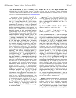
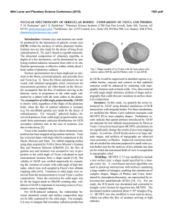
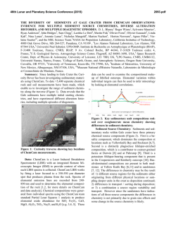
46th Lunar and Planetary Science Conference (2015)
2955.pdf
HAYABUSA AND DAWN IMAGE CONTROL FROM GENERATION OF DIGITAL ELEVATION
MODELS FOR MAPPING AND ANALYSIS. Kris J. Becker1, Robert W. Gaskell2, Lucille LeCorre2, Vishnu
Reddy2, 1U. S. Geological Survey, Astrogeology Science Center, 2255 N. Gemini Dr., Flagstaff, AZ, 86001
([email protected]), 2Planetary Science Institute, Tucson, AZ, 85719.
Introduction: Images returned from the Hayabusa
[1] and Dawn [2] missions have been used to create
digital elevation models (DEM) [3,4] from the same or
similar stereophotoclinometry (SPC) technique [5].
Image data from the Asteroid Multiband Imaging
Camera (AMICA) on Hayabusa spacecraft and the
Framing Camera (FC) on Dawn were used in the generation of shape models for asteroids (25143) Itokawa
and (4) Vesta, respectively. These DEMs will be used
to create International Astronomical Union (IAU)
compatible, high quality orthorectified color maps of
Itokawa and Vesta for photometric and mineral composition analysis. The maps, created from the same
images used to create the DEMs, will be highly correlated with the DEM through image control using leastsquares adjustment techniques.
For our work, we will evaluate the individual image control for accuracy and color set alignment of
global maps for analysis purposes. A small comparison
study will be made with results using Integrated Software for Imagers and Spectrometers (ISIS) [6] control
techniques [7] to assess the need for higher refinement
in the image position and pointing to achieve the required precision. ISIS has camera models for both the
AMICA and FC instruments. This work will result in
refined Navagation and Ancillary Information Facility
(NAIF) Camera Kernel (CK) and Spacecraft and Planet Kernel (SPK) datasets to be made public through
distribution by the Planetary Data System (PDS).
Image Control: Critical to the accuracy of any
DEM created from planetary images is control of the
image set using rigourous photogrammetric, stereo
and/or photoclinometry techniques. Although the techniques are varied to create DEMs, the foundation of all
approaches is image control. This is required since
there are uncertainties in the CK and SPK kernels provided by navigation and mission operations teams.
The objective of image control is to re-establish the
exterior orientation (position/pointing) of the images at
the time of exposure. Proper alignment of surface features is critical in establishing ground truth for the
matching of common features among images.
In the SPC process used by Gaskell to derive
DEMs, SUMFILES for each image are created that
contain the corrected spacecraft position and pointing
vectors in body-fixed coordinates. These data are used
to create new SPK and CK kernels, respectively. These
kernels will then be used by the ISIS spiceinit application to apply the updated ephemeris for each image.
Note a requirement for this approach is that every image used in the maps must also be used in the creation
of the DEM. If this requirement cannot be met, then
additional image processing techniques may be required in order to properly align color image data sets.
The images are then projected to cartographic maps
using ISIS’ efficient orthorectification algorithms [8].
Hayabusa Data Sets: The Hayabusa AMICA instrument collected 1,662 images of which 1,319 images are of asteroid Itokawa.
The DEM created from these images [3] is archived at the PDS Small Bodies Node
(http://sbn.psi.edu/pds/resource/itokawashape.html)
and is shown in Figure 1. Seven band global color
maps will be created from the AMICA data set using
SPK and CK kernels created from the DEM process.
Figure 1. Rendering of the DEM of asteroid Itokawa.
Dawn Data Sets: The Dawn FC image data set is
comprised of images acquired during the High Altitude
Mapping Orbit (HAMO) 1 and HAMO2 phases of the
Vesta mapping encounter. HAMO1 contributes 4,425
color frame sets and HAMO2 has 1,322 color sets.
These data sets will be used to create a fully restored
global seven color band map.
In addition to global color maps, we will create a
global map with the FC clear filter. HAMO1 has 2,557
and HAMO2 provides 2,785 clear filter images for this
map.
46th Lunar and Planetary Science Conference (2015)
The DEM used for orthorectification of all these
maps is a derivation of the Gaskell 2013 final DEM,
shown in Figure 2, and is available at the Dawn Public
Data
site
(http://dawndata.igpp.ucla.edu/tw.jsp?section=geometr
y/ShapeModels/GASKELL_CLAUDIA_2013_02_13).
However, this DEM is in the Claudia [9] coordinate
system and will require additional processing to convert it to the IAU coordinates.
Figure 2. Vesta DEM in Claudia coordinate system serves as
the basis for Dawn FC processing.
Summary: The Hayabusa AMICA and Dawn FC
DEMs are derived using the SPC shape model process.
Inherent in this process is image control of the complete data sets used in creating high quality, orthorectified color cartographic maps for data analysis. The
similarity of the objectives of these two efforts provides us the opportunity to derive one solution that
satisfies objectives for both projects. The results of this
work will be made available through the PDS.
Acknowledgements: The Hayabusa component of
this work is funded by the NASA Planetary Mission
Data Analysis Program Program Grant NNX13AP27G
(PI: Reddy) and Dawn component is funded by NASA
Planetary Mission Data Analysis Program Program
Grant NNX14AN16G (PI: Le Corre).
References: [1] Fujiwara A. et al. (2006) Science,
312, 1330-1334. [2] Russell C.T. et al. (2011) Science
336, 684-686. [3] Gaskell R.W. (2006) LPSC
XXXVII, Abstract #1876. [4] Gaskell R.W. (2012)
AAS/DPS 44, Abstract #209.03. [5] Gaskell, R.W.
(2006) LPSC XXXVII, Abstract #3001. [6] Anderson
J. A. et al. (2004), LPSC abstract #2039. [7] Edmundson K.L. (2012) ISPRS, PRSSIS, 1-4, 203-208. [8]
Anderson J.A. (2013) LPSC XLIV, Abstract #2069.
[9]
Li
J.
(2012)
PDS,
(http://sbn.psi.edu/archive/dawn/fc/old/DWNVFC2_1
A/DOCUMENT/VESTA_COORDINATES/VESTA_
COORDINATES_120918.PDF)
2955.pdf
© Copyright 2026