
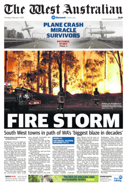
150203 2100 Lower Hotham Emergency Warning Area with Fire
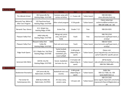
116°15'
430000
BODDINGTON
Y AR
K
L B ROO K
OW
S
O
E BR
Dwellingup
State
Forest
UR
LO
6345000
E
G U E B RO
CLAR
OK
KE BR
OOK
E
OK
CRE
EK
E
IV
E
E
E
E
E
E
E
WI
LL
RO
LLY
RI
E NG G
UL
LY
SB
TO
CK
IS
E R IVE R
6325000
405000
116°
410000
415000
116°5'
420000
116°10'
425000
430000
116°15'
435000
116°20'
440000
445000
116°25'
HA
M
450000
The Dept. of Fire and Emergency Services does not guarantee that this map is without flaw of any kind and
disclaims all liability for any errors, loss or other consequence which may arise from relying on any information depicted.
Roads and tracks on land managed by DPaW may contain unmarked hazards and their surface condition is variable. Exercise caution and drive to conditions on all roads.
COL L IE
-W
Y
IL LIA M S RD
455000
116°30'
460000
116°35'
Incident Authority: Public Distribution
º
(A4)
0
1:275,000
1.75
3.5
Kilometres
Projection: Universal Transverse Mercator
MGA Zone 50. Datum: GDA94
L
G
BIN
R
R I VE
UL
400000
115°55'
E
E
E
E
IN G
AK
RR
OL
CO
E
BROOK
RIVERE
WILLIAMS (S)
RD
HA
YA
CRE
EK
E
E
E
S
OLD
TAYLOR
GU
SP
COLLIE (S)
ER N EST
QUINDANNING
K
M
ER
G GU LL Y
NIN
OO
River
State
Forest
R IV
RE
BR
E
E Harris
SU
E
E
MS
L
BE
LUP
OS
IA
L
OP
E
WEO
KA
LL
FA
BIGEBRO
OK
HA
RV
EY
R I V ER
6365000
E
OK
HARV EY (S)
Fireshape at 20:33 03/02/2015
Emergency Warning Area
ER
Range
Darling
E
E
E
RA
YR
Map produced at 2100, Feb 3, 2015
6355000
E
E
E
M AR
IA
Public Information
Map
Lower Hotham
6360000
G
LO
N
STO
NE Y
ILL
6335000
CE
L
PIN J ARRA-W
6325000
6350000
6355000
B AN
LLY
BODDINGTON (S)
WATEROUS
O
GU
H
E
BI G
O N BROOK
BROOK
K
RO
WA R O O N A ( S )
E
E
E
E
E
E
E
WA
R
OO
OO
BR
NG
DO
RD
-32°55'
RANFORD
MS
YALU
E
M
-33°
R
RIVE
R
6370000
-32°50'
6365000
HAMEL S A MS
BR
DR A KES
K
-33°5'
6340000
AM
H O TH
OK
RO
116°35'
460000
RA
6360000
WAROONA
B
6335000
116°30'
455000
450000
Y
E
P
-33°10'
6330000
IL B
116°25'
445000
440000
HW
AG
116°20'
A NY
AL B
M U R R AY ( S )
435000
6370000
425000
-32°50'
116°10'
-32°55'
420000
6350000
-33°
116°5'
415000
6345000
410000
6340000
-33°5'
116°
405000
6330000
-33°10'
115°55'
400000
Produced by the
Department of Fire &
Emergency Services
7


© Copyright 2026