
Feasibility Report 03 - Green Line Bus Rapid Transit System
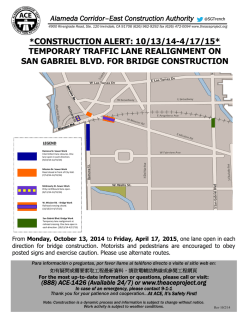
Karachi Transportation Improvement Project
Final Report
APPENDIX-1 PRE-FEASIBILITY STUDY OF BLUE LINE
1.
Outline of Blue Line
1.1
Blue Line in Master Plan Network
The master plan network in KUTMP 2030 is shown in Figure A1-1-1.
as Railed-base system.
Blue Line is proposed
Source; KTIP
Figure A1-1-1
1.2
Master Plan Network in KUTMP 2030
Implementation Plan of Blue Line
Figure A1-1.2 shows the proposed schedule of mass transit lines in KUTMP 2030. It is
assumed that a rail-base project takes seven years to be implemented, while BRT project takes
five years.
Appendix 1 - 1
Karachi Transportation Improvement Project
Code Name
Shor-term
Type
2012
KCR
KCR Extension
Blue Line
Brown Line
Green Line
Red Line
Purple Line
Orange Line
Yellow Line
Aqua Line
Silver Line
Final Report
2013
2014
2015
2016
2017
Mid-term
2018
2019
2020
2021
2022
2023
2024
Long-term
2025
2026
2027
2028
2029
2030 2030-
MRT
MRT
LRT
LRT
BRT
BRT
BRT
BRT
LRT
BRT
LRT
Source: KTIP
Figure A1-1-2
Master Plan Schedule (Mass Transit Projects)
2.
Purpose for Pre-Feasibility Study of Blue Line
2.1
Issues on Developing of Blue Line
According to the implementation plan of Blue Line in KUTMP 2030, following issues are
pointed out against the implementation timing of LRT Blue Line.
1) The growth in population and the expansion in urbanized areas would certainly bring about a
rapid increase in traffic demand in Karachi City.
2) There are only four years between construction commencement of LRT Blue Line and
completion of Green and Red BRT line.
3) As a result of above 1) and 2), alternative public transportation system to LRT along Blue
Line would be required before construction of LRT.
Thus, the JICA Study Team proposes an alternative plan along BRT divided into following two
phases taking into account above mentioned matters.
- Phase-1; Adopting Semi-BRT system before construction of LRT Blue Line after completion
of BRT Green Line and Red Line.
- Phase-2; Adopting LRT system after the commencement of LRT construction
2.2
Purpose for Pre-Feasibility Study of Blue Line
In case the alternative Blue Line plan is adopted, following issues are pointed out from the
perspective of introducing space for both transportation system, tentative BRT system and LRT
system.
1) BRT system would be required during only four years before construction of LRT system
according to the implementation schedule. In addition to construction of BRT facility, removal
of tentative BRT facility would also become an important issue so that tentative BRT facility
should become removal easily.
Appendix 1 - 2
Karachi Transportation Improvement Project
Final Report
2) A large space is required for the accommodation of LRT facility along the route permanently
due to elevated structure or underground structure including station structure.
3) On the other hand, new flyovers would be designed and constructed in the near future as
necessary countermeasure against rapid increasing traffic volume in Karachi.
JICA Study Team has carried out the study about necessary space for both transportation
systems in different phases so that both systems would be easily introduced without any
hindrance in the near future.
Purpose of this study consists of;
-
Proposing introducing space, station locations and structures, and countermeasure against
obstacles if any, for tentative BRT system of Blue Line as short-time.
Proposing introducing space as elevated or underground, station locations and structures,
transition section plan, terminal tower station, and countermeasure against obstacles if any, for
LRT system of Blue Line
3.
Study of Introducing Space for Blue Line
3.1
Introducing Space for BRT System during Short-term
3.1.1
BRT System of Blue Line as Short-Term
There are two major types of cross section design for BRT. One is to set the station at the
center of the road, and another is at curb-side, which would determine the side of the door of
BRT bus.
BRT buses of Green Line and Red Line run just through the dedicated lanes except for
intersections. And station place is designed at a center of the road for the right door buses, as
described in this report Vol. 2.
On the other hand, JICA Study Team proposes that tentative BRT system of Blue Line during
short-term run in mixed traffic lanes and station place is set on curb-side for left-door buses.
The major reasons for this selection are as follows;
-
-
-
In case of the center station for the right door buses, pedestrian bridges would be necessary for
access between both sidewalk and BRT station. However, pedestrian bridges would become
obstructive to the space for LRT structure in the future.
In additional construction of high height platform would be required at each center station and
removal of platform become also necessary before construction of LRT facility.
Jahangir Road and one-way sections in M.A.Jinnah Road are too narrow to construct the center
station of BRT. But construction of the curb-side stations would be possible.
At the crossing section with KCR, Tentative BRT Blue Line should be designed as elevated
structure because KCR is designed at grade. Then tentative BRT lane should be set up in the
space of the Liaquatabad Flyover. Although there is no space of the center station, there still
would be enough space of curb-side station by constructing elevated platforms at both side of
the flyover.
In case of constructing mixed traffic lane and curb-side stations for tentative BRT, it is possible
to make not only initial investment much smaller, but also use of existing buses effective.
Appendix 1 - 3
Karachi Transportation Improvement Project
3.1.2
Final Report
BRT route of Blue Line
Tentative BRT route and proposed station locations are shown in Figure A1-3-1 Station
distance is set on every around 500 m.
Super Highway
Rashid Minhas Road
Shah Jehan
Avenue
Lyari Express Way
Sohrab
Goth
Water-pump
n
ta
s
i
k
ve r
a
dF
lyo
Sh
Pa
eah Ayesha Manzil
hr
ri R
Lya
iver
tab
a
Liaquatabad #10
Dakahana
Business
Recorder
Street
Lia
qua
Ka r a
Un
Gurumadir
y
sit
r Rai
c
ad
Jah
Roaangir
d
Teen Hati
r
ive
Ro
rcula
hi Ci
Mazar-e-Quaid
Jamia Cloth Market
Pr
ee
d
tr
yS
ee
t
Regal Chowk
Tower
I.I.Chundrigar Road
Karachi Port
Source: Illustrated by JICA Study Team
Figure A1-3-1
3.1.3
(1)
BRT Route and Station Location
Study of Introducing Space for Tentative BRT
Sohrab Goth
BRT lane is designed at both sides in mixed traffic lanes as shown in Figure A1-3-2
Appendix 1 - 4
lway
Karachi Transportation Improvement Project
Final Report
BRT Lane
Median
6.0 m
Rashio Minhas Road
Sohrab Goth
BRT Lane
Median
Median
Median
Median
Median
Shahrah-e-Pakistan
13.8 m
13.0 m
Shahrah-e-Pakistan
14.5 m
Source: Illustrated by JICA Study Team
Figure A1-3-2
(2)
Cross Section of BRT Blue Line at Sohrab Goth
Shahrah-e-Pakistan Road
BRT lanes are designed to be set at both sides in mixed traffic lanes as shown in Figure A1-3-3
66.6 m
3.6 m
6.4 m
1.8 m
14.9 m
13.5 m
14.9 m
1.3 m 7.0 m
3.2 m
Service
Road
Service
Road
Sidewalk
Shahrah-e-Pakistan
Sidewalk
Shahrah-e-Pakistan
BRT Lane
BRT Lane
Median
Median
Median
Source: Illustrated by JICA Study Team
Figure A1-3-3
(3)
Cross Section of BRT Blue Line along Shahrah-e-Pakistan Road
Cross section with KCR
BRT lane and stations are designed at both sides in mixed traffic lanes as shown in Figure
A1-3-4. Both BRT stations and platforms are designed as elevated structure at both side of
flyover.
86.0 m
1.2 m
9.1 m
9.4 m
20.1 m
18.9 m
1.2 m
Shahrah-e-Pakistan
Liaquatabad Flyover
BRT Lane
13.3 m
9.2 m
3.6 m
Shahrah-e-Pakistan
Liaquatabad Flyover
BRT Platform
BRT Lane
BRT Platform
Service
Road
Open Space
Sidewalk
Service
Road
Sidewalk
Source: Illustrated by JICA Study Team
Figure A1-3-4
Cross Section of BRT Blue Line with KCR
Appendix 1 - 5
Karachi Transportation Improvement Project
(4)
Final Report
Section along Liaquatabad Flyover
BRT lane and stations are designed at both sides in mixed traffic lanes as shown in Figure
A1-3-5. Both BRT station and platforms are designed as elevated structure at both side of
flyover.
86.9 m
2.7 m
12.4 m
31.9 m
1.4 m
12.3 m
6.9 m
6.4 m
8.7 m
Service
Road
Sidewalk
4.2 m
Service
Road
BRT Lane Shahrah-e-Pakistan BRT Lane
Liaquatabad Flyover
BRT Platform
BRT Platform
Service Road
Median
Sidewalk
Source: Illustrated by JICA Study Team
Figure A1-3-5 Cross Section of BRT Blue Line along Liaquatabad Flyover
(5)
Shahrah-e-Pakistan
BRT lane is designed at both sides in mixed traffic lanes as shown in Figure A1-3-6
60.9 m
2.1 m
21.1 m
23.7m
Shahrah-e-Pakistan
3.0 m
Shahrah-e-Pakistan
Sidewalk
Sidewalk
BRT Lane
Median
BRT Lane
Source: Illustrated by JICA Study Team
Figure A1-3-6 Cross Section of BRT Blue Line along Shahrah-e-Pakistan
(6)
Lyari River Bridge
BRT lane is designed at both sides in mixed traffic lanes as shown in Figure A1-3-7
Appendix 1 - 6
Karachi Transportation Improvement Project
Final Report
BRT Lane
6.0 m
Lyari Express Highway
BRT Lane
Lyari River Bridge
Median
Sidewalk
2.4 m
Sidewalk
3.1 m
13.3 m
2.0 m
16.5 m
Shahrah-e-Pakistan
37.3 m
Source: Illustrated by JICA Study Team
Figure A1-3-7 Cross Section of BRT Blue Line on Lyari River Bridge
(7)
Cross Section of Jahangir Road
BRT lane is designed at both sides in mixed traffic lanes as shown in Figure A1-3-8
Jahangir Road
2.4 m 8.3 m
23.1 m
8.5 m
3.3 m
0.6 m
Side
walk
Side
walk
BRT Lane
BRT Lane
Source: Illustrated by JICA Study Team
Figure A1-3-8 Cross Section of BRT Blue Line along Jahangir Road
(8)
Cross section of M.A.Jinnah Road
BRT lane is designed at both sides in mixed traffic lanes as shown in Figure A1-3-9
Appendix 1 - 7
Karachi Transportation Improvement Project
Final Report
M.A.Jinnah Road
4.4 m
17.5 m
45.8 m
2.3 m
5.6 m
16.0m
BRT Lane
BRT Lane
Sidewalk
Sidewalk
Source: Illustrated by JICA Study Team
Figure A1-3-9 Cross Section of BRT Blue Line along M.A.Jinnah Road
(9)
Cross Section of M.A.Jinnah Road (One-way section)
BRT lane and stations are designed mainly at east side in mixed traffic lanes and west side BRT
would possibly be introduced as shown in Figure A1-3-10.
M.A.Jinnah Road
(Oneway)
3.5 m
16.8 m
BRT Lane
23.3 m
3.0 m
BRT Lane
Side
walk
Side
walk
If possible to
intoduce
Source: Illustrated by JICA Study Team
Figure A1-3-10 Cross Section of BRT Blue Line along M.A.Jinnah Road (One-way section)
Appendix 1 - 8
Karachi Transportation Improvement Project
Final Report
3.2
Introducing Space for LRT Blue Line
3.2.1
Structure of Railway
(1)
Rolling Stock
A car used for the Light Rail Transit (LRT) shall be the typical size of EMU (Electric Multiple
Unit), of which length is around 20 meters, and the width is 3 meters. JICA Study Team
proposes basic rolling stock gauge and structure gauge of the LRT car as shown in Figure
A1-3-11.
Source: Illustrated by JICA Study Team
Figure A1-3-11 Rolling Stock Gauge and Construction Gauge
(2)
Design Criteria
Design criteria concerning decision against the introducing space for LRT is shown in Table
A1-3-1
Table A1-3-1
Alignment Design Criteria
No.
Items
1
Track Gauge
2
Design Maximum Speed
3
Minimum Curve Radius
4
Maximum Gradient
Technical Features
1,435 mm
90 – 110 km/h
Main Line: R=160m
Platform: R=400m
Siding / Depot: R=100m
Outside platform: 35 ‰
Platform : 2 ‰
Depot: Level
Source: JICA Study Team
JICA Study Team assumed Six-cars train formation in this study. One set of six cars train
requires 130m length of platform for both elevated and underground station.
Appendix 1 - 9
Karachi Transportation Improvement Project
(3)
Final Report
Elevated Structure
1)
Elevated structure section between stations
Elevated LRT structure section between stations is designed as shown in Figure A1-3-12.
Minimum width for introducing space of LRT lane would be 11.0m.
11.0 m
30 m
Ground level
Ground level
Pile,
if necessary
Pile, if necessary
Source: Illustrated by JICA Study Team
Figure A1-3-12 Elevated Structure of LRT
2)
Elevated Station Section
Necessary facilities for LRT elevated station such as platform, lifts, and station facility space
would be designed as shown in Figure A1-3-13. Cross section of elevated station is shown in
Figure A1-3-14, A1-3-15. Minimum width of elevated station would be 18-22 m and length of
elevated station would be 130m.
Platform length 130 m
Side type platform
Six-car train
Double track
Lift
Stair & Escalator
Lift
Free Concource
Facility
Spase
Paid
Concource
Entrance & Exit
Facility
Space
Stair & Escalator
Station length 130 m
Source: Illustrated by JICA Study Team
Figure A1-3-13 Elevated Station Plan
Appendix 1 - 10
Karachi Transportation Improvement Project
Final Report
Station width 18-22 m
Platform
Width 5.5-7.5m
Paid & FreeConcource
Roadway
Mdeian
Entrance & Exit
Ramp & Stair
Roadway
Source: Illustrated by JICA Study Team
Figure A1-3-14 Elevated Station Supported by the Centre Pier
Station width 18-22 m
Platform
Width 5.5-7.5m
Paid & FreeConcource
Roadway
Median
Entrance & Exit
Ramp & Stair
Roadway
Source: Illustrated by JICA Study Team
Figure A1-3-15 Elevated Station Supported by the Rigid-frame
(4)
Underground Structure
1)
Tunnel between underground stations
Figure A1-3-16 shows cross section of the tunnel between underground stations.
Sidewalk
Sidewalk
φ7 m
7m
φ7 m
Source: Illustrated by JICA Study Team
Figure A1-3-16 Cross Section of Shield Tunnel
Appendix 1 - 11
Karachi Transportation Improvement Project
2)
Final Report
Standard Underground Station
LRT facilities for underground station such as platform, lifts and other station facility would
generally be designed as shown in Figure A1-3-17. Cross section of an underground station is
shown in Figure A1-3-18. Minimum width of the underground station section would become
19-21m, and length would become 200m.
Free Concource
Entrance & Exit
Paid concourse
Station facility space
Station facility space
Stair & Escalator
Lift
Station length 200 m
Shield tunnel
Shield tunnel
Lift
Facility
rooms
Facility
rooms
Stair & Escalator
Six-car train
Platform length 130 m
Source: Illustrated by JICA Study Team
Figure A1-3-17 Underground Station Plan
B1 floor
Paid & FreeConcource
B2 floor
Platform
Station depth 18 m
Entrance & Exit
Entrance & Exit
Station width 19-21 m
Source: Illustrated by JICA Study Team
Figure A1-3-18 Cross section of Underground Station
3)
Underground Station in case of narrow road
In case of planning underground station under narrow road, two-stories platform type is
recommended as shown in Figure A1-3-19. That cross section is shown in Figure A1-3-20.
Minimum width of the station would become 12-14m, and length would become 200m.
Appendix 1 - 12
Karachi Transportation Improvement Project
Final Report
Free Concource
Entrance & Exit
Paid concourse
B1 floor
Station facility space
Station facility space
Stair & Escalator
Lift
Shield tunnel
B2 floor
Shield tunnel
Station length 200 m
Lift
Facility
rooms
Facility
rooms
Platform
Stair & Escalator
Six-car train
B3 floor
Station Facility spaces
B4 floor
Platform
Lift
Facility
rooms
Stair & Escalator
Facility
rooms
Six-car train
Platform length 130 m
Source: Illustrated by JICA Study Team
Figure A1-3-19 Two-stories Platform Type of Underground Station
Entrance & Exit
Entrance & Exit
B2 floor
B3 floor
B4 floor
Platform
StationF
acility
spaces
Station depth 28 m
Paid &
FreeConcource
B1 floor
Platform
Station width 12-14 m
Source: Illustrated by JICA Study Team
Figure A1-3-20 Cross section of Two-stories Platform Type of Underground Station
Appendix 1 - 13
Karachi Transportation Improvement Project
3.2.2
Final Report
LRT Blue Line Route
LRT route and proposed station locations are shown in Figure A1-3-21. Distance between
stations is designed every about 1000 m.
Super Highway
Rashid Minhas Road
Lyari Express Way
Sohrab Goth
dF
l yo
ver
Water-pump
Shahrah-e-Jahangir
n
ta
s
i
k
Pa
eh
ra Ayesha Manzil
h
a
Sh
k6
L=
8
er
on
o
yR
t
i
s
ch
ular
i C i rc
Railw
ay
ad
Ja h
Roaangir
d
cti
Se
nd
Kara
iv
Un
Teen Hati
Gurumadir
rg r
r
qua
Business Recorder
Road
ou
R i ve
ri
Lya
Lia
00
m
Dakahana
tab
a
Liaquatabad #10
Un
de
Mazar-e-Quaid
Jamia Cloth Market
Pre
ed
e
tre
yS
t
Regal Chowk
Tower
Legend
Elevated
Underground
Elevated station
Underground station
I.I.Chundrigar Road
Karachi Port
Source: Illustrated by JICA Study Team
Figure A1-3-21
3.2.3
(1)
LRT Route and Proposed Station Location
Introducing Space for LRT
Sohrab Goth
Elevated LRT structure is designed over Sohrab Goth Flyover and height of platform near
Sohrab Goth Intersection would be as high as 16.5m from the ground as shown in Figure
A1-3-22. Station location would be designed at one side of Flyover.
Appendix 1 - 14
Karachi Transportation Improvement Project
Final Report
6.0 m
6.0 m
ROW 11.0 m
Median
Rashio Minhas Road
Sohrab Goth
Median
Median
Median
Median
Median
Shahrah-e-Pakistan
13.8 m
Shahrah-e-Pakistan
14.5 m
13.0 m
Source: Illustrated by JICA Study Team
Figure A1-3-22
(2)
Cross Section of LRT Blue Line at Sohrab Goth
Shahrah-e-Pakistan (from Sohrab Goth to Karimabad colony old)
This section of Shahrah-e-Pakistan Road is very wide with service roads on both side and
median strip. Median trip is enough wide to introduce LRT structure as shown in Figure
A1-3-23.
66.6 m
3.6 m
6.4 m
1.8 m
14.9 m
13.5 m
14.9 m
1.3 m 7.0 m
3.2 m
ROW 11.0 m
Shahrah-e-Pakistan
Shahrah-e-Pakistan
6.0 m
Service
Road
Sidewalk
Median
Median
Service Sidewalk
Road
Median
Source: Illustrated by JICA Study Team
Figure A1-3-23
(3)
Cross Section of LRT Blue Line of Shahrah-e-Pakistan
Cross section with KCR
Open space is enough wide for elevated structure in KCR cross section as shown in Figure
A1-3-24. However, Electric Pylon of KESC would become an obstacle against LRT route. This
electric pylon should be relocated before construction of LRT.
Appendix 1 - 15
Karachi Transportation Improvement Project
Final Report
86 .0 m
1.2 m 9.1 m
9.4 m
20.1 m
18.9 m
1.2 m
13.3 m
3.6 m
9.2 m
ROW 11.0 m
6.0 m
Shahrah-e-Pakistan
Liaquatabad Flyover
Shahrah-e-Pakistan
Liaquatabad Flyover
Service
Road
Open Space
Open Space
Service
Road
Sidewalk
Source: Illustrated by JICA Study Team
Figure A1-3-24
(4)
Cross Section of LRT Blue Line with KCR
Section along Liaquatabad Flyover
Service road and median strip is enough wide to introduce LRT structure as shown in Figure
A1-3-25.
86.9 m
2.7 m
12.4 m
31.9 m
1.4 m
6.9 m
12.3 m
6.4 m
8.7 m
Service
Road
Sidewalk
4.2 m
ROW 11.0 m
Sidewalk
Service Road
6.0 m
Shahrah-e-Pakistan
Liaquatabad Flyover
Service
Road
Median
Source: Illustrated by JICA Study Team
Figure A1-3-25
Shahrah-e-Pakistan (from Liaquatabad#10 to Lyari River)
Width of median strip is sufficiently enough for elevated LRT structure as shown in Figure
A1-3-26.
60.9 m
2.1 m
21.1 m
Shahrah-e-Pakistan
Sidewalk
ROW 11.0 m
6.0 m
(5)
Cross Section of LRT Blue Line along Liaqutabad Flyover
23.7m
3.0 m
Shahrah-e-Pakistan
Median
Sidewalk
Source: Illustrated by JICA Study Team
Figure A1-3-26
Cross Section of LRT Blue Line along Shahrah-e-Pakistan
Appendix 1 - 16
Karachi Transportation Improvement Project
(6)
Final Report
Cross Section at Lyari River
There is no space for elevated or underground station at Teen Hati due to narrow Jahangir Road.
Transition section from elevated to underground would be located at the section between
Dakahana Intersection and Lyari River as described in.3.2.4 in Appendix-2. As a result,
underground structure would be adopted under Lyari River as shown in Figure A1-3-27.
Shahrah-e-Pakistan
37.3 m
Sidewalk
6.0 m
Lyari Express Highway
Median
Sidewalk
15.0 m
Lyari River Bridge
φ7 m
φ7 m
7m
Source: Illustrated by JICA Study Team
Figure A1-3-27
Jahangir Road
Road width is narrow for Right of Way width, 130 ft (39.6 m). Cross section of underground
tunnel is shown in Figure A1-3-28.
Jahangir Road
2.4 m 8.3 m
23.1 m
8.5 m
3.3 m
0.6 m
Side
walk
Side
walk
7.0 m
(7)
Cross Section of LRT Blue Line at Lyari River
φ7 m
7m
φ7 m
Source: Illustrated by JICA Study Team
Figure A1-3-28
Cross Section of LRT Blue Line under Jahangir Road
Appendix 1 - 17
Karachi Transportation Improvement Project
(8)
Final Report
M.A.Jinnah Road
Cross section under M.A.Jinnah road is shown in Figure A1-3-29.
M.A.Jinnah Road
4.4 m
17.5 m
45.8 m
2.3 m
5.6 m
16.0m
Sidewalk
7.0 m
Sidewalk
φ7 m
7m
φ7 m
Source: Illustrated by JICA Study Team
Figure A1-3-29
One way section in M.A.Jinnah Road
Cross section in one way section in M.A. Jinnah Road is shown in Figure A1-3-30.
M.A.Jinnah Road
(Oneway)
3.5 m
16.8 m
23.3 m
3.0 m
Side
walk
Side
walk
7.0 m
(9)
Cross Section of LRT Blue Line under M.A.Jinnah Road
φ7 m
7m
φ7 m
Source: Illustrated by JICA Study Team
Figure A1-3-30
Cross Section of LRT Blue Line under one way section
Appendix 1 - 18
Karachi Transportation Improvement Project
3.2.4
Transition Section between Elevated and Underground
Lyari Express Highway
ang
ir R
oad
Shahrah
ro u n
d Sta
tion
n
Un
de
rg r
a ri
Ly
Teen Hati
-e-Pakist
a
e rg
Und
Syed Alta
f Ali
Barelvi Roa
d
Jah
Final Report
Riv
er
200 m
ou
nd
Ra
ilw
Dakhana
10
480 m
W
S
ay
0m
500 m
25
Elevated
Underground
va
ted
0m
Tra
n
Legend
siti
N
E
Ele
Ra
ilw
ay
Em
on
ba
Se
c
tio
n
nk
50
me
nt
0m
25
0m
Source: JICA Study Team
Transition Section of LRT Blue Line
st
at
n
io
n
io und
at
St rgro na)
a
nd e
ou und akh
r
g st t D
r
a
de re
U n (N e a
Required minimum distance between station 1300 m
480 m
340 m
Lyari Express Highway
60 m 100 m
Embankment 250 m
250 m
250 m
3
Concourse
35
5‰
6m
Concourse
3m
15 m
φ7 m
7m
Lyari River
8m
6m
Dakhana
‰
Platform
200 m
Underground Railway
Elevated Railway
Source: Illustrated by JICA Study Team
Figure A1-3-32
Longitudinal Transition Section of LRT Blue Line
Appendix 1 - 19
at
ed
n
tio
130 m
Transition Section 500 m
U- shape tunnel
ev
El
a
St
Platform
6m 7m
13 m
Figure A1-3-31
Karachi Transportation Improvement Project
3.2.5
Final Report
Terminal of LRT (Tower Station)
Karachi Port Trust
M.A.Jinnah Road
Turn-Back 230m
Platform 130m
Crossing 110m
Station 470m(Cut &Cover Method)
Tower
Shield tunnel
M.A.Jinnah Bridge
Source: JICA Study Team
Figure A1-3-33
Terminal Station Plan (Tower Station)
11 m
Layout of track
Turn-Back section 230 m
Platform 130 m
Station 470 m ( by Cut & Cover Tunnel)
Crossing 110 m
Shield tunnel
Source: Illustrated by JICA Study Team
Figure A1-3-34
Layout plan of Track Alignment at Terminal Station (Tower station)
Appendix 1 - 20
© Copyright 2026