
AIP ROMANIA AD 2.4-1 16 OCT 2014 ROMATSA
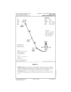
AIP
ROMANIA
AD 2.4-1
16 OCT 2014
LRBS AD 2.1 AERODROME LOCATION INDICATOR AND NAME
LRBS - BUCUREŞTI / Băneasa - Aurel Vlaicu
LRBS AD 2.2 AERODROME GEOGRAPHICAL AND ADMINISTRATIVE DATA
1
ARP coordinates and site at AD
443013N 0260613E
070° MAG 1480 M from THR 07.
8.5 km North from Bucureşti
299 FT / 24.9°C
115 FT
5°E (2010)
Compania Naţională Aeroporturi Bucureşti
Calea Bucureşti nr. 224 E, Otopeni, ILFOV
+ 40 - (0)21 - 2013304
Tel:
+ 40 - (0)21 - 2041000; + 40 - (0)21 - 2014000
Tel/Fax: + 40 - (0)21 - 2014990; + 40 - (0)21 - 3126866
LRBSRAYD
AFS:
OTPAPXH
SITA:
Aeroportul Bucureşti / Băneasa - Aurel Vlaicu
Şos. Bucureşti-Ploieşti, nr. 40, sect. 1, Bucureşti
+ 40 - (0)21 - 2320020
Tel:
Tel/Fax: + 40 - (0)21 - 2323687; + 40 - (0)21 - 2323762 (H24)
LRBSRAYD
AFS:
BSAYDRO
SITA:
IFR/VFR
Nil
2
3
4
5
6
Direction and distance from city
Elevation/Reference temperature
Geoid undulation at AD ELEV PSN
MAG VAR/ Annual rate of change
AD Administration, address, telephone,
telefax, telex, AFS
7
8
Types of traffic permitted (IFR/VFR)
Remarks
1
2
3
4
5
6
7
8
9
10
11
12
AD Administration
Customs and immigration
Health and sanitation
AIS Briefing Office
ATS Reporting Office (ARO)
MET Briefing Office
ATS
Fuelling
Handling
Security
De-icing
Remarks
1
2
Cargo-handling facilities
Fuel/Oil types
Nil
Kerosene TH type A1 / Nil
AVGAS 100LL/Nil
3
Fuelling facilities/capacity
Jet A1:
4
5
6
7
De-icing facilities
Hangar space for visiting aircraft
Repair facilities for visiting aircraft
Remarks
1
2
3
4
5
6
7
Hotels
Restaurants
Transportation
Medical facilities
Bank and Post Office
Tourist Office
Remarks
LRBS AD 2.3 OPERATIONAL HOURS
H24 see AD 2.21
H24
H24
H24
H24
H24
H24
H24
H24
H24
H24
Nil
LRBS AD 2.4 HANDLING SERVICES AND FACILITIES
- 2 refueler 20 t, 1 refueler 8 t, 1 skid mobil 0.9 t
- storage: 70 t
AVGAS:
- 1 refueler 5.5 t, 1 skid mobil 0.9 t
- storage: 30 t
1 de-icing unit with fluid type II.
Nil
Nil
Nil
LRBS AD 2.5 PASSENGER FACILITIES
ROMATSA
Hotels in the city.
Snack bar at the AD, restaurants in the city.
Buses, tram, taxis from the AD.
First aid at the AD, hospitals in the city.
Exchange Office: H24; Bank and Post Office in the city.
In the city.
Due to WIP in terminal, capacity for passenger processing is reduced.
Before filling LRBS as a destination or alternate airport contact airport
administration at LRBSRAYD, BBU AVXH, [email protected].
AIRAC AIP AMDT 09/14
AD 2.4-2
16 OCT 2014
AIP
ROMANIA
LRBS 2.6 RESCUE AND FIRE FIGHTING SERVICES
1
2
3
4
AD category for fire fighting
Rescue equipment
Capability for removal of disabled aircraft
Remarks
1
2
Types of clearing equipment
Clearance priorities
3
Remarks
1
Apron designation, surface and strength
2
Taxiway designation, width, surface and
strength
3
ACL location and elevation
4
5
INS checkpoints
Remarks
1
Use of aircraft stand ID signs, TWY guide lines
and visual docking/parking guidance system of
aircraft stands
2
RWY and TWY markings
3
4
Stop bars
Remarks
Within AD HR: CAT 7
Nil
Nil
Nil
LRBS 2.7 SEASONAL AVAILABILITY - CLEARING
1 snow blower, 2 sweepers, 4 snow ploughs, 2 spreaders
1. RWY 07/25 and associated TWY to Apron
2. Apron, ACFT stands and other TWY.
Information on snow clearance published from November-April in
NOTAM (SNOWTAM). See also the snow plan in section AD 1.2.2
LRBS AD 2.8 APRONS, TAXIWAYS AND CHECK LOCATIONS DATA
Surface:
Concrete
Strength: See details in chart AD 2.4.22
23 M
Width:
Asphalt
Surface:
Strength: 82/F/D/W/T(A), 63/F/D/W/T(D)
Location: Elevation:
THR 07
299 FT
See AD 2.4-22
Nil
THR 25
282 FT
LRBS AD 2.9 SURFACE MOVEMENT GUIDANCE AND CONTROL SYSTEM AND MARKINGS
Taxiing guidance signs at all intersections with TWY and RWY
and at all holding positions.
Guide lines at apron.
Nose-in guidance at aircraft stands.
Colour white - Designation, THR, TDZ, centre line,
RWY:
fixed distance markings, RWY side stripes;
Colour yellow - Centre line, taxi holding position
TWY:
markings, TWY designations, TWY intersection
markings, taxiing guide lines (apron);
At the holding point on TWY A and TWY D
Nil
LRBS AD 2.10 AERODROME OBSTACLES
RWY/Area
affected
a
07/APCH
25/TKOF
25/APCH
07/TKOF
In approach / TKOF areas
1
Obstacle type
Elevation
Markings/LGT
Coordinates
b
c
Antenna
443017.48N
406FT
0260510.79E
MET Station
443041.10N
442FT
0260439.78E
Antenna
443035.00N
554FT
0260414.00E
442949.04N
Building
0260428.69E
335FT
LGT
442913.00N
Building
0260213.00E
459FT
LGT
Crane
442928.00N
494FT
0260343.33E
Building
442942.32N
557FT
0260200.54E
Building
442950.99N
417FT
0260758.25E
Building
442935.72N
441FT
0260733.82E
Antenna
443216.52N
434FT
0260804.95E
Building
443149.68N
393FT
0260836.41E
AIRAC AIP AMDT 09/14
In circling area and at AD
2
Obstacle type
Elevation
Markings/LGT
Coordinates
a
b
Nil
Nil
Remarks
3
ROMATSA
AIP
ROMANIA
AD 2.4-3
16 OCT 2014
LRBS AD 2.11 METEOROLOGICAL INFORMATION PROVIDED
1
2
3
4
5
6
7
8
9
10
Associated MET Office
Hours of service
MET Office outside hours
Office responsable for TAF preparation
Periods of validity
Type of landing forecast
Interval of issuance
Briefing / consultation provided
Flight documentation
Language(s) used
Charts and other information available for briefing or
consultation
Supplementary equipment available for providing
information
ATS units provided with information
Additional information (limitation of service, etc.)
BUCUREŞTI/ Băneasa
H24
LROM
24 HR
TREND
H24
Self-briefing; briefing/consultation on request (see row 8)
Charts, tabular form, abbreviated plain language text
Romanian, English
SWC, W/T Charts, SIGMET, METAR, TAF
Tel: +40-(0)21-203 21 53
Fax: +40-(0)21-203 21 52
TWR Băneasa
Nil
LRBS AD 2.12 RUNWAY PHYSICAL CHARACTERISTICS
Designations
RWY
NR
1
07
25
Strength (PCN)
and surface of
RWY and SWY
4
64/R/D/W/T
Asphalt
THR co-ordinates
RWY end coordinates
THR geoid undulation
5
442959.27N
0260508.67E
GUND 115 FT
443025.81N
0260717.21E
TRUE BRG
2
073.89°
Dimensions of
RWY (M)
3
2960 x 45
253.91°
3100 x 45
64/R/D/W/T
Asphalt
SWY
dimensions (M)
8
Nil
CWY
dimensions (M)
9
260 x 250
Strip
dimensions (M)
10
3220 x 250
OFZ
11
Nil
Nil
Nil
3220 x 250
Nil
THR elevation and
highest elevation of
TDZ of precision
APP RWY
6
THR 299FT
THR 282FT
GUND 115 FT
Slope of
RWY-SWY
7
max 1%
max 1%
Remarks
12
RWY turn pad
Location: THR 25
Surface: Asphalt
Dimensions: 67 x 190 M
Strength: 64/R/D/W/T
Nil
LRBS AD 2.13 DECLARED DISTANCES
RWY
designator
1
07
25
TORA
(M)
2
3100
3100
TODA
(M)
3
3360
3100
ASDA
(M)
4
3100
3100
LDA
(M)
5
2960
3100
Remarks
6
THR 07 displaced 140M
Nil
REDUCED DECLARED DISTANCES
RWY
designator
1
25 “TWY D“
ROMATSA
TORA
(M)
2
1650
TODA
(M)
3
1650
ASDA
(M)
4
1650
Remarks
6
Nil
AIRAC AIP AMDT 09/14
AD 2.4-4
16 OCT 2014
AIP
ROMANIA
LRBS AD 2.14 APPROACH AND RWY LIGHTING
RWY
Designator
1
APCH
LGT
type
LEN INTST
2
ALS-II
900 M
07
25
ALS-II
660 M
RWY
Centre Line
THR LGT VASIS
LGT Length,
colour
(MEHT) TDZ,
spacing,
WBAR
PAPI
LGT LEN colour,
INTST
3
4
5
6
Green PAPI 3° White
2060 M,
WBAR
900 M
15 M, White,
LIH;
600 M, 15 M,
White/Red,
LIH;
300 M, 15 M,
Red, LIH
Green PAPI 3° White
2200 M,
WBAR
900 M
15 M, White,
LIH;
600 M, 15 M,
White/Red,
LIH;
300 M, 15 M,
Red, LIH
RWY
edge LGT LEN,
spacing, colour,
INTST
RWY
End
LGT
colour
WBAR
SWY
LGT
LEN(M)
colour
Remarks
7
140 M, 60 M,
Red/Yellow, LIH
2360 M, 60 M,
White, LIH
600 M, 60 M,
Yellow, LIH
8
Red
-
9
Nil
10
Nil
2500 M, 60 M,
White, LIH
600 M, 60 M,
Yellow, LIH
Red
-
Nil
Nil
LRBS AD 2.15 OTHER LIGHTING, SECONDARY POWER SUPPLY
1
3
ABN / IBN location, characteristics and hours of
operation
LDI location and LGT
Anemometer location and LGT
TWY edge and centre line lighting
4
Secondary power supply/switch-over time
5
Remarks
1
4
5
6
7
Coordinates TLOF or THR of FATO
Geoid undulation
TLOF and/or FATO elevation M/FT
TLOF and FATO area dimensions, surface,
strength, marking
True and MAG BRG of FATO
Declared distance available
APP and FATO lighting
Remarks
1
Designation and lateral limits
2
3
4
Vertical limits
Airspace classification
ATS unit call sign
Language(s)
Transition altitude
Remarks
2
ABN: 442944N 260459E, CNS W, H24 / IBN: Nil.
Nil
400 M from THR 07, LGT.
TWY ‘A’ and ‘D’ edge blue omnidirectional LIL and centre line
green LIL
Secondary power supply to all lighting on the AD, switch-over
time less than 1 s.
Nil
LRBS AD 2.16 HELICOPTER LANDING AREA
2
3
Nil
Nil
Nil
Nil
Nil
Nil
Nil
Nil
LRBS AD 2.17 ATS AIRSPACE
5
6
BĂNEASA CTR;
443342N0262233E - 442800N0262330E - 442800N0262000E 443025N0261400E - 442720N0255830E - 442400N0255000E 442400N0254740E - 443112N0254730E - 443005N0255635E 443342N0262233E
SFC to 2 000 FT (600 M) AMSL
C
Băneasa Tower
English, Romanian
4000 FT (1200 M) AMSL
Nil
LRBS AD 2.18 ATS COMMUNICATION FACILITIES
Service
designation
1
TWR
Call sign
2
Băneasa Tower
TWR
APP/SRE
Băneasa Ground
Bucureşti Approach
ATIS
Băneasa ATIS
AIRAC AIP AMDT 09/14
Frequency
3
120.800 MHz
121.500 MHz EMERG
129.950 MHz
118.250 MHz
120.600 MHz ALTN
126.125 MHz
Hours of operation
4
H24
Remarks
5
Nil
H24
H24
Nil
Nil
H24
Nil
ROMATSA
AIP
ROMANIA
AD 2.4-5
14 NOV 2013
LRBS AD 2.19 RADIO NAVIGATION AND LANDING AIDS
Type of aid,
MAG VAR
CAT of ILS/MLS
(For VOR/ILS/MLS
give declination)
1
LOC 07
5°E/2010
ILS CAT II
Position of
transmitting
antenna coordinates
5
443028.5N
0260730.3E
Elevation of
DME
transmitting
antenna
6
ID
2
IBS
Frequency
3
109.500 MHz
Hours of
operation
4
H24
GP 07
-
332.600 MHz
H24
443005.6N
0260519.8E
DME 07
IBS
1056.000 MHz
CH 32X
H24
443005.9N
0260519.8E
LOC 25
5°E/2010
ILS CAT II
IBN
110.500 MHz
H24
442955.3N
0260449.5E
Front course angle 3.54°.
GP 25
-
329.600 MHz
H24
443026.5N
0260702.6E
GP Angle 3°,
ILS RDH 53 FT
DME 25
IBN
1066.000 MHz
CH 42X
H24
443026.7N
0260702.4E
NDB(LO)
BSW
521 KHZ
H24
442819.5N
0255707.2E
249° MAG / 5.98 NM
from THR 07
NDB(LO)
BSE
256 KHZ
H24
443146.7N
0261349.9E
069° MAG / 4.87 NM
from THR 25
Remarks
7
Front course angle 3.8°.
Cat. II ICAO
GP Angle 3°,
ILS RDH 56 FT (17 M)
300FT
300FT
Note: Due to potential interference, the ILS instrument approach to RWY 07 at BUCUREŞTI / Băneasa - Aurel Vlaicu
aerodrome is only approved for aircraft with receivers complying the FM immunity provisions as stated in sections 3.1.4 and
3.3.8 of Annex 10, Vol. I.
Civil Aviation Authority
AIRAC AIP AMDT 12/13
AD 2.4-6
14 NOV 2013
AIP
ROMANIA
LRBS AD 2.20 LOCAL AERODROME REGULATIONS
- Nil -
LRBS AD 2.21 NOISE ABATEMENT PROCEDURES
In order to ensure noise abatement, the following rules and operating procedures shall be applied:
1.
General rules
1.1
Each aircraft operator using the airport shall ensure at all times that the aircraft is operated in a manner
calculated to cause the least disturbance practicable in areas surrounding the airport.
1.2
Ground running tests of aircraft engines is not permitted on stands.
2.
Night-time restrictions applicable between 22.00-06.00 LT
2.1
Reverse thrust other than idle thrust shall only be used to an extent unavoidable for safety reasons.
2.2
Pilots will avoid the use of auxiliary engines or auxiliary power unit (APU).
2.3
The following operations are not permitted:
a. technical or training flights (except MTOW < 5700 Kg);
b. planning and operating of flights of aircraft with MTOW ≥ 50 tones. Delayed flights are allowed to operate
on LRBS, but no later than 22.30 LT, those flights will be charged according to 2.4 and GEN 4.1-6.
2.4
The landing charges on BUCUREŞTI / Băneasa - Aurel Vlaicu are established in accordance with the MTOW of
the aircraft and the applicable ICAO Annex 16 provisions, as specified in AIP ROMANIA GEN 4.1-6.
3.
Exemptions
The night-time restrictions are not applicable for the following type of operations:
1. aircraft landing in emergency situations;
2. aircraft performing humanitarian, medical, ambulance flights, stated in the Flight plan;
3. STATE aircraft or HEAD flights, stated in the Flight plan.
AIRAC AIP AMDT 12/13
Civil Aviation Authority
AIP
ROMANIA
AD 2.4-7
07 FEB 2013
LRBS AD 2.22 FLIGHT PROCEDURES
1. LOW VISIBILITY PROCEDURES (LVP)
1.1 Description of facilities
1.1.1 Runway 07 is equipped with ILS and is approved for CAT II operations. Runways 07/25 are approved for LVTO.
1.2 Criteria for the initiation and termination of LVP
1.2.1 Approach and landing
a) The preparation phase will be implemented when visibility falls below 1500m and is deteriorated to 800m or ceiling
is 500ft and is deteriorated to 200ft and CAT II operations are expected.
b) The operations phase will be commenced when the RVR falls below to 600m (visibility falls below 800m) or ceiling
is below 200ft.
c) LVP will be terminated when RVR is greater than 600m (visibility is greater than 800m) and ceiling is greater than
200ft and a continuing improvement in these conditions is anticipated.
1.2.2 Take-off
a) LVP operations will be provided when requested by an aircraft operator to conduct LVTO when the RVR is below
400M.
b) If LVP operations are not in force, LVTO must be requested a minimum of 30 minutes in advance to permit the
appropriate preparations.
1.3 Details of runway exits
1.3.1 Runway exits are equipped with green / yellow coded taxiway centerline lights. After landing on RWY 07, BSA
TWR shall instruct the pilot to vacate the RWY via TWY A or TWY D or hold in turning bay.
1.4 Any ground movement restrictions
1.4.1 Upon receiving taxi clearance, aircraft must only proceed when a green centreline path is illuminated.
1.4.2 During LVTO, taxiing is normally restricted to one aircraft movement at a time. Operation of vehicles on the
manoeuvring area is not permitted when LVTO is in progress.
1.5 Description of LVP
1.5.1 CAT II Approach and Landing
a) Pilots will be informed by ATIS or RTF when LVP are in operation;
b) The localizer sensitive area will be protected when a landing aircraft is within 4 NM from touchdown and when an
aircraft is conducting a guided take-off.
c) ATC will provide suitable spacing between aircraft on final approach to achieve this objective.
1.5.2 Low Visibility Take Off
a) Pilots wishing to conduct a guided take-off must inform ATC on start-up in order to ensure that protection of the
localizer sensitive area is provided.
1.6 Other information
Aircraft movements on the apron must be carried out with the direction of a “FOLLOW ME” car.
Civil Aviation Authority
AIRAC AIP AMDT 02/13
AD 2.4-7
07 FEB 2013
AIP
ROMANIA
LRBS AD 2.22 PROCEDURI DE ZBOR
1. PROCEDURI ÎN CONDIŢII DE VIZIBILITATE REDUSĂ
1.1 Descrierea facilităţilor
1.1.1 Pista 07 este echipată cu ILS şi este autorizată pentru desfăşurarea operaţiunilor CAT II. Pistele 07/25 sunt
autorizate pentru LVTO.
1.2 Criterii pentru iniţierea şi terminarea LVP
1.2.1 Apropierea şi aterizarea
a) Faza de pregătire va fi implementată atunci când vizibilitatea scade sub 1500m şi are tendinţa de 800m sau
plafonul este de 500ft şi are tendinţa de 200ft şi sunt prevăzute declanşarea operaţiunilor CAT II.
b) Faza operaţională va fi declanşată atunci când valoarea RVR scade sub 600m (vizibilitatea orizontală scade sub
800m) sau plafonul este sub 200ft
c) Procedurile în condiţii de vizibilitate redusă vor fi incheiate atunci când valoarea RVR este mai mare de 600m
(vizibilitatea orizontală este mai mare de 800m) şi plafonul este mai mare de 200ft si este anticipată îmbunătăţirea
continuă a acestor condiţii.
1.2.2 Decolarea
a) Operaţiunile în condiţii de vizibilitate redusă vor fi declanşate când există solicitarea unui operator aerian să
decoleze când valoarea RVR este mai mică de 400m.
b) Dacă procedurile în condiţii de vizibilitate redusă nu sunt declanşate, LVTO trebuie solicitată cu 30 minute înainte
pentru a permite pregătirile corespunzătoare LVTO.
1.3 Detalii privind eliberarea pistei
1.3.1 Racordurile pistei cu căile de rulare sunt echipate cu lumini axiale codificate verde/galben. După aterizare pe
pista 07, BSA TWR va da instrucţiuni pilotului să degajeze pista prin TWY A sau TWY D sau să aştepte în buzunarul
pistei.
1.4 Restricţii privind mişcarea la sol
1.4.1 După obţinerea autorizării de rulare, aeronava trebuie să înceapă rularea doar atunci când luminile axiale au
fost aprinse.
1.4.2 În timpul LVTO rularea pe suprafaţa de manevră este restricţionată la o singură aeronavă. Operarea vehiculelor
pe suprfaţa de manevră nu este permisă când LVTO este în desfăşurare.
1.5 Descrierea procedurilor în condiţii de vizibilitate redusă
1.5.1 Apropierea şi aterizarea CAT II
a) Piloţii vor fi informaţiI prin ATIS sau RTF atunci când procedurile LVP sunt operaţionale;
b) Zona sensibilă ILS va fi protejată atunci când o aeronavă care aterizează se află la 4NM de punctul de contact sau
atunci când o aeronava efectuează o decolare ghidată.
c) CTA va asigura eşalonarea corespunzătoare între aeronavele aflate pe apropierea finală în vederea îndeplinirii
acestui obiectiv.
1.5.2 Decolarea în condiţii de vizibilitate redusă
a) Piloţii care doresc să execute o decolare ghidată trebuie să informeze CTA la pornirea motarelor pentru ca sa
poată fi asigurată protejarea zonei sensibile al echipamentului ILS.
1.6 Alte informaţii
Mişcarea aeronavelor pe suprafaţa de parcare trebuie efectuată cu asistenţa serviciului “FOLLOW ME”.
AIRAC AIP AMDT 02/13
Civil Aviation Authority
AIP
ROMANIA
AD 2.4-8
07 FEB 2013
2. CLOSE-IN OBSTACLES
Nr.
crt
1
2
3
4
5
Type
Pilar
Pilar
Antenna
Pilar
Bilding
Latitude
Longitude
443033.451N
443049.420N
443050.540N
443048.700N
443034.760N
0260729.566E
0260809.020E
0260809.100E
0260814.500E
0260826.680E
Elevation
(FT)
303
383
385
387
428
Remarks
Departure RWY 07
Departure RWY 07
Departure RWY 07
Departure RWY 07
Departure RWY 07
LRBS AD 2.23 ADDITIONAL INFORMATION
Bird Deterrent Laser System. Green light beam sweeps horizontally to a maximum height of 1 m from ground.
LRBS AD 2.24 CHARTS RELATED TO THE AERODROME
Aerodrome Chart - ICAO...........................................................................................................................AD 2.4-20/20a
Aircraft Parking/Docking Chart - ICAO ............................................................................................................ AD 2.4-22
Aerodrome Obstacle Chart - ICAO - Type A RWY 25 ..................................................................................... AD 2.4-25
Aerodrome Obstacle Chart - ICAO - Type A RWY 07 ..................................................................................... AD 2.4-26
Standard Departure Charts - Instrument - ICAO
RWY 07 ................................................................................................................................... AD 2.4-30
RWY 25 ................................................................................................................................... AD 2.4-31
Standard Arrival Charts - Instrument - ICAO
RWY 07 ................................................................................................................................... AD 2.4-32
RWY 25 ................................................................................................................................... AD 2.4-33
RNAV Standard Departure Chart - Instrument - ICAO
RWY 07 ................................................................................................................................... AD 2.4-34
RWY 25 ................................................................................................................................... AD 2.4-35
RNAV Standard Arrival Chart - Instrument - ICAO
RWY 07 ................................................................................................................................... AD 2.4-36
RWY 25 ................................................................................................................................... AD 2.4-37
Visual Approach Chart - ICAO ........................................................................................................................ AD 2.4-40
Radar Minimum Altitude Chart - ICAO ........................................................................................................... AD 2.4-45
Instrument Approach Charts - ICAO
RWY 07 ILS - CAT A / B........................................................................................................... AD 2.4-51
RWY 07 ILS - CAT C / D .......................................................................................................... AD 2.4-52
RWY 25 ILS - CAT A / B........................................................................................................... AD 2.4-53
RWY 25 ILS - CAT C / D .......................................................................................................... AD 2.4-54
RWY 07 NDB - CAT A / B......................................................................................................... AD 2.4-91
RWY 07 NDB - CAT C / D ........................................................................................................ AD 2.4-92
RWY 25 NDB - CAT A / B......................................................................................................... AD 2.4-93
RWY 25 NDB - CAT C / D ........................................................................................................ AD 2.4-94
Civil Aviation Authority
AIRAC AIP AMDT 02/13

© Copyright 2026