
Ecuador - ReliefWeb
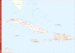
Ecuador
!
!
Logistics Sector Concept of Operations - 05 July 2016
fh
!
!
Pitalito
Pradera !
Tumaco
!
!
Florencia
!
Quito
San Lorenzo
de Esmeraldas
!
g
!!!
m
!
!
Esmeraldas
!
Atacames
!
h
!
h
ESMERALDAS
g
!!!
m
CARCHI
!
Rosa
Zarate
c
Ibarra
ZONA NO DELIMITADA IMBABURA
Otavalo
Lagartera
!
!
!Chamanga
0°0'0"
Manta
Bahía de
Caráquez
!
Chone
!
g
!! !
m
c
!
h
Santa
Ana
Jipijapa
!
!
2°0'0"S
SANTA
Salinas
! Libertad
La
ELENA
!
h
Santa
Elena
!
!
o
!
(
Mera
!
Puyo
!
PASTAZA
Arapicos
CHIMBORAZO
Samborondón
!
Montalvo
!
o
!
(
!
h
Guayaquil
Macas
ZONA NO DELIMITADA
La Troncal
!
Playas
Hacienda
El!Triunfo
Puerto
Bolívar
!!
Santa
Rosa
!
Arenillas
Tumbes
!
!
EL ORO Piñas
Zorritos
!
!
Gualaceo
o
!
(
Cuenca !
!
MORONA
SANTIAGO
Santiago
de Méndez!
!
Taisha
!
Sucúa
!
Cañar
CANAR
!
!
Patuca
!
AZUAY MARISCAL LAMAR
!
h
4°0'0"S
ORELLANA
JUMANDY
!
Gualaquiza
!
Buena Fé
!
Catamayo Loja
!
!
ZAMORA
CHINCHIPE
PERU
LOJA Changaymina
!
Macará
Tiputini
!
San Miguel de Salcedo
Arajuno
Ambato
!
Milagro
!
Rocafuerte
!
!
!
! Eloy Alfaro
Los
Organos
!
Tena
!
!
Guale El Carmen
Riobamba! Hacienda
!
Julia ! ! Pozuelos
! El Vergel
Babahoyo
Zamora
!
!
JOSE JOAQUIN DE OLMEDO
NAPO
!
ECUADOR
LOS RIOS
GUAYAS
Limoncocha
!
!
San
Pedro
!
Tarapoa
!
Shushufindi
!
BOLIVAR TUNGURAHUA
Balzar
!
SUCUMBIOS
!
!
oLatacunga
!
(
!
!
Nueva
Loja
!
Machachi
!
Velasco !La Maná
Ibarra
!
Quevedo
!
h(
o Jaramijó
!
Portoviejo
Manta ! !
Montecristi !
.
!
\
Arca de
Agua
!
!
o
!
o(
Quito !
(
Tumbaco
COTOPAXI COTOPAXI
Calceta
!
San
Miguel
!
!
SANTO DOMINGO
DE LOS
TSACHILAS
MANABI
Puerto
Asís
!
PICHINCHA MARISCAL SUCRE
Santo Domingo de
los Colorados!
Jama
Orito
San
Gabriel
Cayambe
La Concordia
!
!
o
!
(
!
!
Pedernales !
Mocoa
TENIENTE CORONEL LUIS A MANTILLA
Tulcán !
!
Pedernales
COLOMBIA
Pasto
c
Cariamanga
!
!
Talara
!
!
Sullana
!
Paita
Chulucanas
!
0
!
50
±
100
200
Kilometers
!
La Arena
!
80°0'0"W
!
Date Created: 05 July 2016
Contact: [email protected]
Website: www.logcluster.org
Prepared by: HQ, OSEP GIS
Map Reference:
ECU_CONOPS_A4P
b
Logistics Hub
78°0'0"W
!
g
!
c
!
m
Coordination
Information Management
Warehouse
!
\
!
!
!
!
!
!
!
!
h
o
!
(
National Capital
Major Town
Intermediate Town
Ports
International! Airport
76°0'0"W
International Boundary
First Level Admin Boundary
River
!
Surface
Waterbody
!
Data sources: WFP, UNGIWG, GeoNames,
GAUL
The designations employed and the presentation of
material in!the map(s) do not imply the expression of any
opinion on the part of WFP concerning the legal or
constitutional status of any country, territory, city or sea,
or concerning the delimitation of its frontiers or
© World Food Programme 2016


© Copyright 2026